| GISdevelopment.net ---> AARS ---> ACRS 2004 ---> GPS & Photogrammetry: Navigation System |
GPS based Ionospheric
Scintillation for Space Weather
Prasert Kenpankho and
Peerawut Suwanjan
Department of Engineering Education, Faculty of Industrial Education
King Mongkut’s Institute of Technology Ladkrabang
Chalongkrung Road, Bangkok 10520, Thailand
Email: kkpraser@kmitl.ac.th, kspeeraw@kmitl.ac.th
Department of Engineering Education, Faculty of Industrial Education
King Mongkut’s Institute of Technology Ladkrabang
Chalongkrung Road, Bangkok 10520, Thailand
Email: kkpraser@kmitl.ac.th, kspeeraw@kmitl.ac.th
ABSTRACT
A permanent monitoring of the ionospheric scintillation on global scale is required because the ionosphere region represents an active role in the complex space weather relationships. The world-wide using of Global Navigation Satellite Systems (GNSS) such as GPS offers the unique chance for a permanent monitoring of the total ionization (Total Electron Content - TEC) of the global ionosphere up to about 20000 km height. On the other hand, accuracy and reliability of GNSS suffer from the ionospheric impact on GPS signals. This paper discusses several space weather effects in the ionosphere detected by measurement in the GPS tracking network of the International GPS Service (IGS). Under normal circumstances, errors due to GPS signals traveling through the ionosphere can be modeled by measurement on two (or more) frequencies. However, during periods of disturbances such as scintillations, this can be impractical and receiver performance can be severely degraded. The ionospheric scintillations are most likely to occur during solar maximum, particularly affecting equatorial and aurora regions. A direct correlation between space weather events and phase degradation of GPS signals for positioning has been found. The derived signal phase irregularities that degrade navigation and positioning applications indicate highly variable horizontal structures. The discussion of ionospheric irregularities is completed by several simulation scenarios showing their influence on positioning.
1. INTRODUCTION
The influence of the modeling ionospheric effects is a major concern for GPS positioning and navigation applications as Fig. 1. Dual frequency receivers allow for the combination of measurements to produce a first order correction to the ionospheric delay, which is dependent on the total electron content. The regular behavior of the ionosphere, which is fundamental to accurately model these effects, is greatly influenced by solar activity. Ionospheric scintillation is the most significant disturbance that can affect GPS users during years of high sun spot activity and is likely to occur in equatorial and auroral regions. The electromagnetic interaction of radio waves with charged particles of the ionospheric plasma may cause on the one hand a significant degradation of navigation signals. On the other hand, measurable changes in phase, amplitude and polarization of transmitted radio waves can effectively be used to obtain essential information about the ionospheric state. Furthermore North-South gradients in ionospheric activity may affect regional positioning networks the mid-latitudes. GPS signals traveling through the ionosphere on their way to user receivers are subject to significant errors, which depend on the signal frequency and the ionospheric electron content. These errors can be mitigated, under normal circumstances, either by predictive modeling of the ionosphere’s activity, or by measurement on two or more frequencies. However, during periods of disturbances such as scintillations, the modeling can be rendered impractical and receiver performance can be severely degraded. Although isolated efforts have been reported, there is no mechanism currently in place to warn of, or against, scintillation effects. There has not been any significant quantity of data acquired during ionospheric disturbance or systematic analysis of the effects on positioning systems.

Fig. 1 Ionosphere Effects
2. GPS RECEIVER DESCRIPTION
A block diagram of a typical GPS C/A code receiver is shown in Fig. 2 [1]. The RF signal is received by an L-band antenna. This signal is filtered and then amplified by a low noise amplifier (LNA). Next, the signal is down converted to a convenient intermediate frequency (IF) and converted from analog to digital (A/D). The digital signal is then passed to a bank of N channels (see Fig. 3) that form complex sums of the correlation between the input signal and C/A code replicas. One channel is needed for each satellite to be tracked. The complex correlation sums are used by a processing unit to track the code and carrier of the received signals so that pseudo ranges to each satellite can be estimated. The correlation sums are also used by the processor to demodulate the data.
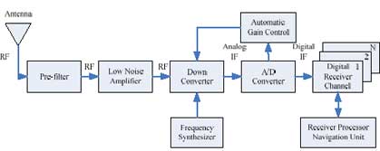
Fig. 2 GPS Receiver Overview

Fig. 3 Receiver Channel
In this paper, we defined a statistical model of scintillation signal coupled with a model of receiver processing for L1 (1575.42 MHz) GPS and Satellite Based Augmentation System (SBAS) carrier and code tracking loops as well as semi codeless L2 (1227.6 MHz) carrier and Y code tracking capabilities.
3. IONOSPHERIC SCINTILLATION
Ionospheric scintillation is a rapid change in the amplitude or phase of a radio signal as it passes through small scale plasma density irregularities in the ionosphere. Scintillation estimates are given in terms of a Power Spectral Density (PSD) of phase scintillation of the form following as

where f is frequency (Hz) (greater than or equal to a cutoff frequency) T is a strength parameter (rad 2 / Hz) corresponding to the power at 1 Hz p is a unit less slope Scintillation in the ionosphere varies according to Sunspot Number (SSN) , geomagnetic index (0 <Kp< 9), time of year, time of day, and geographical position. A receiver’s ability to cope with scintillation will be affected by these factors, and the azimuth and elevation of the observed satellite which indicate what part and how much of the ionosphere a radio signal must pass through.
4. SPACE WEATHER CASE ANALYSIS
In the ionosphere the space weather event is accompanied by strong enhancements of nighttime ionization in the polar region. Geomagnetic and ionospheric storms generate significant large scale signatures in the TEC maps [2]. In particular differential TEC maps generated by subtracting monthly averages from actual TEC maps are helpful to draw conclusions concerning the nature of ionospheric storm processes. So the corresponding analyses of the storm on 10 January, 1997 indicate both the action of an eastward directed electric field as well as the action of perturbation induced meridional winds in the thermosphere. Furthermore, statistical studies showed characteristic storm pattern of percentage TEC deviations from monthly medians fro winter and summer storms [3]. The storm pattern provides a deeper insight into storm mechanisms and may be useful fro an adequate modeling of ionospheric storm behavior in space weather forecast models. As Fig. 1a shows, there is a strong ionization enhancement near the geomagnetic pole (marked by a black cross) around 21: UT that is even bigger than the ionization at latitude f > 50 °N at the longitude sector on the day side. For comparison Fig. 1b shows the same area 24 hours later indicating a reduced ionization level in general that is well known as the negative storm phase
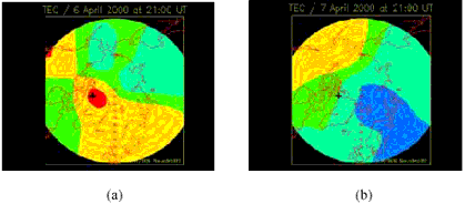
Fig. 1 Vertical TEC over the North pole at 21:00 UT on 6 April, 2000 (top) and on 7 April, 2000 (bottom)
We suppose that the strong impact on the magnetosphere and ionosphere systems in the evening hours of 6 April is due to the southward direction of the interplanetary magnetic field that has been measured from about 17:00 until 24:00 UT with a short break around 22:00 UT. Principally, the polar ionization is strongly irregular between 17:00 and 24:00 UT.
5. CONCLUSION
The approach of this study is to generate estimates of ionospheric scintillation by using GPS signal related to different ionospheric conditions, times and locations and determine what effect as space weather would be seen by a user receiver after receiver processing. The result from GPS signal indicates that it is possible by using GPS based ionospheric scintillation to show or predict space weather.
6. REFERENCES
- Ward, P., 1995. Dual Use of Military Anti-Jam GPS Receiver Design Techniques for Commercial Aviation RF Interference Integrity Monitoring. Navigation: The Journal of the Institute of Navigation, 41(4).
- Jakowski, N., Schluter, S., and Sardon, E., 1999. Total Electron Content of the Ionosphere During the Geomagnetic Strom. J.Atmos. Solar-Terr.Phys., 61, pp. 299-307.
- Forster, M. and Jakowski, N., 2000. Geomagnetic Storm Effects on the Topside Ionosphere and Plasmasphere: A Compact Tutorial and New Results. Surveys in Geophysics, 21(1), pp. 47- 87.