| GISdevelopment.net ---> AARS ---> ACRS 2004 ---> New Generation Sensors and Applications: New Generation Sensors |
LIDAR Surveys for Road Design
in Thailand
Mr. Chanchai
Techashongs
Department of Highway, Bangkok, Thailand;
Maj.Gen. Lek Chudasuta
Royal Thai Survey Department, Bangkok, Thailand;
Dr. Phisan Santitamnont
Chulalongkorn University, Bangkok, Thailand ,
E-mail: phisan@chula.com
Dr. Rejean Simard
Lasermap Asia, Kuala Lumpur, Malaysia,
E-mail: rejean@lasermap.com
Mr. Pierre Belanger
GPR Consultants Lasermap, Boisbriand, Canada,
E-mail: pierreb@lasermap.com
ABSTRACT
Concerned with environmental and drainage problems associated with road infrastructure that can greatly affect the populations located in its vicinity, the Department of Highways of Thailand (DOH) is looking for ways to minimize the impact of new road construction and maintenance. In particular, roads and highways often need to be built in high-risk and sensitive areas such as hilly, unstable terrain. LiDAR technology is of great interest to DOH as its use can make them save enormous amounts of time and money by providing highly precise elevation data in all kinds of environments including harsh and rugged areas. Generally, survey and design for a common highway requires about 7-8 months for completion while major projects require at least 12 months. Among the many technological improvements introduced over the past years, GIS has been adopted to a certain extent to enhance survey and design capability development. The integration of LiDAR-produced digital elevation models into their existing GIS databases will greatly improve DOH's capacity and efficiency in highway design and associated steps.
LaserMap GPR Consultants of Canada is undertaking, together with DOH, Royal Thai Survey Department and Chulalongkorn University, a pilot study located near the New Bangkok International Airport that aims to demonstrate the usefulness and practicality of using this kind of surveys for road construction and maintenance projects in Thailand.
INTRODUCTION TO LIDAR TECHNOLOGY
The relatively new LiDAR technology uses a rapidly firing laser installed in an aircraft for measuring points on the ground. The strength of the laser and its narrow, infrared beam allow it to penetrate between much of the leaves and branches and often receive a return reflection from the ground. A Global Positioning System (GPS) and an Inertial Measurement Unit (IMU), which are integral parts of the equipment, allow for continuous monitoring of the position of the aircraft and its attitude. Using all of this equipment together with timing coordinated to the milli-second, the post processing of the data allows the construction of a detailed digital terrain model.
The components for LiDAR technology have been around for many years. Lasers were invented in 1958. Inertial technology has been around for a long time and GPS has been around commercially for over 15 years. The challenges faced by user of LiDAR technology is putting all of these technology-components together and making them work together – at the same time ensuring that it is small enough for use in an aircraft or helicopter. In reality this has only been achieved commercially in the last eight years or so.
The major limiting factor for the technology has always been (and still is) the airborne GPS and it is only in the last ten years that GPS systems have become accurate enough to provide airborne positions better than 10cm.
With respect to the use of a GPS on board the aircraft, it is necessary to provide a link to a ground GPS station on a known control point. The ground station should be located on or close to the project site - where the aircraft is flying. This is to ensure that the aircraft record the same satellites signal as the ground station. If the ground station is located further away from the aircraft or project site then it is quite possible some of the satellites recorded by the ground station will be different from those recorded by the aircraft GPS. There are a number of other reasons also: absolute accuracy tends to diminish the further away the aircraft is from the ground station.
Just to clarify a point: the accuracy of the system does not change when it is further away from the ground station; it produces data within the same relative accuracy parameters all of the time – but the accuracy in relation to the absolute ground position changes when the airplane get further away from a ground station.
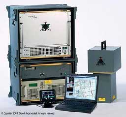
The direct result of a LiDAR survey is actually a set of points which consist of easting northing elevation obtained at the rate of 3 million points per minute (meaning a spatial density as small as 1m apart) as in the case of LiDAR models like the Optech 2050 (see Figure 1 shown left) owned by LaserMap which also produce infrared laser intensity maps.
The point data are then post processed and classified into three main classes of points. The last return ground, the first return tops of vegetation or buildings or structures.
Ground bare earth points can be used as a Digital Terrain Model (DTM) or converted to contours or, as we will see later, a relief model. The vegetation can be used to determine the heights of trees and using specific software calculate biomass or even expected lumber that could be cut in any specific stand.
In addition, the intensity feature allows the brightness of the reflected return to be recorded as a value between 0 and 255. This can then be rendered to produce an image of what is on the ground which is similar to an infrared photo. While this is not close to photographic colour quality it does allow interpretation of what is on the ground.
LiDAR missions are planned very similarly to aerial photo missions. However, the LiDAR aircraft is usually flying much lower (between 1000-3000 metres) and lines are spaced closer together as the beam width is relatively narrow. LiDAR data can (and often are) used together with standard air photo or a more advanced CCD camera to produce digitally rectified images or othophotos. The DTM is used to rectify the image taking out the distortions caused by relief. This saves time and money compared to collecting a terrain model by photogrammetry. However, it should be noted that it is rare that a LiDAR system and a precision aerial camera are flown at the same time, as the swath width covered by the camera is not the same as that covered by the LiDAR. But Lasermap GPR can fly LiDAR and CCD camera at the same time on the same platform.
The following is a list of the main advantages of using LiDAR as a survey technology:
- The data are all collected numerically.
- The laser is an active sensor so it does not require specific sunlight conditions or even daylight; it can be flown under the clouds so well suited to tropical environment,
- It is an aerial survey, so data are collected quickly and accurately and do not need field intervention.
- The automated processing helps speed data analysis
- The high precision of the data allows its use for planning and detailed engineering
- It provides data in areas difficult to access or where it is environmentally sensitive
- And because the data are generic by nature (digital) they can be used in many different software packages and used to generate different views.
LiDAR can be applied in a multitude of applications requiring large scale mapping with most of them related to infrastructure development or maintenance. The following table presents the main applications areas.
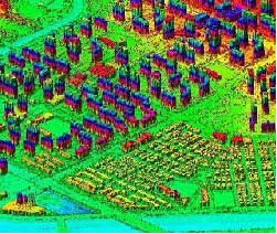
Figure 2 shown beside, © 2002, LaserMap Image Plus. All rights reserved, is a sample type of data collected by LaserMap over the years - an isometric view of a terrain model for a downtown in Bun Dang City in Korea. These data are collected over a dense urban area and can be used, for example, for wireless communication network coverage analysis for optimal antenna locatization; or by security forces for disaster preparedness and mitigation.
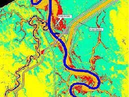
Over the recent years, flood risk mapping has been a significant part of LaserMap’s work in Canada. For example on Figure 3 shown beside , © 2002, LaserMap Image Plus. All rights reserved, on the Canadian USA border in Manitoba, in central Canada, a large area was flooded in the Red River flood plain. The area shown is about eight kilometres wide. Using LiDAR the engineers were able to see where the flood lines were located and then try to take various measures to reduce risk in the future. Closer to South-East Asia, LaserMap was involved in LiDAR surveys for Public Works Department Malaysia.
The following example was completed in Sabah during the year 2002. The final result was a block of digital terrain data accurate to 30 cm for the length of a 300km road near Kota Kinebalu (a portion of the results is shown beside at Figure 4 © 2002, LaserMap Image Plus. All rights reserved).
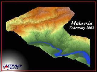
This allowed Public Works Department Malaysia to assess the degree of slopes, the hydrology, and the high-risk areas so that the re-engineering of the road will avoid the most likely landslide areas and provide a safe and continuously open road throughout the year. Public Works Department Malaysia assigned a foreign independent surveying firm to check the conducted LiDAR survey with cross sections in several places and found that the results exceeded the specifications for the survey more than 99% of the time.
LIDAR SURVEY IN PILOT PROJECT WITH DOH, THAILAND IN 2004
Concerned with environmental as well as drainage problems associated with road infrastructure that can greatly affect the populations located in its vicinity, the Department of Highways of Thailand (DOH) is looking for ways to minimize the impact of new road construction and maintenance. In particular, roads and highways often need to be built in high-risk and sensitive zones such as hilly, unstable terrain. In the next few years, a large number of roads and highways will need to be built in zones such as;
Several engineering techniques have been developed over the years to solve such problems but all deal with a very small surface, that is, along a narrow corridor that borders the road/highway. However, the impact of road construction goes far beyond this immediate corridor and DOH realizes that it now needs to consider a much larger surface area.
LiDAR technology is of great interest to DOH as they understand that its use can make them save enormous amounts of time and money by providing highly precise elevation data in all kinds of environments including harsh and rugged areas. Quality survey and design work for highway development requires efficiency in every step of the process from project planning, price estimation, construction method preparation, contractor pre-qualification, bidding, personnel management, budget management, equipment management, materials management, land acquisition, quality control, follow-up, post evaluation and public promotion. Generally, survey and design for a common highway requires about 7-8 months for completion while major projects or interchange require at least 12 months. The integration of LiDAR-produced DEMs into their existing GIS databases will greatly improve DOH's capacity for and efficiency in highway design and associated steps.
DOH, together with Royal Thai Survey Department and Chulalongkorn University, is undertaking with Lasermap GPR Consultants Inc. of Canada, a pilot study that will demonstrate the usefulness and practicality of using this kind of surveys for road construction and maintenance projects in Thailand. Many parameters need to be analyzed and engineering models need to be tested before DOH can fully understand and adapt this new technology to fit its current operational needs. The detailed mapping of high-risk and sensitive zones where new road are planned presents great interest to DOH.
Thus, the objective of the pilot study is to define a macro-surface model based on high-precision terrain data acquired through airborne LiDAR. Such highly-precise terrain data, along with data on population density, geomorphology, pedology, flood extent and drainage and so on, will allow engineers to simulate various corridor locations and determine which would cause the least impact on the environment and surrounding populations.
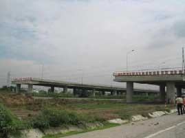
Lasermap GPR is using the Optech LiDAR ALTM 2050 system for the pilot project survey for an area of 15km by 15 km located near the New Bangkok International Airport (Figure 5 on the right shows a portion of construction near NBIA as of August 2004). The LiDAR survey will also cover a 50 linear kilometer portion of the motorway that will link the NBIA to Chanburi. Beside DTMs, laser intensity maps will also be obtained for all survey areas.
Even during the monsoon period, it will be possible to fly the aircraft with LiDAR below the persistent cloud cover if not raining. By adjusting the forward speed of the aircraft and overlapping lines of data capture to form a block of data, the resulting terrain model produced data points that will be spaced approximately one meter apart. While not every single laser shot penetrates to the ground because it hits some impenetrable vegetation, the survey will provide a very detailed ground model.
To ensure the airborne survey is on the proper local datum, a ground based survey-grade, global positioning system will be located on ground control points for the duration of the airborne survey and records the same satellite data as the aircraft’s GPS. This allows a three dimensional transformation of the LiDAR survey data into the ground coordinates to be used later by DOH The LiDAR unit records all data in the World Geodetic System based on the GPS satellites, and as with any GPS survey this needs to be transformed by special software into the local survey system. The actual LiDAR survey will take only a few hours within the same day. The complete processing of the LiDAR data is to completed within a month.
It is expected that preliminary results of the LiDAR survey over the New Bangkok International Airport will be presented at the ACRS 2004 Conference. We are confident that the results obtained through the pilot study will demonstrate the benefit to DOH to use airborne LiDAR services for a large portion, if not all, of their future road construction projects in high-risk zones.
CONCLUSION
Airborne LiDAR technology is now a proven method for acquiring accurate digital terrain model data and associated imagery under a wide range of conditions. As an active sensor it can be used when other remote sensing tools will not work.
LiDAR technology is expected to improve the way DOH is currently performing terrain mapping by land surveying (which is slow and difficult in remote and rugged areas). It should save DOH considerable amounts of time during the design phase of road projects and save costs during the actual construction (by reducing cut and fill works) or maintenance jobs (through slope analysis to reduce the risk of landslides for example). It should be noted that although this technology has been operational in many countries for a number of years, it was never been applied in Thailand as of August 2004.
This new source of data bundled with advanced visualization software is an essential ingredient for any major development project that needs high-resolution and high-precision cartographic information, be it road or railway construction or improvement, telecommunication transmission lines, power lines, high-precision digital topography for slope analysis in landslide risk mapping or for flood risk mapping, interactive fly-through simulations for land developers, and so on.
ACKNOWLEDGEMENTS
The authors wish to acknowledge the most valued contribution of the Canadian International Development Agency (CIDA) in financially supporting the project with DOH. Most appreciations are also directed to the Canadian Embassy in Thailand, especially to Khun Veena Ngaocharoenchitr for her efficient assistance, as well as to Thai supporting companies such as TIS-TEAM consulting firm and Thai Flying Service Co. Ltd.
REFERENCES
- Fowler, Robert., 2001. Topographic Lidar, Chapter 7, Digital Elevation Model Technologies and Applications, Editor Dr. David Maune, published by The American Society of Photogrammetry and Remote Sensing.
- Hartman, Jim, 2003. P.Eng. LiDAR Surveying: A Tool for Flood Risk Mapping and Engineering, Earth Observation Magazine June, pp 32-36.