| GISdevelopment.net ---> AARS ---> ACRS 2004 ---> New Generation Sensors and Applications: New Generation Sensors |
Terminals on the Base of
Untscan™ Technology – The Newest Solution for Monitoring of the Earth From
Space
Olga
Gershenzon
vice-president, R&D Center ScanEx, Russian Federation
ph./fax +7 (095) 246-2593,
E-mail: info@scanex.ru
vice-president, R&D Center ScanEx, Russian Federation
ph./fax +7 (095) 246-2593,
E-mail: info@scanex.ru
ABSTRACT:
R&D Center ScanEx (www.scanex.ru) is leading manufacturer of personal ground stations and terminals, i.e. antenna systems for receiving, storing and processing Earth observation images. Their unique features compared to the traditional systems for gathering information about the Earth from space are as follows: affordable price, compactness, a technology on the basis of a standard PC, ease of the operation, a unified technology of data storage, processing, and image thematic analysis. All of these leads to cheaper data, simpler data acquisition technology, and quicker access time for the widest possible range of users. A personal ground station is the unique means to enable users to receive images of the Earth from space directly at their PCs. UniScan™ ground station (in stationary and mobile modifications) by R&D Center ScanEx is flexible solution for receiving information from wide range of Earth observation satellites: Terra/Aqua, IRS-1C,1D,P6, RADARSAT-1, EROS A1 and others. R&D Center ScanEx offers the complete chain for RS data acquisition, storage and processing on the base of its own hardware and software solutions. Affordable price of ground stations makes it possible to install such equipment not only for national remote sensing Centers, but at research, education organizations. The main possibility that gives UniScan™ technology is access to RS data in real-time mode – data is ready to analysis after 15-30 minutes after data reception. This is too important for such RS data applications as disaster management (flooding, fires monitoring). R&D Center ScanEx in cooperation with Antrix Corp. offers integrated solution for acquisition information from recently launched IRS-P6 satellite by affordable price which includes hardware, software and 1,000 minutes time for data downlink. IRS-P6 data with resolution of 5.8, 23 and 56 m and short revisit period (5, 24 and 5 days correspondingly) make this data valuable for very different RS data applications.
INTRODUCTION
We consider remote sensing terminals (RS terminals) – compact, affordable, simple for operation systems for acquisition images of the Earth from space- as significant stage in realization of the idea of decentralization, speeding-up and simplification of access to RS data. When we need one image for definite date for limited area of interest we can use service of centralized archives even if time of data delivery and data cost are not convenient for us. Centralized archives we understand as several global archives where RS data are received, processed and stored. Usually it takes much time for delivery ordered image to end user, and long chain of RS data distributors, companies offering service for value-added products very complicates access to RS data and increases its cost. But in case we want to integrate images from space into on-line decision-making system cost of images and time of its delivery are crucial parameters.
Really RS terminals and personal ground stations (PGS) for RS data acquisition and processing (by analogy with personal computers) enable to use images from space just after 15- 30 minutes after data reception on a place of decision-making. Such approach is in principle important both on the level of governmental bodies, regional administrations and large industrial corporations.
In particular this caused wide implementation of RS terminals on the base of UniScan™ technology in frames of Ministry of Natural Resources of Russian Federation (Moscow, Gelendzhik, Irkutsk, Ekaterinburg, Yakutsk, Yuzhno-Sakhalinsk - see figure 1), in the interests of regional administrations (Belgorod, Chita, Salekhard – see figure 1) and large industrial companies (Atyrau, Priozersk – “KazGeoCosmos” Company, figure 1). In spite of difference in the status and organizational form of above-mentioned users the list of problems that they resolve is varied only in geographic features of regions. This list includes following applied tasks: detecting of wildfires and forecast of their development, water pollution monitoring (thermal pollutions and oil spills), forests monitoring (illegal felling, consequences after wildfires, etc.), control over compliance with the licensing agreements in natural resources development, control over illegal fishing, monitoring of regional infrastructure development, rapid and objective damage assessment after natural disasters and others.
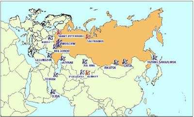
Figure 1. Operational UniScan™ ground stations network
WHAT IS UNISCAN™ GROUND STATION AND RS TERMINALS
What do we mean when we say Personal Ground stations and terminals? We mean antenna systems for receiving, storing and processing Earth observation images. Their unique features compared to the traditional systems for gathering information about the Earth from space are as follows: affordable price, compactness, a technology on the basis of a standard PC, ease of the operation, a unified technology of data storage, processing, and image thematic analysis. All of these leads to cheaper data, simpler data acquisition technology, and quicker access time for the widest possible range of users. A personal ground station is the unique means to enable users to receive images of the Earth from space directly at their PCs. UniScan™ ground station (in stationary and mobile modifications) by R&D Center ScanEx is flexible solution for receiving information from wide range of Earth observation satellites: Terra/Aqua, IRS-1C,1D,P6, RADARSAT-1, EROS A and others.
UniScan™ station is designed for receiving and processing images transmitted from low-orbiting Earth satellites in X-band with data rates up to 120 Mbps (in near future up to 160 Mbps). Such data rate allows to transmit detailed images with the spatial resolution of several meters.
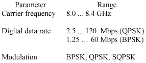
Main specifications of the UniScan™ station
UniScan™ hardware is universal and programmable. It provides for reception of information in any format, whose parameters are within the following limits:
The users would not need any hardware modifications to adapt the station for a new satellite and format, only some additional software will be required provided that:
- format parameters are within the limits indicated above;
- power of the satellite transmission is sufficient to be received by the particular antenna system.
UniScan™ is designed in two configurations:
- mesh-reflector antenna, 3.6 m in diameter with a 3-axis rotating support (UniScan™-36);
- solid-reflector antenna, 2.4 m in diameter with a 2-axis "X – Y" rotating support (UniScan™-24)
- the antenna system;
- the control unit;
- computer interface boards;
- an Intel Pentium IV based PC (one or two, see below);
- the software;
- a set of connecting cables.
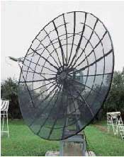
Figure 2. Antenna system of UniScan™-36
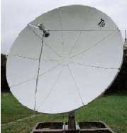
Figure 3. Antenna system of UniScan™-24
PCs for the UniScan™ station are capable of ingesting, logging and temporary storage of the relevant large data streams. If a station is intended for parallel data reception via two radio downlinks (as is the case with the IRS-1C/1D satellites), it is supplied with two PCs connected into a local network and two PC interfaces.
R&D Center ScanEx offers the complete chain for RS data acquisition, storage and processing on the base of its own hardware and software solutions. Affordable price of ground stations makes it possible to install such equipment not only for national remote sensing Centers, but at research, education organizations.
The system is equipped with specialised software for:
- the control of acquisition and data recording to a PC hard disc (ScanReceiver®);
- the preliminary processing (data formatting, geolocation and calibration). Definite structure of this software depends on station configuration, i.e. list of data to be acquired;
- the visualisation and analysis of images (ScanMagic®, one license);
- cataloguing images (ScanEx Catalogue Manager®);
- additional thematic image processing (ScanEx Image Processor®, one license).
Data recording and storage is implemented in formats developed by the R&D Center ScanEx. They preserve all of the metadata received from a satellite and the metadata added in the course of reception.
These formats are fully supported by the delivered software. It is also possible to obtain low-level products in standard formats such as
- MODIS: MOD 01, MOD 02, MOD 03 (Terra); MYD 01, MYD 02, MYD 03 (Aqua);
- IRS (LISS-3, PAN): FAST;
- RADARSAT: RADARSAT Level 0, Level1 in CEOS SAR formats.
Mobile receiving station based on the UniScan™ technology The mobile station is implemented in two configurations: on the base of UniScan™-24 and UniScan™-36 stations. In technical terms, the system is small and relatively light with the weight about 400 kg or 1,000 kg and a 2.4 m or 3.6 m antenna dish respectively. The system can be set up in a new location in 2 to 3 hours. Once the imagery is received, the advanced software for data reception, storage and processing enables the operator to analyse the situation and give relevant recommendations within a period of time as short as 30 minutes. For best results, the received images should be combined with background information such as local cartographic/GIS layers or geolocated archive imagery from Resurs-Î 1, Meteor-3M, Landsat, IRS or Terra satellites.
Unique features of the R&D Center ScanEx mobile receiving station:
- a simplified small-size antenna which enables reliable reception at satellite elevations starting from 5-10° with the radius of the reception zone up to 1,500 – 3,000 km;
- rapid operational deployment (2…3 hours) without the use of any additional equipment;
- low cost compared to similar stations by other manufacturers;
- high mobility (transported by a lightweight truck with a trailer).
- real-time data reception in emergency situations to enhance the efficiency of rescue operations and damage assessment;
- real-time data acquisition for the regions, not covered by the stationary receiving centers, to create imagery archives;
- deployment prior to the completion of a full-scale Earth observation center;
- creation of a national Earth observation infrastructure in developing countries;
- demonstration of Earth observation capabilities at international exhibitions and aerospace shows;
- specific Earth observation tasks in remote regions for a limited period of time (e.g. dealing with accidents and natural disasters, prospecting for oil, gas and other mineral resources, pipeline construction etc.).
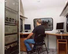
Figure 4. Indoor equipment of Mobile ground station
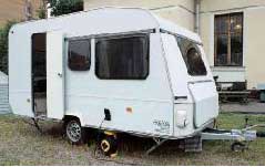
Figure 5. Mini-laboratory on the base of mini-trailer
The basic delivery set of the mobile receiving station consists of the same as UniScan™, but besides this includes a dismountable platform for antenna system installation and auxiliary equipment for a truck-mounted UniScan™-36 system.
By customer request, the following may be supplied in addition to the basic set: a light truck, a trailer equipped as a mobile laboratory, an autonomous petrol-based generator (220 V output, enables consumption of up to 2 kW). The particular components of the set are to be detailed in the mobile station delivery contract.
CONCLUSION
The main possibility that gives UniScan™ technology and terminals on its base is access to RS data in real-time mode – data is ready to analysis after 15-30 minutes after data reception. This is too important for RS data applications for any dynamic phenomena such as wildfires and their sites detection, oil slicks detection and control of their motion; crop quality on day by day (or at least a week by week) basis; control of water pollution on regular basis and so on.