| GISdevelopment.net ---> AARS ---> ACRS 2004 ---> New Generation Sensors and Applications: New Generation Sensors |
Study on the improvement of
instrument's image spatial resolution on the three-axis stabilized
platform
Guo Qiang 1,2,
Xu Jianmin 2
1 .Chinese Academy of Meteorological Science, Beijing, 100081
2 .National Satellite Meteorological Center, Beijing, 100081
No 46, Zhongguancun Nandajie, Haidian distric, Beijing, 100081, China
Tel: (86)-10-68406123 Fax: (86)-10-62176805
1 .Chinese Academy of Meteorological Science, Beijing, 100081
2 .National Satellite Meteorological Center, Beijing, 100081
No 46, Zhongguancun Nandajie, Haidian distric, Beijing, 100081, China
Tel: (86)-10-68406123 Fax: (86)-10-62176805
ABSTRACT:
As for the space-to-earth observation, high spatial resolution is always what the remote-sensing instrument’s designers and application users pursue. However, it is usually limited by the instruments’ optical diffraction in theory. Fortunately, with the development of the high accurate scanning control and positioning technologies, the sensor’s manufacture techniques as well as the high speed processing on ground, it can be reality that the spatial resolution of the images generated by the optical instruments with linear sensors on the three-axis stabilized platform could be improved in a certain degree by changing the sensors’ relative positions, increasing over-sampling ratio with high enough accurate positioning controls and some image-processing operations. The full physical and mathematic models and their corresponding algorithm realizations, namely two main processing ways, one is the pure mathematic method and the other is the mixed method based on the real physical process, are discussed in this paper completely. At the same time, the spreading error induced by the technology is quantitatively analyzed and the relationship between the image spatial resolution and the image SNR based on the model, which is verified by the simulation samples, is also presented. The feasibility of the method is proved by the patent technology of the SPOT-5 HRG. Considering that doubling the spatial resolution is sacrifice of 10.2dB in image SNR, this technology firstly can be applied in the polar orbit three-axis stabilized platform at current technological conditions. And, with development of the sensor’s and the cooler’s performances further, it can be also used in the geostationary orbit platform in the future. The researching results may offer the new philosophy for the instruments’ designs and will promote the observation performance of the total system.
1. Introduction
As for the space-to-earth observation, the higher spectral and spatial resolutions are always pursued in development of remote sensing instruments. It is considered that the spatial resolution of the instrument, under the condition of the proper signal to noise ratio, is determined by the instruments’ instant field of view (IFOV) to a large extent. In other words, the spatial resolution of instrument is determined by optical and physical character of instrument. On the other hand, for the imaging instruments, attention is focused on the spatial resolution of remote sensing images (below referred as images) processed on ground.
With the development of modern high accuracy servo control technology and the high speed digital signal processing technology, the accuracy of the two-dimension scan servo control system of the instruments on board of the geostationary satellites may reach five micro-radians in orbit which equals to one-fifth to one-sixth VIS pixels as well as one micro-radian in lab. Taking into consideration of the present technical conditions, it is proposed that changing the sensors’ relative positions as well as increasing over-sampling ratio could improve the spatial resolution of the images, which is generated by the optical instruments with linear sensors on the three-axis stabilized platform, by a certain degree. At the same time, the digitalized process is adopted to enhance the image spatial resolution. Based on the strict mathematic model, the technical possibility of the method was analyzed by relative application examples and simulation results.
2. The basic mathematic model and the algorithm analysis
2.1 The basic mathematic model
For the linear sensor with different relative positions and different over-sampling ratios, the spatial resolution of the image varies with changes of sampling positions. Given a N ´1 linear sensor, each pixel’s size is Xe ´Ye and the scanning is along with the X direction with the over-sampling ratio of t. As examples, one-column positioning and two-column positioning are discussed in this paper while t equal to 2 and the general final conclusion can be drawn, as shown in figure 1.
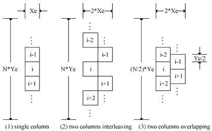
Figure 1 one or two columns positioning sketch
As an example, the conditions of the double sampling and the two-column overlapping positioning will be used to extract the spatial resolution of the image as shown in figure 2(c). Let us assume that each detector’s IFOV is IGFOV x d ´IGFOV y d, which is divided into four sub-blocks, the weight for each sub-block is shown in figure 3(a) and the acquired signals are future processed to remove dark current, non-linearity, non-uniform, dark pixels and so on. The final output value of each pixel can be expressed by:
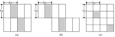
Figure 2 over-sampling sketch for three different modes (double sampling)
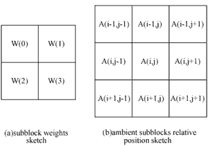
Figure 3 two columns double sampling structure sketch
And Sk(i,j) is the kth acquisition value including the A(i,j) sub-block. Assumed that the total acquisition times in one imaging is M, so the uniform equation can be expressed by:
2.2 The algorithm analysis
In this section, equation 3 solutions and the feasible of methods solution are discussed. Obviously, ij ij 2M ) ) ' = = rank(W rank(W , so 2MN ) ˆ = rank(W , which means that the 2MN line vectors in matrix W ˆ are not linear correlation. At the same time, the column vector T S ˆ can be presented by the weight matrix W ˆ and the number of column is larger than that of the line, 1) 1)(N 2(M > + + 2MN), so the solution of the equation 3 could be various. Considering the application, the stable solution vector T A ˆ can be acquired by setting the boundary condition according to the outer space background properly. Here, during the algorithm realization, we should pay more attention to the following three aspects: (1) fast algorithm for matrix equation, (2) boundary condition and (3) analysis of algorithm stability. The relative detail statements can be found in the reference (Guo, 2003a) .
3 The algorithm reliability verification
To verify the algorithm reliability, an application example is give below. For VIS channel images of the FY-2B, the low-sampling ratio is performed to produce images of low spatial resolutions. Before the data being processed, the spatial sampling represents the spatial resolution in general.
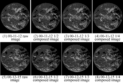
Figure 4 1/N composed images for VIS channel
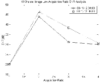
Figure 5 SNR contrast of different low composed ratio of VIS channel images
Here, two VIS channel images between November 2000 and December 2000 are selected and processed by the low-sampling ratio composition. For the 1/N composition, the images are averaged in the weight window of N ´N. When ignoring the non-homogeneity and non-linear of the detectors and the scanning control system, the geometric average is used. The output images are shown in figure 4.
Figure 5 indicates the SNR comparing results of different low composed ratio of VIS images. As we can see, because of the different acquisition time for the two images, the first and the second are at the GMT 04:00~05:00, the range of response of the three images are slightly different, so the acquisition ratios relative to the maximum SNR of the images are also different. With the increase of the acquisition ratio from the peak SNR point, the SNR of the image will decrease. For example, when the acquisition ratio reaches the double times of the peak point, the SNR will be reduced by about 10~13dB, which is complied with the analysis results in conference (Guo, 2003b).
4 Conclusions
In this paper, the discussion is concentrated on the method for improving the spatial resolutions of the images derived from three-axis stabilized geostationary satellites by changing the detectors positioning, increasing the over-sampling ratios and the high-speed digital processing on ground. At the same time, the spreading error induced by the technology is quantitatively analyzed and the relationship between the image spatial resolution and the image SNR based on the model, which is verified by the simulation samples, is also presented. The feasibility of the method is proved by the patent technology of the SPOT-5 HRG. Considering that doubling the spatial resolution is sacrifice of 10.2dB in image SNR, this technology firstly can be applied in the polar orbit three-axis stabilized platform at current technological conditions. And, with development of the sensor’s and the cooler’s performances further, it can be also used in the geostationary orbit platform in the future. The researching results may offer the new philosophy for the instruments’ designs and will promote the observation performance of the total system.
REFERENCE
- James J. Shea, 1996. On-orbit MTF measurements. SPIE, 2812, pp.221-228. L.M.Candell, D.M.Weitz, 1996. Electronics considerations for a geostationary interferometer sounder. SPIE, 2812, pp.446-452.
- Guo Qiang, Chen Gui-lin, 2003a. A Fast Algorithm of Earth-edge Detection for Space Remote Sensing Images Under Strong Noises, Infrared and Microwave, 22, pp368-372.
- GUO Qiang, 2003b. Study On the real-time evaluation for the qualities of images of the synchronous meteorological satellites. Shanghai Institute of Technological Physics, C.A.S. Ph. D. Dissertation.