| GISdevelopment.net ---> AARS ---> ACRS 2004 ---> Data Processing: High Resolution Data Processing |
Modis Cloud Masking for South
east Asia Region
Vivarad PHONEKEO, Preesan
RAKWATIN, Lal SAMARAKOON, Ryuzo YOKOYAMA
Asian Center for Research on Remote Sensing (ACRoRS)
Asian Institute of Technology (AIT)
P.O.Box 4, Khlong Luang, Pathumthani 12120
Tel: (66)-2-542-6197 Fax: (66)-2-524-6147
Email: vivarad@ait.ac.th
Asian Center for Research on Remote Sensing (ACRoRS)
Asian Institute of Technology (AIT)
P.O.Box 4, Khlong Luang, Pathumthani 12120
Tel: (66)-2-542-6197 Fax: (66)-2-524-6147
Email: vivarad@ait.ac.th
Combination Threshold
Our study is to develop cloud-masking algorithm applied to MODIS images over South East
Asia region, which could be different from other areas in terms of surface characteristics and atmospheric conditions.
Clouds are normally characterized by higher reflectance and lower temperature (below 0°C to 20°C) than earth surface. However, very thin cloud has low reflectance and low temperature. Low altitude cloud (including fog) has high reflectance but not necessarily low temperature. From these characteristics, multispectral statistic technique based on visible and infrared threshold is applied.
Our methodology is first randomly select sample areas of cloud, land, and sea by 10 by10 pixels of MODIS 1km resolution. Then we calculate min, max, mean, and standard deviation of these selected samples. After that, we applied single band threshold and two-band combination threshold between emissive band and reflective band to detect the clouds over the land and clouds over the sea. By visual observation, we found that, the results of two-band combination threshold are better than one band threshold. Band 4 and band 31 combination is good for detect cloud over land surface. Band 6 and band 31 combination or band 17 and band 31 combination are good for detect cloud over sea surface.
1. INTRODUCTION
One of the major problems for land and sea surface observed by MODIS image is the cloud. It reflects incoming solar radiation back to space and traps the thermal radiation emitted from the Earth’s surface. The purpose of cloud detection is to identify the presence of cloud in the image so as to eliminate it from clear pixels. It is very useful for specifying land cover types, determining sea and land surface temperatures, and etc without cloud.
Furthermore, evaluating annual cloud coverage will benefit the meteorological, Oceanographic, and Earth resource studies through this region. This information will offer a useful indication for the other research since the fundamental feature of earth as viewed from space is climate dominated by a dynamic cloud atmosphere.
2. METHODOLOGY
2.1 MODIS Image selection
Obtained from the receiving station in ACRoRS, AIT, 30 weekly Terra MODIS data were selected based on image size, location, and Terra’s 16-day recycle period. There are 12 images for dry season (Nov-Feb), 5 images for hot season (Mar-May), and 13 images for rainy season (Jun-Oct). Sub-scenes include the region with the coordinate of 25°N, 96°E at the top left and 0, 112°E at the bottom right. After level 1b processing, the data are presented in (Radiance ´ 100) with the units of W/m 2 /str/µ m for reflective bands and (Kelvin ´ 100) for emissive bands.
2.2 MODIS Noise-free band selection
By visual interpretation, Band 5, 24, 25, 26, 27, 28, 29, 33, 34, 35, and 36 are contaminated by noise. Bands 8 – 16 are saturated in the area of inland surface and high sediment regions. Band 21 has the same wavelength as band 22 but its signal to noise ratio is worse than band 22. Band 30 is used for the Ozone layer. In Ackerman et al. 2002, MODIS cloud mask algorithm uses 14 spectral bands (band 1, 2, 4, 5, 6, 7, 17, 18, 19, 20, 22, 26, 27, 28, 29, 31, 32, 33, and 35) However, we selected 16 bands for cloud detection testing which are band 1, 2, 3, 4, 6, 7, 17, 18, 19, 20, 22, 23, 31, and 32.
2.3 Observation for effective bands for cloud detecting
The reflective and emissive measures over the sea are weaker than land. And the characteristics of thin and low clouds are close to that of the underlying surface. Therefore, it is necessary to separately detect cloudy pixels of land and sea. In order to select the most suitable bands for cloud detection, examination of the spectral characteristics of homogeneous cloud over land, cloud over sea, land, and sea is done by using statistic calculations, which are shown in the list below.
- Select 10 by 10 rectangular Region of interest (ROIs) for 100 locations covering all aspects of 4 surface types mentioned in the early paragraph.
- Calculate max, min, average, and standard deviation for each ROI in each MODIS selected bands.
- Plot min, max, and mean for each selected band, then address land and sea cloud threshold for each plot as shown in Figure 1. For reflective bands (band 1, 2, 3, 4, 6, 7, 17, 18, and 19), the threshold is applied above the highest radiance of land (solid line) and sea (dash line). For emissive bands (band 31 and 32), the threshold is applied below the lowest brightness temperature of land (solid line) and sea (dash line). Band 20, 22, and 23 are not considered in these thresholds since they sense both reflected sunlight and thermal radiation.
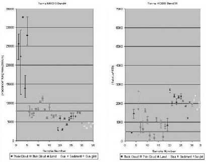
Figure 1. Statistic calculation of selected ROIs in MODIS reflective and emissive bands
2.4 Observation of Effective 2-band Combination for cloud detection
Another method of cloud detection is to combine both emissive (band 31) and reflective bands (band 1, 2, 3, 4, 6, 7, 17, 18, and 19). Figure 2 shows scatterogram of 100 ROIs plotted between reflective bands and emissive band. ROIs were selected in the same way as section 2.3.
The cloud ROIs are at the top left portion of the scatter gram, while clear areas are located at the lower right part. From the graph, linear threshold (y = ax + b) is applied between cloud and clear area. The areas which are lower than the threshold is consider as cloud-free.
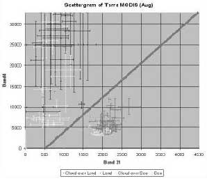
Figure 2. Scatterogram between band 31(X-axis) and Band4 (Y-axis)
2.5. Estimate cloud coverage probability over Indochina peninsular
By overlaying weekly cloud masked images, the cloudy pixels are added together and divided it by the total amount of images, and multiplied it by 100. We will finally obtain the percentage of existing clouds in the given location.
3. RESULT AND DISCUSSION
3.1 Cloud detection
Two sub scenes of Terra MODIS image received on 3 April 2003 at 3:50 GMT are chosen to give examples of cloud detection over land and sea. They cover the north east of Thailand and the Gulf of Thailand respectively.
Figure 3 and 6 show 2% linear enhanced radiance and brightness temperature. It can be seen that the bright tone of band 1, 3, 4, 6, 7, 17, 18 and 19 and the dark tone of band 31 and 32 are clouds.
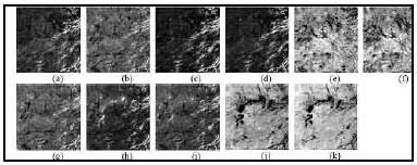
Figure 3. North-east Thailand by Terra MODIS: (a)-(k) are channels 1, 2, 3, 4, 6, 7, 17, 18, 19, 31, and 32
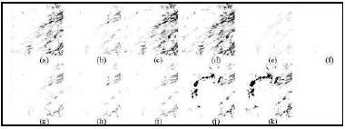
Figure 4. North-east Thailand by Terra MODIS: (a)-(k) Cloud detection result with black colored pixels on channels 1, 2, 3, 4, 6, 7, 17, 18, 19, 31, and 32
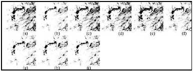
Figure 5. North-east Thailand by Terra MODIS: (a)-(i) Cloud detection result with black colored pixels on channels 1&31, 2&31, 3&31, 4&31, 6&31, 7&31, 17&31, 18&31, and 19 & 31.
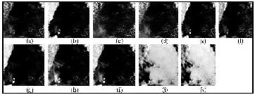
Figure 6. Gulf of Thailand by Terra MODIS: (a)-(k) are channels 1, 2, 3, 4, 6, 7, 17, 18, 19, 31, and 32
Figure 4 and 7 shows the results of one band threshold image of land and sea. Cloud-contaminated pixel was shown in black. For Bright cloud, band 1, 3, and 4 thresholds seem to correspond for the land case, while band 6 and 7 are well separated between bright cloud and sea, and Band 31 and 32 have defined separate darker lower clouds for both land and sea case. Figure 5 and 8 show the results of the cloud detection by two-band combination linear threshold for land and sea, respectively. The best band combination for land is the combination between band 4 and band 31. And the outcome of the band combination between band 6 and band 31 has the best result.
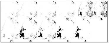
Figure 7. Gulf of Thailand by Terra MODIS: (a)-(k) Cloud detection result in black colored pixels on channels 1, 2, 3, 4, 6, 7, 17, 18, 19, 31, and 32
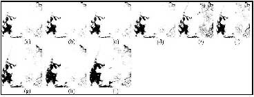
Figure 8. Gulf of Thailand by Terra MODIS: (a)-(i) Cloud detection result in black colored pixels on channels 1&31, 2&31, 3&31, 4&31, 6&31, 7&31, 17&31, 18&31, and 19&31
3.2 Evaluation of Cloud coverage for Indo china peninsula
Details of the seasonal variation of cloud coverage are illustrated by the percentage of cloud existence in each pixel. The number of scenes for Dry, Hot, and Rainy seasons are 12, 5, and 13 images, respectively. Hot season was excluded form this discussion because the limitation of the data.
For dry season, Figure 9(a) shows the influence of the monsoon wind direction interacting with the local topography. We obviously see that there are very high concentrations of cloud in the Northern part of Vietnam, the eastern shore of the lower south of Thailand, and the east coast of Sumatra Island. This is due to the orographic effects. Orographic effects occur when air encounter a mountain range.
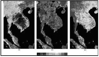
Figure 9. Images of Seasonal Terra MODIS cloud coverage over land: (a) Dry season, (b) Hot season, (c) Rainy season
For rainy season, figure 9(c) shows the high percentage of cloud coverage (above 50%) in the Indochina peninsula especially in the west coast. The moisture monsoon directly hit the exposed peninsula south. The lowest cloud coverage is in Korat Plateau surrounded by the mountain ranges. The percent could coverage is between 70 to 100 percent. For this reason, it is difficult to observe the land surface in the rainy season by Terra MODIS.
4. CONCLUSIONS
Two-band combination between emissive and reflective bands was used to separate the cloud-contaminated pixels from the cloud-free pixels. Linear thresholds of the band combination between band 4&31 and band 6& 31 are used to detect the clouds over land and sea, respectively. Presently, automatic cloud detection algorithm is not yet developed. We also evaluate seasonal cloud coverage. We found that the cloud coverage probability of Indochina Peninsula influenced by monsoon wind directions interacting with the location and terrain.
REFERENCES
- Ackerman, S., Strabala, K., Menzel, P., Frey, R., Moeller, C., Gumley, L., Baum, B., Seeman, S.W., Zhang, H. 2002 Discriminating Clear-sky From Cloud with MODIS, Algorithm Theoretical Basis Document (MOD 35).
- Li, J., Menzel, W.P., Yang, Z., Frey, R.A., Ackerman, S.A., 2003 High-spatial-resolution Surface and Cloud-Type Classification from MODIS Multispectral Band Measurements, Journal of Applied Meteorology, Vol. 42: 204-226,