| GISdevelopment.net ---> AARS ---> ACRS 2004 ---> Data Processing: High Resolution Data Processing |
An Object-Oriented
Classification Method on High Resolution Satellite Data
Sun Xiaoxia, Zhang Jixian,
Liu Zhengjun
Chinese Academy of Surveying and Mapping, No16,
Beitaiping Rd, Haidian District ,Beijing,
100039, China
Email: sun.xiaoxia@163.com
Chinese Academy of Surveying and Mapping, No16,
Beitaiping Rd, Haidian District ,Beijing,
100039, China
Email: sun.xiaoxia@163.com
To traditional moderate or low resolution satellite data, the data processing or information detecting is only on a per-pixel basis because of the impacts to geometric accuracy of spatial resolution, Thereby only the spectral information is used for the classification. High spatial resolution sensors involves a general increase of spatial information and the accuracy of results may decrease on a per-pixel basis. In order to realise the full potential of the VHR image data, An object-oriented image analysis is implemented with the software eCognition. It is based on fuzzy logic, allows the integration of different object featrues, such as spectral values, shape and texture. In this paper we analysis an object-oriented classification method using QuickBird panchromatic and multispectral data on the test area of the PuDong New district of ShangHai.The analysis includes two parts: first dividing the image data into segments and then classifying the segments by means of fuzzy approach of nearest neighbour classifier.
1. INTRODUCTION
With the development of satellite technologies,some very high resolution (VHR) satellite data whose metric characteristics are acceptable for large scale land use mapping has been produced. Traditional supervised classification and unsupervised classification are based on the grey value of pixel itself, that is to say, only the spectral information is used for classification. The result will be unacceptable when classifying the VHR image data. To solve this problem an object-oriented classification method utilizing image segmentation and fuzzy classification on the results of segmentation is suggested.
In this method, the processing units are no longer single pixels but image objects. Firstly, the complete image has to be segmented into meaning pixel groups ,namely segments. Secondly, A set of knowledge-based classification rules to describe each class should be define. The rules includes spectral, spatial, contextual, and textual information. And then, classifier will be choosen to assign each segment to the proper class according to the rules(Leukert,2004). Compared to conventional pixel-based classification approaches,utilizing only the spectral response, image objects contain additional information, like object texture,shape, relations to adjacent regions.The results of classification are advaced from pixel-basis to object-basis and the accuracy of auto recognition on VHR data is improved largely. This approach can validly satisfy the large scale land use mapping and investigations.
This paper starts with a short introduction of the object-based classification method. After pre-processing of Quickbird image data by EARDAS software, the practical segmentation and classification are implemented by eCognition, and at the last, a summary and a concluson is given.
2. OBJECT ORIENTED METHOD
In general, the object-oriented classification process can be divided into the two main workflow steps: multiresolution segmentation and fuzzy classification of the resulting image objects. Segmentation means the groups of neighbouring pixels into regions or segments based on the similar criteria such as scale,color and form. Multiresolution segmentation is the first and important procedure in the eCognition software.It allows the largely knowledge-free extraction of homogeneous image objects in any chosen resolution,especially taking into consideration local contrasts. The result of segments act as image objects which can be classifyied in next step.
eCognition offers two different classifiers: nearest neighbour and membership functions. Both act as class descriptors. The nearest neighbor classificatioon is similar to the supervised classification in common image analysis software. It also needs to choose train areas which are typical representatives of a class. In eCogniton the train areas are named as samples. When user has no knowledge to describe feature spaces, the nearest neighbor is the best choice. The membership function method are based on fuzzy logic of segment features to classify image objects. Fuzzy logic is a mathematical approach to quantify uncertain statements. Membership functions allow the formulation of knowledge and concepts. They are easy to adapt. Therefore, if a class can be separated from other classes by a few features or even only one feature, the use of membership functions is recommended. If you intend to use several object features for a class decription, the use of nearest neighbor as a classifier is advisable, because the overlaps in a multidimensional feature space can be handled much better by nearest neighbor than by membership functions.
3. STUDY AREA AND PRE-PROCESSING OF DATA
The study site is the PuDong New district of ShangHai in China. The test data include QuickBird panchromatic and multispectral data(see Figure1).

Figure 1. Quickbird panchromatic (left) and multispectral (right)
First of all, the panchromatic image was geo-referenced and then the other images were geo-referenced by using “image to image” technique. In order to benefit from high spatial resolution simultaneously with spectral information, Principal component transformation was applied to resolution merge (Marangoz, 2004). The first principal component of the four spectral Quickbird channels with 2.4 meter resolution was substituted by the 0.7 meter resolution Quickbird panchromatic channels. The results of combination then was re-transformed applying an inverse principal component transformation (see Figure2).

Figure 2. principal component transformation image
4. TEST RESULTS
Segmentations of meaning objects were implemented with merged image. By test, the scale parameter was defined as 50. The result of the segmentation was shown in Figure3.

Figure 3. Image segmentation
Before the classification, the classes were assigned and the classification rules to description each class were selected . According to the ground truth, four classes were distinguished in this test: vegetation, water, building, road, and another class shadow. The nearest neighbor classifier was used. The classification were completed in iterative steps. The first classificatin results were shown in Figure4. The results looks promising, but there is certainly a need for further improvement. We can notice that a relatively large number objects such as shadow, vegetation were classified as water. Therefore, the results needed to be corrected time after time by assigning typically wrongly classified image objects as samples to the right class, until the classification results were satisfying. The last classification results were shown in Figure5.
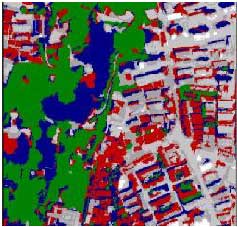
Figure 4. The first classification results
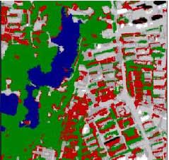
Figure 5. The last classification results
5. SUMMARY AND CONCLUSIONS
In this paper, new object-oriented image classification approach has been implemented using Quickbird panchromatic and multispectral data of shanghai test field. In order to utilize the spectral properties of VHR images, principal component analysis method can be used. By first with segmentation, then the fuzzy classification, eCognition software gives a satisfying classification, which show that the object-based image analysis method improves the accuracy of VHR image classification largely.
6. REFERENCES
- eCognition User Guide 4. 2004. http://www.Definiens-imaging.com. pp.6-7 ~ 6-14. pp7-4 ~ 7-5.
- Du, F. L., 2004. Object-oriented Image Classification Analysis and Evaluation, remote sensing technology and application, Vol.19, No.1, pp. 20~23.
- Leukert, k., 2004. Transferability of knowledge-based classification rules, ISPRS2004, Istanbul. Marangoz, A. M., 2004. Object-oriented image analysis and semantic network for extracting the roads and buildings from ikonos pan-sharpened images, ISPRS2004, Istanbul.
- Shataee, S., 2004. Forest types classification using ETM+ data in the north of Iran/comparison of object-oriented with pixel-based classification, ISPRS, Istanbul, 2004.