| GISdevelopment.net ---> AARS ---> ACRS 2004 ---> Data Processing: High Resolution Data Processing |
The Utilization of the Old
Technology in the High Resolution Satellite Image Management
Varisara Yasamuth,
Mrs.
Plan and Policy Analyst 6 th
Institute of Narcotic Crops Survey and Monitoring
Northern Narcotics Control Office
Office of the Narcotics Control Board, Thailand
Tel 66-53-211796-7 ext 140 Fax 66-53-211808
E-mail: varikeng@yahoo.com
Plan and Policy Analyst 6 th
Institute of Narcotic Crops Survey and Monitoring
Northern Narcotics Control Office
Office of the Narcotics Control Board, Thailand
Tel 66-53-211796-7 ext 140 Fax 66-53-211808
E-mail: varikeng@yahoo.com
ABSTRACT
Nowadays, the technology of remote sensing satellite is more advanced especially the pixel resolution. Many countries invent more of global observation satellites which their capacities of pixels are more clearly like almost touching the earth’s skin. The satellite which be called “high resolution satellite” might have the pixel resolution which begin from 5 meters down to less than 1 meter. The utilization and application of high resolution satellite images are more increased in many of the government bureaus. However, the high capacity of pixel resolution makes the high cost of expenses. Meanwhile, the technology of inventing the image processing software is developed for supporting the utilization of the high resolution satellite image. The similar effect of the high quality of pixel resolution satellite is the expensiveness of the software. The most important thing is that most of the government sections which work on this mission have limited budget to catch up with these new products and technologies. In this situation, the Office of the Narcotics Control Board (ONCB) by Narcotics Crops Survey and Monitoring Institute (NCSMI) try to use the old image processing software which has the limit of image processing functions and the experience concerned to create and improve the quality of high resolution satellite data for the specific mission, as the narcotic crop survey and following the drug situation in the target area. The result is well satisfied and can be used in the real situation. One more benefit of this result is that the real users especially the users who have no or little experience in image interpretation and the area background could easily learn and get the approach from the high resolution satellite image data. However, the old software of high resolution satellite image data still has some limits of image processing option in high resolution satellite data.
INTRODUCTION
The Office of the Narcotics Control Board (ONCB) applied satellite image data for surveying and monitoring the narcotic crop especially opium poppy for more than 20 years. Landsat and SPOT images were used and passed the process of image processing for improving the quality of data before being the database for interpreting opium fields. One important process for improving image data is the resolution re-sampling process. The benefit result is to enhance the data to be more clearly detail so that the result of opium poppy field interpretation is more accurately and the eradication is more efficiently. One more thing, the proper and available software of image processing at that time works well and support image data. Until 2003, the necessity of using the high resolution satellite image takes a high role especially in some specific areas where the medium satellite image data cannot give more clearly data. Meanwhile, the technology of inventing image processing software is more advanced to catch up with the high resolution satellite image. Both high resolution data and advanced software are very expensive especially for the governmental part like ONCB. However, ONCB tries to use the old software like EASI/PACE (version 6.1) and MULTISCOPE (version 2.41) with the high resolution satellite image: QUICKBIRD to study the capacity of the old software and the efficiency of the result. By the result of this study, it should be able to take some comments and some points for developing the methodologies of image processing to the high resolution satellite image in the future.
OBJECTIVE
- To study the capacity of the old software in managing the high resolution satellite image
- To get the efficiency of image data quality by comparing the result image from automatic fusion data
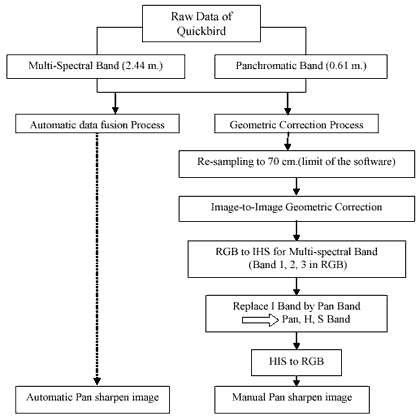
Figure 1 Methodology chart of procedure
RESULT/CONCLUSION
By using the old methodology of the different resolution image fusion with the old software, the output of the image is clear and displayed a lot of detail. Comparing the manual Pan sharpen image and the automatic Pan sharpen image, the manual Pan sharpen image displayed more natural color than the automatic Pan sharpen image. However, the limit of the old software is that it must take a long and complex step to get the good quality of image. In addition, there is a limit of software to permit the highest resolution in a panchromatic band which in the advanced software can merge or make the fusion with multi-spectral bands immediately. Furthermore, before importing the high resolution data, it must be transferred from 11 bit type to 8 bit type. All result of images is below.
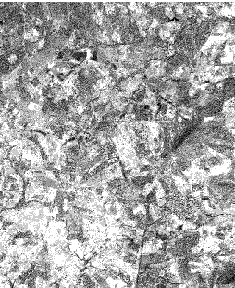
Raw QUICKBIRD PAN (61 cm.)
Raw QUICKBIRD MUL (2.44 m.)
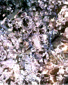
Automatic Fusion data: band 1, 2, 3 and Pan (61 cm.) in RGB
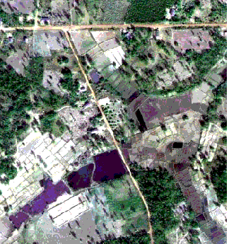
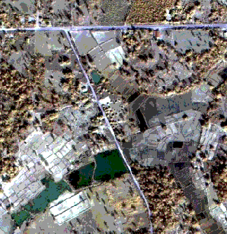
Manual fusion data: band 1, 2, 3 and Pan (70 cm.) in RGB