| GISdevelopment.net ---> AARS ---> ACRS 2004 ---> GPS & Photogrammetry: Digital Photogrammetry |
Finding True Position of
Buildings in Orthophotos
W. Wolniewicz PhD, P.
Jaszczak *
Institute of Photogrammetry and Cartography, Faculty of Geodesy and Cartography,
Warsaw University of Technology, Pl. Politechniki 1, Warsaw, Poland, 00-661
href="mailto:w.wolniewicz@gik.pw.edu.pl">w.wolniewicz@gik.pw.edu.pl, p.jaszczak@interia.pl
* Student of Faculty of Geodesy and Cartography, specialty Photogrammetry
ABSTRACT:
VHR images of earths’ surface are more frequently used and taken advantage of in substitution to aerial photographs. Geometric dependences of creation orthophoto based on aerial photos are known and distinguished from images of VHR. Results of work led are presented in this article within the confines of an investigative project under the Committee of Scientific Research of Poland concerning the geometric mechanism of VHR images and corrections. Two test fields have been made up for this project (flat – city, foothills terrain). For those test fields, images from IKONOS, QuickBird were ordered. For image geometric corrections in this project four types of available DTM models in Poland with various accuracy have been applied. In each test field area, after the identification of control points on the VHR images, about 30 – 100 GCPs have been measured with GPS in planimetric accuracy of 10 cm. Geometric correction have been realized with the aid of generally available software as PCI Geomatica 9 with taking into consideration RPC method and camera (rigorous) model. Throughout the work investigated, in each of the individual scenes of VHR various numbers of GCPs was utilized for the process of orthorectification. Accuracy of orthorectification process was received in result of led work for VHR images with influence of different type DEM used. Detailed results of experiments allow determining the optimal foundation for different methods of geometric corrections from IKONOS, QuickBird images and establishing effective process of dependence and defining geometric accuracy for different applications.
1. INTRODUCTION
In recent years we can observe rapidly increasing interest in the practical application of very high-resolution satellite imaging. The reasons are: from one side a need for satellite information about the surface of the earth to be applied in many different fields, and from the other side a need to achieve digital technologies optional to traditional photogrammetrical solutions (aerial photographs).
Poland is particularly interested in taking advantage of satellite imaging type VHR. This interest results mainly from an urgent need to cover the area of the country with such products as orthophotomaps, DEM or topographic database, in order to reach the same level of spatial digital data coverage as the countries of Western Europe. Therefore it is natural to see in VHR imaging a source of data quickly reaching this level of coverage. The project for creation of an orthophotomap of IKONOS images for an area of 50.000 sq kilometers, for the needs of LPIS (The Land Parcel Identification System program was initiated in 1995 as an alphanumeric identification system for all agricultural parcels in EU) is the practical manifestation of such interest in VHR imaging.
In order to verify practical applications of such imaging, research was conducted, which comprised generating satellite orthophotomaps achieved with a use of many different techniques in various circumstances for the same land areas, obtained from the most commonly used VHR systems, i.e. IKONOS-2 and QuickBird-2.
The goal of this research was to compare procedures and technologies how influence different DEM for producing orthophotomaps based upon the high-resolution satellite images for the selected testing area. There were two test fields: Warsaw as flat area, and Nowy Targ as foothills area of de-leveling up to 500 meters.. In the framework of investigations were providing accuracy evaluations of the achieved satellite orthophotomaps in different variants of geometrical correction. In this paper is presented detailed assessment of the planimetric accuracy of the panchromatic VHR images.
2. EXPERIMENT
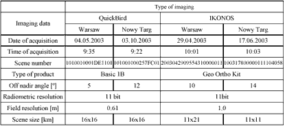
The scenes achieved by the systems IKONOS and QuickBird for different time slots and angle deflections were used for the survey. For flat area (Warsaw) the deflection from axis in relation to nadir point is 5 degrees for QuickBird (DigitalGlobe provided a test image acquired over Warsaw, Poland) and 10,5 degrees for IKONOS. At the same time for foothills areas (Nowy Targ) they are respectively 12 degrees for QuickBird and 14 degrees for IKONOS (INTA SPACTURK provided a test image acquired over Nowy Targ, Poland). Precise characteristics of the imaging used have been presented in Table 1.
In order to realize the process of ortho adjustment, we presumed a photogrammetrical matrix with the use of a GPS system. For determining coordinates of these points a TRIMBLE 4700 satellite dual-frequency receiver with Micro-centere antenna was used. The survey was done with a use of the faststatic method with an accuracy 0.1 m in the terrain for the values of x, y and 0.2 m of z. During the survey, the terrain points were documented with photographs, on which the terrain situation and survey position were visible. They were used together with photographic sketches for pointing out the GCPs on images (Figure 1).
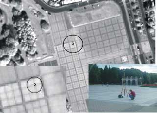
Figure 1. Projected identification and measurement of GCP on QuickBird imaging fragment
The process of determining future points to be used for correlation and for controlling mapping quality of the achieved points constituted a very important element. The point was to ensure possibly similar accuracy for all GCPs with identification on the imagery not worse than half pixel.
Thanks to the use of a GPS receiver for acquiring the points, all coordinates are of exactly the same accuracy of measurement, which considerably affects the result of adjustment. For ortho-adjustment we used four types of DTED (Digital Terrain Elevation Data) (Figure 2):
a) DTED Level 0 - produced by NIMA
b) DTED Level 1X - produced by SRTM
c) DTED Level 2 - produced in digitizing map 1: 50 000 (post spacing 25 m)
d) DTED Level 2X - produced in digitizing map 1: 25 000 (post spacing 10 m)
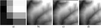
Figure 2. Comparison of used DTED: a) DTED Level 0, b) DTED Level 1X, c) DTED Level 2, d) DTED Level 2X
DTED Level 0 is a global digital elevation model produced by the National Imagery and Mapping Agency. It can be downloaded from the WWW. Digital Terrain Elevation Data Level 0 is in 30-arc second grid (1 kilometer). DTED Level 1x was created on basis of space shuttle (STS ) mission called Shuttle Radar Topographic Mission. During this a DTED in 1 and 3-arc second grid (approximately 30 and 90m) was created for 80% of earth surface with two antennas at 60 meters distance. It is possible that DTED produced on basis of SRTM will replace data today called as DTED Level 1. DTED Level 2 that was used in this experiment was produced in Poland based on digitizing maps 1:50 000 scale and post spaced to 25x25 meter grid. Polish army specialists additionally corrected its accuracy. DTED Level 2A was produced in digitizing 1:25 000 maps and post spaced to 10x10 meters grid.
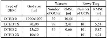
Using GCP points measured in terrain with GPS techniques for each DTED a RMS error was defined. A comparison of them is shown in Table 2.
3. PROCESSING
Ortho-adjustment processes were conducted using commercially available software: PCI Geomatica 9 including a module Ortho-Engine. This software enables the use of several methods of geometrical adjustment. In the framework of tests two methods were used.
Rational polynomial coefficient (RPC) method is the 3D model describing the relations land-image in form of polynomial quotient. “Firmware information” of mathematical relations in form of RPC coefficients is transferred within the image ordered. Terms of polynomial have no simple physical or geometrical interpretation connected with the parameters of camera of the image distortion factors, therefore it is called the “non-parametrical” model. These models take into account DEM height values for imaging terrain, and to a great extent they are free from the common disadvantages of polynomial coefficient transformations.
The Parametrical model (PM) describes actual relations between the land and its image, therefore the terms of this model have a precise geometrical interpretation. The basis for construction of the precise model for satellite imaging is the condition of co-linearity. In this point, however, it may be applied not to the entire image, but only to a single line. Parametrical models are less susceptible to photo-points distribution and possible errors in data.
In the framework of research we used PCI software, taking into consideration the approach of dr Th. Touitn from CCRS on parametrical relations for VHR type images. In the framework of survey conducted we presumed that the orthophotomap generated would be created in the “1992” Projection Gauss-Kruger, Spheroid GRS80, Datum ETRS89 system, hence all auxiliary data for this process, namely GCPs and DEM, had been previously transformed for this system. We also presumed that for accurate analysis of orthophotomaps created, only the VHR images in panchromatic range were used. We acquired orthophotomaps for imaging (QuickBird and IKONOS) with a use of the parametrical method (PM) (with use of a camera model) and the Rational Polynomial Coefficient (RPC) method, based upon PCI software. Uniform distribution of adjustment points for both methods was presumed. Figures 3-6 present a specification of acquired accuracy of generated orthophotomaps. Each figure presents the achieved accuracy of ortho-adjustment for a given sensor and type of terrain depending on a number of GCPs points
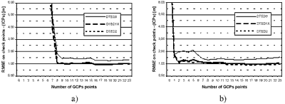
Figure 3. Accuracy of IKONOS for Warsaw area, parametric (a) and RPC (b) approach.
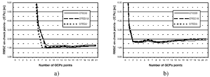
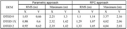
Figure 4. Accuracy of QuickBird for Warsaw area, parametric (a) and RPC (b) approach.
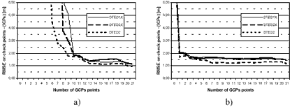
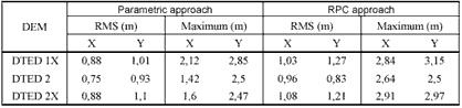
Table 5. Comparison of RMS and maximum errors over 24 ICPs of parametric model computation with 13 GCPs and over 28 ICPs of RPC computation with 9 GCPs
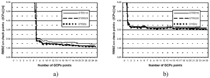
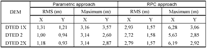
Figure 6. Accuracy of QuickBird for Nowy Targ area, parametric (a) and RPC (b) approach.
Achieved accuracy was checked on control points, which did not take part in the process of orthorectyfication . In the framework of each scene we checked upon the accuracy achieved on control points (ICP) in number of 20-90. These points were not used for adjustment process by possible support of DEM accuracy.
4. RESULTS AND ANALYSIS
Ortho-adjustment process was done for IKONOS and QuickBird data with parametric and RPC approach in PCI Geomatica program. Number of GCPs and received results for each of used DTED were presented in Figures 3 – 6. Each figure shows received accuracies of ortho-adjustment process for selected sensors and test fields. They were achieved on control points (ICP) that were not used in process. In range of each scene there were measured 30 – 100 points for ortho-adjustment process and its accuracy determination.
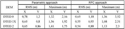
- For flat areas (Figure 3), with a use of DTED Level 1X and 2 for IKONOS images, method RPC enables achieving accuracy (RMS) of some 1-1.3 meter almost irrespectively of a number of GCPs used. Usage of DTED Level 0 enables results 0.5-1 meter worse. Parametrical method for this sensor requires a use of at least 8 GCPs in order to achieve nearly the same accuracy.
- In case of imaging achieved from QuickBird (Figure 4) (for the same conditions), RPC method gives accuracy (RMS) of about 2 meter, but with a use of minimum 2 GCPs. Applying PM for 8 GCPs we can obtain RMS nearly 1.3 meters. Influence of different DTED is very similar for parametric and RPC approach results.
- In foothills areas (of de-leveling some 500 meters) for IKONOS images, RPC method gives RMS of some 1.5 meter almost irrespectively from used DTED Level and number or GCPs. With a use of PM, minimum number of GCPs is 10, and it gives the same accuracy.
- For QB imaging, using a method type RPC, we can obtain RMS slightly above 3 meters with a use of at least 2 GCPs. At the same time, with a use of MP of minimum number of GCPs equal to 9, we can improve the accuracy even twice.
Commercial PCI software used enables VHR ortho-adjustment with the use of methods RPC and PM for different numbers of GCPs and available DTM, and to achieve accuracy in VHR ortho-adjustment process of nearly 1 meter. At the same time we have to be very strict when determining the following:
- For flat areas DTED Level 0 can be used to achieve ortho-adjustment results of 1.5-2 meters using both parametric and RPC approach for IKONOS and QuickBird images.
- DTED Level 2 and DTED Level 1X (SRTM) provides for flat terrain very similar results that are round 1 meter for QuickBird and IKONOS in both parametric and RPC approach.
- In areas with large de-leveling DTED Level 2 and 1X (SRTM) gives similar ortho-adjustment results using both methods and images.
- DTED Level 1X (SRTM) seams to be suitable for making orthophotomaps with RMSE 1.5 meters for all considered in this experiment terrains sensors.
- In both flat and large de-leveling terrains DTED Level 1X (SRTM) is accurate enough for orthorectification VRH satellite images.
- For making ortho-adjustment of VHR data it is most important to assure a high precision GCPs identification, interpretation and measurement in terrain and on the image.
The authors thank INTA SPACTURK and European Space Imaging for providing IKONOS images, DigitalGlob for providing the QuickBird images and European Commission Joint Research Center for providing SRTM data, respectively to do research in Poland.
7. REFERENCES
- Davies C.H., X. Wang, 2001. Planimetric Accuracy of IKONOS 1-m Panchromatic Image Products, Proceedings of the 2001 ASPRS Annual Conference, St. Louis, MI .USA, April 23-27, CD-ROM.
- Jacobson, K., Passini, R. 2003. Accuracy of Digital Orthophotos From High Resolution Space Imagery, Proceedings of the Workshop High Resolution Mapping from Space 2003, Hannover 2003.
- Jacobson, K., Passini, R. 2003. Comarison of QuickBird and IKONOS for the Generation of Orthoimages, ASPRS Annual Convention, Anchorage, 2003, on CD.
- Toutin Th., 2001, Geometric processing of IKONOS Geo images with DEM, ISPRS Joint Workshop "High Resolution Mapping form Space", Hannover, Germany, September 19-21, CD-ROM, pp. 264-271.
- Toutin Th., R. Chénier and Y. Carbonneau, 2001, 3D Geometric modelling of IKONOS Geo images, ISPRS Joint Workshop "High Resolution Mapping form Space", Hannover, Germany, September 19-21, CD-ROM, pp. 272-280.
- Toutin Th., R. Chénier, Y. Carbonneau and N. de, 2002, 3D mapping with high-resolution images, 22nd EARSeL Symposium "Geoinformation for European wide integration", Prague, Czech Republic, June 4-6, CD-ROM.
- Toutin Th., R. Chénier, Y. Carbonneau and N. de, 2002, 3D Models for High-resolution Images: Examples with EROS, IKONOS and QuickBird, Int. Archives of ISPRS Symposium, Comm. IV, Ottawa, Ontario, Canada, July 8-12, Vol. 34, Part 4, pp. 547-551.
- Toutin, Th., 2002, Error tracking in IKONOS geometric processing using a 3D parametric modelling, Photogrammetric Engineering and Remote Sensing, 68, 9p.
- Wolniewicz W., 2004, “ Assessment of VHRS images “ Euroimage Meeting , Roma Wolniewicz W., 2004, “ Assessment of Geometric Accuracy of VHR Satellite Images” XX ISPRS Congress, Istanbul, on CD-ROM