| GISdevelopment.net ---> AARS ---> ACRS 2004 ---> Data Processing: Data Fusion |
Classification of
Polarimetric SAR imagerary based on Target Decomposition and neural
network classifier
CHEN Jin Song 1,2 , SHAO
Yun 1 , LIN Hui 2
(1.Institute of Remote Sensing Applications, Chinese Academy of Science, Beijing 100101, China)
(2. Joint laboratory for geoinformation science,Esther Li Bldg.,Rm615,Chung Chi college
The Chinese university of Hong Kong, Shatin,N.T., Hong Kong)
Email: chenjinsong@cuhk.edu.hk
(1.Institute of Remote Sensing Applications, Chinese Academy of Science, Beijing 100101, China)
(2. Joint laboratory for geoinformation science,Esther Li Bldg.,Rm615,Chung Chi college
The Chinese university of Hong Kong, Shatin,N.T., Hong Kong)
Email: chenjinsong@cuhk.edu.hk
Abstract
Based on SIR-C data of He Tian prefecture in Xinjiang of China, in this paper we first use Cloude’s target decomposition theory to decompose the SIR-C data into three no-related scattering components: an odd number of reflections, aneven number reflections, and a cross-polarized scattering power, which represent different scattering mechanism of ground objects. And then we employ neural networks classifier to classify the SIR-C images using the decomposed images with polarimetric synthesized total power image and scattering entropy . The decomposition result shows that the decomposed three scattering components could reflect the correct scattering feature . The classification result shows that the method can effectively extract information of land cover , achieve the better classification accuracy of ground objects and improve the ability of polarimetric SAR to monitor the land use and cover.
I. INTRODUCTION
Development in microwave technology have promised an improved measurement capability, allow the operation of SAR imaging system of multiple frequency and polarization. In addition,. all-weather ,day and night operation and the ability to penetrate foliage or surface features, give microwave radar advantages over optical imaging system. To make most of collected SAR data, and to reduce the requirement for image interpretation , a quantitative procedure for systematic classification is needed.
The achievements of SAR-based earth terrain classification have progressed rapidly in recent years using data from airborne and satellite radar system. Polarimetric SAR measures the scattering matrix of each pixel on ground and can synthesizes the image at given orientation and ellipticity angle , including linear and elliptical polarization. It has many advantages over single or multi-polarization SAR in detecting objects, identifying targets and extracting texture .There have been developed several algorithms for the classification of land features based on their polarimetric microwave signatures.[1-7]. These methods exploit observed similarities and correlations in feature vectors derived from either complete coherent scattering matrix data or noncoherent multiple channel radar cross section data. Most of such classification algorithm are often grouped into supervised and unsupervised approaches, the classification result of which based on a statistical decision. But different ground targets often have the same polarization signal characteristics because of the complexity of the backscattering behavior of the ground targets, which leads to wrong interpretation of the images and identification of the targets. Besides, relatively high correlation of the synthesized polarized images often lead to poor accuracy of classification. So how to improve the classification of terrain cover using polarimetric SAR data has been an area of considerable interest and research.
In the analysis of polarimetric SAR data ,we often need to retrieve some geophysical parameters from an area that exhibits significant natural variability in the scattering properties. In such case, the resulting average stokes or covariance matrix differs considerably from that of a single scatter because of the combination of several scattering mechanism . I f we can find a way to decompose such an complex average stokes or covariance matrix into a sum of matrices representing single scatter, we would not only be able to more accurately interpret the scattering processes, reduce the residual information in the polarimetric SAR data, but the problem of retrieving geophysical parameters from the measured radar data would be dramatically simplified.[8-9].
In this paper , we first introduce the process of Cloude’s target decomposition[8] . Based on SIR-C data of He Tian prefecture in Xinjiang of China, we use target decomposition theory to decompose the data into four no-related scattering components; and then we use supervised back propagation neural network classifier to classify the combination of the above four data component and polarized synthesized total power image of the SIR-C (HH+2HV+VV). Finally we make simple analysis of the classification result. The result show that this method can obtain better classification accuracy and is helpful to the extraction of ground parameters using polarimetric data. II .Cloude’s target decomposition.
There have developed many target decomposition methods based on the measured scattering matrix. The advantage and disadvantage of these methods have been analysized in [8]. In 1988, Cloude proposed atarget decomposition based on an eigenvector decomposition of the target covariance matrix. This decomposition was shown to be unique and ,in the monostatic case, break the average covariance matrix up into the weighted sum of three covariance matrices representing three different single scatters, which are orthogonal to each other.
According the Cloude’s target decomposition[8], the target covariance can be expressed in this way:
In order to measure the randomness of target, Cloude’s target decomposition presents the definition of target entropy:
As showed by Cloude, the target entropy is a measure of target disorder, with H=1 for random targets and H=0 for simple(single) targets. In [] the research result has showed that the components of odd number of reflections, even number of reflections and cross-polarized returns are closed related to different types of ground targets and scattering mechanism respectively, such as even number of reflections corresponding t o a double reflections in forest area. Thus, we can improve the identification of ground targets by decomposing complicated scattering matrix of ground target into a combination of certain single mechanism using Cloude’s target decomposition, and measure the complexity of randomness of a scattering object using entropy value. III .SIR-C data decomposition and classification .
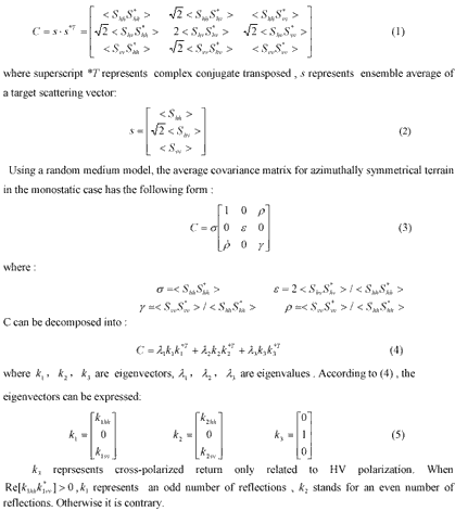
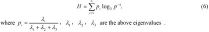
In this paper we take SIR-C data(L band) of He Tian prefecture in Xinjiang of China as example to show the application of Cloude’s target decomposition in classification of polarimetric SAR data. The characteristics of SIR-C data has been described in many literature. The test site is located in northwest china’s province Xingjinang . The ground target consist of bare soil, forest ,building , short shrub and grass and dry river bed. Through target decomposition ,we get the decomposed images and entropy image :
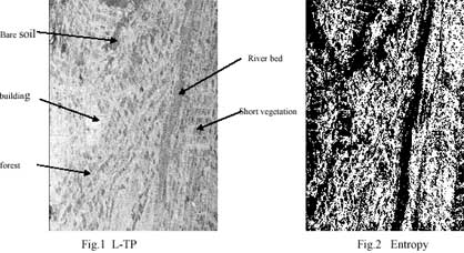
Fig.3 Decomposed components
Based on the land use map of test site , We can analysize the applicability of Croude’s target decomposition :
(1) In Fig.2, The entropy value of building and bare soil is very low , while that of forest and short vegetation is relatively high . The behavior of back scattering of building and bare soil is similar to that of single scatter, so they have low entropy value . That of forest and soil is contrary. The result agrees with the scattering mechanism of these grounds objects and assumption of Cloude’s theory very well.
(2) In Fig.3 a, Building , bare soil , dry river bed are similar to a single scatter, so they have high value of odd number reflection; Short vegetation is also near to small coarse surface under L band wave(24cm wavelength), which lead to relatively high value of odd number reflections. That of forest is contrary. The result also conform to assumption of Cloude’s theory very well.
(3) In fig.3 b and c , The area of forest and short vegetation has high value of even number reflection and cross-polarized returns, building and bare soil is contrary. According to the above simple analysis, Cloude’s target decomposition can correctly reflect the scattering mechanism of ground objects. What is more, the components from decomposition are not related, which could improve the accuracy of classification.
In this paper we select back propagation neural network classifier. The advantage of this classifier over other classifiers has been described in [3]. We obtained the classification result.
C1 is the classification result of conventional HH+VV+HV , c2 is that of Cloude’s target decomposition. We can use distance factor and Kappa factor to measure the result of classification :
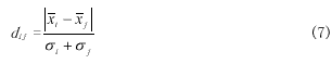
where Xi is the average vector of a certain class, ó i is the standard deviation of the class. The greater the dij , the better the separatabilty of two class.
(2) Kappa factor
The kappa factor is a measure of classification result. The greater the kappa factor, the better the classification result.
The following two table show the comparison of the two classification :

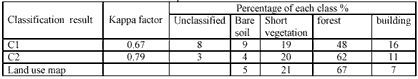
As shown in the above tables , Cloude’s decomposition enhance the separatabilty of classes and improve the classification result.
IV . CONCLUSION
In this paper we applied Cloude’s target decomposition to classification of polarimetric SAR. The result have shown that the target decomposition can help the interpretation of scattering mechanism of different ground target and improve the efficiency of application of polarimetric SAR in land cover. The neural network classifier can also be used to classification of polarimetric SAR . But the accuracy of this method of classification still has the room for improvement . Further work will concentrate on better understanding of target decomposition and finding more efficient and correct decomposition of covariance matrices of polarimetric SAR data., and how to apply the target decomposition to retrieval of geographic parameters is also the part of further work.
References
- J.A.Kong, S.H.Yueh, R.T.Shin, and J.J.van Zyl, “Classification of Earth Terrain Using Polarimetric SAR Images,” PIER, J.A.Kong, ED. New York: Elsevier, vol.3, ch.6, 1990
- H.A.Zebker, J.J.van Zyl , S.L.Durden, and L.Noriken, “ Calibrated imaging radar polarimety: Techniques examples and applications”, IEEE Trans. Geosi. Remote Sensing, vol.29, pp.942-961,1991.
- Y.Hara, R.G. Atkins, et al., “ Application of neural netwoks to radar image classification,” IEEE Trans. Geosi. Remote Sensing, vol.32, pp.100-110, Jan. 1994
- E.Pottier, “ On full polarimetric target decomposition theorem with application to classification and identification of real target cross section,” in Proc. Int. Radar Conf., Paris, France, May.1994, pp.330-335
- J.S.Lee and M.R.Grunes, “ Classification of Multi-look polarimetric SAR imagery based on the complex Wishart distribution,” Int.J.Remote Sensing , vol.15, no.11, pp.2299-2311,1994
- J.J. van Zyl and C.F.Burntte,” Bayesian classification of polarimetric SAR images using adaptive a-priori probagilities,” Int .J.Remote Sensing, vol.13, pp. 835-840,1992
- Shane Robert Cloude and Eric Pottier, “An Entropy based classification scheme for land applications of polarimetric SAR”, IEEE Trans. Geosi. Remote Sensing, vol.32, pp.100-110, Jan. 1994
- J.J.van Zyl, “ Application of Cloude’s target decomposition theorem to polarimetric imaging radar data,” SPIE, Radar Polarimetry , vol.1748, pp.184-212, 1992
- Shane Robert Cloude and Eric Pottier,’A Review of Target Decomposition Theorems in Radar Polarimetry”, IEEE Transaction on Geoscience and Remote Sensing, 1990, Vol.34, No. 2, p337-348