| GISdevelopment.net ---> AARS ---> ACRS 2004 ---> New Generation Sensors and Applications: Digital Camera |
Application of Digital Camera
Data for Air Quality Detection
H. S. Lim 1 , M.
Z. MatJafri 2 , K. Abdullah 2 , Sultan AlSultan
3 and N. M. Saleh 4
1 Student, 2 Assoc. Prof. Dr., 4 Mr. School of Physics,
University of Science Malaysia,
11800 Penang, Malaysia
Email: mjafri@usm.my, khirudd@usm.my
Tel: +604-6533888, Fax: +604-6579150
4 Dr., Al Sultan Environmental Research Center. Al Madina Rd., P.O.Box.
242 Riaydh Al Khabra, Al Qassim, Saudi Arabia.
Tel: +966504890977, Fax: +96663340366
Email: allssultan7@hotmail.com
ABSTRACT
Air pollution problem becomes increasingly critical in this present-day, whether in the developed or developing countries. Air management is one of the important issues in this 21st century. Malaysia is also affected by this problem. The new finding and analysis reported in this study provide a new perspective of air quality detection. It can provide information highly useful for real-time modelling of air quality. The objective of this study was to test the potential uses of digital camera imageries for air quality detection. In-situ measurements of corresponding air pollution parameters were carried out at the air pollution stations in Universiti Sains Malaysia, Penang. They were particulate matter less than 10 micron (PM10) and CO. A semi-empirical relationship has been developed between PM 10 and CO readings and the reflectance values recorded in visible bands by a normal digital camera. The digital camera imageries were separated into three bands assigned as red, green and blue bands for multispectral algorithm analysis. The best models were chosen based on the highest correlation coefficient, R 2 and lowest root mean square error, RMS for PM10. This study indicated that the digital camera imagery was capable of air quality estimation using remote sensing technique.
1.0 INTRODUCTION
When the first measurements of high concentrations of CO over tropical Asia, Africa, and South America were made available by the MAPS (Measurement of Air Pollution from Satellite) instrument launched in 1981 on the space shuttle Columbia (1), it became clear that air pollution was an international issue. Some studies showed that satellite data could be useful for revealing climatic and environmental implications of global air pollution (Akimoto, 2003). PM 10 was chosen as air quality parameter in this study.
But the main drawback of satellite images is the difficulty in obtaining cloud-free scenes especially at the Equatorial region. This problem can be overcome by using airborne images. In fact, air quality can be measured using ground instrument such as air sample. But these instruments are quite expensive and limitation number of the air pollutant station of each area. So, they cannot provide a detail spatial distribution of the air pollutant over a city. Several studies have shown the possible relationships between satellite data and air pollution [Weber, et al., (2001) and Ung, et al, (2001)].
The objective for this study was to test the use of a normal digital camera for air quality detection. In-situ measurements of corresponding air pollution parameters were carried out at the ASMA (Alam Sekitar Malaysia Sdn. Bhd.) air pollution station in Universiti Sains Malaysia, Penang. They were needed for the analysis algorithm calibration. Only two-air quality parameters were used in this study namely PM10 and CO. Various types of algorithm were tested and the accuracy were noted.
2.0 STUDY AREA
The selected air quality station was located in USM campus at longitude of 100 0 17.864’ and latitude of 5 0 21.528’ (Figure 1). The site consists mainly of undulating land has many assets that make it an ideal University campus. University Sains Malaysia is situated in the northeast district of Penang island (Figure 1).
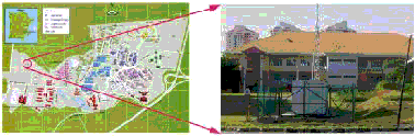
Figure 1 Study area and Air Quality Station
3.0 METHODOLOGY
The digital images were captured for a period of five days from 8-7-2004 until 11-7-2004 starting from 9.00 am. to 5.00 p.m. This air pollution station was selected in this study due to several reasons, 1. It is in the USM campus, so it is easy to capture the digital images hourly. 2. The presence of a construction site near the station, so we expected that the PM10 level to be high during working time. 3. The USM bus stop was near to the station, so we expected that the CO levels to be high during busy times in the morning and evening. 4. A building near the station can be used to stick up the colour paper on its wall for reference surface. The air quality station belongs to ASMA is shown in Figure 1. The digital images were captured hourly because the air quality data were also collected hourly by ASMA through the network.
We used a red colour paper and the wall of the building as our reference targets. The camera axis was at 90 0 with the plane the red colour paper. We captured the digital images of the reference targets by using the digital camera at near and far distances from the targets. The far distance between the building and the camera was 100 meter. The air pollution station was located between the reference target and the digital camera.
In this study a modification was made to the model developed by Ahmad and Hashim (1997). Skylight is an indirect radiation, which occurs when the radiation from the sun being scattered by elements within the air pollutant column. It is not a direct radiation, which is dominated by pixels on the reference surface. Figure 2 shows electromagnetic radiation path propagating from the sun towards the digital camera penetrating through the air pollutant column. (Source: Modified after Ahmad and Hashim, 1997).
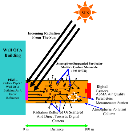
Figure 2 The skylight parameter model (Source: Modified after Ahmad and Hashim, 1997)
The modified model is described by:
4.0 DATA ANALYSIS AND RESULTS
The PCI EASI/PACE version 6.2 digital image processing software was used in all image-processing analysis. The digital images were separated into three bands (red, green and blue). The digital numbers were extracted and determined for each band.
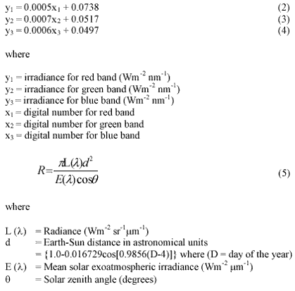
The average DNs were converted to irradiance using the digital camera coefficient calibrated by Lim, (2003) for each band. The irradiances were then converted to reflectance using the Equation 5 for each band. The solar angles and Earth-Sun distance were calculated corresponding to the time of acquisition of the digital images. Mean solar exoatmospheric irradiances used in this study were 1555 Wm -2 mm -1 , 1843 Wm -2 mm -1 and 1970 Wm -2 mm -1 for red, green and blue bands respectively.
All the reflectance values recorded by the digital camera was normalized to a reference time (10.00 a.m. on 8-7-2004 in this study) and subtracted by the reflectance of the reference target.
Table 1 shows the algorithm calibration coefficient obtained using the generated algorithm.
The calibrated digital camera coefficients are
After that, the reflectance recorded by the digital camera was subtracted by the reflectance of the known surface (equation 1). In this study, we assume that the lowest reflectance value recorded by digital camera (not affected by the atmospheric effect) was the reflectance of the known surface. The relationship between the reflectance values and the corresponding air quality data for the two pollutant parameters were determined using regression analysis. The plot of the relationships between the reflectance for each channel and the PM10 values is shown in Figure 3 and for the case of CO, it is shown in Figure 4. Other forms of algorithm were tested with the data set. For each regression model the correlation coefficient, R, and the root-mean-square deviation, RMS, were noted. The best models were chosen based on the highest correlation coefficient, R 2 and lowest root mean square error, RMS for PM10 and CO. Table 1 shows the comparative performance of the algorithms. The proposed algorithm produced the highest correlation coefficient between the predicted and the measured TSS values and lower RMS value compared to the other algorithms. With the present data set, the R and RMS values produced by PM10 were 0.7077 and 7.3784 mm/m 3 respectively (Figure 5). The R and RMS values produced by CO were 0.6901 and 0.1146 PPM respectively (Figure 6).
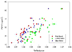
Figure 3 Graph of PM10 versus reflectance values
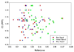
Figure 4 Graph of CO versus reflectance values
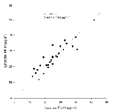
Figure 5 Relationship between measured
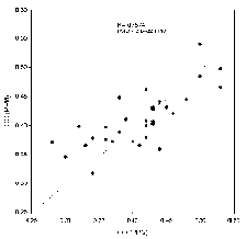
Figure 6 Relationship between measured and CO (PPM) estimated and estimated PM10 ( mg/m 3 )
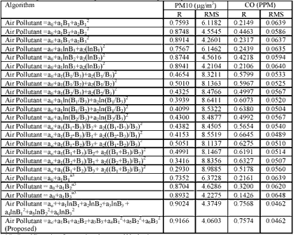
* B1, B2 and B3 are the reflectance for red, green and blue band respectively
5.0 CONCLUSION
This preliminary analysis indicated that digital camera imageries could provide useful remotely sensed data for air pollutant measurement using a multiband algorithm. In this study, digital camera imageries produced good results for mapping PM10. This proposed technique offers an alternative low cost remote sensing approach for mapping environmental atmospheric pollution. The result for the CO was not good in this study, because CO is colourless gas (State of Oregon, Department of Environmental Quality, 2003). The digital camera captures images based on colour of the targets. Further study will be carried out to increase the digital camera capacity for estimating the air quality.
ACKNOWLEDGEMENTS
This project was carried out using the Malaysia Government IRPA grant no.08-02-05-6011 and USM short term grant FPP2001/130. We would like to thank the technical staff who participated in this project. Thanks are extended to USM for support and encouragement.
REFERENCES
- Akimoto, H. 2003, Global Air Quality and Pollution, state of the Planet, 14 Nov – 5 Dec 2003. [Online] available: http://www.jamstec.go.jp/frsgc/whatsnew/2003/12_global/science_Akimoto.pdf. Asmala Ahmad, Mazlan Hashim, 2002, Determination of haze using NOAA-14 AVHRR satellite data, [Online] available: http://www.gisdevelopment.net/aars/acrs/2002/czm/050.pdf
- Lim, H. S., 2003, Total Suspended Solids Mapping Using Digital Camera Imagery Taken From Light Aircraft. M. Sc. Theses, Unpublished.
- State of Oregon, Department of Environmental Quality, 2003, Vehicle Emision Testing Using A Remote Sensing Device (RSD), Vehicle Inspection Program Report, [Online] available: http://www.deq.state.or.us/aq/vip/data/remotesensingreport2003.pdf.
- Ung, A., Weber, C., Perron, G., Hirsch, J., Kleinpeter, J., Wald, L. and Ranchin, T., 2001a, Air Pollution Mapping Over A City – Virtual Stations And Morphological Indicators. Proceedings of 10 th International Symposium “Transport and Air Pollution” September 17 - 19, 2001 – Boulder, Colorado USA, [Online] available: http://www-cenerg. cma.fr/Public/themes_de_recherche/ teledetection/title_tele_air/title_tele_air_pub/air_polluti on_mappin.
- Weber, C., Hirsch, J., Perron, G., Kleinpeter, J., Ranchin, T., Ung, A. and Wald, L. 2001, Urban Morphology, Remote Sensing and Pollutants Distribution: An Application To The City of Strasbourg, France. International Union of Air Pollution Prevention and Environmental Protection Associations (IUAPPA) Symposium and Korean Society for Atmospheric Environment (KOSAE) Symposium, 12 th World Clean Air & Environment Congress, Greening the New Millennium, 26 – 31 August 2001, Seoul, Korea, [Online] available: http://www-cenerg.cma.fr/Public/themes_de_recherche/ teledetection/title_tele_air/title_tele_air_pub/paper_urba n_morpho.