| GISdevelopment.net ---> AARS ---> ACRS 2004 ---> New Generation Sensors and Applications: Hyperspectral Sensing |
HY-1 satellite and its
application in China
Jiang Xingwei, Lin Mingsen,
Liu Jiangqiang
National Satellite Ocean Application Service, SOA, China
No.8 Da Hui Si Road, Hai Dian District, Beijing, China, 100081
Email: mslin@mail.nsoas.gov.cn, xwjiang@mail.nsoas.gov.cn, jqliu@mail.nsoas.gov.cn
National Satellite Ocean Application Service, SOA, China
No.8 Da Hui Si Road, Hai Dian District, Beijing, China, 100081
Email: mslin@mail.nsoas.gov.cn, xwjiang@mail.nsoas.gov.cn, jqliu@mail.nsoas.gov.cn
Abstract
The Chinese first Ocean satellite (HY-1) is an experimental and operational satellite for detecting ocean color and sea surface temperature. It was successfully launched on 15 May, 2002. The payloads on satellite include a 10-band Chinese Ocean Color and Temperature Scanner (COCTS) and a 4-band CCD imager. There are two ground stations composed the HY-1satellite ground application system in Beijing and Sanya. HY-1 satellite is the beginning of a new era of china’s ocean remote sensing and also ended the history of no ocean-satellite in China. It has operation near two years and used widely for marine environmental monitoring. This paper introduced the HY-1 Satellite, ground application system, operation and its application.
1. Introduction
The HY-1 satellite was successfully launched on 15 May 2002[1]. Ground stations in Beijing and Sanya, on 29 May, received the first orbit images. After in-orbit testing and process, we obtain ocean-color data for primary production, coastal zone changes and environmental monitoring of the China Sea.
2. HY-1 satellite characteristics and ground system
2. 1 satellite characteristics
The main use of HY-1 is to detect the marine environmental parameters of the China Seas, including chlorophyll concentration, suspended sediment concentration, and dissolved organic matter, pollutants, as well as sea surface temperature. The satellite will play an important role in developing and utilizing the marine bio-resources, constructing and managing the harbor, detecting the ocean pollution, investigating and developing coastal resources and studying the global environmental changes.
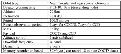
HY-1 satellite main characteristics are listed in table 1:
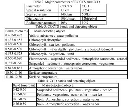
There are two sensors on the HY-1 satellite, the COCTS is an optical radiometer to detect ocean color and surface temperature. COCTS has a function to detect the amount of chlorophyll and dissolved substances in the water, and temperature distribution. The data of COCTS will be used to get the information of ocean conditions for fishery and environment monitoring. Its repeat period is 3 days. There are 8-channel visible and near-infrared band and 2-channel thermal infrared band with the spatial resolution of 1.1km. The CCD is a medium spatial resolution optical sensor for observing ocean color, land and coastal zones. CCD has 4 spectral bands from 0.42-0.89µm with spatial resolution of 250m. The CCD data will be used for regional mapping of different water constituents and vegetation, monitoring pollution of coastal zones for resource exploration etc. Its repeat period is 7 days. The main characteristics are summarized in table 2. 3. 4.
2.2 The ground system
The HY-1 satellite ground system consists of components for data receiving and preprocessing, data processing, data archiving and distribution, calibration and validation, communication, operation control and application and demonstration subsystem. NSOAS is responsible for marking the satellite observation schedule, real-time receiving and processing archiving and distribution of HY-1 satellite information products for marine environmental parameters forecast operational.
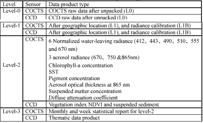
There are four Level data product types after processed for HY-1satellite as table 5
3. Applications and product show

Figure 2. HY-1 COCTS three-day mosaic image of the Beijing and Sanya ground stations of Jan.14-16,2003, (R/ch6,G/ch8, B/ch2)
Since May 2002 HY-1 satellite has monitored large sea areas of China, the Pacific, Indian, Atlantic and Arctic oceans, as well as the North and South poles. Two ground stations have got about 1700 orbit passes (3 passes each day). The coverage of the Beijing and Sanya ground stations as figure 2. These remote sensing imageries cover different sea areas and inland surface present so abundant coastal features, morphology and marine information, bright and gorgeous rivers, lakes and seas as well as various land vegetations. After the delivery of HY-1, the National Satellite Ocean Application Service carried out a great number of application work according to the properties of the two sensors on the satellite. Among them, distributed data processing system was studied; more than 40 quantitative satellite remote sensing products including chlorophyll, suspended sand, sea surface temperature, vegetation index were developed. Application service projects such as studies of ocean fisheries, marine primary productivity, monitoring of red tide, sea surface temperature, and sea ice and coastline variation were fulfilled.
(1) Ocean Color parameter
We have got Chlorophyll-a average distribution and four seasons change from COCTS level-2 product. Figure 3 shows Chlorophyll-a average distribution in China's sea area.
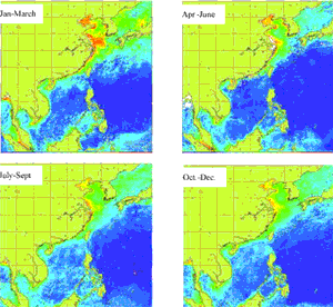
Figure3. Chlorophyll-a average distributions in China's sea area in four seasons 2003
(2) SST
We can get SST from COCTS channel 9 and Channel 10, and we can also get the SST distribution and change
(2) Sea Ice
The Bohai Sea covered with ice from December to March every year. The maximum extent of sea ice generally occurs in January and the typical thickness is less than 50cm. Sea ice threatens oil platform operation and the ship transportation. A variety of sea ice parameters, such as ice extent, thickness, concentration and image was extracted from visible and infrared channel of NOAA and GMS operational satellite in the past. During the winter of 2002~2003, the data of the HY-1 were applied to the sea ice monitoring and forecasting for the Bohai Sea of China for the first time[3]. The sea ice retrieve system of the HY-1 has been constructed. It receives 1B data from the satellite, outputs sea ice images and provides digital products of ice concentration, ice thickness and ice edge, which can be used as important information for sea ice monitoring and the initial fields of the numeric sea ice forecast and as one of the reference data for the sea ice forecasting verification.
The CH 5, 6 of COCTS are chosen for detecting cloud after experiment, and we get there are inflection points at about 25% albedo of COCTS CH 5 and at about 27% albedo of COCTS CH 6. These two points can be used as the threshold values to distinguish ice and cloud for COCTS, Similar to COCTS, the CCD CH 1 and 3 are both used for detecting cloud. If its albedo of COCTS CH 5 is greater than 14.0%, it is identified as ice. If its albedo of CCD CH 2 is greater than 12.6% or that of CCD CH 4 is greater than 5.8%, it is identified as ice. The method of piecewise linearity is used to calculate ice thickness. Albedo values corresponding to several certain ice thickness values are obtained from experiments. Then the piecewise linear interpolation is used to generate the relationship between all the values of albedo and ice thickness [2, 3], the result as below:
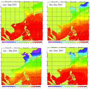
Figure4. SST average distributions in China's sea area in four seasons 2003
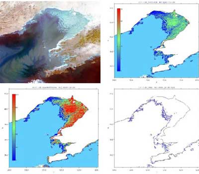
Figure 5. The sea ice image and ice thickness, concentration, edge distribution from CCD
(3) Other applications
There many other application about HY-1 satellite data, such as red tide and estuary monitoring: Sediment distribution.
4. Conclusion
HY-1 satellite is the beginning of a new era of china’s ocean remote sensing and also ended the history of no ocean-satellite in china, it has run about two years and used widely for marine environmental monitoring. We will continue to develop Chinese own ocean satellite and utilize other satellites as much as possible; we will also promote international cooperation in remote sensing for globe environment problem.
References
- HUANG Runheng, WANG Qiang, JIN Zhengang. 1992. Application of satellite imagery to monitoring of sea ice motion in northern China seas, Advanced Space Research, 12(7): 163-167
- JIANG Xinwei, LIU Jianqiang, LIN Mingsen. 2002. China HY-1 satellite and its ground application system, Satellite Application, 10(3), 23-29 (in Chinese)
- LUO Yawei, WU Huiding, ZHANG Yunfei, SUN Congrong,LIU Yu , Application of the HY-1 Satellite to Sea Ice Monitoring and Forecasting, Acta Oceanological Sinica, (in press)