| GISdevelopment.net ---> AARS ---> ACRS 2004 ---> Data Processing: Automatic Feature Extraction |
Automatic Precision
Correction of Satellite Images using the Chips of Different Resolution
Yong-Jo Lim*, Moon-Gyu
Kim*, Taejung Kim**, Seong-Ik Cho***, Song-Og Park*, Ji-Hyun
Shin*
Satellite Technology Research Center/ Korea Advanced Institute of Science and Technology *
373-1 Kusung-dong, Yusong, Taejon, Korea 305-701*
Tel: (82)-42-869-8629, Fax: (82)-42-861 0064*
E-mail: yjim@satrec.kaist.ac.kr, mgkim@satrec.kaist.ac.kr *
Dept. of Geoinformatic Engineering, Inha University**
Telematics Research Division, Electronics and Telecommunications Research Institute***
ABSTRACT
Precision correction is the process of geometrically aligning images to a reference coordinate system using GCPs(Ground Control Points). In general GCP is collected manually, using digital map, field survey (GPS surveying), rectified satellite image, and so on. In this paper, we propose GCP collection from images acquired from different sensors. The main idea to this paper is twofold. Firstly, the positional accuracy of higher resolution has more accurate than lower resolution at systematic corrected level. In this regard, if we are able to finding the GCP of lower resolution images using higher resolution images, we should improved the positional accuracy of the lower satellite images without GCPs and man power. In addition, the satellite images of lower resolution have wider swath width compared with high resolution images. Hence, it is possible to reduce the number of GCPs to get precisely geometrically corrected satellite images over the same area if we are able to utilize the GCP chips collected from lower resolution satellite images for the precision correction of the higher resolution satellite images. In this experiment, we used GCP chips collected from IKONOS panchromatic images of 1m resolutions to perform precision correction of the Landsat-7 images of 15m resolutions and then we perform precision correction of the KOMPSAT-1 EOC images of 6.7m resolutions with previously precision corrected Landsat-7 images. In this case, since IKONOS images provide higher positional accuracy of less than 15m CE 90% at the standard geometrically corrected level comparing about 250m positional accuracy of Landsat-7, GCPs collected from IKONOS images can provide enough accuracy for precision correction of Landsat-7 images. To utilize this approach easily, this study will be applied to the automatic precision correction method developed previously, which exploits the normalized cross correlation and the RANSAC(Random Sample Consensus) algorithm to removed the outliers of matching results.
1. INTRODUCTION
Geometric correction is the transformation of a remotely sensed image so that it has the scale and projection properties of a map. The precision correction is a process same with geometric correction but it utilize the ground control points (GCP) to achieve higher geometric accuracy. The precision correction consists of three steps: 1) GCP collection, 2) GCP registration onto the target image, and 3) geometric correction using camera model and GCP information. The procedure of precision correction are usually done manually and very time consuming and laborious steps, so that there has been great demand on automation of these steps. In general GCP is collected manually, using digital map, field survey (GPS surveying), rectified satellite image, and so on. In this paper, we propose GCP collection from images acquired from different sensors. The main idea to this paper is twofold. Firstly, the positional accuracy of higher resolution has more accurate than lower resolution for systematic corrected level. In this regard, if we are able to finding the GCP of lower resolution images using higher resolution images, we should improved the positional accuracy of the lower satellite images without GCPs and man power. Secondly, the satellite images of lower resolution have wider swath width compared with high resolutions image. Hence, it is possible to reduce the number of GCPs to get precisely geometrically corrected satellite images on the same area if we are able to utilize the GCP chips collected from lower resolution satellite images for the precision correction of the higher resolution satellite images.
In recent years, numerous studies have attempted to improve the results of accuracy for automatic image registration with wavelet scheme, multi-spectral analysis[1][2][3], generic algorithm[4], Digital Terrain Model[5] and so on. However, these techniques can not be applied directly to the automatic precision correction because the error can be propagate globally in the case of the precision correction. Therefore we need an effective method to remove the outliers from the modeling. In order to overcome the outliers, we have developed the algorithm that can be automatically extracted GCP(Ground Control Point) using RANSAC(Random Sample Consensus) in success[6][7].
In this experiment, we will generate GCP chips from IKONOS panchromatic image and use in-house algorithms to remove the outliers of matching results for Landsat-7 image. And then we will precisely correct Landsat-7 image with matching result and correct KOMPSAT-1 EOC image from previously precise corrected Landsat-7 panchromatic image and DEM. The following section will briefly describe the characteristics of test datasets and the layout of experiments carried out here.
2. METHODS AND EXPERIMENT DATASET
The main process of this research can be composed of two procedures. Firstly, we found correspond points in Landsat-7 image using the GCP chips of IKONOS GEO level image with in-house automatic precision algorithms. And then we corrected precisely KOMPSAT-1 EOC image from Landsat-7 panchromatic image and DEM. Below figure 1 shows that the procedure of this study. White dot on figure 1 is test site.
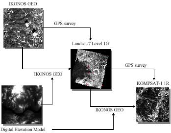
Figure 1. Procedure of automatic precision correction for KOMPSAT-1 EOC image
Below is the detail step for precision correction of KOMPSAT-1 image using IKONOS and Landsat-7 image.
- Step 1: IKONOS image is downsampled to Landsat-7 Resolution
- Setp 2: Generate GCP chips from downsampled IKONOS image
- Setp 3: Matching between GCP chips from IKONOS image and Landsat-7 panchromatic image
- Setp 4: Generate GCP chips from Landsat-7 image using matching result and DEM
- Setp 5: Matching between GCP chips from Landsat-7 image and KOMPSAT-1 image
- Setp 6: Precision correction of KOMPSAT-1 image
In step 2, we will extract the geological information in previously generated IKONOS GEO image and DEM. To compare with human operator, we also used geological coordinate from GPS survey. Figure 1 shows the GCPs on the IKONOS image from GPS Survey.
In step 3, we found the correspondence points on Landsat-7 image with in-house matching algorithms for previously GCP chips. In this stage, we will show the results that our in-house algorithms are effectively removed from the extracted control points so that image image registration and precise image correction can be accurately performed.
Next, In step 4 and step 5, we generated the GCP chips from Landsat-7 image using previously matching results and DEM. We used DEM to extract height information. Finally, we did precisely correct KOMPSAT-1 EOC image using the GCP chips from Landsat-7 image.
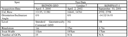
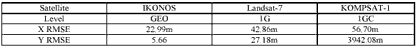
For experiments in this paper, three types of satellite images were used. Table 1 summarizes the characteristics of each image and ground control points that used in GCP chips. The first one was level Geo image of IKONOS panchromatic image. The second one was level 1G image of Landsat-7. The ground sampling distance of Landsat-7 panchromatic image is 15m. The third one was target image from KOMPSAT-1 image to precisely correct. The test site we selected was “Bundang” city of the Republic of Korea.
3. RESULTS AND DISCUSSIONS
In this section, the experimental results from automatic image registration method are presented. The total number of GCPs used in this experiment are 35 points from GPS survey. Below figure 2 is the sample of GCP. First row is the position of GCP in case of IKONOS 1m resolution. Second row is the downsampled IKONOS image to 15m using the nearest-heighbour for same GCP.
Figure 2. Downsampled IKONOS image: white cross on the image is the GCPs from GPS survey
Third row is downsampled using the nearest-neighbourhood resampling method, lowpass filter and histogram matching. At a glance, because third row is almost same brightness pattern as Landsat-7 image, we expect that the result of matching is better than the second row. As can be seen figure 2, in general, GCPs in IKONOS 1m resolution are difficult to find on the low resolution with naked eye. However, practically, the postion of GCPs between 1m resolution and low resolution is the same. Though there are indistinct GCPs in row resolution, our algorithms are able to find correspondence point in Landsat-7 image and remove outlier in success because only use brightness value.
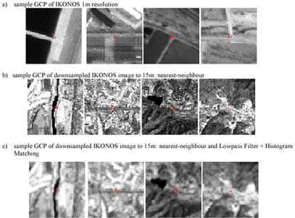
Figure 3. Sample GCPs for raw resolution and downsampled resolution of IKONOS image
As can be seen from the table 2, initial accuracy of each satellite image are shown. IKONOS Geo image is more accurate than other satellite image. It is interesting to note that accuracy of IKONOS Geo is suitable to correct Landsat-7 panchromatic image. However, the accuracy of Landsat-7 is not suitable to correct KOMPSAT-1, so we used coordinate from IKONOS Geo to increase positional accuracy. Also, the RMSE of DEM is 6.30m.
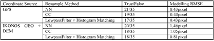
Below table 3 show that the result of automatic precision correction for Landsat-7 image using IKONOS image. We did test for nearest-neighbour, cubic convolution, lowpass filter and histogram matching. We used coordinate from GPS and IKONOS GEO each other. Mostly, the accuracy of GPS is 0.43 pixels. However, the accuracy of IKONOS GEO is from 1.46 pixel for nearest-neighbour to 0.81 for Lowpass filter and Histogram matching. Considering the initial accuracy of IKONOS image, the result of nearest-neighbour is more acceptable than other result. However, if we used lowpass filtering and hitogram matching on IKONOS image, accuracy is more better than other result. Namely, Lowpass Fiter and hitogram matching are good at remove outliers. At most, RMSE of IKONOS GEO cause the error of X direction. Our approach is virtually identical to GPS within 1 pixels.
Below table 4 shows the result of automatic precision correction for KOMPSAT-1 EOC image using the GCP chips of Landsat-7 and DEM. On the surface, using the GCP chips from the geolocational coordinate of IKONOS and DEM with lowpass Filter and histogram matching is more accurate and better matching points than from the geolcational coordinate of GPS with only nearest-neighbour. Because there are different from the number of matching result, it is not reasonable to directly compare the result of GPS with IKONOS GEO. However, as can be seen from table 4, modelling RMSE is within 15m for each case, it is reasonable to use our approach to correct KOMPSAT-1 image.

4. CONCLUSIONS
This paper reports experiments carried out for automatic precision correction using different satellite image. The purpose of this work is two fold. First, we show that it is possible to use high resolution image to correct low resolution image without man power. Second, we show that the number of GCPs can be reduced to get satellite images of precision correction level on certain area by utilizing GCP chips from satellite images of lower resolution but wider swath. In this experiment, we will generate GCP chips from IKONOS panchromatic image and use in-house algorithms to remove the outliers of matching results for Landsat-7 image. And then we will precisely correct Landsat-7 image with matching result and correct KOMPSAT-1 EOC image from previously precise corrected Landsat-7 panchromatic image and DEM.
We achieved the positional accuracy of modelling RMSE within 15m of KOMPSAT-1 image with Landsat-7 and IKONOS image using in-house automatic precision algorithms. Also, we showed that correction for lower resolution using high resolution is possible.
ACKNOWLEDGMENT
The Electronics and Telecommunications Research Institute (ETRI) is acknowledged for supporting this research through a grant “Development of Satellite Image Receiving System”. The authors are also very grateful to Korea Aerospace Research Institute (KARI) for providing the KOMPSAT-1 images and GPS data.
REFERENCES
- Djamdji, J-P., Bijaoui, A., and Maniere, R., 1993, “Geometrical Registration of Images: The Multiresolution Approach”, Photogrammetric Engineering and Remote Sensing, 59(5):645-653
- Zhang, Z., Zhang, J., Liao, M., and Zhang, L., 2000, “Automatic Registration of Multi-Source Imagery Based on Global Image Matching”, Photogrammetric Engineering and Remote Sensing, 66(5):625-629
- McGuire, M and Stone, H.S., 2002, “Techniques for multiresolution image registration in the presence of occlusions”, IEEE Trans. Geoscience and Remote Sensing, 38(3):1476-1479
- Jacp, J-J and Roux, C., 1995, “Registration of 3D images by genetic optimization”, Pattern Recognition Letter, 16:823-841
- Rignot, E.J.M., Kowk, R., Curlander, J.C., Pang, S.S., 1991, “Automated Multisensor Registration: Requirements and Techniques”, Photogrammetric Engineering and Remote Sensing, 57(8):1029-1038
- Fischler, M.A. and Bolles, R.C., 1981, “Random Sample Consensus: A Paradigm for model fitting with applications to image analysis and automated cartography”, Comm. Assoc. Comp. Mach., 24(6):381-395
- Taejung, Kim and Im Yong-Jo., 2003, “Automatic Satellite Image Registration by Combination of Matching and Random Sample Consensus”, IEEE Trans.Geoscience and Remote Sensing, 41(5):1111-1117