| GISdevelopment.net ---> AARS ---> ACRS 2004 ---> Data Processing: Automatic Classification |
Expert classification for
Land Cover Mapping of Bang Pakong Watershed, Thailand
Siam
Lawawirojwong
Geo-Informatics and Space Technology Development Agency, Bangkok, Thailand
Tel: +66-2-5790116 Fax: +66-2-5790116
E-mail: siam@gistda.or.th
Sura Pattanakiat (Ph.D), Charlie Navanugraha (Ph.D)
Associate Professor, Faculty of Environment and Resource Studies
Mahidol University, Salaya, Nakhonpathom, Thailand
Tel: +66-2- 4415000 Fax: +66-2- 4419510
E-mail: enspt@mahidol.ac.th, encnv@mahidol.ac.th
Prasong Sanguantham
Assistant Professor, Faculty of Forestry (M.S.)
Kasetsart University, Chatuchak, Bangkok, Thailand
Tel: +66-2- 9428108 Fax: +66-2- 9428108
E-mail: fformgt@ku.ac.th
ABSTRACT
The main objective of this research is to generate a knowledge-based and to develop the expert classification using Landsat-7 (ETM+) imagery for land cover classification of Bang Pakong watershed. Image preparations included radiometric and atmospheric corrections, geometric correction, image enhancement, image mosaic, and image subset.
The expert classification applied the unsupervised classification (ISODATA clustering method) and knowledge-based operation which including spectral characters, GIS data (DEM and soil moisture regime) and spatial models (clump model, NDVI model, mean NDVI per zone model, WI model, mean WI per zone model, slope model, and aspect model) to classify the conditions for land cover category identification. The land cover categories are identified as residential and open space area, abandoned land, mixed deciduous forest, mangrove forest and wetland, paddy field, other vegetation, and water bodies. The percentages of accuracy for each land cover categories using maximum likelihood classification are 62.5, 64.29, 81.82, 75, 64.71, 66.67, and 54.55, respectively. Meanwhile, the percentages of accuracy for the expert classification are 75, 78.57, 90.91, 87.5, 70.59, 76.19, and 72.73, respectively. Therefore, the accuracy for each land cover category from the expert classification is higher than the maximum likelihood classification. Furthermore, the overall accuracy of the expert classification is about 78%, and the maximum likelihood classification is only about 67%. Thus the accuracy of the expert classification is about 11% higher than the maximum likelihood classification.
INTRODUCTION
In the past, while dealing with image classification for land cover mapping, quite often only gray level, texture, geometric characteristics, and the knowledge from optical spectrum bands are used to classify land cover from satellite image. The benefit from such basis was limited in ability of land cover classification, which could not identify precisely on land cover. The classification of land cover requires sophisticated skill and techniques. Traditionally, there were inefficiencies for not only upgrading the classification accuracy by simple spectral classification technology but also increasing its categories. For this reason, this study provides the land cover classification knowledge-based system by system language model which is done through AI (Artificial Intelligence) combined with the information from RS (Remote Sensing) and GIS (Geographic Information System). It is called expert classification.
With the assistance of the expert classification, it is feasible to integrate spectral information from remote sensing and transformed data from GIS to set as the reference material for land cover classification. Through integrated database and parameters, the related uncertainty levels data can be classified. The classification procedure must relatively fit in with true land cover condition, and also have a great effect on land cover classification. Furthermore, it also avoids the inconvenience of classification procedures towards further classification. In addition, to apply and develop the knowledge-based into a better condition of land cover classification, the focus is aimed at building up the knowledge-based system with spectral information in remote sensing and the indirect data in GIS, and inference from knowledge in special domain range to make classification decision. On the other hand, it is possible to hope to promote the accuracy of image classification which can serve as a powerful tool to apply on environmental monitoring or changing detection in the future.
STUDY AREA
The study area covers the Bang Pakong watershed which in the eastern part of Thailand. It covers an area of Saraburi, Phatumthani, Chacherngsao, Nakhon Nayok, Prachinburi, and Chonburi province. (Figure 1)
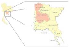
Figure1. Bang Pakong Watershed Area
METHODOLOGY
This study applied the unsupervised classification (ISODATA clustering method) and knowledge-based operation which including spectral characters and GIS data (DEM and soil moisture regime) and spatial models to classify the conditions for land cover categories identification. The land cover categories are identified as residential and open space area, abandoned land, mixed deciduous forest, mangrove forest and wetland, paddy field, other vegetation, and water bodies. The detail steps and contents are described as follows:
Data Sources
Landsat satellite images are the main data sources which are the main basis of spectral knowledge, while overlaid with other GIS data and DTM sources to assist for expert classification.
Model Application
The application models were created and based on model spatial modeler for variables of knowledge-based generation. It is a highly flexible tool when applying Model Maker together with Spatial Modeler Language. The Spatial Modeler Language was a modeling language that was linked internally by Model Maker to execute the operations specified in the graphical models. The spatial models include clump model, NDVI model, mean NDVI per zone model, WI model, mean WI per zone model, digital elevation model (DEM), slope model, and aspect model. Ultimately, all variables, which included Landsat-7 (ETM+) imageries (band 1-5 and 7), ISODATA clustering, clump model, NDVI model, mean NDVI per zone model, WI model, mean WI per zone model, DEM image, slope model, aspect model and soil moisture image, were used to generate the knowledge-based system for classifying the land cover categories in
Bang Pakong watershed
Classification Experiment and Knowledge Representation
Knowledge-based system inference is a way to show the relationship among data with union or mixed forms from decision tree. Take paddy field catalog for example, This land category was found when it was a flat plain, that had no slope (slope closed to 0%), had no aspect (aspect = 361), DEM less than 100 meters, clump more than 40, soil properties moisture regime is aquic moisture regime and it was vegetation, that mean NDVI per zone was more than 0.4 and no water (mean water per zone less than 1) then land cover type was recognized as paddy or rice field.
Flow diagram of Knowledge-based system
Integrating data resource with the logic of knowledge-based system, this research uses a complete flow framework (Figure 2.) to show the relationships from all aspects (including spectral knowledge, GIS data, spatial model and etc.) and finally, the result of expert classification was illustrated land cover map of entire Bang Pakong watershed.
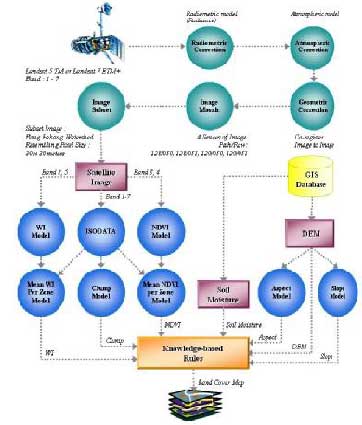
Figure 2 Expert Classification Flow Diagrams
RESULT AND DISCUSSION
The study applied the unsupervised classification (ISODATA clustering method) and knowledge-based operation which including spectral characters and GIS data (DEM and soil moisture regime) and spatial models (clump model, NDVI model, mean NDVI per zone model, WI model, mean WI per zone model, slope model, and aspect model) to classify the conditions for land cover categories identification. The land cover categories are identified as residential and open space area, abandoned land, mixed deciduous forest, mangrove forest and wetland, paddy field, other vegetation, and water bodies. The knowledge-based system was implemented to run the Knowledge Classifier on ERDAS IMAGINE software. Within knowledge-based, it consisted of logic or rule that determined land cover type. Finally, the result for expert classification is land cover map of Bang Pakong watershed, as shown in Figure 3. The land covers categories results are as following:
- Residential and open space area (481.99 km 2 or 5.48%) consists of urban, built-up lands, bared soil, streets and highway.
- Abandoned land (925.67 km 2 or 10.52%) consists of grasses, herbs and scrub, and agriculture harvested land.
- Mixed deciduous forest (1,727.33 km 2 or 19.64%)
- Mangrove forest and wetland (54.20 km 2 or 0.62%)
- Paddy fields (244.61 km 2 or 2.78%)
- Other vegetation (4,265.66 km 2 or 48.50%) that consist of orchards, field crops, plantations, and etc.
- Water bodies (1,095.88 km 2 or 12.46%).consists of streams, canals, reservoirs, shrimp farms, freshwater aquacultures, and salt pans.
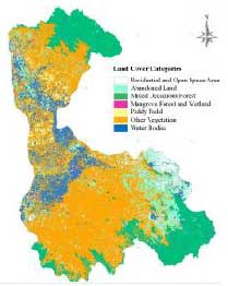
Figure 3 Classification result by expert classification
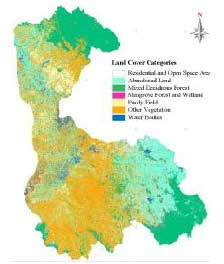
Figure 4 Classification result by maximum likelihood classification
Furthermore, it was found that the accuracy for each land cover category from the expert classification also provided higher accuracy than the maximum likelihood classification, as shown in Figure 5. This better output was influenced by enhancement technique that was supported by GIS data coincident with basic spectral knowledge.
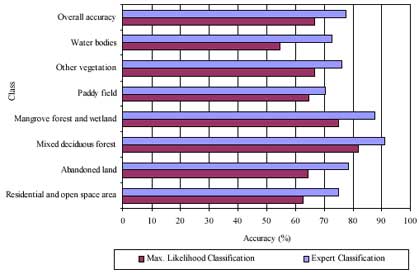
Figure 5 The histogram of comparison between expert classification and maximum likelihood classification output
CONCLUSION
This research superimposes unsupervised classification into knowledge-based system while spectral characteristics and GIS data can increase classification accuracy. Therefore, the expert classification can duplicate human knowledge and provides a rules-based approach to multi- spectral image classification, post classification refinement, and GIS modeling. Since, the spectral knowledge, external programs, simple scalars, and GIS data, which including slope, aspect, altitude, and soil moisture, spatial models, had been used to generate the knowledge- based for categorizing the land cover. Thus it shows that the expert classification can increase the classification accuracy. However, the expert classification for this study is still faced with various problems and limitations which are included as follows:
- Image resolution of Landsat 7 ETM+ (Band 1-7) is not suitable for higher level of the land cover classification. Thus, high-resolution imagery should be introduced to support this matter. In addition, if more details of GIS data (e.g., contour, soil series, and etc.) are input, it is possible to get the best output for the expert classification.
- The satellite imagery for this case is only the imagery from Landsat 5 TM or Landsat 7 ETM+ and the knowledge-based system that was created in this study can be used only to classify the land cover of Bang Pakong watershed. However, its concept can be modified and applied to other sites.
REFERENCES
- Fu-jen Chien, Tien-Yin Chou. The Study of Knowledge-Based Database Assist for Urban Land Use Classification. GIS Research Center, Department of Land Management, Feng Chia University, 2000.
- Info@erdas.com. (No date). Knowledge Base and associated models for use with IMAGINE Expert Classifier [Online]. Available from:http://support.erdas.com/downloads/models/ model_descriptions/descriptions.html#KB. [2002 June 10].
- Sukit Viseshsin, Chanist Prasertburanakul. High Resolution Imagery Classification. National Mapping and Geo-Informatics Conference, 2000. P 427-431.