| GISdevelopment.net ---> AARS ---> ACRS 2002 ---> Photogrammetry |
Contribution of Digital
Photogrammetry for Cadastral Surveys
K S K Wijayawardana
Assistant Superintendent of Surveys
Photogrammetric Unit, Survey Department
P.O.Box. 506,Narahenpita, Sri Lanka
Tel: +94-1588871,
E mail: sgsurv@sltnet.lk, dsgmap@sltnet.lk
K S K Wijayawardana
Assistant Superintendent of Surveys
Photogrammetric Unit, Survey Department
P.O.Box. 506,Narahenpita, Sri Lanka
Tel: +94-1588871,
E mail: sgsurv@sltnet.lk, dsgmap@sltnet.lk
Abstract
Sri Lanka is an island where total land resources are limited and also shrinking rapidly with increasing population. The demand for land for agriculture, housing and industry are relatively increasing. These factors have lead to misuse and degradation of land in many areas. Major problem is that irregular settlement in both urban and rural areas. This is based on weakness of current deed registration system. The current system is based on a series of individual records of land transaction. To address and remedy these problems the Land Titling and Related Services Project was launched recently. In this connection, the Survey Department has a major roll to take part such as, initial investigation to carry out to identify the land parcel boundaries. This investigation is based on existing maps and orthophotographs.
This paper describes identification of land parcel boundaries using digital photogrammetric method. Now department is enriched with 2000dpi scanner and sophisticated software like VirtuoZo for softcopy photogrammetry. It provides facility to produce high quality, orthorectified, and geo-referenced aerial photographs quickly, easily and cheaply. Then parcel boundary information can be extracted by on screen digitising in Microstation environment. The major problem is to collect information, which covered, by obstacles such as trees, buildings etc. To overcome this, survey team with Palm Top computer, GPS and related orthoimage, should go to the field parallel to the adjudication team. It provides capability of solving boundary disputes by adjudication team as well as picking up obstacle boundaries by survey team. Finally the system consist with accurate legal boundaries with orthoimage. The local banks and other institutions could consider this information to arrive at an accurate title assessment. In addition to that one supreme advantage is that clients could have valuable title certificate with part of orthoimage and vector map for the relevant land plot.
Introduction
Land is the most important thing to a man and its wide use is crucial for the economic, social and environment advancement of all countries. Though it is part of man’s natural heritage, access to land is controlled by ownership patterns. The decision-makers that make decisions about the land (ownership) need more information, such as legally confirmed individual land parcel boundaries. The current system of land tenure is based on a series of individual records of transactions without considering the accurate land marking boundaries. This irregular land management system caused to cultivation of steep slopes, deforestation, encroachment of state lands and irregular settlement of both urban and rural areas. In this connection the Government has decided to launch proper land management system namely parcel based registration of title. The Survey Department has a major roll to take part in this system, such as, initial investigation to carry out to identify the land parcel boundaries. This investigation is based on existing maps and orthophotographs. This paper describes identification of land parcel boundaries using digital photogrammetric method.
Methodology
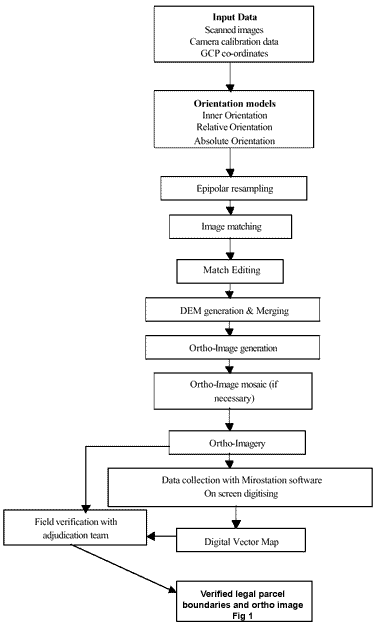
As a learning and innovation, particular land parcel was selected in greater Colombo area, which covered recently taken 1:8000 scale aerial photographs and were scanned 25- microns resolution with sophisticated VX4000 scanner. The output is raster image with 20cm pixel (picture element). The next phase is to input raster images and paramete rs such as camera calibration data and ground control points’ co-ordinates to VirtuoZo NT Workstation for further processing. The VirtuoZo software treats two overlapped images as a single stereo image, this process involves the following three performances namely, inner, relative and absolute orientations. Inner orientation is based on the camera calibration values and measured co-ordinates of the fiducial marks. Y – parallaxes from the original imagery removed in relative orientation phase. Consequently absolute orientation was performed to transform the stereo model from photogrammetric co-ordinate system to ground co-ordinate system. As shown in Fig 1 step Epipolar resampling to Ortho-Imagery were performed by the computer with least interfering of operator. There is an interface between VituoZo and Microstation software. In this connection on screen digitising of parcel boundaries performed Microstation environment. In the field verification/adjudication stage palm top computer with digitised parcel boundaries, relevant ortho image and other peripherals (GPS etc.) taken to the field. This includes confirmation of boundaries and its completeness.
Workflow is as follows,
Result and Discussion
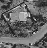
Fig 2: Ortho image of relevant land parcel
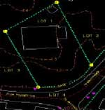
Fig 3: Parcel boundaries after on screen digitising
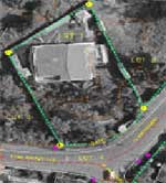
Fig 4: Ortho image with confirmed & completed parcel boundaries
Even if we spent large amount of money for instrumentation, as a long term basis it would be benefited a lot as it will take only a few hours to collect boundary information (if there is no boundary disputes). In addition to collect boundary information, the client could be provided valuable title certificate (as shown in Fig 5), which include description of land and personal details. Benefits goes to individuals as optimal utilisation of lands and access to capital through simplified and secured credit arrangements etc. In this way, public confidence and understanding will be enhanced regard the system. Developing countries such as Sri Lanka, this system is very suitable because no need to spend much money for hardware/software maintain as well as no need of skill full persons to operate. As there are 8.5 million land parcels in Sri Lanka, time taken to identification of land parcel boundaries will be reduced adopting this system dramatically. Eventually, emphasis of developing such a system to benefit country both economically and socially.
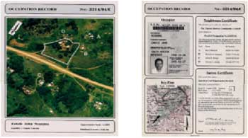
Fig 5