| GISdevelopment.net ---> AARS ---> ACRS 2002 ---> Land Use/Land Cover |
Study on the changing
characteristics of land use as commons in Roviana, western province,
Solomon Islands using high resolution satellite data and aerial
photographs
Takuro Furusawa,Krishna
Pahari,Ryutaro Ohtsuka
Department of Human Ecology, School of International Health
University of Tokyo 7-3-1, Hongo, Bunkyo-ku, Tokyo 113-0033, Japan
Tel: (81) -3- 5841-3486
Fax: (81)-3-5841- 3395
Email: mailto:takk%20@humeco.m.u-tokyo.ac.jp
Masahiro Umezaki
Section of International Health
Graduate School of Tokyo Medical and Dental University
1-5-45 Yushima, Bunkyo-ku, Tokyo 113 -8519, Japan
Tel: (81) -3- 5803-5188
Fax: (81)-3-3818- 7176
Abstract
Tropical rain forests in Asia- Pacific area are disappearing due to logging operation by multinational companies and also due to traditional and modern uses by local people. Remote sensing has been widely applied to monitor the changes in land cover over time, though few studies in rural areas have used the high resolution satellite data such as IKONOS. This study aims to observe the spatio-temporal change in land cover and land use patterns in a village of Solomon Islands, where commercial logging was operated in 1993. The village territory consists of two parts: a larger island, in which logging and other deforestation have been under progress, and a smaller reef island, in which only exclusive horticulture has been done. The IKONOS data acquired in 2002, colored aerial photographs in 1991, black-and- white aerial photographs in 1969 and 1947 were analyzed to estimate land cover and land use of the areas and they were compared to elucidate the changing process.
Introduction
Tropical rain forests in Asia-Pacific region are rapidly changing owing to logging operation by multinational companies as well as utilization of lands for traditional subsistence and/or cash-earning activities by local people under the influences of a variety of factors such as economic development and population i ncrease.
Shifting cultivation, which has been traditionally practiced in limited area with rotati on, is sustainable, if the period of cultivation is short enough and the period of fallow is long enough for the soil to recover its fertility (Whitmore, 1998).
In Western Province of Solomon Islands, the use of land under the communal control and utilization has been changing since 1980s when economic development commenced.
Remote sensing using high resolution satellites such as IKONOS has potentials to assess the environmental changes. Few studies, however, have been conducted in local areas of Asia- Pacific tropics, and none in Solomon Islands. This study aimed to investigate changes in land use in a portion of New Georgia Island (called Dekurana) in Western Province of Solomon Islands by comparing IKONOS image in 2002 and aerial photographs in 1991. In the target area, the commercial logging was operated and the inhabitants have been engaged in their cash-earning activities as well as horticulture. Also, spatio- temporal change in land use was investigated in a nearby reef island (called Dora), in which horticulture had been conducted exclusively since a few centuries before; aerial photographs in 1969 and 1947 and IKONOS image in 2002 were used.
Study Areas and Field Survey
The field survey was conducted in January to October in 2001 and May to July in 2002 in Dekurana and Dora Island; the boundary of Dekurana area was defined by the high court of Solomon Islands (High Court of Solomon Islands, 19 94). Both areas were used by Olive village of Saikile tribe in Roviana Lagoon (Figure 1). There were 347 inhabitants in 49 households in February 2001, and most of them were engaged in horticulture of tuberous crops and fishing. The two areas had been u tilized by not only Olive villagers but also other people of Saikile tribe, whose number was similar to Olive, although gardens (future tree plantation) along the main logging roads and the areas just surrounding Olive settlement in Dekurana were used intensively by the Olive villagers.
In the Olive village’s territory (Dekurana area), the reforestation or plantation of introduced tree species such as Eucalyptus deglupta and Tectona grandis have been conducted since 1997 for the purpose of future cash income of the community. It had been particularly intensified since 2001 when the community gave permission for each household to clear and use one ha of land along the logging road. These lands were used as gardens for 2 years after clearance and tree planting; the garden making was beneficial for protection of soils from the strong sunshine and rainfall and for minimization of labor for horticulture and maintenance of planted trees.
The remote-sensing analyses focused on two areas (Figure 1) where the villagers practice almost all their subsistence activities, such as horticulture, gathering foods and materials, and private saw-milling. These two areas differed characteristically. Dekurana had started to be cleared for horticulture or construction of coconut plantations since the end of 1960s and used for the cultivation of cash crops (e.g., cacao) and tree plantation recently.
Dora Island had been used exclusively for gardens since a few centuries ago, though limited areas had been used for tree plantati ons and cash crop groves. The natural soil composition was far richer in Dora Island than in New Georgia Island (Hansell et al., 1975). According to the authors ’ observation i n 2001, 67.1% of gardens of 14 households in Olive were made in Dekurana and 31.8% in Dora Island.
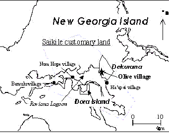
Figure 1. The location of Olive and two areas analyzed remote sensing.
Materials and Methods
In the field, ground control points and other ground truth data were acquired, using GPS systems of Trimble Ltd.; TSC1 was used for collecting rover data and 4600LS for base data. In addition, socio-economical, behavioral, demographic and other data were collected. Data used were (1) IKONOS panchromatic and multispectral images acquired in July 2002, (2) digital colored aerial photographs acquired in October 1991 (scale 1:20,000), and (3) a black-and-white aerial photograph in May 1969 and in October 1947 (scale 1:50,000). Data (1) and (2) were used for analysis of change in land use in Dekurana between 1991 and 2002. Data (1) and (3) were used for the land use in Dora Island in 1947, 1969 and 2002.
The IKONOS panchromatic image was corrected based on ground control points after the differential correction. Multispectral IKONOS image and aerial photographs were registered with this georeferenced panchromatic image.
Analyses for Dekurana Data
IKONOS Image Analysis
Ten classes for land cover were made initially: (1) natural matured forest, (2) degraded/secondary forest, (3) coconut grove, (4) garden, (5) tree plantation, (6) grassland, (7) bare soil, (8) house, (9) water, and (10) cloud. A supervised maximum likelihood classification was performed for the whole image of IKONOS multispectral data . In this stage, gardens and tree plantations could not be distinguished properly from grasslands or bare soils. These two classes were, therefore, classified manually, making AOI (area of interest) files on panchromatic image. Garden area contained small coconut groves and other cash crop groves standing in the cleared lands for horticulture of tuberous crop. The areas with planted trees which were big enough to be detected on the image (one year or more after planting) were interpreted as tree plantation. These AOI files for gardens and tree plantations were then combined to the computed image to produce the classification map in 2002 .
Aerial Photo Interpretation
Mosaic image in 1991 was created by combining five photographs. This was interpreted manually by creating AOI files for each land class, taking same category in the IKONOS image analysis. Cloud cover, which was little , was located in the area of natural forest. Therefore , this portion was classified as natural matured forest. For the purpose of comparing the results of aerial photograp hs with IKONOS image, cloud cover in IKONOS image was also applied to the corresponding area on the classified image of aerial photographs .
Analyses for Dora Island Data
Gardens in Dora Island were interpreted manually on IKONOS panchromatic image and aerial photographs in 1947 and 1969; photographs in 1991 did not cover this area.
Results and Discussion
New Georgia Island in 2002
Figure 2 shows the land cover of Dekurana area in 2002 based on the IKONOS image. The logging roads, which were classified as bare soil, ran from south -east to north-west, and down to settlements. Abandoned roads, which were classified as grassland, expanded into the inland forest. Gardens and tree plantations were located along coast, river and logging road. Degraded forests by selective logging could not be classified from natural forest because nine years had passed since the operation.
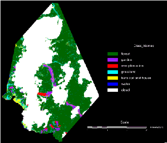
Figure 2. Land cover of Dekurana area in New Georgia Island in 2002 based on IKONOS multispectral image.
Change of Land Cover of Dekurana Area between 1991 and 2002
Figure 3 shows the land cover of Dekurana area in 1991, based on the aerial photographs; cloud cover corresponded to thick-cloud cover on IKONOS image in 2002. Deforestation occurred only along the coast. Gardens located along river, coast (just behind mangroves), and surrounding areas of settlements. Degraded/secondary forest, which also surrounded the settlements, included the area for mixture of cultivated useful trees and natural vegetation, and the forest cut by means of the villager’s portable saw-milling. In comparison with the land cover in Figure 2, this land cover was characterized by expansion of tree plantations in large areas along coast and river, instead of the gardens. Table 1 shows the change in areas from 1991 to 2002. Forest, which included natural and degraded forest and coconut and useful plant groves, decreased from 1017.1 ha to 870.7 ha. The increase of grassland and bare soil reflected the increase of anthropogenic disturbance on forest. The comparability between the supervised classification computed from four-band high resolution image and the manual classification of aerial photograph should be improved in further works.
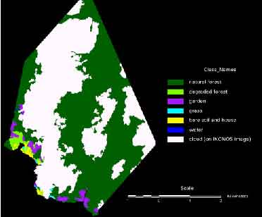
Figure 3. Land cover of Dekurana area in New Georgia Island in 1991 based on aerial photographs.
Gardens in Dora Island
Areas of lands cleared for horticulture in Dora Island increased slightly from 23.3 ha in 1947, though 28.2 ha in 1969, and to 31.0 ha, including 2.1 ha of tree plantation, in 2002. This increase of garden area was small relative to that in Dekurana area during the 11 years. During 22 years from 1947 to 1969, 11.2 ha were newly cleared and 17.6 ha were done during 33 years from 1969 to 2002, as shown in Table 2. On the other hands, 13 ha (56.0%) of the total area cleared in 1947 had recovered to be forest in 1969, and 16.8 ha (59.6%) of the total area cleared in 1969 to be forest in 2002. In all area cleared in 2002, 13.4 ha (43.2%) had been cleared in either of previous two periods. These results indicated that the mixture of the lands recovered to forest in long term, implying continuous land use under long fallow in this area.
Figure 4 shows the location of each type of land described in Table 2. The central and upper-left parts were used in two or more periods, indicating the short-term rotating cultivation for the limited area. The shifts of garden locations from west to east were also observed. This would be explained by two reasons. The first was the change in main crops especially between 1947 and 1969; according to several informants, sweet potato, the main crop in 2002, started to be cultivated intensively in 1950s while cassava, taro and yams had been predominant. People probably changed the locations of gardens according to the favorable ecological conditions for each tuberous crop. Another explanation was the population increase, though the increase of area was quite slight. All people were likely to make gardens in this area, because they recognized that this rich -soil area would be necessary in the case of land scarcity in other areas. Although the foods necessary for the increased population were supplemented by the new gardens in Dekurana area, the people continuously made gardens in Dora Island even if small area. In relation to this pattern, the villagers recognized two nut tree species as properties in their custom, descending from their ancestors to only the offspring, and people tended to hesitate to cut the surrounding forests of these nut trees and to make gardens, though the area covered by these nut trees was limited.
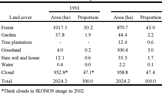
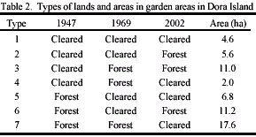
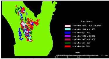
Figure 4. The locations of gardens in Dora Island in 1947, 1969 and 2002
Conclusions
Deforestation of Dekurana area of New Georgia Island was observed, changing from gardens along coast and river to tree plantation up to 2002. In contrast, gardens and their surrounding forest in Dora Island were mixture of newly cleared garden, area continuously used for gardens and regenerated forest in 2002.
References
- Hansell, JRF., Wall, JRD., Webb, IS., and Wash, PG., 1975. Soil descriptions and analyses from New Georgia and the Russell Islands, Solomon Islands. Supplementary report 19, section A, Land Resources Division, Ministry of Overseas Development, London.
- High Court of Solomon Islands, 1994. Civil Case 236 of 1994. High Court of Solomon Islands, Honiara.
- Whitmore, TC., 1998. An Introduction to Tropical Rain Forests, Second Edition. Oxford University Press, New York, pp. 156-173.