| GISdevelopment.net ---> AARS ---> ACRS 2002 ---> Land Use/Land Cover |
Linear mixture modeling for
quantifying vegetation cover using time series NDVI data
Lin Zhu
Center for Environment Remote Sensing (CEReS)
Chiba University
1-33 Yayoi-cho, Inage-ku, Chiba, 263-8522
Tel: (81) -43-290-3850
Fax: (81)-43-290-3857
E-mail: zhulin@ceres.cr.chiba-u.ac.jp
Japan
Ryutaro Tateishi
Center for Environment Remote Sensing (CEReS)
Chiba University
1-33 Yayoi-cho, Inage-ku, Chiba, 263-8522
Tel: (81) -43-290-3850
Fax: (81)-43-290-3857
E-mail: zhulin@ceres.cr.chiba-u.ac.jp
Japan
Center for Environment Remote Sensing (CEReS)
Chiba University
1-33 Yayoi-cho, Inage-ku, Chiba, 263-8522
Tel: (81) -43-290-3850
Fax: (81)-43-290-3857
E-mail: zhulin@ceres.cr.chiba-u.ac.jp
Japan
Ryutaro Tateishi
Center for Environment Remote Sensing (CEReS)
Chiba University
1-33 Yayoi-cho, Inage-ku, Chiba, 263-8522
Tel: (81) -43-290-3850
Fax: (81)-43-290-3857
E-mail: zhulin@ceres.cr.chiba-u.ac.jp
Japan
Abstract
Linear mixture modeling technique has been applied to time series NOAA AVHRR and SPOT VEGETATION monthly composite NDVI data in order to determine its effectiveness as a mapping tool. Fraction images of forest, farmland and steppe were extracted using Constrained Least Squares (CLS) method over a test area. Classification results of multi-temporal Landsat TM data were used to validate the performance of linear mixture modeling. Also, land cover change of the test area between 1992 and 2000 was detected. Then, linear mixture modeling technique was extended to vegetation cover mapping of Asia. Selection of appropriate endmembers was based on Global Land Cover Ground Truth (GLCGT) database. Percentage images of vegetation cover of Asia were obtained from SPOT VEGETATION monthly composite NDVI data of 2000. This study suggests that with improved estimates of endmember values and more sophisticated methods to fully utilize the included information, linear mixture modeling technique can have great potential when applied to coarse spatial time series NDVI data for global studies.
Introduction
Study on geosphere- biophere -atmosphere interaction depends on reliable and unambiguous definition of the existing terrestrial vegetation. Vegetation characteristics, including land cover and phenology, affect processes such as water cycle, absorption and re-emission of solar radiation, momentum transfer, carbon cycle, and latent and sensible heat fluxes (Maselli et al., 1998). Variations in the composition and distribution of vegetation represent one of the main sources of systematic change on local, regional, or global scale, and the ability to detect these variations using remotely sensed data is of utmost importance for both environmental researches and management activities (Hall et al., 1995). Traditionally, vegetation monitoring by remotely sensed data has been carried out using vegetation indices, which are mainly derived from mathemati cal transformations of reflectance data in red (R) and near-infrared (NIR) channels. One of the most widely used indices is the well-known normalized difference vegetation index (NDVI).
Vegetation monitoring demands high temporal frequency information to follow the rapid vegetation phenological change. This can be realized by using satellite data such as NOAA AVHRR data and SPOT VEGETATION data for their daily coverage and synoptic overview. NOAA AVHRR and SPOT VEGETATION data have been widely utilized for global, continental and regional land use and land cover studies. However, one major problem when using these data is their volume and noise. Fortunately, these can be solved through monthly maximum composite processing. The use of monthly composite data represents a compromise between temporal frequency and the need for cloud-free data (Moody and Strahler, 1994). It also provides a means to reduce data volume while maintaining vegetation phenological information. Actually, most vegetation mapping applications at broad spatial scales have been based on time series NDVI data (Tucker et al. 1985, Loveland et al. 1991), it is also indicated that global and regional land cover classification derived from remotely sensed data has to date generally relied on a single year.time series to characterize phenology of the vegetation (Defries et al., 2000). Another major problem when using these data is their poor spatial resolution. Usually, the large ground area of each AVHRR or VEGETATION pixel is a mixture of several land cover types. Conventional classification approaches that categorize each pixel into a discrete vegetation type do not fully utilize the rich information content of the data to describe gradients and mosaics in the landscape, and also variation in vegetation characteristics within a cover type is obscured (Defries et al., 2000). Efforts to address the problem of mixed pixels are of increasing importance as emphasis is being placed in providing global-scale monitoring.
A number of researches have been taken to depict pixel heterogeneity in land cover from remotely sensed data. Linear mixture modeling to deconvolve proportional cover based on spectral reflectance of endmembers or pure pixels is a main one. In general, linear mixture modeling techniques have been mainly applied at local or regional scales over limited areas using single date or multi- temporal spectral reflectance data. Clearly, there is a need for operational methods permitting the application of linear mixture modeling directly at NDVI l evel (i.e., the mixed NDVI is the sum of components’ NDVIs weighted by the components’ surface proportions), especially for global and regional studies. Only a few researches have addressed this issue in view of improving crop monitoring and yield predicti on through estimation of pure crop NDVI profiles (Kerdiles and Grondona, 1995), and almost no research has addressed application of linear mixture modeling for NOAA AVHRR or SPOT VEGETATION monthly composite NDVI data, neither at local scales, nor regional and global scales. Therefore, a research in this area should be a meaningful challenge.
In this study, firstly, linear mixture modeling technique was applied to time series AVHRR monthly composite NDVI data ranging from April 1992 to March 1993. The percentages of forest, farmland and steppe in each pixel were determined by the CLS method (Shimabukuro and Smith, 1991) over a typical agricultural area in the northeast region of China. Also, multi- temporal Landsat TM data and NOAA AVHRR monthly composite NDVI data were classified using conventional methods. A good agreement was found between fraction images and classification results of Landsat TM data. Then, in the same way, fraction images were obtained from time series SPOT VEGETATION monthly composite NDVI data ranging from January to December of 2000, and land cover change between 1992 and 2000 was detected. Finally, linear mixture modeling technique was extended to vegetation cover mapping of Asia.
Linear Mixture Modeling
Linear mixture modeling assumes that each image pixel contains information about the proportion and the spectral response of each component within the ground resolution unit, and the response of each pixel is taken as linear combination of the responses of all components in the mixed target. Actually, this assumption should be true only for original channels. However, recent studies have demonstrated that a linear combination of NDVI values implies only very minor inaccuracies (Kerdiles and Grondona, 1995). In this study, the linear mixture model can be formulated as
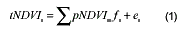
Where i tNDVI is the time series monthly composite NDVI value for a pixel in period band i , ij pNDVI is the pure monthly composite NDVI value of component j in period band i , j f is the proportion of component j in the pixel, and i e is the error term for period band i Subject to the constraints
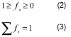
Since the sum of the proportions for any resolution element must be one and the proportion values must be nonnegative. The Constrained Least Squares method is applied to estimate the proportion of each component in a pixel by minimizing the sum of squares of the errors.
Local Area Study
Test Area
The test area , 90 x 60 km, with geographical coordinates from 42 0 15þN to 42 0 45þN and 122 0 0þE to 122 0 45þ E, is located in a typical agricultural area of Liaoning province in the northeast region of China. The main cover types are forests, pastures and crops. The most common crops are corn and paddy, as well as soybean, wheat, etc. Dominant forests consist of pine and poplar. The main crop season is from April to October. The information collected by ground truth survey is useful for t he classification of multi-temporal Landsat TM, NOAA AVHRR and SPOT VEGETATION monthly composite NDVI data and the application of linear mixture modeling.
Image Data and Preprocessing
Two Landsat TM images are used as the basis for endmember collection in linear mixture modeling, and in validation of the fraction images. The multitemporal Landsat TM images collected on 19 May 1994 and 8 September 1994 are selected mainly because they are the cloud- free s cenes in the crop season. A scene of 2700 x 1800 pixels is cut from each Landsat TM image and georeferenced using nearest neighbor resampling algorithm, with resampling size of 25m pixel yielding RMS error of less than 1 pixel. All channels of TM data are used except the thermal channel 6.
The NOAA AVHRR 1km 10-day composite NDVI data spanning April 1992 through March 1993 is based on the Interrupted Goode Homolosine map projection. In order to march different purposes, it is transformed to latitude/longitude projection (Plate Carree Projection) with 30-seconds resolution. The SPOT VEGETATION 1km 10 -day composite NDVI data spanning from January to December 2000 is already in latitude/longitude projection with 1/112-degree pixel size. It is also transformed to 30-seconds resolution. Then, these dataset are recomposed to monthly composite NDVI dataset based on maximum value compositing method, in which the NDVI is examined pixel by pixel during the compositing process to determine the maximum value. The retention of the highest NDVI value reduces the number of cloud- contaminated pixels and selects the pixels nearest to nadir (Holben, 1986). The monthly composite NDVI data of the test area , image of size 90 lines by 60 samples, are cut from these two datasets. In this study, all 12 months time series monthly composite NDVI data are used in order to include full phenological information of the whole year.
Approach
Multi-temporal Landsat TM data is classified by maximum likelihood method to generate a reference land cover map. Eight land cover classes are deemed sufficient to cover almost all the variability of the test area (Forest, Corn, Paddy, Grassland, bare land, Urban, Water and Seasonal water). The overall classification accuracy is estimated to exceed 85 percent (Zhu and Tateishi, 2000). Also, three land cover types, namely forest, grassland and farmland, account for 97.1 percent of the total test area. Time series NOAA AVHRR monthly composite NDVI data is also classified using minimum distance method in order to provide a comparison with the fraction images obtained from linear mixture modeling. For application of linear mixture modeling, the classified image of Landsat TM data is filtered using a 5 x 5 majority filter in order to reclassify isolated pixels belonging to one land cover type to the same land cover type as the majority of their neighbors in the image. Then, the filtered image is degraded to the spatial resolution of 1km data to make it easy for endmember collection. Assuming three components within a pixel, the CLS method is applied to the NOAA AVHRR and SPOT VEGETATION monthly composite NDVI data, respectively. The extracted fraction images are scaled to integer values from 0 to 200.
Analysis
Comparing the classified images obtained from multi -temporal Landsat TM, time series NOAA AVHRR and SPOT VEGETATION monthly composite NDVI data using conventional classification methods with the faction images extracted using linear mixture modeling, in general, there is a fair agreement between both for the results obtained using minimum distance method and linear mixture modeling. However, we can find visually that the fraction images are more detailed, and can reflect the land cover reality better than the result obtained from the conventional classification method. The advantage of the fraction images is that.they contain physical information, i.e., amount of each component within a pixel.
Based on a simple check on the land cover estimation of the total test area and three selected small areas, we can find that the area percentage estimation obtained by the conventional method seems not so good. Although the results obtained from the conventional method are acceptable, the limitation of these methods is obvious and inevitable. The linear mixture model performs better. Moreover, we can detect land cover change of the test area more accurately from the fraction images. But as with training areas selection in other supervised classification methods, endmember collection in linear mixture modeling has a significant effect on the final fraction images.
Vegetation Fraction of Asia
Endmember Selection
The key to a successful linear mixture modeling is the selection of appropriate endmembers. Endmembers should define a coherent set of characteristics that are representative of physical components on the surface, and should also describe the full range of natural variability inherent in the ground. Fortunately, the development of Global Land Cover Ground Truth (GLCGT) database facilitates endmember selection. The GLCGT database is developed under the cooperation of many projects and researchers, and will be free for usage by any researcher. The objective to develop GLCGT database is to realize reliable and continuously improved land cover ground truth data, and also eliminates duplicated efforts of ground truth collection among projects. Now, the Regional Land Cover Ground Truth (RLCGT) database of Asia, which is part of the GLCGT database, has already been completed, and is used for endmember selection in this study.
Vegetation Cover Mapping of Asia
Time series SPOT VEGETATION data has been provided for the cooperative research of Global Land Cover 2000 project. Data of three regions, Middle East, Central Asia and Southeast Asia are mosaicked and cover most of Asia. In the vegetation cover mapping approach, first, water and bare area are extracted based on the ground truth data collected in RLCGT database of Asia. Then, linear mixture modeling is applied to the whole scene except in water and bare areas, and area percentage images of forest, farmland and steppe are obtained. The validation of the resultant fraction images is also performed based on some local area studies.
Conclusion
This study confirmed the potential of the linear mixture modeling when applied to time series monthly composite NDVI data for estimation of ground cover proportions at local and continental scales. The mixed pixel problem is frequently encountered when using coarse spatial resolution remotely sensed data. However, the possibility of obtaining area percentage estimation directly from time series NDVI data will undoubtedly lead to a more precise vegetation cover classification and monitoring.
Despite many error sources that are partly due to coarse resolution data characteristics, the area percentage estimation of the main land cover types of the test area are relatively acceptable compared to that obtained from multi- temporal Landsat TM data. Fraction images of vegetation cover of Asia need to be further assessed quantitatively. Inclusion of other land cover components may provide additional information and possibly more accurate results. Improvement of endmember selection and development of more sophisticated methods to fully utilize the included information of remotely sensed data should be also addressed. The research has shown that linear mixture techniques can have great potential for global studies.
References
- Defries, R. S., Hansen, M. C., and Townshend, J. R. G., 2000. Global continuous fields of vegetation characteristics: a linear mixture model applied to multi-year 8 km AVHRR data. International Journal of Remote Sensing, 21(6&7), pp. 1389-1414.
- Hall, F. G., Townshend, J. R., and Engman, E. T., 1995. Status of remote sensing algorithms for estimation.of land surface state parameters. Remote Sensing of Environment, 51(1), pp. 138-156.
- Holben, B.N., and Shimabukuro, Y. E., 1993. Linear mixing model applied to coarse spatial resolution data from multispectral satellite sensors. International Journal of Remote Sensing, 14(11), pp. 2231-2240.
- Kerdiles, H., and Grondona, M. O., 1995. NOAA- AVHRR NDVI decomposition and subpixel classification using linear mixing in the Argentinean Pampa. International Journal of Remote Sensing, 16(7), pp. 1303-1325.
- Loverland, D. T. R., Merchant, J. W., Ohlean, D. O., and Brown, J., 1991. Development of a land cover database for conterminous U. S. Photogrammetric Engineering and Remote Sensing, 57, pp. 1453-1463.
- Maselli, F., Gilabert, M. A., and Conese, C., 1998. Integration of high and low resolution NDVI data for monitoring vegetation in Mediterranean environments. Remote Sensing of Environment, 63, pp. 208-218.
- Moody, A., and Strahler, A. H., 1994. Characteristics of composited AVHRR data and problems in their classification. International Journal of Remote Sensing, 15(17), pp. 3473-3491. Shimabukuro, Y. E., and Smith, J. A., 1991. The least squares mixing models to generate fraction images derived from remote sensing multispectral data. I.E.E.E. Transactions on Geoscience and Remote Sensing, 29(1), pp. 16-20.
- Tucker, C. J., Townshend, J. R., and Goff, T. E., 1985. African land cover classifica tion using satellite data. Science, 227, pp. 369-375.
- Zhu, L., and Tateishi, R., 2000. Mapping of agricultural area using multitemporal remote sensing images. Journal of the Japan Society of Photogrammetry and Remote Sensing, 39, pp. 21-32.5:20 PM