| GISdevelopment.net ---> AARS ---> ACRS 2002 ---> Land Use/Land Cover |
Geographic information
systems and multiple goal analysis for spatial land use modelling in
Indonesia
Edi
Suhaedi
Department of Spatial Sciences
Curtin University of Technology
GPO Box U 1987, Perth WA 6845, Australia
Fax (61-8) 92662703
Email: esuhaedi@yahoo.com
Graciela Metternicht
Department of Spatial Sciences
Curtin University of Technology
GPO Box U 1987, Perth WA 6845, Australia
Fax (61-8) 92662703
Email: graciela@vesta.curtin.edu.au
Graham Lodwick
Department of Spatial Sciences
Curtin University of Technology
GPO Box U 1987, Perth WA 6845, Australia
Fax (61-8) 92662703
Email: g.lodwick@exchange.curtin.edu.au
Department of Spatial Sciences
Curtin University of Technology
GPO Box U 1987, Perth WA 6845, Australia
Fax (61-8) 92662703
Email: esuhaedi@yahoo.com
Graciela Metternicht
Department of Spatial Sciences
Curtin University of Technology
GPO Box U 1987, Perth WA 6845, Australia
Fax (61-8) 92662703
Email: graciela@vesta.curtin.edu.au
Graham Lodwick
Department of Spatial Sciences
Curtin University of Technology
GPO Box U 1987, Perth WA 6845, Australia
Fax (61-8) 92662703
Email: g.lodwick@exchange.curtin.edu.au
Abstract
In developing countries, population growth has led to an increasing demand of basic needs such as food, employment, and cash income. Moreover, in countries like in Indonesia, a large proportion of the population lives in rural areas, making them subject to rapid economic development (i.e. logging and agriculture development). As a matter of fact, any rural development has not only positive impacts, but also negative impacts such as deforestation, soil erosion, and flooding, particularly if natural exploitation is executed without proper spatial planning. Therefore, this paper discusses an approach for deriving models of land use allocation in rural areas. The models aim to maximise benefit and minimise the risk of future exploitation of natural resources. Geographic information systems (GIS), land evaluation (LE), interactive multiple goal linear programming (IMGLP), and the analytic hierarchy process (AHP) are used to develop a framework for spatial planning in rural areas. A loose coupling strategy is used to integrate GIS, LE, IMGLP and AHP. The approach was used to formulate spatial plan maps of the catchment area of the Saguling reservoir. The integration of these techniques presents two main advantages where conflictive goals must be satisfied. Firstly, it provides easier access to spatial data management, design of land use allocation scenarios, and graphic visualization. Secondly, it enables different parties with the same interests (scientists, stakeholders, environmentalists, and decision makers) work together for pursuing sustainable development.
Introduction
Geographic information systems are very powerful tools when applied to earth sciences and land use studies (Barredo and Sendra 1998). However, most GIS offer very limited capabilities for integrating decision makers’ preferences into the modelling process (Malczewski, 1999). Although calls for greater integration of GIS and environmental models have been made, there is reluctance on the part of GIS software vendors to include such tools in standard software packages (Wise et al., 2001). This paper describes a framework developed for modelling land use scenarios for spatial planning of rural areas using interactive multiple goal linear programming (IMGLP) and analytic hierarchy process (AHP) within.a GIS environment. The approach was used to produce spatial plans of the Saguling catchment area, Indonesia, where four development goals were defined: (i) increasing food (rice) production, (ii) increasing income per capita, (iii) creating more employment, and (iv) reducing current soil erosion rates. A five-year development plan, following the guidelines of the Indonesian Government, period 1999 to 2004, was established. In order to determine the projection of the four development goals, several assumptions were made based on the following physical and socio-economic data: (i) population conditions for the period 1993 to 1998, (ii) food consumption per capita per year based on records for 1999, (iii) income per capita for rural populations (i.e. farmers) for the period 1997 to 2000, and (iv) maximum soil loss tolerance and current soil erosion for 2000 (Suhaedi, 2002).
IMGLP is a typical programming technique of multi objective decision making (MODM), based on linear programming (LP) techniques that can support decision making on land use planning issues in situations where multiple goals are conflicting with each other. When several goals have to be satisfied, a compromise solution can be found by a trade-off among goals (Huizing and Bronsveld, 1994). Land use planners can use IMGLP to facilitate stakeholders (i.e. land owners, governments) the process of quantitative multiple goal analysis based on matrices that integrate land suitability results with conflicting development goals, and compare the relative importance amongst decision rules using AHP (Malczewski, 1999), so that the best scenario is selected according to the preferences of decision makers.
Study Area
The catchment area of the Saguling Reservoir is the so called Bandung basin (Indonesia), with an area approximately 2,283 square km, geographically located between 6° 4' S to 7° 10' S and 107° 15' E to 107° 45' E (Figure 1).
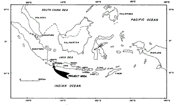
Figure 1. Study area location
The Saguling reservoir was built in 1985, and is one of four dams in the Upper Citarum watershed, with a capacity to generate approximately 700 megawatts of energy. Although the economic lifetime of the reservoir was estimated to be 51 years, the high volume of sedimentation due to forest clearance, soil erosion and inappropriate land use and management practices has reduced this estimation to around 45.4 years (JICA, 1993).
Method and Techniques
The methodological approach consisted of six main steps: (i) determine physical and economic land suitability of the area according to the land qualities of land mapping units, and land utilisation types (LUTs) proposed to satisfy the objectives of stake holders (i.e. farmers, government, commercial.plantation and hydroelectric companies); (ii) define quantitative development goals for specific development plans according to the projected demands of the local population basic needs, and land degradation control; (iii) determine goal coefficients for each LUT; (iv) set land use allocation scenarios according to projected development goals and the goal coefficients of selected LUTs within each LMU using IMGLP; (v) select the best land use allocation scenarios according to the preferences of decision makers using AHP; (vi) export the matrices of land use allocation scenario analysis to GIS, and join them with the digital LMUs for visualising spatial distribution of alternative spatial plans.
This paper focuses on steps (iv), (v), and (vi). Phases (i), (ii), and (iii) are discussed in detail in Suhaedi and Metternicht (2000)and Suhaedi et al. (2001), and briefly summarised hereafter. Based on physical data analysis (soil, geology, topography, and aerial photographs) at scale 1:100,000, field observations, and the geopedologic classification developed by Zinck (1988), twelve physiographic units were defined as land mapping units (LMUs) and their associated land characteristics were determined for the entire study area and stored in the digital database via digitising of the polygons’ boundaries (e.g. spatial attributes) and input of aspatial attributes in Dbase IV. These LMUs comprised: (1) flood plains, (2) alluvio-lacustrine plains, (3) colluvial plains, (4) volcanic plains, (5) alluvio-volcanic fan, (6) volcanic fans, (7) volcanic foot-slopes, (8) lower volcanic ridges, (9) middle volcanic ridges, (10) upper volcanic ridges, (11) hills, and (12) mountains. Using the guidelines for physical and socio-economic suitability developed by FAO (Rossiter, 1994), land suitability analysis was conducted for these 12 LMUs based on seven (7) proposed LUTs (e.g. irrigated rice, rainfed rice, dry land arable farming, mixed gardens, vegetables, tea plantations, and pine plantations). The results are summarised in Table 1, and the procedure adopted for the analysis is described in Suhaedi and Metternicht (2000).
Setting land use allocation scenarios according to projected development goals
Using a combination of field observations and experts’ opinions, goal coefficients were determined for the seven proposed LUTs within each of the LMUs as described in Suhaedi et al. (2001). Based on the projected development goals in the study area, and the goal coefficients resulting from the land suitability matrix, land use allocation scenarios in the study area were formulated for the year 2004, using IMGLP equations implemented in the software PcProg (Kalvenlagen, 1986), as follows:
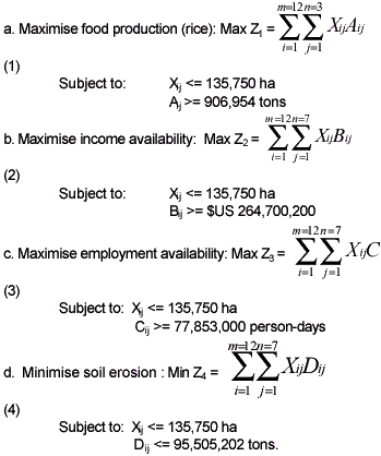
Where: Z1= maximising food production; Z2= maximising income availability, Z3= maximising employment availability; Z4= minimising soil erosion; i = the number of LMUs (12 LMUs were determined in the study area: flood plains, alluvio-lacustrine plains, colluvial plains, volcanic plains, alluvio-volcanic fan, volcanic fans, volcanic footslopes, lower volcanic ridges, middle volcanic ridges, upper volcanic ridges, hills, and.mountains); j = the number of LUTs (7 LUTs were selected: irrigated rice, rainfed rice, dry land arable farming, mixed gardens, vegetables, tea plantations, pine plantations); m = the number of LMUs classified as suitable for a given LUT (S1= highly suitable, S2 = moderately suitable, S3 = marginally suitable, N= not suitable); and n = the number of LUTs selected and allocated to a given LMU.

Design of Land Use Allocation Scenarios
The application of interactive multiple goal linear programming to the output of land suitability analysis on the study area produced ten feasible land use allocation scenarios. Five of these scenarios consider intervention to current land use management practices, whereas the remaining alternatives are based on a policy of no intervention to current management practices (Suhaedi, 2002). This paper uses the example of land use allocation without intervention to current management practices to illustrate the procedure adopted for selecting the best scenario. The preferences of decision makers were incorporated into the selection of the best scenario, using the analytic hierarchy process as described in Malczewski (1999) and Suhaedi (2002). Table 2 shows five alternatives modelled without interventi on to current management practices. For instance scenario-2 intends to maximise income generation (the first priority), while achieving a desired employment (the second priority), and food (the third priority) rates in year 2004. This scenario was set to maximise income generation for meeting the projected income demand of around $US 264,700,200. This required setting the goal of soil erosion equal to or more than zero tons ( no control in soil erosion), and then followed by the feasible values of the projected employment requirements of at least 65,000,000 person-days, and food requirements of at least 148,000 tons. After optimisation using IMGLP, the following goals were attained for scenario-2:
- Food around 148,000 tons rice which is around 758,954 tons lower than the required 906,954 tons rice;
- Income around $US 264,700,200, that is, the projected income requirements are achieved;
- Employment around 65,000,000 person-days, which is 12,853,200 lower than the projected employment requirements for year 2004;
- Soil erosion of around 106,071,812 tons, which means an increase in soil erosion of around 10,566,610 tons, as compared to soil erosion volumes computed for the year 2000 (e.g. estimated to be 95,505,202 tons).

Evaluation of Land Use Allocation Scenarios
Table 3 shows the preferences of decision makers (DMs) in relation to the four goals set in this study. Based on the AHP procedure (Malczewski, 1999), the values from step 1 were normalized in step-2, then standardized in step-3, obtaining the weight of each goal in the study area, as follows: employment at 0.5, soil erosion at 0.272, income at 0.138, and food at 0.09. These weights produced a consistency ratio (CR) equal to 0.057. According to Rasgadale (1997) a CR of less than 0.10, indicates a reasonable level of consistency in the pair-wise comparison. If the CR is larger than 0.10, the ratio indicates inconsistent judgments, hence the original values need to be revised.
To determine the best scenarios according to the decision makers’ preferences, the weights were attached to the goals’ value of each scenario, then the values were normalised, standardised, and ranked using the standard procedure of the AHP. Table 4 shows that based on the AHP analysis of the decision makers’ preferences for models without intervention to current land use management practices, scenario-1 was selected as the best land use scenario, followed by scenario-5, scenario-4, scenario-3, and scenario2. The spatial plan of the Saguling catchment area under scenario-1 is presented in Figure 2.
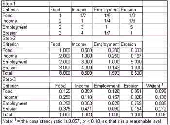
Table 4. Selection of Land Use Allocation Scenarios


Figure 2. The Spatial Plan of the Saguling Catchment Area Under Scenario-1
Discussion of Results and Conclusions
Based on the multiple goal analysis applied to the study area, several important issues were identified as follows:
- Soil erosion and food supply goals are complementary goals, that means at higher food demands, lower soil erosion rates were recorded;
- Soil erosion reduction, income, and employment goals, are conflicting goals that means that the lower the soil erosion, the lower the income and employment become. However, the conflict between soil erosion reduction and employment goals is lower than between soil erosion reduction and income generation. Due to the population growing rapidly, and the high demands of employment and income in the study area soil erosion remains a problem.
- It is recommended to promoting several programs in the study area: control over land use change programs for maintaining development goals, expansion of tea plantations in state-owned lands for creating more rural employment, and development of urban industry-based tea and pine plantations, and reforestation on sloping areas, particularly in forest protected areas for soil erosion control.
References
- Barredo, J. I. and Sendra, J.B., (1998) Multi-Criteria Evaluation Methods for Ordinal Data in a GIS environment. Geographical Systems, Vol.. 5, 313-327 pp.
- Huizing, H. and Bronsveld, K., (1994) Interactive Multiple Goal Analysis for Land Use Planning. ITC Journal, Vol. 4, pp. 366-373.
- JICA (1993) The Feasibility Study on Upland Plantation and Land Development Project at Citarik Sub Watershed, the Upper Citarum Watershed, West Java. Japan International Cooperation Agency (JICA), Bandung, Indonesia, 185 pp.
- Kalvenlagen, E. M. F (1986) Quantitative Management Software, PcProg Reference Manual, Erasmus University, Amsterdam, The Netherlands.
- Malczewski, J., (1999) GIS and Multicriteria Decision Analysis, John Wiley & Sons, New York, USA. 391 pp.
- Rossiter, D. G (1994) Land Evaluation, Cornell University, New York, USA, 232 pp. Suhaedi, E. and G. Metternicht (2000). Integrated Automatic Land Evaluation and Geographic Information Systems for Mapping Land Suitability. Proc. of the Mapping Sciences Conference 2000, Sydney, New South Wales 3-6 December 2000, pp 231-245.
- Suhaedi, E., G. Metternicht, and G. Lodwick (2001). Integrated Multicriteria Decision Making and Geographic Information Systems for Spatial Planning of Rural Areas. Proceedings of The Third International Conference on Geospatial Information in Agriculture and Forestry, Denver, USA. CD-Room, Paper 1-4, 12 pp.
- Suhaedi, E (2002) Models of Spatial Planning For Sustainable Rural Development. PhD Thesis, Department of Spatial Sciences, School of Resource Science, Curtin University of Technology, Perth, Australia, 279 pp.
- Wise, S., Haining, R. and Jingsheng, M. (2001) Providing Spatial Statistical Data Analysis Functionality for the GIS user: the SAGE project. International Journal Geographical Information Science Vol. 3: pp. 239-254.
- Zinck, J. A (1988). Soil Survey Courses, International Institute for Aerospace Survey and Earth Sciences. Enschede, The Netherlands, 156 pp.