| GISdevelopment.net ---> AARS ---> ACRS 2002 ---> Land Use/Land Cover |
An agricultural Land Use
analysis by the spatial integration data map
Kiyoyuki
Yaota
Research Fellow of the Japan Society for the Promotion of Science
Takashi Takebe
Graduate School of Agriculture, Kyoto University
Dept. of Agric. Economics, Graduate School of Agriculture
Kyoto University, Oiwake-cho, Kitasirakawa
Sakyo, Kyoto Japan 606-8502 Tel: +81-75-753 -6459
Fax: +81-75-753-6459
E-mail: mailto:yaota@kais.kyoto-%20u.ac.jp
Kiyoshi Torii
Graduate School of Agriculture, Kyoto University
Dept. of Agric. Economics, Graduate School of Agriculture
Kyoto University, Oiwake-cho, Kitasirakawa
Sakyo, Kyoto , Japan 606-8502
Tel: +81-75-753 -6459
Fax: +81-75-753-6459
E-mail: mailto:yaota@kais.kyoto-%20u.ac.jp
Yoshiaki Mori
Graduate School of Agriculture, Kyoto University
Dept. of Agric. Economics, Graduate School of Agriculture
Kyoto University, Oiwake-cho, Kitasirakawa, Sakyo
Kyoto , Japan 606-8502
Tel: +81-75-753 -6459
Fax: +81-75-753-6459
E-mail: mailto:yaota@kais.kyoto-%20u.ac.jp
Abstract
At present, increase in cultivation -abandoned areas due to aging of farmers and shortage of successors is raising a trouble in the Japanese farm villages. The agricultural land where cultivation is given up continues to occur in spite of law maintenance and dealing of the local governments and agricultural cooperative associations.
Concerning rice fields, on the other hand, a contradiction exists in that the production adjustment demands a change in crops in the area of a fixed rate even if a condition is good. To pursue the efficiency in the use of agricultural lands in such conditions, a data map which provides information on the detailed agricultural lands, farmers’ individual attributes, and so on is needed. One of the objectives of this research is to analyze occurrences of cultivation-abandoned areas and the conditions of changing crops in individual farmlands by using satellite images, the aerial photographs and agricultural land information.
Introduction
In Japanese agricultural management, the use of machines increased the number of person who does farming on the side and accelerated to find works in another industry, though that contributed to save many labor inputs. Today, the result of continue that situation, aging of farmers and shortage of successors increased cultivation-abandoned fields in many agriculture area. Concerning rice fields, the improvement of productivity was planed by the “agricultural structure improvement project” which change fields from small and various form to bigger and square, but the production adjustment makes a part of then changing crop fields and non-cultivate areas.
The non- cultivate areas, especially cultivation- abandoned fields affect around fields in the problems of weeds and harmful insects, so it is important problem in agriculture land policy to control this area in the future. All cultivation- abandoned fields doesn’t stable, however, it is impossible to get accurate information in farmland register. In this paper, we try to get the information in rice field by using Ikonos satellite image.
Analysis Area
The analysis area is one city in Nara prefecture. This city is near by big consumption area as Osaka and Nara city, being organized 17 agricultural communities, and the agriculture is important section here. Fig.1 express the change of agriculture management area from agriculture census data in every agricultural community, every five years. In every community, different trends are there, but it is clear that the degreasing in recent years is remarkable.
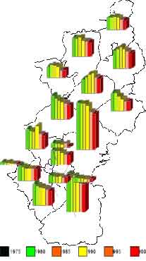
Fig 1. Change of farm management area
Analysis of land classification
- Data Structure
Fig.2 explain the structure of analysis data map, which we built in this study. The survey maps are vector data and made based on acreage investigation and agricultural structure improvement project, but all city areas don’t include in it. Because there are gaps between survey maps and Ikonos satellite image, we correct the latter based on survey maps in the view of accuracy. Fig.3 show the analysis area extracted from corrected Ikonos satellite image. The attribute data of farmland register include not only square but also much information like as land category and owner.
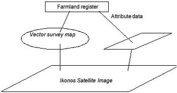
Fig 2. Stucture of data map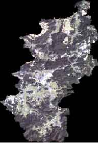
Fig 3. Ikonos Image of object area
- Classify for the whole Area
We classified Ikonos satellite image of whole city by supervised classification . Fig.4 show one result of classifies. By using this image, we can get topographic information, but farmland was included in forest category, so evaluated more narrow. We can’t get about land category.
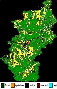
Fig 4. Result of supervised classfication
- Classify for the project area
Next we extracted the area of agricultural structure improvement project from Ikonos satellite image by suing vector survey map to recognize more detailed agriculture land use situation (Fig.5). Fig.6 is one.result of unsupervised classification of Fig.5. We can understand there are changing crop areas in this image, although the object of this project is preparation as rice field. Moreover, this image give us differences in rice field, there are possibility of existing cultivation-abandoned fields and non- cultivate areas.
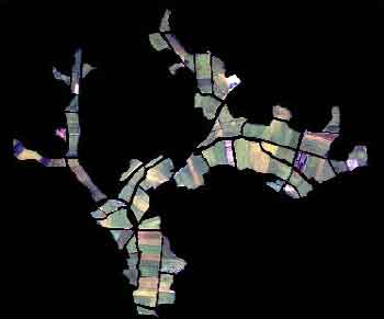
Fig 5. Extract image by project map
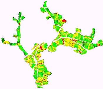
Fig 6. Result of unsupervised classification of fig 5
Conclusion
In this study, we try to recognize cultivation- abandoned fields and non- cultivate areas those are one of most important agriculture land policies in Japan. As a result, it is cleared that there are possibilities of contribute for grasp those areas by using detail map data like as agricultural structure improvement project map, which can extract agriculture land per individual fields.
Reference
- Nariyuki Ohbayashi, Naohito Kojima, Remote censing for a businessman, Fuji-Technosystem co., 2002.1975 1980 1985 1990 1995 2000