| GISdevelopment.net ---> AARS ---> ACRS 2002 ---> Land Use/Land Cover |
Land cover classification and
interpretation of NASA / JPL AIRSAR data based on scattering mechanisms
and statistical distribution
Ken Yoong LEE
Centre for Remote Imaging, Sensing and Processing
National University of Singapore
Block SOC1, Level 2
Lower Kent Ridge Road
Singapore 119260
Tel: (65) 6874 8029
Fax: (65) 6775 7717
E-mail: crsleeky@nus.edu.sg
Soo Chin LIEW
Centre for Remote Imaging, Sensing and Processing
National University of Singapore
Block SOC1, Level 2
Lower Kent Ridge Road
Singapore 119260
Tel: (65) 6874 8029
Fax: (65) 6775 7717
E-mail: crslsc@nus.edu.sg
Leong Keong KWOH
Centre for Remote Imaging, Sensing and Processing
National University of Singapore
Block SOC1, Level 2
Lower Kent Ridge Road
Singapore 119260
Tel: (65) 6874 8029
Fax: (65) 6775 7717
E-mail: crsklk@nus.edu.sg
Centre for Remote Imaging, Sensing and Processing
National University of Singapore
Block SOC1, Level 2
Lower Kent Ridge Road
Singapore 119260
Tel: (65) 6874 8029
Fax: (65) 6775 7717
E-mail: crsleeky@nus.edu.sg
Soo Chin LIEW
Centre for Remote Imaging, Sensing and Processing
National University of Singapore
Block SOC1, Level 2
Lower Kent Ridge Road
Singapore 119260
Tel: (65) 6874 8029
Fax: (65) 6775 7717
E-mail: crslsc@nus.edu.sg
Leong Keong KWOH
Centre for Remote Imaging, Sensing and Processing
National University of Singapore
Block SOC1, Level 2
Lower Kent Ridge Road
Singapore 119260
Tel: (65) 6874 8029
Fax: (65) 6775 7717
E-mail: crsklk@nus.edu.sg
Abstract
In previous work (Lee et. al, 2001), we have shown the land cover classification of NASA / JPL single-frequency C- and L-band fully polarimetric POLSAR data over the northern part of Peninsular Malaysia, based on both physical and statistical properties. Further extension on various frequency and polarization combinations was investigated and reported in this paper. In unsupervised classification, the scattering mechanism of each pixel in Lee polarimetric filtered images was analyzed using Cloude and Pottier's target decomposition theorem and Van Zyl approach, respectively. The supervised complex Wishart classifier was used to classify the following inputs: multifrequency fully polarimetric SAR, single-frequency fully polarimetric SAR, and dual-polarization complex SAR. For single-frequency and single-polarization SAR intensity data, the supervised Maximum Likelihood classification was performed based on Gamma distribution. The Kappa statistics computed for classification using single-frequency fully polarimetric C- and L-band data were 0.69 and 0.73, respectively. An improvement to 0.79 was achieved by combining C- and L-bands fully polarimetric data in the classification. Only a limited number of land cover classes could be discriminated from C- and L -band intensity data.
Introduction
Spaceborne remote sensing has long been an appropriate and effective data source for land cover mapping due to the wide coverage and repetitive observations (Haack and English, 1996). In general, there exist two major types of remotely sensed data: optical and synthetic aperture radar (SAR). Both optical and SAR data, however, have certain problems in their applications in mapping the tropical regions. The occurrence of extensive clouds is the main problem of the optical remote sensing data. As clouds interfere with the reception of optical sensors, its presence consequently causes the loss of land cover information in the captured data. At present, only single-frequency and single-polarization SAR is currently available on space-platforms such as the ERS 1/2 and RADARSAT-1. Land cover classification using single-frequency single-polarization SAR data is difficult due to the poor separability.of different land cover features. Nevertheless, with the advent of multifrequency and multipolarization SAR system, it is now possible to capture the full-polarimetric signatures of the earth surface, enabling a more accurate classification of the various land cover types (Boerner et. al, 1998). The ASAR instrument on-board the recently launched ENVISAT satellite has the capability of performing alternating polarization SAR. Other upcoming satellites that promise full-polarimetric SAR imaging capabilities include RADARSAT-2 and ALOS. The POLSAR data acquired during the NASA / JPL AIRSAR missions provide an opportunity to investigate the capability of multifrequency and multipolarization SAR in land cover classification. An attempt is made, in this study, to investigate and optimize the use of multifrequency and multipolarization SAR data for land cover classification over tropical region. The classification was carried out based upon the physical (i.e. scattering mechanism) and statistical properties in the POLSAR data. Focus is placed on the C- and L -band POLSAR data.
This paper is organized as follows: Sections 2 and 3 present the test area selected and data acquired for this study. In Section 4, the speckle suppression and classification of POLSAR data are discussed. Section 5 analyzes the results obtained. Concluding remarks are given in Section 6.
Study Area
The test site identified for this study is an agricultural inland region covering an area of approximately 100 km2 in the northwest of Peninsular Malaysia near Jitra (Figure 1a). It extends from 6° 11’ to 6° 17’ N latitude and 100° 21’ to 100° 26’ E longitude. The topography is characterized by flat and undulating terrain, with an elevation of approximately 2.5m. The large portions of the site are the irrigated lands, predominately cultivated with rice paddy. Other land cover features, such as rubber plantations, grassland, highway, runway, built-up area, and river, can also be found in the study area. During the 1996 AIRSAR PACRIM Deployment, the site was selected by the Malaysian Centre for Remote Sensing (MACRES) for land use and rice crop study (Lou et. al, 1997).
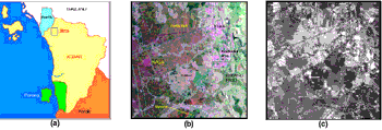
Figure 1: Location map of Jitra, Kedah (a) and the corresponding Lee polarimetric filtered (5x5) POLSAR data (b) as well as the SPOT-1 panchromatic data (c)
Data Acquisition
The data used in this study was provided by NASA / JPL. The POLSAR data, with C- (5.7 cm), L- (25 cm) and P- (68 cm) bands in full polarization (HH, HV, and VV), was acquired using the AIRSAR instrument on-board a DC-8 aircraft during the PACRIM-1 mission on 3rd December 1996. The aircraft flew at nearly 9 km during data collection. The incidence angles were 24þ for near range and 60þ for far range corresponding to the near and far ranges of 10 and 20 km, respectively. The 18-looks POLSAR data supplied by NASA / JPL was projected into ground range with a ground pixel spacing of 10 meters. Only C- and L-bands (both in Compressed Stokes Matrix format) were examined in this study. A cloud-free SPOT-1 scene of the same area was also acquired and processed by CRISP (Figure 1c). The 10 meters resolution SPOT panchromatic image was acquired on 18th January 1997 and processed to Level 2A. It was used together with the existing topographical and land use maps for locating the test sites.
Methods and Implementation
1. Speckle Suppression Using Polarimetric Filters
The POLSAR images (in complex covariance matrix form) were filtered using two polarimetric filters, namely Lee (Lee et. al, 1999) and Mean (also known as “boxcar”). Window sizes of 3x3, 5x5, 7x7, were tested and analyzed. The performance of both polarimetric filters was assessed in terms of speckle suppression, edge enhancement, and preservation of polarization signatures (Lee et. al, 2001b). Comparing both Lee and Mean filters, the former was found to be more superior to the latter. Hence, the Lee filtered images of both C- and L-bands using 5x5 window were selected and employed in the subsequent classification process.
2. Unsupervised Classification of Scattering Mechanisms There are two different approaches of unsupervised classification carried out in this study. First, the van Zyl approach was used to classify the Lee filtered image pixels into three categories: (1) odd number of reflections, (2) even number of reflections, and (3) diffuse scattering. To define the scattering behavior of each pixel, the classification involved the use of the elements of Muller matrix. Detailed discussions on the Muller matrix appear in van Zyl (1989). Each scattering category obtained was then further separated into two groups: |HH|2>|VV|2and |HH|2<|VV|2. Figures 2(a) and 2(b) show the classification outcomes using C- and L -bands, respectively.
Second, the Cloude and Pottier’s target decomposition theorem was studied and employed to group all pixels into nine different zones (or nine classes) accordingly to the partitioning of the entropy (H)-alpha (x) plane. The decomposition is based on the eigenvalue analysis of the complex coherency matrix T, which is based on Pauli matrix representation. The physical scattering characteristics of each zone are explained in detail in Cloude and Pottier (1997). Figures 3(a) and 3(b) give the C- and L-band classification outputs resulting from the target decomposition in H-þ plane, respectively.
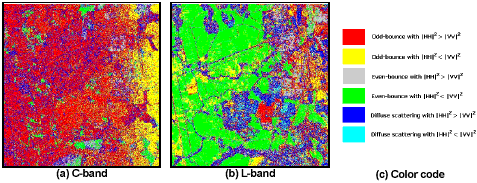
Figure 2: Unsupervised classification results based on van Zyl approach
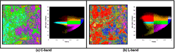
Figure 3: Unsupervised classification results based on target decomposition in H- þ þ plane.4.3 Supervised Classification Based on Statistical Distribution
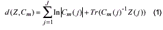
In supervised classification, the complex Wishart classifier (Lee et. al, 2001a) was used to classify the following inputs: multifrequency fully polarimetric SAR, single-frequency fully polarimetric SAR, and dual-polarization complex SAR. The complex covariance matrix Z (a Hermitian matrix) of candidate pixel P was used to compute its distance to target classm. The distance measure is defined by
where C is the mean covariance matrix for target class m. The pixel P is assigned to target class with the minimum distance measured. J refers to the total number of bands where J = 2 for the classification of multifrequency fully polarimetric SAR because of the combination of C- and L-bands, and J = 1 for the single-frequency fully polarimetric SAR and dual-polarization complex SAR in this study. The order of the covariance matrix is 3× 3 for both multifrequency and single-frequency fully polarimetric SAR, whilst it is 2× 2 in the case of dual-polarization complex SAR.
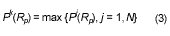
For the single-frequency and single-polarization SAR intensity data, the supervised Maximum Likelihood classification was performed based on Gamma distribution (Nezry et. al, 1996).
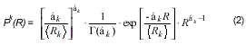
where Rk represents the mean radar reflectivity and sk = {Rk/sk}2 wheresk is the standard deviation of R in class k. A pixel P of radar reflectivity Rp is attributed to class k (among the N separable target classes) which maximizes the N discriminating functions.
In this study, the training samples were generated from the unsupervised outputs of the target decomposition. Figure 4 presents the supervised classification results of C- and L-band images.
(a) combined C and L (b) L-band (c) L-band HV and VV (d) L-bandHH (e) C-band (f) C-band HH and HV (g) C-band HH (h) Color code
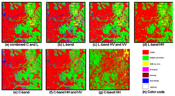
Figure 4: Supervised classification results of multifrequency fully polarimetric (a), single-frequency fully polarimetric (b, e), dual polarization complex (c, f), and single-frequency intensity data (d, g)
Results and Discussion
In Figure 2(b) showing the results of unsupervised classification based on the scattering mechanisms, the rice paddy and built-up area in L-band data were categorized into the even-bounce class whilst the rubber plantation was dominated by diffuse scattering. The grassland, highway, and runway which exhibit specular scattering fell into the odd-bounce class. The canal and river gave both odd-bounce and diffuse scattering. While single bounce was expected due to scattering from the water surface, the diffuse scattering was mainly contributed by the trees and scrubs along the sides of the waterways. In this study, it was found that both rice paddy and built-up area in L-band data could be further separated. The paddy showed higher backscattered intensity in VV (versus HH) whilst HH has higher intensity in the built-up area. The result obtained was identical to Yamada and Hoshi (2001). For the C-band shown in Figure 2(a), all land cover features, excluding built-up area, were characterized as having the odd-bounce scattering behavior. The runway was successfully separated from the surrounding grassland through the comparison of |HH|2and |VV|2
Table 1 presents the percent of scattering mechanisms of land cover classes in both the C- and L -band data. As can be seen in Figure 3(b), the paddy and built-up area in L-band data were classified as having multiple scattering. The major scattering mechanism of the paddy belonged to the type of low entropy scattering whilst the built-up area, as expected, showed both low (25%) and medium (48%) entropy scattering. In L-band, the rubber was dominated by high entropy vegetation scattering while it exhibited the medium entropy surface scattering in C-band. The runway was categorized into the class of medium entropy surface scattering for both C- and L-bands. For the canal and river, the dominant scattering was medium entropy vegetation scattering. The grassland gave medium entropy vegetation (50%) and surface (61%) scatterings respectively in both C- and L-bands. The percent of scattering mechanisms of land cover classes, derived from the target decomposition for C- and L -band data is given in Table 2. For the supervised classified results, the overall accuracy and Kappa statistics (Congalton and Green, 1999) were computed and are tabulated in Table 3. The classification results obtained were promising where the correct classification of land cover classes was more than 70% for both C- and L-bands. With the longer wavelength, the L-band data showed more distinct discrimination between land cover classes and thus gave the better classification performance compared to the C-band. Nevertheless, from Figures 4b and 4e, it was clearly observed that the highway was misclassified into the waterbody class due to their poor separation in both C- and L-band data. An improved accuracy of 83% was derived from the combined dual frequency (C and L bands) fully polarimetric SAR data. For the single-frequency dual polarization complex images, the HH and HV combination in the C-band and the L-band HV and VV combination gave better results compared to the other polarization compositions. Only a limited number of classes could be discriminated from the C- or L-band single intensity images. The HV polarization showed its excellence in classifying both the rice paddy and rubber plantation classes, but was not good for discriminating built-up area compared to HH and VV polarizations. Among all polarizations, HH polarization produced the highest accuracy.
Conclusions
In this study, we have shown the unsupervised classification of NASA/ JPL POLSAR data through two different approaches: van Zyl method and Cloude and Pottier’s target decomposition. Also, the various frequency and polarization combinations of POLSAR data were investigated in the supervised classification. For single-frequency and single-polarization SAR intensity data, the supervised Maximum Likelihood classification was performed based on Gamma distribution. Whilst, the supervised complex Wishart classifier was used to classify the following inputs: multifrequency fully polarimetric SAR, single-frequency fully polarimetric SAR, and dual-polarization complex SAR. The C- and L-band POLSAR data have proven to be useful in land cover classification, especially for paddy class. An overall accuracy of 78% was shown by the L-band while the accuracy achieved by C-band was 75%. The use of the combined C- and L-bands fully polarimetric data, as expected, increased the accuracy to 83%. Only a limited number of land cover classes could be discriminated from C - and L -band intensity data.
Acknowledgement
The NASA / JPL is gratefully acknowledged for providing the POLSAR data.
References
- Boerner, W.-M., Mott, H., Luneburg, E., Livingstone, C., Brisco, B., Brown, R. J., Paterson, J. S., Cloude, S. R., Krogager, E., Lee, J. S., Schuler, D. L., van Zyl, J. J., Randall, D., Budkewitsch, P., and Pottier, E., 1998. Polarimetry in Radar Remote Sensing: Basic and Applied Concepts. In: Manual of Remote Sensing - Principles and Applications of Imaging Radar, edited by Henderson, F. M. and Lewis, A. J., John Wiley and Sons, Inc., The United States of America, pp. 271-357.
- Cloude, S. R. and Pottier, E., 1997. An entropy based classification scheme for applications of polarimetric SAR. IEEE Transactions on Geoscience and Remote Sensing, 35 (1), pp. 68-78.
- Congalton, R. G. and Green, K., 1999. Assessing the Accuracy of Remotely Sensed Data: Principles and Practices. CRC Press, Inc., The United States of America, pp. 43-63.
- Haack, B. and English, R., 1996. National land cover mapping by remote sensing. World Development, 24(5), pp. 845-855.
- Lee, J. S., Grunes, M. R., and de Grandi G., 1999. Polarimetric SAR speckle filtering and its implication for classification. IEEE Transactions on Geoscience and Remote Sensing, 37 (5), pp. 2363-2373.
- Lee, J. S., Grunes, M. R., and Pottier, E., 2001a. Quantitative comparison of classification capability: fully polarimetric versus dual and single-polarization SAR. IEEE Transactions on Geoscience and Remote Sensing, 39 (11), pp. 2343-2351.
- Lee, K. Y., Liew, S. C., Kwoh, L. K., and Nakayama, M., 2001b. Land Cover Classification Using NASA / JPL Polarimetric Synthetic Aperture Radar (POLSAR) Data. In: Proceedings of Asian Conference on Remote Sensing, Singapore, Vol. 2, pp. 1049-1054.
- Lou, Y., Kim, Y., van Zyl, J. J., Maldonado, L., Miller, T., O’Leary, E., Romero, G., Skotnicki, W., and
- Taylor, V., 1997. The NASA / JPL Airborne Synthetic Aperture Radar’s 1996 PacRim Deployment. In: IEEE International Geoscience and Remote Sensing Symposium Proceedings, Vol. 3, pp. 1404-1406.
- Nezry, E., Lopes, A., Ducrot-Gambart, D., Nezry, C., and Lee, J.-S., 1996. Supervised classification of K-distributed SAR images of natural targets and probability of error estimation. IEEE Transactions on Geoscience and Remote Sensing, 34 (5), pp. 1233– 1242.
- van Zyl, J. J., 1989. Unsupervised Classification of Scattering Behavior Using Radar Polarimetry Data. IEEE Transactions on Geoscience and Remote Sensing, 27(1), pp. 36-45.
- Yamada, T. and Hoshi, T., 2001. Expansion of the Unsupervised Classification of Polarimetric SAR Images Based on the Scattering Types Using the Shape Features of Polarization Signature Diagrams. In: Proceedings of Asian Conference on Remote Sensing, Singapore, Vol. 2, pp. 1055-1060.