| GISdevelopment.net ---> AARS ---> ACRS 2002 ---> Land Use/Land Cover |
Short- Term change detection
with precise geometric correction and sub-pixel land cover
characterization of modis
Kei Oyoshi, Wataru
Takeuchi, Yoshifumi Yasuoka
Institute of Industrial Science, University of Tokyo
4-6-1 Komaba, Meguro, Tokyo 153- 8505
Tell: (81)- 3-5452-6417
Fax: (81) -3 5452-6414
E-mail: mailto:kooyoshi@iis.u-%20tokyo.ac.jp
Japan
Institute of Industrial Science, University of Tokyo
4-6-1 Komaba, Meguro, Tokyo 153- 8505
Tell: (81)- 3-5452-6417
Fax: (81) -3 5452-6414
E-mail: mailto:kooyoshi@iis.u-%20tokyo.ac.jp
Japan
Abstract
Earth observation satellite Terra was launched in 1999. High spatial resolution and high frequency observation capability of Terra/MODIS ensures that every point on our world is observed every 1 – 2 days in 36 discrete spectral channels. MODIS is, therefore, expected to monitor short- term changes of earth’s surface in more detail. This research develops sub-pixel scale image comparison algorithm for MODIS 250m data to detect small scale land cover changes. For sub-pixel scale image comparison, a spectral mixture analysis was developed based on the linear mixture model. This algorithm made it possible to compare the land- cover category mixing ratio within the same pixel in the two different date images and detect the sub-pixel scale changes in land cover. Firstly, pattern matching was conducted to validate the accuracy of geometric correction by WebMODIS system. The result shows the accuracy to be quite satisfactory. Secondly, short- term land-cover change was examined by linear mixture model. But, the differences of slope effect, atmospheric conditions and mis-registration caused a lot of noise errors. Finally, by applying the filtering algorithm and setting threshold, mis-detection reduced effectively and short- time land cover change was detected with quite high in pixel level.
Introduction
Land cover change is interface of environmental changes. Since land cover change induced by human activities causes variation in temperature, atmosphere, or ecosystem and so on. It is important to monitor land cover change. Remote sensing established itself to be the most effective tool to do that, as it can get the surface information extensively, simultaneously, periodically and quickly. High spatial resolution and high frequency observation capability of MODIS as earth observation satellite launched in 1999, ensures observing the same area almost everyday with a spatial resolution of 250m in visible and near infrared channels. Presently, there is no sensor to monitor short- term land cover changes as detailed as MODIS. MODIS is expected to monitor short-term land cover changes, for example disasters, illegal dumping, rice harvesting and so on, in more detail at the earth surface. For detecting small scale changes in urban areas or complicated landscape areas from MODIS images, precise geometric correction is necessary to overlay time series satellite images exactly and to identify the same areas in two images. Sub-pixel level comparison of land-cover characteristics will be needed to detect changes in the pixel of 250m. In this case, detecting small scale changes in urban areas or complicated landscape areas by using the different date MODIS images, precise geometric correction is indispensable to overlay a pair of satellite images exactly and to identify the same areas in two images. The objects of this research are to examine the accuracy of geometric correction by pattern matching and to develop the algorithm for short-term land cover change detections in sub -pixel level to detect change.
Modis Data used in this study
Institute of Industrial Science (IIS), University of Tokyo has been receiving and archiving MODIS data since May 2001. IIS has started to process and distribute MODIS data through the web for the benefit of the scientific community at WebMODIS, “http://webmodis.iis.u-tokyo.ac.jp/”, since Sep. 2002. This system provides spatially subset data based on the request of end - users. We downloaded cloud-free MODIS data acquired on 10 Mar. 2002 and 12 Mar. 2002. Both data has two channels with 250m spatial resolution. Digital counts were converted to radiance followed by geometric correction. The study area in a 300 x 300km area in the Kanto district of Japan, as shown in Fig.1. Fig.2. shows the MODIS image of the study area for 10 Mar. 2002.
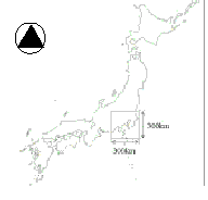
Fig 1. Kanto district in Japan
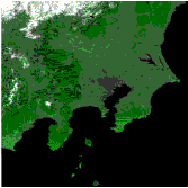
Fig 2. MODIS image (visible and near infrared channels) of study area. 10 Mar. 2002
Methodology
1. Examination of geometric correction accuracy
Detecting change in sub-pixel level requires precise overlay between different images. It depends on the accuracy of geometric correction of each image. Firstly, the accuracy of geometric correction done by WebMODIS is examined by pattern matching. NDVI images were used to conduct pattern matching. As matching piece should have a characteristic shape, Oshima and lake Kasumigaura in the study area are selected. NDVI images of these two areas are shown in Fig.3. Correlation coefficients are calculated between the matching piece and 300 x 300 km2 coverage.
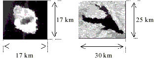
Fig.3. NSM images of matching pice (left:Oshima, right:Kasumigaura)
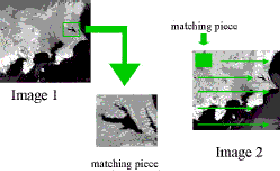
Fig.4. Process of pattern matching
2. Linear mixture modeling
MODIS is one of the few space-borne sensors currently capable of acquiring radiometric data over a broad range of view angles. However, the relatively coarse spatial resolution of the MODIS most often results in measurements of mixed land covers, and thus the pixel unmixing is indispensable. A linear spectral mixture model based on three end-members including vegetation, soil and water is defined by the equations and constraints below
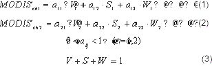
where MODIS ch1 , MODIS ch2 are the MODIS radiance of visible and near infrared channels respectively, and V, S and W are the fractional coverage of vegetation, soil and water respectively. ij a are the end-members and range from 0 to 1.
The number of equations equal to three by incorporating the constraint equation (Eqn.3) in order to calculate the fractional coverage V, S and W. Eqn.3 represents that the sum of three fractions in one pixel equals to 1. By solving three equations (Eqn.1, 2 and 3) simultaneously, we can calculate the fractional coverage of V, S and W.
3. Endmember selection
A mixture model based on three end-members has the simple geometrical interpretation as the triangle whose vertices are the end -members (Fig.5). Since a finite number of hull facets has only finitely many partitions, there are only finitely many simplexes the method can construct, and finding the one with the smallest volume is a combinatorial optimization problem. The triangle is defined to include 95 % of convex hull to eliminate the exceptional noisy pixels. Fig.6 shows the scatter plot for red and near infrared spectral distribution of MODIS image acquired on 10 Mar. 2002. The vertices of the triangle is defined as follows
- Vegetation : highest value in near infrared reflectance
- Soil : highest value in red reflectance
- Water : lowest value in both red and near infrared reflectance.
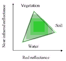
Fig 5. Relationship between VSW indices end-members triangle for Red-NIR
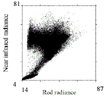
Fig 6. Scatter plot for Red-NIR on 2002.3.10
4. Change detection model and evaluation of land- cover change
Fractional coverage of vegetation, soil and water will be derived by spectral mixture analysis. In this study, we assume that there is no land cover change between the two scenes. In addition to that, it is assumed that there is mis-registration error of only one pixel between the two images. Using this assumption, a 3 x 3 filter as described hereafter is applied to reduce the errors. The spatial filtering will be applied to the V, S, and W images on 12 Mar. 2002. Fig.7 depicts the algorithm of the spatial filtering. The process is as follows:
- Select pixel in Image2 in around 9 pixel of (i, j) involved itself, such as minimize difference between the value and other pixel value (i , j) in Image1,
- The value of pixel (i , j) in Image2 is replaced selected pixel value,
- All pixel was done by these transaction and get Image2’ .
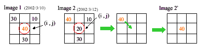
Fig 7. Filtering algorithm
Results and Discussion
1. Accuracy assessment of geometric correction by WebMODIS
Correlation coefficients were calculated between the matching pieces and the whole images of both MODIS data on 10 Mar. 2002 and 12 Mar. 2002. Fig.8. shows the result of the pattern matching. Best matching points are easily distinguished from the nearby pixels in these four pairs. Best matching points for both Kasumigaura and Oshima were same. This result shows that the accuracy of geometric correction by WebMODIS is high in pixel level.
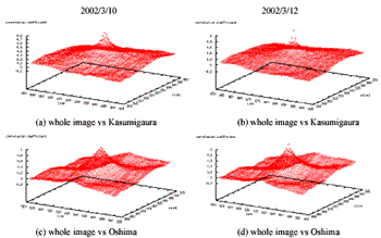
Fig 8. Result of pattern matching
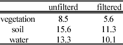
Table1. RMSE of percentage for filtered and unfiltered image
Results of change detection
Root mean squared errors (RMSE) are calculated between the six pair of V, S and W images both filtered and unfiltered images. The result is shown in Table1. RMSE of filtered images decreased in three categories compared with unfiltered ones. This result shows filtering algorithm was performed well to reduce the noise originated from the mis-registration. The derived three RMSEs of filterd images were selected as threshold values for the land cover change detection.
Fig.9 shows the subtracted images between 10 Mar. 2002 and unfiltered 12 Mar. 2002 images for V, S, and W respectively. Fig.10 shows the subtracted image for filtered images for V, S, and W respectively. Bright values indicate areas of high errors of that category. Flat region (white circle in Fig.9(a)) has comparatively smaller noise and mountainous region shows higher noise. The error images in Fig.9 and the corresponding digital elevation model (Fig.11) are clearly similar. This implies that differences of the slope effect strongly affected the result. To increase the accuracy of short-term land cover change detections, it is necessary to reduce differences of slope effect, cloud screening, atmospheric conditions and mis-registrations. However, the proposed method was able to detect short- term land cover changes with high accuracy.
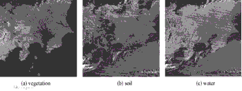
Fig.9. Subtracted images between 10 Mar. 2002 and unfiltered 12 Mar. 2002 images
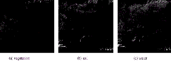
Fig.10. Subtracted images between 10 Mar. 2002 and filtered 12 Mar. 2002 images
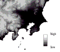
Fig.11 Digital elevation map (DEM) of study area (300 x 300 km 2 )
Conclusions
This research examined the possibilityof detecting short-term land cover change using MODIS images with spatial resolution of 250m in visible and near infrared channels. Firstly, pattern matching was used to evaluate the accuracy of geometric correction by WebMODIS. As a result, it is verified that the accuracy was within one pixel for the study area. Secondly, short- term land cover change detection was performed by.using the simple subtractive operation in sub- pixel based land cover characterization and the spatial filtering technique. As a result, errors were found in mountainous area for unfiltered images, and the error images were quite similar to digital elevation model. The differences of slope effect, atmospheric conditions and mis-registration may cause a lot of mis-detection. However, the filtering operation performed well to reduce the errors originated from the mis-registration. In this scene, the proposed method was able to detect short- term land cover change in pixel level with high accuracy. However, some mis-detection still remained. It is necessary to remove difference of slope effect, atmospheric conditions and mis-registration to improve accuracy of short-term land cover change detections. Since it is assumed that there is no change between two image because of their short-term- difference, this paper only discuss how to reduce the noise related with mis-registration. As a future work, the other errors should be examined regarding the Sun-Target- Sensor Geometry problems.
Acknowledgments
A part of this work was supported by ACT-JST “Research and Development for Applying Advanced Computational Science and Technology of Japan Science and Technology Corporation”.
References
- WebMODIS home page, http://webmodis.iis.u- tokyo.ac.jp/, (20 Oct. 2002 Access) Y.Yamagata, M.Sugita and Y.Yasuoka, 1997, Development of VSW index algorithm and application (in Japanese), Journal of the Remote Sensing Society of Japan, Vol.17, No.1, pp.54 -63.