| GISdevelopment.net ---> AARS ---> ACRS 2002 ---> Hazard Mitigation and Disaster Management |
A geographically encoded
locust impact minimization information system (Geo-LIMIS) for west
Kazakhstan
Duncan Wood, Adrian
McCardle
RADARSAT International, 13800 Commerce Parkway, Richmond, B.C. Canada V6Y 1Z3
Ph-604 231 4980
Fax-604 231-4900
email: dwood@rsi.ca
Dibyendu Dutta, Shantanu Bhatawdekar
Regional Remote Sensing Service Centre (RRSSC), CAZRI Campus, Jodhpur
Edige Zakarin, Lev Spivak
Space Research Institute of Kazakhstan, Ministry of Education and Science
Almaty, Kazakhstan
Abstract
Kazakhstan is a major crop exporter in Central Asia. Dependable agricultural production significantly affects food security within the country, as well as that of other countries in the region. Locust infestation is an annual occurrence, but the scale and intensity of the problem in recent years has reached a crisis level. In a United Nations Food and Agricultural Organization (FAO) report, the 1999 locust plague caused severe localized damage to crops in Kazakhstan despite best efforts to control the disaster.
The Department of Space, Government of India together with RADARSAT International, the Canadian International Development Agency (CIDA), and the Space Research Institute of Kazakhstan have developed a model to identify areas of locust risk within west Kazakhstan.
Introduction
The Republic of Kazakhstan is the second largest of the Independent states of the former Soviet Union, next to Russia and a major crop exporter in Central Asia. The country has an abundance of rangeland, mostly grazed by livestock; cattle, sheep, and goats. During the times of the former Soviet Union, Kazakhstan was the centre of agricultural production with it’s large steppe land suitable for wheat growing. As a result of the abrupt institutional changes surrounding the break up of the Soviet Union, Kazakhstan underwent large changes in agricultural production and subsequently the demand for wheat from Kazakhstan decreased and many of the wheat fields began to lay fallow. Typical ploughing and planting practices associated with wheat production were able to control the locust outbreaks during intense agricultural production, however, in recent years the country has seen a marked increase in locust outbreaks and the problem continues to worsen.
Although the locust infestation was a problem for most of the last decade, it has sharply increased since 1997, with serious effects for agricultural production. There are at least a dozen migratory sub species of locust, each bio-ecologically adapted to the specific eco-climatic conditions of their environments. Migratory locusts seek optimal temperatures of 20 – 25° C, with approximately 50-100mm of rainfall per month, and colonize areas of steppe and savannah where there is little or no tree cover.
The goals of the project were to:
- Establish a Geographic Information System, which would become the basis of a Locust Management System.
- Develop a local capacity to operate the system and extend the service throughout Kazakhstan and elsewhere in the region.
1. Study area and background
West Kazakhstan is characterized by mixed prairie and forest or treeless prairie, primarily in the north and in the basin of the Ural River to the west. The majority of west Kazakhstan is classed as either semi-arid or desert. The terrain in these regions is relatively flat with most of the region lying between 200 and 300 meters above sea level, however, the Caspian Sea area includes some of the lowest elevations on Earth.
Very fertile soils characterize the lands from the far north down to the more infertile, alkaline soils of the middle and southern areas. The vast stretches of arable land in the northern plains are the most intensely cultivated and productive. Other cultivated areas fringe the mountains in the south and east; irrigation and reclamation, when feasible, extend along river valleys into the deserts. West Kazakhstan has a strong continental climate with summer temperatures reaching as high as 40° C during the day, and dropping to half that at night. Annual precipitation ranges from less than 100mm a year in the deserts to 1500mm in the mountains. Much of the summer rain on the steppes comes from violent thunderstorms, which often cause local flash floods.
The regions of Chingurlausky and Karatobe (figure 1), of the West Kazakhstan Oblast were chosen for this initial study as this area has been greatly affected by locust upsurges in recent years, most notably Italian prus and Asian migratory locust. In 2000, approximately half of the agricultural land of west Kazakhstan was affected by Asian and Italian locusts.
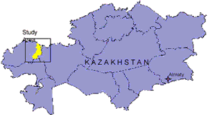
Figure 1. Location of study area in West Kazakhstan
In Kazakhstan, the Italian locust is by the far the most dangerous for Kazakhstan’s agricultural lands. Since 1995 the infested area has increased from about 1.1 million hectares to almost 2 million hectares.
2. Data and Locust Model
Land use data for the study area was derived from Landsat imagery acquired in 2001. Topographic information was created from Russian maps and updated using the Landsat imagery where necessary. Soil maps and locust ground data were supplied by the Space Research Institute of Kazakhstan and the Ministry of Agriculture respectively. Daily weather data was archived from the World Meteorological Organization (WMO) and consisted of minimum and maximum temperature, precipitation, and sunshine hours.
One of the key parameters in determining locust hatching is soil moisture. When the moisture and temperature conditions are conducive, the locust larvae may begin to hatch. For this project, RADARSAT satellite data were used to infer spatial measurements of soil moisture. The GEO-LIMIS model consists of three main modules (figure 2). The first of which is the Soil-landscape module that combines favorable land/soil types with geomorphological landform, soil texture, and soil salinity in order to identify the most suitable areas for locust breeding. Soil maps updated using a “soil brightness index” derived from Landsat-7 data

Figure 2. Schematic of the locust risk map creation in West Kazakhstan
The second component is the Biophysical module. A landuse / landcover layer was derived using Landsat 7 imagery. Both Landsat and MODIS data were also used to update the vegetative conditions within the study area. Due to cloud constraints, it was not possible to use the Landsat data to monitor vegetation conditions during the summer months. However, MODIS data was acquired throughout the summer growing season and composited to create weekly cloud free images. The third derived layer in this module is soil moisture. The soil moisture status was derived from RADARSAT-1 Standard 1 and 2 imagery throughout the summer. A satellite acquisition schedule together with dates of coincident ground measurements is presented in table 1.
| DATE | Beam mode | Orbit Region | Soil Moisture |
| 9-May-02 | Standard 1 | Ascending | Chingurlausky |
| 19-May-02 | Standard 2 | Ascending | Karatobe X |
| 2-Jun-02 | Standard 1 | Ascending | Chingurlausky |
| 12-Jun-02 | Standard 2 | Ascending | Karatobe X |
| 26-Jun-02 | Standard 1 | Ascending | Chingurlausky X |
| 6-Jul-02 | Standard 2 | Ascending | Karatobe X |
| 20-Jul-02 | Standard 1 | Ascending | Chingurlausky X |
| 30-Jul-02 | Standard 2 | Ascending | Karatobe X |
| 13-Aug-02 | Standard 1 | Ascending | Chingurlausky X |
| 23-Aug-02 | Standard 2 | Ascending | Karatobe X |
| 6-Sep-02 | Standard 1 | Ascending | Chingurlausky X |
| 16-Sep-02 | Standard 2 | Ascending | Karatobe |
Air temperature, humidity, sunshine hours, wind velocity and wind direction are all key factors in the development of locust larvae and maturing hoppers. All weather data was archived in the Climatic module. The data is received daily from weather stations both in, and around the study site. Although not used in this study due to the small size of the study area, the climatic module has the tools to determine potential locust migration by monitoring wind patterns. Ideal breeding parameters were determined for the model based on conditions specified by the locust experts and entered into the locust Life Cycle Builder. The locust Life Cycle Builder is a forecasting tool designed to predict the various stages of locust development by evaluating daily weather data. Using initial locust observations the model will predict:
- Breeding Suitability
- Egg Development
- Hopper Development
- Sustained Flight Suitability
Preliminary Results and Conclusion
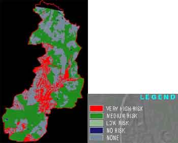
The optimal conditions set by the Ministry of Agriculture were used within the query builder module to create a locust habitat suitability map. In order to create the suitability map the following data layers were queried.
- Landuse/Landcover
- Soil Texture
- LandForm
- Vegetation Index
- Soil Texture
In the near future soil moisture values will be extracted and locust risk potential for each satellite overpass determined for the entire study area. The soil moisture extraction algorithm developed in this study will help to remove some of the dependence on point source data and the need for rainfall modeling procedures. Through the use of satellite data, particularly RADARSAT, spatial estimates of soil moisture can be obtained quickly and accurately. The model will be validated using data collected during 2002 and tested throughout additional locations in the upcoming year..AKNOWLEDGEMENTS The project was jointly funded by RADARSAT International and the Canadian International Development Agency (CIDA). A special note of appreciation is extended to the Space Research Institute of Kazakhstan who provided valuable soil moisture collection assistance during the summer fieldwork campaigns.