| GISdevelopment.net ---> AARS ---> ACRS 2002 ---> Hazard Mitigation and Disaster Management |
Deforestation in great
Aravalli Mountain Region of India
DR. Narpat Singh
Rathore
Associate Professor in Geography
College of Social Sciences & Humanities
M. L. Sukhadia
Udaipur - 313001 (Raj.) India
Fax : + 91 294 2415200
E-mail: mailto:rathorens%20@%20yahoo.com
Phone: +91 294 2426548 (R), +91 294 2414707 (O)
Associate Professor in Geography
College of Social Sciences & Humanities
M. L. Sukhadia
Udaipur - 313001 (Raj.) India
Fax : + 91 294 2415200
E-mail: mailto:rathorens%20@%20yahoo.com
Phone: +91 294 2426548 (R), +91 294 2414707 (O)
Abstract
This paper deals with deforestation, its causes and related environmental problems in the Great Aravalli Mountain region of north-west sector of the Indian sub-continent forming part of the state of Delhi, Haryana, Rajasthan and Gujarat. The deforestation trend from 1957 to 1998-2001 is assessed by means of Indian topographical sheets and satellite images. It is reported that the natural vegetation cover has decreased from 30% in 1982 to 15% in 1998-2001. This region was once famous for its greenery between Himalaya and Vindhyan mountain regions. A number of factors are involved in the deforestation. This study attempts to highlight the deforestation trend, and its associated causes and effects, so that this grave problem can be properly understood. It is also observed that the tribes of Great Aravalli followed unique type of tree mortgage system. Nearly 20 thousand year ago for the first time due to climatic changes the well civilised people of Great Aravalli migrated towards the north direction, which was inspired by migratory birds.
Introduction
Deforestation has become a matter of serious concern through out the developing countries of the world, which have large population to support. According to the Food and Agricultural Organisation (FAO, 2000), 35% of the world's forests have disappeared since 1950. It is claimed that nearly 30% of the total forest area in Bangladesh has been destroyed in the past 25 years. The forest cover in India decreased from 25% in 1970 to 30% in 1998. Deforestation is caused not only by development activities, but also by the new land reforms.
Study Area
The study area cover nearly 32550 km sq or 70% of the entire Great Aravalli mountain region of north-west India (Fig.1). This part of the Great Aravalli Mountain region constitutes 11% of the total geographical area of Delhi, Haryana, Rajasthan and Gujarat States. The entire forest area (70 %) of this region falls in the main Great Aravalli region, which is characterised by high hill ranges, valleys, plains, and plateau. The vegetation consists mainly moist deciduous, dry deciduous, montane, tropical thorn, mixed deciduous and dry teak species (Fig.1).
Data Source and Analysis
The principal source of data for this study are the Survey of Indian topographical sheets published on scales of 1: 63360 and 1: 253440, revised topographical sheets on 1: 50,000 and 1: 250,000 scale published in 1957, 1974 to 1976, Landsat images for 1975 at 1: 250,000 and 1982 on 1: 250,000. The colour composite satellite. IRS-WiFS, IRS ID LISS III data for year 1998-2001 on 1: 250,000 scale have been used. Forest areas are demarcated in all the topographical sheets of Great Aravalli Mountain region. The revised topographical sheets and satellite imagery have provided information on actual forest cover. The 1973 and 1982 Landsat images and 1998-2001 IRS WiFS satellite data have thoroughly scanned to delineate the natural vegetation. The maps resulting from the interpretation of the toposheets, Landsat and IRS WiFS data were reduced to a scale of 1: 10, 00,000 and superimposed; the final map (Figure 2) shows two zones: (1) The actual forest cover as in 1975; (ii) The depleted area, within the period of re-survey (1982), landsat 1975, 1982 and Indian satellite data IRS WIF 1998-2001. The validity of the information generated.by the above analysis was confirmed by a detailed field survey of a respective area covering about 15% of the total forest in the Great Aravalli mountain region.
Results
It can be seen that the area under forest cover in the Great Aravalli, Mountain region had been reduced to around 9% by 1975, although the official figure for area under forest was a little over 21%. It is evident that at the opening of 20th century, 80% of total geographical area of Great Aravalli mountain region was under natural vegetation cover. Between the first phases of the survey, i.e. within 20 to 22 years, the vegetation cover was reduced to about 40%. In other words, a depletion rate of around 30% is recorded for this period, indicating an annual rate of depletion of 1.5 sq.km. The latest data so far available from the IRS WiFS images for 1998-2001 suggest that the vegetative cover is, confined to around 7% of the total geographical area of Great Aravalli region. Hence, depletion in the second phase i.e. 1982 to 1998-2001, in a span of 15-17 years is a little over 15%. Comparing the actual vegetative cover (6116 sq km) under government control, it is observed that around 60% of legal forestland have been lost. Deforestation is caused by number of factors, and if the present trend continues, the obvious environmental problems will be multiplied, upsetting the entire economic structure and eco-system of the Great Aravalli mountain region. The causes and possible problems are discussed briefly in the following sections.
Causes of Deforestation
The process of deforestation just started after independence because of land reforms and the practice of shifting cultivation in south Aravalli areas. After independence, Rajasthan was formed in the year 1956 by the reorganisation of the princely states. Since then, the state experienced a great deal of development, in line with 5 years plans, so the decade of the 1960s heralded different development activities, such as irrigation projects, road construction, agricultural and residential expansion, population pressure etc. As a result, the clearance of forests became a normal practice for settlements, roads, agriculture, land allotment to landless people and other development work. The settlements have sprung up even in the heart of forest areas particularly in south Aravalli. Forest is no longer the province of the tribal people. Even people from the surrounding plains have migrated to the highly forested areas of Aravalli mountain region. To summarise, it can be said that deforestation is caused by a combination of numerous of factors. It is difficult to identify a single cause for it. The combined influence of economic pressure, population explosion, cattle population and government policies have together precipitated the present alarming situation.
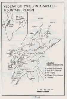
Figure 1.
Environmental Problems
Due to deforestation, a number of environmental problems occur; these have far reaching consequences. The adverse impact of deforestation on rainfall pattern is a controversial issue. In the Great Aravalli Mountain region, the decreasing levels of rainfall and rainy days is closely related to deforestation. The increasing rate of soil erosion due to deforestation is another well-established phenomenon. The Great Aravalli region is very prone to erosion under normal conditions, because of degraded oldest mountain of the world. While forest cover prevents topsoil from direct rainfall, wind and heat, its root system withholds the soil particles together. It is estimated that nearly 10,000 sq. km. of area is vulnerable to erosion and deforestation has aggravated the problem. Deforestation also affects the ground water conditions.
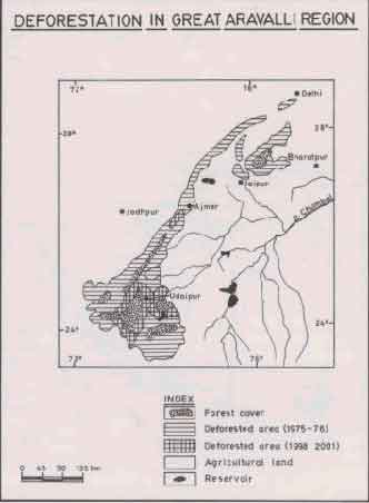
Figure 2.
Vegetation cover regulates the surface runoff by holding a certain amount of water in the soil particles around the root system; this water then gradually seeps down during the dry period. Once the forest is cleared, the entire process is hampered. Rock outcrops due to soil erosion occur frequently on the slopes and premature terraces have been formed by salutation reservoir. The Great Aravalli Mountain region has undergone slow deforestation because of the widespread felling of the trees due to biotic interference, mining, industrialisation, climatic changes and other direct or indirect factors. In the changes the degree of deforestation is very drastic in forest reserve areas on hilly region. Up to 1960s the Aravalli hills had dense forests and higher density of tree cover in the vast tracts of higher hills and deep valleys. However, massive felling of trees, caused by the greed of human beings and increasing demand for timber, fuel, fodder etc., has caused severe strain on the Eco-system.
Remedial Steps
Unfortunately, the Great Aravalli mountains one of the most degraded hill ranges of the country have not been considered fit for inclusion in the national programme for hill area development. A massive disorder in the availability of even the basic resources like fuel, fodder, timber and water has taken place. It is therefore, essential that a comprehensive strategy for the management and development of the environment and physical resources of the Aravalli is evolved and implemented without any further loss of time.
Proposals for hill area development programme
The Aravalli hill people generally lead forest based life support system. For the revival of the rich forest habitat in the barren areas, different afforestation schemes should be implemented on priority level. The Eco-forestry and pasture economy should be the corner stone of hill area development. Special mention may be made of a variety of horticultural development programmes, which may provide a great boost both to the individual and to the regional economies. For the development of forest areas in Aravalli hill tract the following programmes may be implemented (i) All measures should be taken for the protection, maintenance and management of the notified forest areas in the form of actual forests. (ii) All those areas where tribals and the hill people reside, should be provided with incentives to develop, maintain and manage their own forest farms and get returns for subsistence from their agro-forests (iii) The orchards, gardens and parks should be developed by involving the local people in and around the hill towns and tourist spots also. (iv) The plantation of trees in and around the individual residences and at the common places should also be encouraged to develop the green belts in the urban environs. (v) Besides the development and maintenance of notified forest areas by the forest department all other areas including the wastelands should be developed by the local people under afforestation programme in the hill areas under various schemes. If the people are convinced then these programme will be a success.
The Land of Oldest Civilisation: The mountain range of Great Aravallis has been the birthplace of the oldest civilisation of the world. During pre-historic period the tribals living were the most civilised than their counter parts elsewhere. Even today the life style, costume and, socio-economic structures of these people are far more advanced than the tribals living in any other parts of the world. These inhabitants knew the economic importance of the forests thousands of years ago. The finest example of this is that they treated the forest tree as a mode of exchange in the economic transaction. The main forest trees which were used as a mode of exchange in economic transaction and security were mango (Mangifera indica), Mahua (Madhuca indica), Tamarind (Tamarindus indica), Teak (Tectona grandis), Neem (Azadirachta), Anwala (Phyllanthus emblica), Babul (Acacia nilotica) Shisham (Daibergia sisso), Tendu (Diospyros cordifolia) etc.
But after independence as a result of land reforms this practice came to an end. Nomadic people like Pygmies of Central Africa, Semangs of South Thailand, Sakai or Sanoi of Malaysia, Kalahari Bushmen of South Africa, Eskimos of Tundra, Samoyeds, Tungu and Chaukchi of Siberia, Masaiy of East Africa, Badawins of Arabia, Kirghiz of Central Asia were not knowing the importance of tree likewise the aborigines of India including Nagas of Nagaland, Khasi of Meghalaya, Santhal of Jharkhand, Gond of Andhra Pradesh and Madhya Pradesh, Tharus & Bhotia of Uttaranchal, Kharias of Orissa,, Todas of South India and Gaddi of Himachal Pradesh were also not knowing the system of tree mortagage which was followed in the Great Arawali region. At present hundreds of trees are still available in the districts of Rajsamand, Udaipur, Sirohi, Dungarpur, Banswara and Chittorgarh in Rajasthan State, Jhabua district in Madhya-Pradesh and Banaskanta and Sabarkanta districts in the Gujarat State. The trees were given on mortgage by the tribal and other people of Aravalli mountain region to the wealthy people at the time of famine, drought and their needs and got the things of their requirements in return. This system was followed till independence. Even at the time of field checking in the southern Aravalli region it was found that there was a system of giving the trees in dowry particularly among the tribal people. The trees of Mango, Mahua, Tamarind, Teak, date palm, Neem, Anwala, Babul, Tendu etc. were given in dowry. It shows that in pre-historical period i.e. near about 20 thousand year ago the Aravalli primitive men were highly civilised, wiser and skilled. The ancient people of Aravalli were very advanced in the civilisation than the other tribes of the world.
The Land of Migration of Well Civilized Tribes: The biggest migration of the civilised tribal in the history of the world has taken place from the Great Aravalli mountain region only. In the first phase the migration took place in the northern direction. The northward migration of the civilised tribal people of Aravalli region was for the first time inspired by the migratory birds coming from the North from Siberia, Central Asia, Tibet and Himalayan region. On this basis it can be definitely said that the migration of well-civilised tribes took place from the Great Aravalli.Mountains particularly from the Mewar. Nearly 1600 years (480 A.D.) ago the last huge migration took place towards Nepal in the Himalayas. It is a co-incidence that the Kingship in Nepal is also the branch of the present ruler Maharana Shri Ji Aravind Singh Ji of Mewar in the Aravalli mountain region. The primary reasons for this migration were changes in the climatic conditions, fear of wildlife, increasing population, depleting natural resources, foreign invaders and also frequent occurrence of tectonic activity. Due to these reasons the well-developed civilised tribes of this region migrated towards the other parts of Asia. Nearly 20 thousand years ago for the first time due to climatic changes the well civilised people of Great Aravalli migrated towards the north direction, which was inspired by migratory birds. Later on the migration of people took place in the west, south and east direction. The well-developed civilised people of the Great Aravalli Mountain region migrated (Fig. 3) to the Persian Gulf, Zagros. Iran, Arab coastal region of the Mediterranean, Adriatic Sea and Balkan region in the west central Asia, Hindukush, Himalayas, Tibet and Mongolia in the northern direction, Myanmar, Thailand, Indonesia, Cambodia, Vietnam China and Korean Peninsula in the eastern direction and Deccan Plateau, Sri Lanka and other islands of Indian Ocean in the southern direction. Principally the native place of the Aryans was the Aravalli and near about 5 thousand years ago they came back and started living in Indus river basin. T he figure No. 3 shows the migration routes and direction from the Great Aravalli mountain region.
Conclusion
From the remotely sensed data showing actual forest cover on Aravalli Mountains and its surrounding area. It is apparent that a considerable area of forest has already been denuded. The environmental problems related to deforestation not only affect the ecology, but also threaten the agrarian economy. It is imperative that we take stock of this serious situation and amend our current forest management for the ultimate benefit of the society. Due to the Aravalli aforestation programme near about 2000 sq. km. of barren area has been converted into the greenery in Alwar, Jaipur, Ajmer, Rajsamand, Udaipur and Banswara districts. And last tip of the Great Aravalli Mountain region in north near Delhi. The data reveals that only 7% of area is under forest cover in 1998-2001 against the 33% which is stipulated in 1952 forest policy of India. The mountain range of Great Aravallis have been the birth place of the oldest civilisation of the world. The people of Aravalli were more advanced than the tribals living in any other parts of the world. These inhabitants knew the economic importance of the forest thousands of years ago. The finest example of this is that they treated the forest trees as a mode of exchange in the economic transaction during pre-historic period. Nearly 20 thousand years ago for the first time due to climatic changes the well civilised people of Great Aravalli migrated towards the north direction, which was inspired by migratory birds.
Acknowledgement
I am grateful to the Hon'ble Vice-Chancellor, Professor A.K. Singh for his kind permission and keen interest in completing this work. I am indebted to Dr. J. R. Sharma, Director, Regional Remote Sensing Service Centre, ISRO, Jodhpur for his guidance and encouragement. Active help rendered by Dr. L. S. Rao, Dr. Sharad Srivastava and Dr. K.N. Joshi for giving valuable comments and suggestions. Active help rendered by Mr. Narender Verma, research scholar in conducting the fieldwork and finalising the study is thankful. Thanks are also due to Mr. M. L. Ameta for cartographic work.
References
- Ambrose, P., 1969. Analytical human Geography. Langmans, Green and Co. Ltd.: Landon.
- Dicken, S.N. & Ditts, F.R., 1970. Introduction to Cultural Geography. Zerox College Publishing, Toronto Food and Agricultural organization (FAO).: 1981. Forest Resources of Tropical Asia. Rome, United Nations.
- Gautam, N.C. and Narayan, L.R.A., 1983: "Landsat MSS data for land cover inventory and mapping. A case study of Andhra Pradesh". Jour. Indi. Sec. Photo-Int. & Remote Sensing, Dehradun, India.
- National Remote Sensing Agency (NRSA), 1984: Forest Atlas of India - Rajasthan Forest Map, National Remote Sensing Agency, Hyderabad, A.P., India.
- Philbrick, A.K.: 1963. This human world, John Wiley & Sons. Inc. New York.
- Rathore, N.S., 1988: "Temporal Analysis of Forest Cover in the Siwana -Jalore Hilly Region: Through Remote Sensing Techniques. Transaction of India Society of Desert Technology. Vol. 1988. Jodhpur (Raj.), India.
- Rathore, N.S., 1992: "Application of Remote Sensing for Forest Cover Mapping of South Aravalli Ranges, Rajasthan and Gujarat. Remote Sensing Application and Geographic Information system, Recent Trends, ICORG-92, Hyderabad. Tata McGraw Hill Publishing Company Ltd., New Delhi.
- Rathore, N.S., 1993: "Application of Remote Sensing for Forest Cover Mapping of Central Aravalli Mountain Ranges in Rajasthan". Advances in Horticulture and Forestry, Vol. 3, 1993, Scientific Publishers, Jodhpur (Raj.), India.
- Rathore, N.S., 1995: "Temporal Analysis of Forest Cover in the Luni Basin Through Remote Sensing". Indian Desert Resources and Prespective at Development, Jaipur (Raj.), India.
- Sircar, D.C.,1960: Studies in the Geography of Ancient and Medieval India, Motilal Banarasi Das, New Delhi.
- Spencer, J.E. & Thomas. William L., 1954: Cultural Geography, Published by John Wiley &Sons, INC., Landon.
- Taylor, G., 1937: Environment, Race and Migration, Univ. of Toronto.
- Tod, James, 1971: Annals and Antiquities of Rajasthan (2 vols.). K.M.N. Publishers, New Delhi.
