| GISdevelopment.net ---> AARS ---> ACRS 2002 ---> Hazard Mitigation and Disaster Management |
GIS for disaster mitigation
and civil defence in TIROL/Austria
B.
Noggler
Daten-Verarbeitung-Tirol GmbH, A 6020 Innsbruck, Austria
Email: b.noggler@tirol.gv.at
M. Innerkofler
Federal Warning Center Tirol, Government of Tirol
A 6020 Innsbruck / Tirol
Email: m.innerkofler@tirol.gv.at
Daten-Verarbeitung-Tirol GmbH, A 6020 Innsbruck, Austria
Email: b.noggler@tirol.gv.at
M. Innerkofler
Federal Warning Center Tirol, Government of Tirol
A 6020 Innsbruck / Tirol
Email: m.innerkofler@tirol.gv.at
Abstract
Since 1999, GIS is integrated in many organisations of GO and NGOs in Tirol/Austria. The paper shows some aspects how to use GIS and how Web GIS applications are used local/large scale level and regional, small scale level (IKI).
GIS and disaster mitigation – 1999 to 2002
Thuesday, 23rd Februar 1999, 16:05: “….a big avalanche struck to Galtür. More than 60 people are missed….” This information from the district police headquarter was the start to one of the biggest rescue operation in Austria since many years.
Residents in Galtür managed are to dig out about 20 people, but 31 more were still buried as night fell. No outside help has reached Galtuer, because earlier avalanches had blocked the main road and bad weather prevented helicopters from flying in. 24 hours later, a second deadly avalanche smashed into Valzur – only a few kilometer near Galtür. Valzur was reached within a few hours by a specialist rescue team of around 150 people, and two people were rescued quickly, but 7 people died. A day later, on of the biggest air rescue operation was startet to evacuate nearly 20.000 people with 65 helicopter from 5 different nations, but to late for 37 people.
Saturday, 8:45 PM, an alarm at the regional warning center: “...abnormalincident in a nuclear power station close to the Austrian - Swiss border;radioactive discharge; due to the weather condition there is a chance that the radioactive cloud could pass Austria...”. In its dimension, those two events are totally different. The second event describes a state spanning incident, the first one “just” a local problem but this happened 1999.
But in both cases, there will be always the same question: “Where is the nuclear power station” or “Where is a proper helicopter landing spot”? A quick answer is possible if GIS is in work. Experience has shown that there are at least three basic assumptions necessary before GIS can be efficiently incorporated into operational disaster management (Noggler 2000a). The decision-makers in the operations centre must be fully aware of the possibilities offered by GIS, ensuring routine implementation when a disaster occurs.
Given the above knowledge, it must be possible for the operations centre personnel to see which information is available in which locality (e.g. tiris.gem database). The available digital data must be processed with the relevant algorithms, and be quickly accessible - well catered for using GIS on the Internet. The inclusion of digital data can then become commonplace when dealing with future disasters. Not only can the required specific information for a given disaster be made available rapidly and widely, it can also be updated frequently. The use of GIS maps on the Web has to be simple to use, clear and unequivocal - especially important given its use in high-stress situations (e.g. IKI and local GIS Web applications – tiris Geographic Services )..In fact there exist already lots of different geographic and non spatial information which i s easily and fast available for operational teams.
However those operational teams are often concentrating only on there specific task (e.g. dispatching systems for the red cross or the Mountain Rescue Team). More complete information about events as mentioned above are rare or in most cases even unavailable. That means that right now most GIS databases are confined to very specific information which is only accessible by different organisations. In case of a big emergency there is no chance to get all the information which would be needed for an efficient fast work. As disasters don’t keep those limits in most cases, a transborder and therefore transnational access to information resp. data is essential. Due to this facts IKI was developed. A password restricted area in the Internet will provide:
- specific information concerning disaster control to many topics (point 2)
- transprovincial- and transnational information (point 3)
- connection to specific local GIS Systems for detailed information (point 3)
The study of natural hazards enables access to all of the relevant, digitally available data in Tirol. The basic information is derived from the hazardous zone maps of the forestry services (for torrents, avalanches, mudslides and rock falls), and the flood-risk maps of the local river authority (Noggler 2000b). To ensure that these data are operationally not only quickly available, but also specific to a given situation, the information is grouped into three categories; avalanches, water and earth. A background aerial photo is loaded initially as background information. Further information is displayed depending on the chosen scale of the image. A digital disaster map may then be superimposed. This Web application is used within the local government of Tirol, communities, rescue organisations and many more. The application and all GIS data is provided by tiris, the governmental GIS

Figure 1: hazard zone map (avalanches in Galtür) with contour lines, address points, main roads (incl. kilometer postings) and arial picture (Web GIS application).
More Information: http://www.tirol.gv.at/tiris (german only).
Internet Information System for Disaster Control” – small scale
The above mentioned problems and gaps alone are reason enough to act. Cases in the past had shown, the necessity of such a GIS clearly. During the catastrophic snowfall in February 1999 (affected was Switzerland and Austria), the flood in Austria and Germany in the same year etc. data from neighbour states would have been needed urgently or would have radically assuaged the work with the involved aid organisations.
That was one reason why Austrian governmental GIS groups, Austrian federal warning centers and the avalanche warning centers held a workshop to the topic “GIS in civil defence and disaster control” in Tyrol in March 2001. During this two day workshop, it was clear, that everybody has to act very quickly. One result was to establish a “limitless” GIS Internet prototype called IKI for trans-national information exchange. IKI should be designed to show, how centralised and decentralised GIS data can be linked to one base application.
IKI itself, will contain only POI’s (Point of Interests) on national, regional and district level for objects like hospital, police, fire departments, road departments, airports, helicopter landing places, power stations, …. These point informations are combined with some important tabular information like telephone, community, URL and email. For background information IKI will use topographic maps and/or orthophotos (planned).
The second main information is a link from IKI to local GIS Web applications. Such applications exist already in many regional governments and aid or rescue organisations. This application can provide an operating unit with detailed (large scale) geographic information. E.g. hazardous zone maps (see 2) of the forestry services (for torrents, avalanches, mudslides and rock falls), and the flood-risk maps of the river authority are available in governmental GIS and are connected with IKI. The main important issue is, that IKI will just use this information, the GIS data itself will contain at the responsible organisation or governmental departments. This is very important, because only they will manage the database (e.g. adding new, updating existing data).
IKI will only be responsible to manage the POI’s and check the connection links to the local applications.
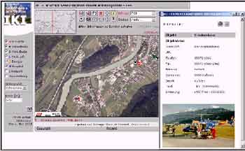
Figure 2: IKI – Web Application
IKI is running since spring 2002, about 2.500 POI’s from all Austrian provinces and the province of Bozen – Southtirol (Italy) are right now available. Inquiries from Germany (central office for civil.protection), Switzerland, Hungaria and Slovenia as well as first activities to gain other States through EC-Projects have been noted so far. The first EC project to finance IKI parts will start in January 2003 between Austria and Italy (InterregIII Austria/Tirol and Italy/South Tirol). If more of those efforts are successful, IKI could be advanced quickly. The Update of the existing POI’s as well as adding new points should be done through the internet. Therefore, a new application will be designed (IKI Digi) and should be available in autumn 2002. Naturally the presently product IKI (language german) will be translated in other languages with a main focus on English. More Information to IKI: http://tiris.tirol.gv.at/iki (english)
References:
- Noggler, B., Innerkofler M., Oberbichler M., 2002: Internet Katastrophenschutz Informationssystem (IKI). Angewandte Geographische Informationsverarbeitung XIV, S. 409-413.
- Noggler, B., 2000a: GIS im Katastrophen- und Zivilschutz (Neue Medien im Internet). Angewandte Geographische Informationsverarbeitung XII, S. 369-375.
- Noggler, B., 2000b: Internet GIS for disaster mitigation and civil defence in Tirol. In: Proceedings, Workshop on Advanced Techniques for the Assessment of Natural Hazards in Mountain Areas, June 2000, Innsbruck, Austria (SPA, Italy, University of Innsbruck, Fed. Ministry of Education, Science and Culture)