| GISdevelopment.net ---> AARS ---> ACRS 2002 ---> Earth Observation from Space |
FY-3 Series, The Second
Generation of Polar-Orbiting Meteorological Satellites of China
Wenjian Zhang
National Satellite Meteorological Center (NSMC)
China Meteorological Administration (CMA)
Beijing 100081, China
Wenjian Zhang
National Satellite Meteorological Center (NSMC)
China Meteorological Administration (CMA)
Beijing 100081, China
1. Preface
1.1 Introduction
China has launched four R&D meteorological satellites (including two polar orbiting and two geostationary R&D satellites) since 1988. That was FY-1A (polar) in 1988, FY-1B (polar) 1990, FY-2A (Geo.) in 1997 and FY-2B (Geo) in 2000, as well as the corresponding ground data acquisition, processing and application system, respectively. These R&D satellites and the ground segment are not only laid solid foundation for development of operational satellites and ground systems, but also provided valuable data, products and services to the whole country as well as the data coverage areas. Now the first operational meteorological satellite FY-1C (polar) was successfully operated in the orbit for almost three years, and her sister satellite, FY-1D, will be launched in the first half of 2002. In the same time, the FY-2 operational satellites FY-2C/D/E are under manufacturing and the first one FY-2C is schedules to be launched in late 2003.
The program of second generation of polar orbiting meteorological satellites, FY-3 series, with the beginning of the first two R&D satellites (FY-3A and FY-3B) formally started since 1999. Now the first two satellites and the onboard instruments are under manufacturing. This paper will give a brief introduction to FY-3 system, i.e., satellite system specifications, as well as the main payload.
1.2 The main objectives of developing FY-3 series.
The main mission objectives for FY-3 are:
- To provide global sounding of 3 -dimensional thermal and moisture structures of the atmosphere, cloud and precipitation parameters to support global and regional numerical weather prediction;
- To provide global imaging to support short range weather forecasting and real time monitoring of meteorological/hydrological disasters and surface environment anomaly
- To provide necessary data for deriving important geophysical parameters to support researches on global change and climate change.
- To collect and relay important data.
According to the current plan, there are two developing stages for FY-3 series, i.e. Research and Development (R&D) phase and operational phase.
In the R&D phase (2004-2008), i.e., most of the payloads are new developed instruments; two satellites (FY-3A and FY-3B) will be manufactured with limited sounding capabilities. The first satellite (FY-3A) and the instruments are now under manufacturing.
In the operational phase (after 2008), five satellites are planned with enhanced sounding and imaging capabilities on the basis of FY-3A & FY-3B.
2. FY-3A Satellite and Instrumentation
2.1 FY-3A satellite specifications and major orbital parameters FY-3A is a sun-synchronous polar-orbiting meteorological satellite. The satellite in general is a hexahedron of 4.4 2.0 2.0 meters and the configuration is depicted in figure 1.
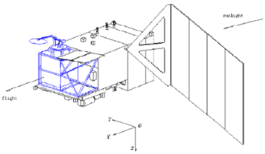
Figure 1. Configuration of FY-3A satellite
The total weight is estimated 2200 kg. The one solar panel is mounted on one side of the satellite main body which makes the total length of the satellite 10 meters in flight. The attitude control of the satellite is three-axis stabilized with a measuring precision of 50 meters with the aid of a star sensor onboard the satellite. Table 1 depicts the major orbital parameters of the satellite.
Table 1. FY-3A satellite specifications and major orbital parameters
| Weight | 2200 Kg |
| Orbit | Sun-synchronous |
| Altitude (km) | 836.4 |
| Power | 1100 Watts |
| Weight | 2200 Kg |
| Size | 4400*2000*2000 mm (in stowed) 4460*10000*3790 (in flight) |
| Orbital period (minutes) | 102.86 |
| Inclination (degrees) | 98.728 |
| Eccentricity | >0.005 |
| Equatorial crossing time | 10:10 (a.m.) |
| Orbital maintenances | 10 minutes within two years |
| Onboard data storage | 160 Gb |
| Attitude Control | Three-axis stabilization |
| Launch Vehicle | LM-4B |
| Launch Plan | September, 2005 |
2.2 Payloads onboard FY-3A
To achieve FY-3 objectives, a core meteorological payload with imaging and sounding mission instruments are designed and manufactured.
2.2.1 The Imaging Mission Payloads
There are 3 imagers for FY-3A mission, they are:
1) Visible and InfraRed Radiometer (VIRR)
This is a instrument heritage from Mulit-channel Visible and Infrared Scanning Radiometer (MVISR, 10 channels) onboard FY-1C/D satellites. Actually this 10-channel radiometer will make operational observations from FY3A. For risk reduction purpose, this instrument will remain the same as the MVISR during the FY-3A.
2) Moderate Resolution Visible and Infrared Imager (MODI).
Referring to MODIS onboard EOS satellite series, this instrument will have 20 channels for FY-3A satellite. The MODI channels will mainly located at VIS and NIR regional and the instrument VIRR will have the important IR channels. These two instruments are complement each other. The main characteristics of MODI is that there will be five channels (4 VIS and 1 thermal IR) with the 250 meters spatial resolution, which enables it image the earth with high resolution and near true color imagery during the day and get high resolution thermal IR image during the night. The channel wavelength characteristics are depicted in table 2.
Table 2. Major specifications of MODI
| Channel | Wavelength (ìm) | Band width (ìm) | Resolution (meter) | NEDñ () NEDT(300K) |
Dynamic range |
| 1 | 0.470 | 0.05 | 1000 | 0.1 | 100 |
| 2 | 0.550 | 0.05 | 250 | 0.2 | 100 |
| 3 | 0.650 | 0.05 | 250 | 0.3 | 100 |
| 4 | 0.865 | 0.05 | 250 | 0.3 | 100 |
| 5 | 1.640 | 0.05 | 250 | 0.1 | 90 |
| 6 | 2.130 | 0.05 | 1000 | 0.15 | 90 |
| 7 | 0.412 | 0.02 | 1000 | 0.1 | 80 |
| 8 | 0.443 | 0.02 | 1000 | 0.1 | 80 |
| 9 | 0.490 | 0.02 | 1000 | 0.05 | 80 |
| 10 | 0.520 | 0.02 | 1000 | 0.05 | 80 |
| 11 | 0.565 | 0.02 | 1000 | 0.05 | 80 |
| 12 | 0.650 | 0.02 | 1000 | 0.05 | 80 |
| 13 | 0.685 | 0.02 | 1000 | 0.05 | 80 |
| 14 | 0.765 | 0.02 | 1000 | 0.05 | 80 |
| 15 | 0.865 | 0.02 | 1000 | 0.05 | 80 |
| 16 | 0.905 | 0.02 | 1000 | 0.10 | 90 |
| 17 | 0.940 | 0.02 | 1000 | 0.10 | 90 |
| 18 | 0.980 | 0.02 | 1000 | 0.10 | 90 |
| 19 | 1.030 | 0.02 | 1000 | 0.10 | 90 |
| 20 | 11.50 | 2.0 | 250 | 0.3K | 330K |
In the FY-3 operational phase, this instrument will be merged with MODI into a imaging instrument suite.
3) Microwave Radiation Imager (MWRI)
This is aconical scanning microwave Imager at 6 frequency points with dual polarizations (12 channels). This sensor measures thermal microwave missions from land and ocean surfaces, and can measure various forms of waters in the atmosphere, clouds and surfaces. For microwave wavelengths are much longer in the electromagnetic spectrum compared with visible and infrared, and at some channels the wavelengths can be longer than one millimeter, then the imager can penetrates clouds, and provides forecasters with an all weather measurement capability. At higher frequency channels, such as 89 and 50 GHz, the scattering signature from the cloud and precipitation are also good indicators for detecting of rainfall over both land and ocean. The spatial resolutions are from 15 to 80 km, depending on the wavelengths. Table 3 shows the major specifications of the instrument.
Table 3. Major specifications of MWRI
| Frequency (GHz) | 10.65 | 18.7 | 23.8 | 36.5 | 89 | 150 |
| Polarization Bandwidth (MHz) |
H,V 180 |
H,V 200 |
H,V 400 |
H,V 1000 |
H,V 2000 |
H,V 2000 |
| Integral Time (ms) | 12 | 6 | 6 | 4 | 2 | 2 |
| Dynamic range (k) | 3-350 | 3-350 | 3-350 | 3-350 | 3-350 | 3-350 |
2.2.2 FY-3A Sounding Mission Payloads
1) Infrared Atmospheric Sounder (IRAS)
This is the primary sounder for FY-3A. It is a HIRS/3-like instrument (for channel information, please see NOAA-KLM user guide for details). However, there are 26 channels in total in this IR sounder. The first 20 channels are almost the same as HIRS/3, while the six more channels will enable IRAS having capacity of measuring aerosols, stratosphere temperature, carbon dioxide content and cirrus. The instrument optical FOV is 0.97 degrees, which makes the ground IFOV of 14 km at nadir (with nominal altitude of 900 km).
2) MicroWave atmospheric Temperature Sounder (MWTS)
This is a 8-channels passive scanning microwave sounder with the purpose of temperature sounding in cloudy region. There are four channels around 50 GHz and another four channels located at 19.35, 23.9, 31.0 and 89.0 GHz. Table 4 shows the major specifications of MWAS.
Table 4. Major specifications of MWTHS
| Ch. | Frequency (GHz) | Absorber | Band width (MHz) | NEDT (K) | Calibration Accuracy (K) |
Resolution (Nadir, km) |
| 1 | 19.35 | Window | 220 | 0.3 | 1.5 | 50 |
| 2 | 23.90 | H2O | 250 | 0.3 | 1.5 | 50 |
| 3 | 31.00 | Window | 600 | 0.25 | 1.5 | 50 |
| 4 | 50.31 | Window | 220 | 0.3 | 1.0 | 50 |
| 5 | 53.74 | O2 | 220 | 0.3 | 1.0 | 50 |
| 6 | 54.96 | O2 | 220 | 0.3 | 1.0 | 50 |
| 7 | 57.95 | O2 | 220 | 0.3 | 1.0 | 50 |
| 8 | 89.00 | Window | 6000 | 0.8 | 1.5 | 50 |
It is planned that the MWTS will be improved during FY-3B development and will be reach AMSU-A level for the FY-3 operational phase, mainly at:
(1) The temperature sounding channels will be increased to 10-12 channels, with combination of 4-5 window channels,
(2) With above improvements, the MWTS will be a primary sounder of FY-3 to carry on all-weather sounding.
3) Microwave atmospheric Humidity Sounder (MWHS)
With the recent progress, it is decided that the MWHS, similar to AMSU-B, could be onboard FY-3A satellite.
2.2.3 Ozone Mission
1) Total Ozone Mapper and Ozone Profiler (TOM/OP)
These two instruments are new sensors development for FY-3 for measurements of ozone in the earth’s atmosphere. TOM is mapped by a six-channel spectrometer with the wavelength from 308nm to 360 nm, with the resolution of 50 KM at the nadir. The profiler is a 12-channel spectrograph with the wavelength coverage of the spectrograph extending from 252 nm to 380 nm . The spatial resolution of OP is around 200 KM at Nadir.
2.2.4 The Earth Radiation Budget Unit (ERBU)
This instrument is very much like the ERBE instrument onboard NOAA satellite. There are wide-FOV and narrow-FOV observation units, separately, with two channels on each of the units. The broad-band channel covers the spectral range from 02. to 50 micrometers, and the narrow-band channel covers 0.2 to 3.5 micrometers, respectively. A separate solar constant monitoring instrument is included, consisting to and ERBU package.
2.2.5 Space Environment Monitoring Unit (SEMU)
Space Environment Monitor onboard FY-3 is the modified version of FY-1 Space Environment Monitoring instruments, with improved accuracy and measuring capacity for high-energy particles.
3. FY-3 data format and data transmission scheme.
The FY-3 interface formats are consistent with the requirement of the Consultative Committee for Space Data Systems (CCSDS) standards. However, further definition may be required to establish the physical layers of the data formats. This document is structured to identify FY-3 selected options and requirements. The spacecraft communications links are S-band and X-band. Commands are via S-band only. Command and Telemetry links may be active simultaneously. The S-band section of the Communications Subsystem provides primary telemetry and command (T&C) service to and from FY-3 ground stations. The X-band section of the Communication Subsystem provides the science and engineering data downlink for the FY-3 common spacecraft. Three modes of operation are provided:
- For the Delayed Picture Transmission (DPT) data format, which is actually in the direct playback (DP) mode, all the stored science and engineering data is transmitted in high data rate, at 110 Mbps, to the three NSMC national level ground playback stations (Beijing, Guangzhou and Urumuqi) when the satellite fly over within China territory. The transmission band frequency will be within 8025-8215 or 8215-8140 MHz, with bandwidth of 140 MHz. The data Modulation is QPSK;
- For the Mission Data Transmission date, which is the X-band Direct Broadcast (DB) mode, most of the real-time science and engineering data (except MODI data) is broadcast, at 20 Mbps, to any receiving station with line of sight view. The broadcasting band frequency is between 7750-7850 MHz, with the bandwidth of about 25 MHz;
- For the AHRPT data format, the data transmission band frequency is within 1698-1710 MHz, with band Width: 5.4 MHz. The Modulation is QPSK, with the data rate 4.2 Mbps. The data encoding is CONV(7, ¾), with global real time broadcasting. This data format will observe WMO AHRPT data format.
Table 5. FY-3 data types, onboard storage and broadcast/playback features
| MISSION | INSTRUMENTS | AHRPT | MPT | ONBOARD STORAGE | DPT |
| IMAGING MISSION | VIRR | 810min | |||
| MWRI | 810min | ||||
| MODI | 20min | ||||
| SOUNDING MISSION | IRAS | 810min | |||
| MWTS | 810min | ||||
| MWHS | 810min | ||||
| OZONE MISSION | TOM/OP | 810min | |||
| RADIATION MISSION | ERBU | 810min | |||
| SEMU | 810min | ||||
| TELEMETRY | TELEMETRY DATA | 810min |
4. Summary
Stepping into 21 st century, we are now in an era that space technology and application is undergoing a fast development. We are trying our best to make Chinese meteorological satellites one of the valuable components of space-based Global Observing System (GOS) of WMO. It is believed that the FY-3 satellites are not only benefit the nation of China, but also a big contribution to the international remote sensing community.
5. References
- FY-3 satellite general design plan, Shanghai Academy of Aerospace Technology, 2001.
- FY-3 ground segment preliminary general design, first edition, National Satellite Meteorological Center, August, 2001.