| GISdevelopment.net ---> AARS ---> ACRS 2002 ---> Earth Observation from Space |
Satellite Image Map of
Thailand
Siwarak Tuntaopas
Geo-Informatics Scientist, Geo-Informatics Center
Geo – Informatics and Space Technology Development Agency (Public Organization)
196 Phahonyothin Road, Chatuchak, Bangkok 10900, Thailand
Tel. 662-940-6420-9 ext.221 Fax.662-561-4830
E-mail : siwarak@gistda.or.th Thailand
Ramping Simking
Geo-Informatics Scientist, Geo-Informatics Center
Geo – Informatics and Space Technology Development Agency (Public Organization)
196 Phahonyothin Road, Chatuchak, Bangkok 10900, Thailand
Tel. 662-940-6420-9 ext.221 Fax.662-561-4830
Thailand
Abstract:
Presently, Geo-Informatics data, including satellite and geographic information system, are applied in several disciplines. Value-added data in different format have been produced to support user needs. Satellite image map is one of the products that aims to promote remote sensing and GIS applicati ons. User can select (paper or CD-ROM format) in both scales 1:50,000 and 1:250,000 and may be processed by using normal graphic software or image processing software. For urban are, the satellite image map in 1:25,000 scale is available.
To produce satellite image map, good quality satellite data have been selected. Processing procedure includes geometric correction, contrast stretching, mosaicing, filtering and area cutting. Band combination is made available both 345 in true color and 234 in false color. Panchromatic band may be combined instead of band 4 in some area case , depending on user ,requirements. The important geographic information like administration boundaries, position of office of Changwat and Amphoe, communication network, river, canal and drainage pattern, and others geographic name are compiled from 1:50,000 scale topographic map , which is overlaid on satellite image. Each mapsheet at 1:50,000 scale covers 27x27 sq. km. while 1:250,000 covers 108x160 sq. km. Selected satellite data have been collected from 1997-2002.
Introduction
Since 2000 Geo-Informatics and Space Technology Development Agency(Public Organization) , so called GISTDA , by the Geo-Informatics Database Section has launched the cooperative project with Royal Thai Survey Department (RTSD) . The project aims to provide Topographic Map at scales of 1:50,000 and 1:250,000 , including satellite image and spatial data. Consequently , the satellite image map has been produced by GISTDA. The following 3 purposes are considered :
- To produce geo-informatics database , which is the data collection , in time series acquired from LANDSAT-5, LANDSAT-7 and IRS . The Geometric Correction , then needed to be performed.
- To produce the spatial database that is nescessary for the map production based on topographic at the scale of 1:50,000 and the ground survey data
- To produce satellite image map for general purpose , to local and Internationnal Governmental Organizations , Private Sector , and NGOS.
The primary objective , is to produce satellite image map using remote sensing technology , and geographic information system (GIS) as a tool of tremendous potential to support users in all disciplines.
Methodology
Spatial data taken from the scanned 1:50,000 topographic map were digitized by using Microstation software. Next steps include scanning of topographic map for different Themes; geometrical rectification, vectorisation of thematic layers; and editing each layer to clean up some discontinuities and undesired features.Steps and procedures are summarized in Figure 1.
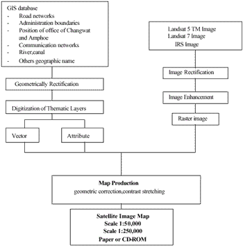
Figure 1 : Flow Chart for Satellite Image Map
Results
Today the satellite image map become very popular useful in many fields such as agriculture ,tourism ,traffic ,industry etc. Value added data is another way for the consumers. Satellite Image Map scales 1:50,000 and 1:250,000 data is helpful for genteral graphic map and special satellite image map.
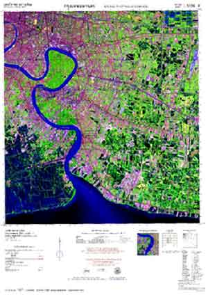
Satellite image map from LANDSAT TM data band 3 4 5 : B G R
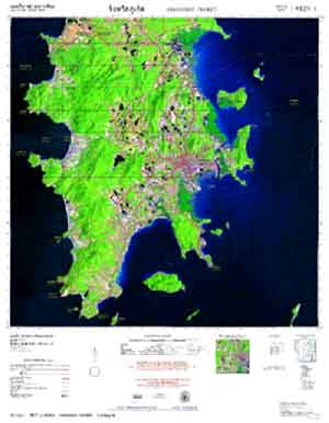
Satellite image map from LANDSAT 7 data band 3 4 5 : B G R
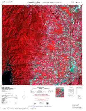
Satellite image map from IRS data band 2 3 4 : B G R
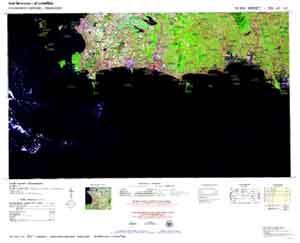
1:250,000 s cale Satellite image map from LANDSAT 7 data band 3 4 5 : B G R
Conclusion
Presently , satellite image map offers valuable information for many applications , such as agricultural applications , tourism management and planning , traffic network planning , industry management etc. Satellite image as Value-added data , is an alternative one that would be cost effective , up-to-date sources. Special requirements for digital format can also be made as that will be available at scales of 1:50,000 and 1:250,000 .