| GISdevelopment.net ---> AARS ---> ACRS 2002 ---> Ecology, Environment & Carbon Cycle |
Land Use of the Li-Speaking
People in a Mountainous Area of Hainan Island, China: Impact of National
Nature Reserve Established in 1986
Masahiro Umezaki
Section of International Health,
Graduate School of Tokyo Medical and Dental University
1-5-45 Yushima, Bunkyo, Tokyo 113-8519, Japan
Tel: (81)-3-5803-5188, Fax: (81)-3-3818-7176
Email: umezaki.ith@tmd.ac.jp
Japan
Krishna Pahari and Hong Wei Jiang
Department of Human Ecology,
School of International Health, University of Tokyo
7-3-1, Hongo, Bunkyo-ku, Tokyo 113-0033, Japan
Tel: (81)-3-5841-3608, Fax: (81)-3-5841-3395
Abstract
An IKONOS image for 2001 was used to produce a georeferenced map of land cover and land use for a Li-speaking village territory in mountainous areas of Hainan Island, China. The entire island of Hainan was established as a Special Economic Zone (SEZ) in 1988, when it became Hainan Province. Since then, it is one of most rapidly developing Provinces where large money has been invested to tourism development and cash cropping. The subject village is located on the foot of Mount Wushisan (the highest peak in the Island) where a national nature reserve was established and tourism development started in 1986. Indigenous subsistence of this village consisted of rice cultivation in the paddy fields, cultivation of rice and other crops in slush and burn fields, hunting animals, and gathering plants. Since the establishment of national reserve, however, subsistence activities that included burning, hunting, and gathering were placed under the ban. Instead, the government encouraged the people to plant cash crops (e.g. banana, tea, and medicinal plants) for increasing the income level of the villagers. Also, the grasslands around the villages that were maintained as sources of buffalo fodder and roofing materials have changed to secondary growth because regular burning was stopped. In the present paper, we investigated whether IKONOS could supply (1) a land use map of the village territory that will be useful for anthropological research and (2) a map that shows the distribution of slush and burn gardens or grassland before the establishment of the national reserve. For the latter purpose, the people's knowledge --secondary growth dominated with Haname lidacea trees were the grassland in the past-- were used. Also, we could find several indicator trees in the secondary growth that evidence the existence of slush and burn gardens in the past. Locations of such trees were recorded in the field so as to be used as training data for the classification. The results showed that the land use map made with IKONOS was sufficiently detailed and the past distribution of grassland could be identified, while identification of past slush and burn garden sites was not successful. High resolution satellite could provide useful information for anthropologists, though simplified analytical framework of satellite images should be presented for the utilization by non-professionals.
Introduction
For field scientists who study adaptation and survival of human beings, analysis of food production system is one indispensable research target. Particularly in these several decades, rapid population increase induced the degradation of food production systems in many regions and more attention has been paid to monitor the changing process (Umezaki et al., 2000). For instance, for the people who depend on rice cultivation, the land productivity and per capita area of paddy field are determinant factors of their food security or affluence. For the people who depend on shifting cultivation for their livelihood, location of the slush-and-burn gardens, area of potential gardens sites, and condition of secondary growth areas are the information needed for investigating their future sustainability of survival. The researchers, therefore, spending several months of their fieldwork period, measure the area of gardens (e.g., paddy field or slush-and-burn gardens), position them, and identify the owner of each, using tape measure, compass, and angle meter. In this sense, development of remote sensing has contributed a lot to the analysis of land use and land cover, and thus that of food production system, in the target populations (Brondizio et al, 1994; Conant, 1990).
Practically, Landsat TM (30m) or SPOT (20m) have been used for estimating the type of crops or size of gardens in large scale, mostly, in industrialized agricultural areas. However, they could not usually provide detailed information for the indigenous food production system in rural communities where small patches of gardens were made by a household, without clear definition of the boundaries. Slush-and-burn gardens with the length and width of 30m, for example, is equivalent to one pixel on the Landsat Image. IKONOS was launched in 2000, which has provided a satellite image of 4m resolution in multi spectrum data. It has been expected to be utilized for the land use analysis at a community level, though such application has been rare so far. The primary purpose of the present study is to investigate the ability of IKONOS for land use/land cover analysis in a small village where the authors have conducted anthropological field works for six months in total and have collected the field information as well as people’s recognition about the land use practices. The target village is located in Hainan Province of China.
Subject
The target village where the Li-speaking people inhabited is located in Wushisan city, Hainan Island of China. The entire Island of Hainan was established as a Special Economic Zone (SEZ) when it became a Hainan Province in 1988. Since then, it is one of most rapidly developing areas in China. Large money has been invested to tourism development and cash cropping. Along the process, the people's food production system or lifestyles have been changed.
The Li-speaking people are one of minority groups and have inhabited the mountainous parts of the Island. Their indigenous subsistence consists of rice cultivation in the paddy field, shifting cultivation of rice, maize, and tubers in slush-and-burn gardens, hunting wild animals and gathering wild plants. They reared large number of buffaloes primarily for plowing paddy fields and also as bride price or compensation in case of troubles. To maintain the fodder grasses for the buffaloes, the people had conducted regular burning in their neighboring mountains. As a result, natural forests diminished around the target village and the areas were covered with grasses or bare soil by 1980s. In 1980s, however, the Chinese government started to establish a policy to conserve or recover the natural environment of the Island. In 1986, the national reserve was established covering Mount Wushisan (the highest peak in Hainan Island) and the surrounding parts. Eastern parts of the target village lay in this reserved area were any burning or agricultural activities were put under the ban. In 1992, burning activities were prohibited even in the parts outside the national reserve.
Today, the past grasslands around the subject village are covered with secondary growth. The villagers claimed that grasslands have changed to secondary growth since 1986, because they stopped their burning activities. The shifting cultivation, hunting and gathering were also stopped. Instead, the government encouraged the people to plant cash crops (e.g. banana, tea, and medicinal plants) for increasing the income level of the villagers and the people did so.
The people claimed that the vegetation type of secondary growth differ by the type of former land use. On the sites that were used as grasslands for buffalo fodders and roofing materials, Haname lidacea will dominate the secondary growth (Fig 1, right). This is deciduous broad-leaved tree. It often stands collectively and the usually light-green leaves turn yellow or red in December to January. The leaves will fall before long. New leaves bud in February to March. The IKONOS data used in this study was taken on 24 March 2001 when Haname lidacea trees had vivid light-green leaves. This can work as an advantage for the classification process. On the other hand, on the sites that were used as slush-and-burn gardens in the past, two species of trees (Alchornea liukiuensis Hayata, and, Mallotus japonicus) can be found (Fig 1, left). Though these trees do not stand collectively, the color of leaves is brighter than those of trees in matured forest and is different from that of Haname lidacea trees. The people could identify, on the basis of type of vegetation in the secondary grouth, whether the site was grassland for buffaloes fodders or slush-and-burn gardens. This folk knowledge for the secondary growth was used in the present study to estimate the spatial distribution of grassland and slush and burn gardens before the national reserve was established in 1986.
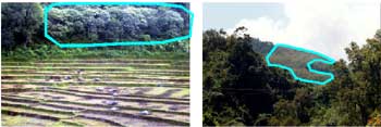
Fig. 1 Alchornea liukiuensis Hayata , the index trees of past slush-and-burn garden sites (left); collective stands of Haname lidacea, the index trees of past grasslands (right).
Methods
Fieldwork was conducted in September to November 2000, July to September 2001, March 2002, and June 2002. Ground control points were collected using two GPS equipments (Trimble, GeoExplorer III) that enabled us to apply differential correction using Pathfinder Office software (Trimble). The IKONOS image on 24 March 2001 was corrected geometrically with these ground control points.
The land use category that are useful for our anthropological research were first established and training data were collected for each category (Table 1). Since this categorization was made just for anthropological purpose, several land use categories were not definitely different in spectrum pattern, probably falling into one land cover category. For example, there defined four types of grassland according to the Li-speaking people’s categorization (i.e., grassland on mountain ridge, patches of grasslands on the mountain slopes, grassland in the abandoned paddy fields, grasslands on very steep slopes), but all of them are covered by grasses and it was unknown whether IKONOS could identify the minor difference in grasses types and their spectrum patterns. Supervised classification with maximum likelihood rule was applied for the classification.
Table 1. Land use category applied to the target village in Hainan Province of China; Number of training data polygons and results of supervised classification are also shown
| Land use category | Number of training data polygons | Results of supervised classification |
| (%) | ||
| Grasses and trees | ||
| Paddy fields | 10 | 4.1 |
| Banana gardens | 9 | 13.9 |
| Gardens (just planted) | 2 | 0.4 |
| Paddy fields in the past | 4 | 0.8 |
| Grassland on the ridge | 3 | 0.7 |
| Grassland on the slope | 5 | 7.3 |
| Sugar cane | 2 | 0.2 |
| Riverside (including gardens) | 4 | 1 |
| Secondary growth in slope garden sites | 1 | 2.1 |
| Secondary growth in grasslands | 10 | 23.8 |
| Matured forest | 8 | 31.5 |
| Cedar Trees (for cash) | 4 | 4.8 |
| Others | ||
| Pond | 3 | 0.4 |
| River | 4 | |
| Road (not paved) | 7 | 1.4 |
| Road (paved) | 2 | |
| Roof of houses | 6 | |
| Rock | 1 | 0.2 |
| Shadow_1 | 6 | 7.5 |
Results and Discussion
Figure 2 shows the classified IKONOS image around the neighboring places of Mount Wushisan and the target village. Yellow parts show the location of paddy fields under use. The target village located at the site indicated with "A". Their four major paddy fields are clearly displayed around the village site. A road toward the northwest will go to the county station. Matured forest (dark green) extends from the Mount Wushisan (north-east of the image) to the south and then to the west. The secondary growth of Haname lidacea trees, which is supposed to be past grasslands for buffaloes fodder and roofing materials, are indicated with red color. This part is almost identical with the national reserve area established in 1986. The positive effect of reserve establishment to encourage the secondary growth is obvious with this result. Secondary growth of Alchornea liukiuensis Hayata trees, which is supposed to be slush-and-burn garden sites in the past, could not be classified successfully probably because the training data were insufficient and the size of gardens were too small for this analysis. To the east of the village, just under the ridge (blue and light green, indicated with "B"), patches of grassland on steep slopes were found. The villagers explained that the sites are too steep that the grasslands have been maintained even after the burning activities were put under the ban. Light green parts to the north east of the target village are mostly banana gardens that have been encouraged to make by the government so as to increase the income level of the households. Two light blue patches between "A" and "B" are the paddy fields abandoned in 1950s.
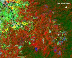
Table 1 shows the quantitative figures of the classified images. Of the total image, 24% were classified as "secondary growth in grasslands", while only 2% as "secondary growth in slope garden sites". The former category is supposed to have been maintained by regular burning activity before the establishment of national reserve in 1986, while the latter corresponds to the slush-and-burn garden sites in the past. After this classification, we brought the classified image to the target village and asked the people whether each site, categorized as "secondary growth in grasslands" or "secondary growth in slope gardens", were really grasslands maintained by burning or slush-and-burn gardens in the past, respectively. The people generally agreed with the identification of former sites. For the latter category, however, the categorization did not accord with the people's memory. From the viewpoint of plant ecology, the existence of index plants will tell us "probably there were shifting gardens", but not "when the sites were used as gardens", because we do not know the pattern of vegetation succession in this micro-environment. Further studies are required in this point.
Conclusion and Further Analyses
Further work is undertaken to analyze the land use practices of the people by relating with the topographic data, distance from roads and other variables (cf. krishna et al, 2002), which will be presented in the conference. Although the analysis presented in this paper is still preliminary, the potential ability of IKONOS for anthropological research was suggested. For anthropologists who usually study small patches of gardens or paddy fields, IKONOS is the first satellite that will provide sufficient information to their research. However, the previous classification procedures have been developed on the basis of Landsat or similar resolution satellites, and thus they could not necessarily be apply to IKONOS image in their present form. Further development of classification technologies, that consider the texture pattern of the surface for example (e.g., Suzaki and Shibasaki, 1998), and its simple presentation is necessary for the non-specialists of remote sensing to utilize the high-resolution satellite data for their research.
Acknowledgement
This study was financially supported from Japan Society for the Promotion of Science (Research for the Future Program, project leader: Professor Ryutaro Ohtsuka) and partly the Japanese ministry of Education, Science, Sports, and Culture.
References
- Brondizio, ES, Moran, EF, Mausel, P, Wu, Y, 1994. Land use change in the Amazon Estuary: Patterns of Coboclo settlement and landscape management. Human Ecology, 22 (3), pp. 249-278.
- Conant, FP, 1990. 1990 and beyond: satellite remote sensing and ecological anthropology. In: The Ecosystem Approach in Anthropology: From COncept to Practice, edited by Moran, EF, The University of Michigan Press, Ann Arbor, pp. 357-388.
- Krishna, P, Umezaki, M, Jiang, HW, 2002. A study of land use and environment in Tonza city area in Hainan Province, China: twenty years of change. Proceedings of 22nd Asian Conference on Remote Sensing, Kathmandu.
- Suzaki, J, Shibasaki, R, 1998. Cropfield extraction method using NDVI and texture for Landsat TM images. Journal of the Japan Society of Photogrammetry and Remote Sensing, 37 (5), pp. 54-62.
- Umezaki, M, Kuchikura, Y, Yamauchi, T, and Ohtsuka, R, 2000. Impact of population pressure on food production: an analysis of land use change and subsistence pattern in the Tari basin in Papua New Guinea Highlands. Human Ecology, 28 (3), pp. 359-381.