| GISdevelopment.net ---> AARS ---> ACRS 2002 ---> Data Processing, Algorithm and Modelling |
An auto-multivariate model of
muntjacs habitat use for a geographic information system in southern
Taiwan
Lai, Yu
-Ching
Assistant Professor, Department of Environmental Design
Huafan University
1 Huafan Road, Shihting, Taipei County
China Taipei, R. O. C.
E-mail: yuching@huafan.hfu.edu.tw
Kurtis Jai-Chyi Pei
Associate Professor, Institute of Wildlife Conservation
National Pingtung University of Science and Technology
Neipu, Pingtung, China Taipei, R. O. C.
E-mail: kcjpei@mail.npust.edu.tw
Po-Jen Chiang
Institute of Wildlife Conservation
National Pingtung University of Science and Technology
Neipu, Pingtung, China Taipei, R. O. C.
Hsu Li-Ta
Associate Professor, Department of Forestry
Chinese Culture University
55 Hwa-Kang Rd. Taipei 111, China Taipei ROC.
Email: lita@faculty.pccu.edu.tw
Abstract
The ability to model habitat use, habitat use potential, and change in distribution of habitat is of considerable importance in wildlife management as to predict patterns of biological diversity or identifying geographical areas of conservation significance. In this study, we developed an auto-multivariate method to model habitat- use potential using a set of Muntjac recording locations and habitat data consisting of variables such as elevation, aspect, slope, whole light sky space, forest cover type, forest cover type diversity, distance to river, and distance to road in the mountain area of southern Taiwan. The model is based on the multivariate regression statistic coupled with Geographic Information System (GIS) technology to incorporate spatial correlation of wildlife -habitat relationship. Muntjac abundance obtained from auto-triggered cameras and habitat variables were used to explain habitat selection and to identify areas of high use potential of Muntjac in natural forest of southern Taiwan. Calculations were made with the GIS to generate spatial habitat variables and to produce a map containing habitat use potential that could not otherwise be identified by independent perusal of any single map layer. Confirmation of the accuracy of predictions of Muntjac.distribution in Southern Taiwan was assessed with both survey data and expert’s evaluation. Results shown th at this technique is a useful tool for habitat manipulation or mitigation to favor terrestrial vertebrates that use habitats on a landscape scale.
Introduction
Chinese or Reeves’ Muntjac (Muntiacus reevesi) are native to China and Taiwan (Sheng 1992, McCullough 1974). It is one of the small ungulates that occur in temperate to tropical forests (McCullough et al. 2000). It is of interest because of their conservation and ungulate lineage importance. Research shows that it is predominantly forest dwelling and appear to be concentrate selectors of habitat (Hofmann 1985). However, little is known about Reeves’ Muntjac in their native habitats because of the difficulties in long-term observation and trace in the wild (McCullough et al. 2000). Effective management of wildlife population largely depends upon understand and predicting their habitat needs (Buckland and Elston 1993). Use of multivariate statistics and Geographic Information System (GIS) to assess habitat suitability has increased in recent years because the spatial characteristics and multi-dimensional nature of habitat limits use of simple univariate statistical techniques (Howell et al. 2000, Brito et al. 1999, Gros and Rejmanek 1999, McKenney et al. 1998, Buckland et al. 1996, Clark et al. 1993).
However, i n regression analysis spatial autocorrelation of the information is sometimes ignores yet it has the effect of reducing the power of the model since observations are influenced by neighboring areas that tend to have similar conditions (Anselin 1993, Augustin et al. 1996). In this study, Reeves’ Muntjac abundance obtained from auto-triggered cameras and habitat variables obtained from digital terrain model (DTM) were used to explain habitat selection and to identify areas of high use potential of Muntjac in natural forest of southern Taiwan. Spatial autocorrelations is modeled explicitly by extending the result logistic model to include an extra covariate that is derived from the responses at neighboring squares (Augustin et al. 1996).
Methodology
The study area located at the mountain area of southern Taiwan including Shuang -Kuel-Hu Nature Reserve, North Ta-Wu Nature Reserve, and Ta-Wu-Shan Nature Reserve (Fig. 1). Collectively, the 3 reserves consist of more than 234,000 acres of secondary hardwood forest. Primary vegetation includes species such as Cyclobalanopsis morii, Adiandra lasiostyla, Cyclobalanopsis longinus, Persea japonica, Tsuga chinensis, Chamaecyparis formosana, Castanopsis carlesii, Alnus formosana, and Acer kawakamii. A total of 103 study sites were randomly allocated in the study area to conduct survey from 1992 to 2001 (Fig. 1). Each auto-trigger camera was installed 1.5 to 2.5 meters above ground and their locations were recorded using GPS receiver. Depending on the a bundance of the carnivores and availability of study site, film and battery was collected and replaced every 2 to 4 weeks. Relative abundance for Reeves’ Muntjac was generated from the field survey. The relative abundance for Muntjac was represented by the Occurrence Index (OI = the number of pictures taken per 1,000 camera working hour) (Pei 1998, Pei et al. 1997). Serial pictures belong to the same individual taken during a short.period (usually within 30 minutes) will be considered only 1 picture in the calculation to prevent the over-representative of a lingering individual, hence, to reduce thepossibility of over-estimation of the abundance. Camera working hours for each roll of film was the time span between the starting time of a new roll of filmand the time recorded on the last picture in the case of the film was finished before the next checking by the researchers, or the time when the researchers arrived for collecting the film, in the case of the film was not finished. There were total of 8 explanatory variables used to model Muntjac distribution. The geographical variables, i.e. elevation, slope, and aspect, were measured at study site. The landscape statistics, i.e. distance to river, distance to major road, land-use, land-use diversity, and whole light sky space, werecalculated with 40 meter resolution using GIS database and an existing Digital Terrain Model (DTM) and land use map. Using GIS, the number of different cover types within an 9*9 matrix of 40 -m cells (12.9ha) surrounding the center cell was assigned to that center cell to obtain a measure of cover-type diversity. This matrix size corresponded to a core habitat area of male Muntjac(Chapman et al. 1994, McCullough et al. 2000). Whole-light-sky-space indicates the potential sunlight radiation denoted by percentage of open sky. Its value was calculated from DTM data and algorithm written in C language (Cheng et al. 2002). A layer of moist regimes was generated from Mesic to Xeric throughreclassification of aspect map according to Whittaker (1986).
Multivariate analyses were used to develop wildlife- habitat relationships. All variables were then tested for normality and correlation. The Pearson Correlation Coefficient matrix was generated to test the correlation of covariates. A stepwise multiple regression models was used to determine which of the 8 landscape variables accounted for the greatest amount of variation in Muntjacs abundance (OI value). K-S goodness-of- fit test and stepwise elimination process with P<0.05 was per formed to understand habitat use by Muntjac by individual map layers (forest type, elevation, slope, aspect, and diversity). The multivariate model was expanded to generate Reeves’ Muntjac distribution map of the whole study area. Adding the term for autocorrelation, Ai, leads to the auto-multivariate model
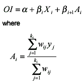
is a weighted average of the number of occupied squares amongst a set of ki neighbors of squarei. The weight given to square j, wij, is the reversed Euclidean distance between squares i and j. The same male core range, i.e.12.9ha was used for the clique size in the study. The auto -multivariate model was fit to every pixel of expanded distribution map. Model accuracy was examined by comparing study site observations with model predictions.
Result and Discussion
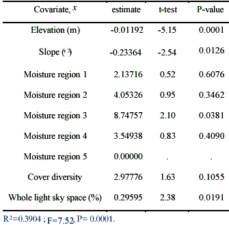
Among the 103 camera sites, 80 sites have recorded Muntjac activities, which include about 77.67% of total study sites. Muntjacs were absent from other 23 camera sites. With all covariates and their transformations, 5 variables were selected for the multiple regression model with R 2 =0.39. They were elevation, slope, moist regime, land use diversity, and whole-light-sky-space was selected for the model. For th e 103 camera sites, frequencies of elevation and slope were equally distributed between the rages of 400 meter to 2,900 meter and 0 to 50 degrees, respectively. Whole light sky space ranges from 32% to 82%, however, extreme poor or abundant of sunlight radiation potential were less. Aspect was classified into moisture regime in a descending manner with class 1 as mesic and class 5 xeric. Land use diversity showed most camera sites were located in continuous land use patches instead of fragmented land use patch. Pearson correlation coefficient showed all continuous variables were independent to each other, which indicated the selection of each variable did not affect the contributions of other variables. The multivariate regression equations obtained for the study area showed that Muntjacs were more abundant in lower elevation, flatter slope, with higher land use diversity and medium WLS. Subxeric to submesic appears to be most suitable moisture class to Muntjacs (Table 1).
The stepwise multiple regression model was applied to the whole landscape with existing DTM data and GIS technology (Figure1 ). The estimated Muntjac distribution showed a relatively higher Muntjac abundance in lower elevation and flatter slope area. In higher elevation, the Munjac abundance was usually lower except for area of more Mesic environment.
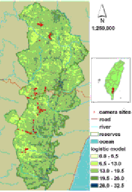
Figure 1. Estimated Reeves’ Muntjac distribution and camera sites in Shuang-Kuel-Hu Nature Reserve, North Ta-Wu Nature Reserve, and Ta-Wu-Shan Nature Reserve in Taiwan
The simple matching coefficient showed that the predicted and observed values agreed for 78% ((75+5)/103=0.78) in the model (Table 2).
Table 2. Matching counts of logistic model : a method to assess the matching of predicted sample and observed sample
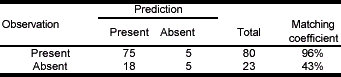
Simple matching coefficient = (75+5)/103=0.78
However, since the logistic predicts the OI values which gives the distribution of suitability of habitat instead of the absent/present of Muntjac, if the distance to observed OI value was to be used, the matching coefficient increased to 85% (Table 3).
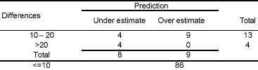
Simple matching coefficient=86/103=0.84
*: 5 samples were matched exactly
Overall, the auto-multivariate model of Reeves’ Muntjac agrees with field survey and field experience, therefore, provides good estimation of distribution. In this study, landscape variables are proofed to be useful explanatory variable for Muntjac distribution model. Part of the reason for the high prediction rate of using landscape variables only may because of Muntjac is a more common species that is not very selective for their habitat. If habitat use of other species were to be assessed, other explanatory variables such as vegetation species and vegetation structure may have to be included.
Literature Cited
- Anselin, L. 1993. Discrete space autoregressive models. – In: Goodchild, M.R., B.O. Parks and L.T. Steyaert (eds) Environmental modeling with GIS. Oxford Univ. Press. Pp.454-469.
- Augustin, N.H., M.A. Mugglestone, and S.T. Buckland. 1996. An autologistic model for the spatial distribution of wildlife. J. of Applied Ecology 33:339-347.
- Brito, J.C., E.G. Crespo, and O.S. Paulo. 1999. Modelling wildlife distributions: logistic multiple regression vs overlap analysis. Ecography 22:251-260.
- Buckland, S.T. and D.A. Elston. 1993. Empirical models for the spatial distribution of wildlife. J. of Applied Ecology 30:478-495.
- Buckland, S.T. D.A. Elston, and S.J. Beaney. 1996. Predicting distributional change, with application to bird distributions in northeast Scotland. Global Ecology and Biogeography Letters 5:66-84. Chapman, N., S. Harris, and A. Stanford. 1994. Reeves ’ Muntjac Muntiacus reevesi in Britain: their history, spread, habitat selection, and the role of human intervention in accelerating their dispersal. Mammal Rev. 24(3): 113-160.
- Cheng, C. C., C. C. Chang, C. K. Liu. 2002. Application of geographic information system of vegetation distribution for the LiuKuei ecosystem management area. Taiwan J For Sci 17(2):195-203.
- Clark, J. D., J.E. Dunn, and K.G. Smith. 1993. A multivariate model of female black bear habitat use for a Geographic Information System. J. Wildlife Management: 57(3): 519-526.
- Gros, P.M. and M. Rejmanek. 1999. Status and habitat preferences of Uganda cheetahs: an attempt to predict carnivore occurrence based on vegetation structure. Biodiversity and Conservation 8: 1561-1583.
- Hofmann, R.R. 1985. Digestive physiology of the deer-their morphophysiological specialization and adaptation. Bull. R. Soc. N.Z. No. 22:393-407.
- McCullough, D.R. 1974. Status of larger mammals in Taiwan. Taiwan Tourism Bureau, Ta ipei, Taiwan, Republic of China.
- McCullough, Dale R., Kurtis C.J. Pei, and Y. Wang. 2000. Home range, activity patterns, and habitat relations of Reeves’ muntjacs in Taiwan. J. of wildlife managemeng 64(2):430-441.?McKenney D.W., R.S. Rempel, L.A. Venier, Y. Wang, and A.R. Bisset. 1998. Development and application of a spatially explicit moose population model. Can. J. Zool. 76: 1922-1931.
- Howell, C.A., S.C. Latta, T.M. Donovan, P.A. Porneluzi, G.R. Parks, and J. Faaborg. 2000. Landscape effects mediate breeding bird abundance in Midwestern forests. Landscape Ecology 15:547-562.
- Pei, K. 1998. An evaluation of using auto-trigger cameras to record activity patterns of wild animals. Taiwan J. For. Sci. 13(4): 317-324.
- Pei, K., Chen, C. T., Wu, S. T. and Teng, M. C. 1997. Use of auto-trigger camera and Geographic Information System to study spatial distribution of forest wildlife. Q. Jour. Chin. For. 30(3): 279-289.
- Whittaker, R. H. 1960. Vegetation of the Siskiyou mountains, Oregon and California. Ecological Monographs 30(3):279-338.
- Sheng, H. 1992. The deer in China. East China Normal Unibersity Press, Shanghai, People’s Republic of China.