| GISdevelopment.net ---> AARS ---> ACRS 2002 ---> Data Processing, Algorithm and Modelling |
A study of management system
of the ground control point database for ROCSAT-2 Remote Sensing
images
Chih-Li
Chang
National Space Program Office
8F, 9 Prosperity 1st Road, Science-based Industrial Park
Hsinchu, 300, China Taipei
Tel: +886-3-5784208 ext. 8461
Fax: +886-3-5799972
E-mail: CLChang@nspo.gov.tw
Ta-Ko Chen
Researcher , Remote Sensing Dept.
Energy & Resource Laboratories ,ITRI
Bldg. 24, 195-6 Sec. 4, Chung Hsing Rd.
Chutung Hsinchu, China Taipei 310
Tel:+886-3-5914332
Fax:+886-3-5820038
E-mail: Tkchen@itri.org.tw
Abstract
To precisely correct geometric distortion of ROCSAT - 2 remote sensing images, a database of ground control points (GCPs) is urgently needed for China Taipei area. A known algorithm of geometric correction was introduced first. And a distribution of GCPs of China Taipei area was proposed. The distribution of GCPs is to make sure that any scene of China Taipei will be allocated enough GCPs for the data processing. Then, the attributes of a GCP are defined and the functions of a management database system are described, accordingly. Finally, three GCPs were selected as test samples. They are located in the north, middle and south of China Taipei, respectively. They represent for the city, country and mountain areas, respectively. The attributes of the three selected GCPs were collected on ground. The north testing GCP in the database management system was demonstrated in the study.
Introduction
The ROCSAT- 2 program was initiated in 1997. Mission of the ROCSAT -2 program was defined as below.
“ROCSAT - 2 mission objectives include civil applications to natural disaster evaluation, agriculture and forestry, land use, environmental monitoring, coast search and rescue, academic researches and education, and international cooperation.” (Wang, 2000)
An investigation on the requirements and applications of remote sensing was conducted at the beginning (Chang 2002a). Two kinds of studies for ROCSAT-2 program have been carried out. First, the image processing technique has been studied. To estimate rice production, canopy reflectance spectrum was measured in the test field. The yield data were recorded. The correlation between yield and spectral reflectance was studied. The DEM can be derived from a stereo pair of simulated ROCSAT -2 images. The ROCSAT - 2 images were simulated from higher resolution sources. The sources are from air and space images. The identification of rice field has been studied extensively in China Taipei. In practice, the raw data with cloud cover less than 10% is required to be processed into product for an optical remote sensing image. More frequently visiting the same target will be more chance to get good quality of images. Since ROCSAT-2 is the only daily revisit remote sensing satellite so that it will provide the most images among optical imaging satellites for the agriculture applications in China Taipei. Second, ground truths data were collected. Spectral reflectance of the mainly land cover/use was.measured with hand- held spectrometer. (Chang 2002b) The simulated ROCSAT -2 spectral reflectance was derived from the ground measurement. At the same time, the locations of ground control points were surveyed for precisely geometrical correction in China Taipei.
Ground Control Points
To correct radiometric and geometrical distortion for a level-1b product, the prior known parameters are applied for data processing. The ROCSAT- 2 satellite has the very good pointing capability with the stable attitude determination and control system. However, The GCP is needed as the ground reference to precisely correct the location accuracy of the image.
A location model was built for level- 1b processing (CNES 1997). The location model is a pair of quadratic equations to present the relation between the number of pixel and the coordination of the target point. Two models such as direct and inverse models are specified with twelve coefficients.
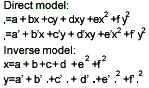
where:
x and y are the line and column number of the pixel
and are the latitude and longitude of the target point
To reduce the number of the coefficients, a simplified model is specified with fewer coefficients, for example, eight coefficients. For eight-coefficient model, the coefficients of e, f, e’ and f’ are neglected. If the models are applied to precisely geometrical correction with GCPs, four to six points are required to calculate the coefficients of the models. To design the distribution of GCPs for China Taipei area, some assumptions of distribution for the GCPs are as follows.
- A typical ROCSAT-2 image scene with size of 24 km x 24 km
- At least four GCPs in a ROCSAT-2 image scene
- Start line of a scene ahead of a grid line for 1 km
- GCP around the corner of the grid within a radius of 1 km
Database Management System
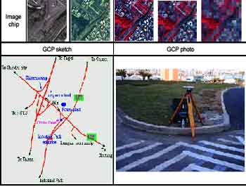
To describe a GCP, two types of attributes are required, such as space and image attributes (Lee 1998). For space attributes, they are source, built date, name of point, number, level, geographical coordinate, location, map reference, code, and description. For image attributes, they are sketch, photo, and image chip. The attributes are summarized as table in Table 1 and 2. The typical examples of attributes are as Table 3 for codes, as Figure 1(a) for sketch, as Figure 1(b) for photo, as Figure 1(c) for image chip. All attributes of GCPs are managed by a database system, for example Sybase, or Excel. The database system shall provide functions of edit, I/O, display and query to manipulate the attribute. Those functions can be programmed with some tool, like MicroSoft Visual Studio or Java.
Query is very useful function for the system. The query conditions can be any space attribute. The user can also inquire interactively from a map on the CRT, such as Figure 2, with sub - functions of enlarge, reduce, and shift. The area of query can be a point or rectangular area. The results of the query are displayed on the CRT. Space attributes of a GCP are displayed as Figure 3. Further query of image attributes is initiated at the bottom of the display. For example, one of the three.buttons, the sketch button, at the right of the bottom s is pushed, the drawing of the sketch will be popped out as Figure 4.
| Attributes | Summarization |
| Name | To name the GCPs according to location and characteristic. |
| Number | To set up a serious number to each GCP |
| Level | To designate the GCP Level according to the accuracy of GCP geometric coordinates . |
| Coordinate | To record the GCP's space coordinates that including TWD67 and WGS84 coordinate systems. |
| Built time | To record the GCP built time. |
| Source | To record the survey method of GCP coordinates . ( GPS survey, Digitizing from map …) |
| Location | To record the county where the GCP located . |
| Map reference | To record the map number (1/5000) that the GCP located.. |
| Code | Using two characters to represent the features of the GCPs. |
| Description | Using concise words to describe the GCP's characteristic. |
Table 3. The example of space attribute for codes
| Attributes | Summarization |
| Sketch | Using image software to draw the sketch of GCP according to description attributes. |
| Photo | The ground truth photo of GCP taken by digital camera. |
| Image chip | The image chip of GCP are extracted from ROCSAT-2 simulative image . |
Table 3. The example of space attribute for codes
| Code | Illustration |
| BC | Center of the bridge |
| RI | Intersection of road |
| LW | Interface between land and water |
| VE | Very sharp point |
| HC | Corner of house |
| RS | Route sign |
| MR | Turning point in mountain road |
| FI | Intersection of ridge |
| RC | Corner of the levee |
Edit functions of the system provide functions of manipulation, such as update, delete, new, authority, and.history of records.
I/O functions provide data import of other data format, such as Excel, dBase and image import of photo, sketch and image chip. I/O functions also provide data transfer and printout. Data can be reformatted as Excel or dBase and required attributes to send to other server to process.
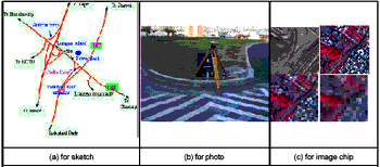
Figure 1.The typical exa mple of GCP database image attributes

Figure 2. Image map on CRT
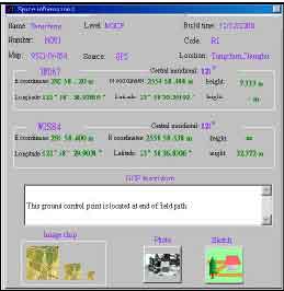
Figure 3. The query result of GCP database on CRT
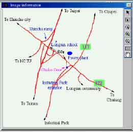
Figure 4. The display of sketch on CRT
Testing GCP
Three testing GCPs are selected and located at south, middle and north of China Taipei. To scan an existing map is an easy way to get the coordination of a GCP (Shin 1996). But the accuracy is very poor and is not good enough for the high-resolution image. The geographical coordination is measured with GPS with required baseline from the national reference GPS points. The accuracy of geographical coordination for each GCP is at the order of centimeters and it is far better than required accuracy of ROCSAT-2 images.
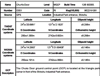
The attributes are collected for the three testing GCPs in the study. They represent for the city, country and mountain areas, respectively. The attributes of the north testing GCP are summarized as Table 4.
Conclusions
To precisely correct geometric distortion, GCP of China Taipei area is urgently needed. A distribution of GCPs was studied. The attributes of GCP were summarized. A database management was applied for those GCPs. The user edits, inputs, outputs, displays and inquires the attributes of the GCP with the database management. The attributes of three testing GCPs were collected and the north one was demonstrated in the study. The attributes of more GCPs of China Taipei are to be completed in the near future.
Acknowledgements
The project was funded by NSPO under contract NSC89-NSPO(A)-PC-IC01-02.
References
- Wang, H. C., Lee, L. C., Ling, J., and Wu, A. M., 2000, ROCSAT- 2 Remote Sensing Mission, Presented at 51st International Astronautical Congress, October 2-6, 2002, Rio de Janeiro, Brazil
- Chang, C. L., Wu, C. N. and Chern, J. S., 2002a, An Investigation on the Requirements and Applications of Remote Sensing for ROCSAT-2 Program, Proceeding of SE2002
- Chang, C. L., Wu, C. N., Liao, T. Y, and Hsiao, C., 2002b, ROCSAT -2 Spectral Reflectance Experiments Using Local Three End-member Spectral Mixed Model in China Taipei , Presenting at SPIE RS Conference, Crete Greek, September 23, 2002
- Lee, Y. R., Shin, D., Lee, H. Y, 1998, Construction Search of Ground Control Points Database and its Application for Satellite Image Correction.Shi n, D., 1996, On Feasibility of Using Scanned Maps for Ground Control Point Marking, Journal of Korean Society of Remote Sensing.
- CNES and SPOT IMAGE, 1997, Specification for simplified SPOT Location Model, C047.ST.73.104.SI, Rev. 0