| GISdevelopment.net ---> AARS ---> ACRS 2000 ---> Water Resources |
Identification and Mapping of
New Maruganga Channel in Northwest India of Indian Sub-Continent
Dr. Narpat Singh
Rathore
Department of Geography, M.L. Sukhadia University,
Udaipur - 313 001 (Raj.) India
Fax: +91 294 415200,
E-mail: kksud@yahoo.com
Department of Geography, M.L. Sukhadia University,
Udaipur - 313 001 (Raj.) India
Fax: +91 294 415200,
E-mail: kksud@yahoo.com
Abstract
In this study the main focus is upon harnessing the water resource potential of perennial river originating from the Himalayas in order to irrigate the arid and semi-arid part of north-west India. The remote sensing technique offers great scope in providing identification and mapping of link channel for two different rivers which flow in two different directions. The present study is an attempt to use remote sensing technique for preparing the development plan for Indian desert and semi-desert regions through diverting the flood waters of the Himachal Himalayas and Uttrakhand without lifting towards Western Rajasthan and Northern Gujarat Plains. The study revealed that after the implementation of the proposed plan, north-west India will be largest food grain producing and irrigated area of the world. The significance of the plan could be compared to the status of the Kaveri River in South India and Nile River in Egypt.
Study Area :
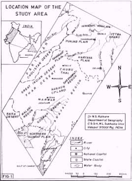
The present study area lies between 21o45' north to 33o00' north latitudes and 70o00' east to 78o00' east longitudes. Geographically this region is the part of desert and semi desert of north-west India in the Indian Sub-continent (Fig. 1). The new Maru-Ganga channel will flow from Punjab, Haryana, Rajasthan and Gujarat states of India. Climatically this region falls in the arid and semi-arid part of north and west India. The characteristic features of the climate of the areas is its dryness, extremes of temperature, erratic nature of the rainfall, high evaporation and wind velocity. The average annual rainfall is only 370 mm. The minimum temperature often falls below freezing point in January and maximum temperature recorded during the month of May and June is 40o to 45o centigrade. The region is swept by dust storms and thunder storms during summer and pre monsoon months. More than ninety per cent of rainfall occurs in the months of July to September every year. Only some amount of rainfall is received by western disturbance in winter season.
Material and Methods:
The study area is covered in 15 satellite imagery i.e. different dates in black and white and colour composites transparency and paper prints for visual interpretation. The false colour transparency of million scale was brought on 1:2,50,000 scale to make the study comprehensive. Indian topographical sheets and maps were also used for study purpose. The details of satellite imagery and topographical maps are given in Table-1. For the visual interpretation of the remotely sensed data, ground truth collection and field verification are essential to eliminate the doubts and hence, ground truth data have been collected from the field. Apart from the data inferred from the satellite imagery, topographical maps and field survey, the relevant data were also collected from secondary sources
| Satellite Imageries | |||
| Satellite Type | Row No. | Path No |
Topographical Sheet No(Survey of India) |
| IRS-IC WiFS IMAGE (NRSA) | 47 47 47 48 48 49 49 49 50 51 |
30 31 32 30 31 31 32 33 33 33 |
40 - O and P 41 - M and N 44 - K,L,N,O, and P 45 - A,B,C,D,E,F,G,H,I,J,K and L 46 - ABCE and F 53 - ABCD National Atlas of India, Plate No. 1,3,25,27,28 and 31 |
| LANDSAT - 4 (NRSA) | 149 | 042 | |
| LANDSAT - 2 (NASA) | 160 | 039 | |
| LANDSAT - 1 (NASA) | 189 189 189 |
1136 1373 1582 |
|
Significance of Study :
The proposed identified new Maru-Ganga river's Channel length will be near about 15 hundred km right from Himachal Himalayas to Gulf of Cambay of Arbian Sea in Gujarat State. However, after the Brahmaputra, Ganga and Godawari rivers the new Maru-Ganga river will be the 4th Major river of India in length. The proposed Maru-Ganga river will be 16th major river in terms of length in the Asian continent and 30th river in the world. This river will carry water of Himalayas through Indian desert and ultimately merge in the Gulf of Cambay in Gujarat State. After implementation of this plan, the north-west India will get permanent relief from natural calamities like flood, famine and drought. After implementation of the plan cattle migration will stop, saline water will be converted into potable water, and under ground water level will rise, protect the cattle wealth of the region, produce additional foodgrains, green vegetable and fruit. The Bhakra, Gang and Indira Gandhi canal command area will get permanent relief from water logging problem. With this plan Bahawalpur region of Pakistan and Delhi Indian national capital region will get relief from flooding during rainy season of Ghaggar and Yamuna river respectively.
In the Luni-basin and Nothern Gujarat by the implementation of this plan the area will produce large amount of Coconut, Banana, Mango, Date, Green Vegetable, Spices and milk. Due to the availability of solar and wind energy alongwith Himalayan water new Industries can be established in the study area.
Analysis:
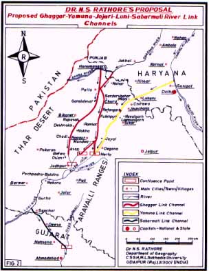
During the rainy season, large amount of floodwater is available in the Himachal Himalayas and the Uttrakhand region of the Himalayas. This flood water goes waste through the Ghaggar and the Yamuna river respectively into Pakistan and the Bay of Bengal. For the development of the Indian desert and semi desert areas this floodwater can be diverted without lifting towards Rajasthan and the North Gujarat Plain. The floodwater of Punjab rivers and also the Yamuna river can be diverted through three link channels (Fig. 2). These link channels are the Ghaggar link channel, the Yamuna link channel and the Sabarmati link channel. Through these channels the Himalayan diverted flood water will reach the Arabian Sea through the Gulf of Cambay. The details of proposed newly identified channels are:
Ghaggar Link Channel:
The arid and semi arid regions of Rajasthan and Gujarat state can get many million cubic meters of water through proper management and diversion of Himalayan water. In rainy season large amount of floodwater flows into the Ghaggar river. This flood water can be diverted by the removal of soil from Hanumangarh to Pallu, Napasar, Deshnok, Chadi, Danwara, Jodhpur or Pallu, Sardar Shahar, Tal-Chapper, Nagaur , Asop, Bhopalgarh, Jodhpur or Nagaur to Merta by the removel of soil. By these route the Himalayan water can be dropped into Jojari-Mithari river. Ultimately this diverted water flowing naturally will reach near Salawas or Khejari Khurd and meet with Luni river.
Yamuna Link Channel:
In the same rainy season the Uttarakhand region of Himalayas also gets large amount of water due to heavy rain and flood situation occurs in the Yamuna river every year. This flood water of Yamuna river which is released from Tejawala feeder can be diverted from Sonipat by removing the soil of Rohatak, Mahendragarh and Hissar districts of Haryana state and Jhujhunu, Mandawa, Mukundgarh, Sikar, Didwana, Degana and Merta in Nagaur district. The diverted water will reach Merta and join with Mithari-Jojari river. From Merta onwards this Yamuna water which will naturally flow and go towards Ghaggrana; Ghorawat, Pipar and Bisalpur. This Yamuna water will meet with Luni river near Jodhpur at Khejarli-Khurd. However, the Ghaggar and Yamuna diverted flood water will meet near Khejarli Khurd or Luni village with Luni river. This water will reach Samdari, Balotra, Sindari, Dhorimana, Guda and ultimately reach near Sanchore in Jalor district.
Sabarmati Link Channel: However, that proportion of the Himalayan water which is flowing in the Luni river and which goes into Rann of Kachch through delta will remain unharnessed. So by the third channel constructed by the removal of soil from Sanchore to Dissa, Palanpur, Sidhpur, Mesana and Ahmedabad of Gujarat State, the Luni river can be linked with Sabarmati river. By this way, the joining of the Himalayan water with new proposed channel, in the Northwest India of the Indian sub-continent will be called Maru-Ganga.
Results:
In the state of Rajasthan the Hanumangarh, Churu, Jhunjhunu, Sikar, Nagaur, Bikaner, Jodhpur, Pali, Barmer and Jalore districts will get additional irrigation of 12 lakhs hectares land, 5 lakhs hectares of grazing land, 50 thousand sq. km underground water will be re-charged and 25 lakhs tons additional foodgrain can be produced every year. In the Gujarat State, Banaskanta, Dissa, Palanpur, Sidhpur and Ahmedabad will also get additional irrigation facilities for 2 lakh hectares, in 10 thousand sq. km underground water level will be re-charged and 5 lakhs tonnes foodgrain will be produced. The proposed river channel will protect wild life and migratory birds of this region and also conserve the environment and eco-system of the surrounding area of the new Maru-Ganga channel. The area which falls between the Thar Desert and Aravalli mountain region like Churuthal, Shekhawati, Shalkh or Nagaur upland, Marwar, Godwar, Malani and northern Gujarat where the agriculture land will be irrigated by the diverted Himalayan water.
Conclusion:
After implementation of this plan, the rivers of North India will be linked with Southern India rivers through Rajasthan desert with help of newly identified Ghaggar, Yamuna and Sabarmati link Maru-Ganga Channel. Desert soil area linked with fertile black soil region of Southern India through this new plan. To complete the proposed plan it will be possible only with the help of special financial assistance from the Central Government in collaboration with State Government in three stages. In first stage Ghaggar channel, in second stage Yamuna channel and finally the third stage Sabarmati link channel can be made and complete the whole plan. After that the Western India will be largest foodgrain producing and irrigated area of the world. This new river channel will join Himalayas, Desert and sea. In the 21st century the important event will take place if joining of these three major geographical regions of Indian sub-continent by the new identified channel.
Acknowledgements:
The author is grateful to Dr. J.R. Sharma, Director, Regional Remote Sensing Service Centre, Jodhpur for providing remotely sensed data in the form of Satellite imagery to carry out this work. Author is also thankful to Prof. A.K. Singh, Vice-Chancellor of M.L. Sukhadia University, Udaipur for giving consent and encouragement for research work. I am indebted to Prof. K. K. Sud, Dr. L.S. Rao, Dr. K.N. Joshi for giving valuable comments and suggestions. Thanks are also due to Mr. M.L. Ameta for cartographic work.
References
- OLDHAM, C.F. (1874). Notes on the lost river of the Indian Desert,
Calcutta Rev., V.59, pp.1.27.
- OLDHAM, R.D. (1886). On probable change in the geography of the
Punjab and its rivers - a historic-geographical study. Jour. Asiatic
Soc. Bengal. V55. pp 322. 343.
- RAMASAMY, S.M., BAKLIWAL, P.C., and VERMA R.P. (1991). Remote
Sensing and River Migration in Western India. Int. Jour. Rem. Sens. V
12,(12), pp.2597-2609.
- RAO, D.P. (1999). Role of remote sensing in understanding of
palaeodrainage evolution, Vedic Sarasvati, Memo. Geol. Soc. India, No.42
pp.237-244.
- RAO, K.L. (1979). India's Water Wealth, Orient Longman Ltd., New
Delhi.
- RATHORE, N.S. (1989). Rajasthan State, Nehru a Panoramic Profile,
M.L. Sukhadia University, Udaipur.
- RATHORE, N.S. (1992), Natural Resources Base Development. Scientific
Publishers, Jodhpur.
- THUSSU, J.L. and CHOPRA, S. (1994). Channel migration and phenomenon of Terminal Fan Formation in some of the major Streams of the Ghaggar River Basin of Haryama. NW India. Indian Minerals V. 48, No.4, pp.255-272.