| GISdevelopment.net ---> AARS ---> ACRS 2000 ---> SAR/InSAR |
921 Chichi Earthquake :
Preliminary Interferometric Interpretations
Deffontaines
B.1, Liang L.S.2, Pathier E.1, Wang C.T.
2, Fruneau B.3, Lee C.T.4,
Raymond D.1, J.Angelier1 and Rudant J.P.3
Centre National de la Recherche Scientifique ESA 7072,
and Université Pierre et Marie Curie,Paris, France,
Remote Sensing Center Chungli, National Central University,
Chungli,TAIWAN
Université de Marne-La Vallée, France
E-mail : benoit.deffontaines@lgs.jussieu.fr
Keywords : Chichi Earthquake, 921,
Neotectonics, Active Faults, SAR-ERS, Interferogram, Foothills, Taiwan.
Raymond D.1, J.Angelier1 and Rudant J.P.3
Centre National de la Recherche Scientifique ESA 7072,
and Université Pierre et Marie Curie,Paris, France,
Remote Sensing Center Chungli, National Central University,
Chungli,TAIWAN
Université de Marne-La Vallée, France
E-mail : benoit.deffontaines@lgs.jussieu.fr
Abstract
Taiwan island displays active tectonics expressed by high seismicity. The 921 Chichi earthquake (Mw= 7.3 - Foothills, Western Taiwan), occured last 21st September 1999 at 1 :47am. By SAR-ERS interferometry, we show herein the deformation field in the western side of the active Chelungpu thrust fault (Taichung area) induced by the Chichi earthquake. It shows a slight subsidence, with a maximum displacement of 30cm. This new methodology combined to precise GPS measurements, field work (trenching, fault and syndeposits analyses), geophysics, sismologist and morphotectonic works, lead to a better knowledge of active faults in Taiwan.
Introduction
Taiwan is located on plate boundaries between both Philippine and Eurasian plates to the East and West respectively. This island shows a spectacular compressional tectonics, underlined by a recent mountain range culminating almost at 4.000m. Otherwise, the present deformation is also expressed by high seismicity, including the last destructive Chichi earthquake (21.09.99), and by less known slow deformations, partly recorded by G.P.S methods. Our aim in this paper is to better know the deformation field within the Chichi area, so we have carried out SAR interferometric studies in the western part of Taiwan (Taichung cities and surrounding areas).
After a brief review of Taiwan geodynamical setting, and Western coastal plain geological features, we present herein three new and complementary SAR interferogram of the studied area, evidencing the tectonic deformation linked to the earthquake. One may notice the major contribution of these results for a better knowledge of natural hazards of tectonic origin in this densely populated area.
Taiwan geodynamical setting (fig 1)
To the NE of Taiwan, the Philippine plate subducts towards the Northwest beneath the Eurasian plate into the Ryukyu arc-trench system. Contrasting to the S of Taiwan, where the Philippine plate, bounded by the Luzon volcanic arc, overrides towards the West the South China Sea oceanic crust into the Manilla trench. This latter subduction is transformed northward and onshore into a collision between Philippine and Eurasian plates. Therefore Taiwan is an accretionary prism linked to this collision. The obliquity between the Chinese continental margin (Eurasian plate) and the Luzon volcanic arc (Philippine plate) involves a progressive migration towards the South of the active collision (e.g. Biq, 1972; Bowin et al., 1978; Wu, 1978; Suppe, 1981; Ho, 1986). A present 70 mm/yr northwestern relative motion between Philippine and Eurasian plates, predicted by Seno et al. (1977, 1993) has been recently raised to 81 mm/yr according to GPS measurements (Yu et al., 1997).
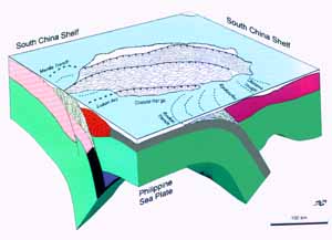
Fig. 1. Taiwan geodynamical setting
The Philippine Sea Plate subduct under the Eurasian plate to the NE and is overriding the Eurasiatic plate to the SW (from Angelier 1986-99).
SAR interferometry data acquisition and processing (table 1)
With the aim of detecting deformations linked to Chichi earthquake, we have analysed the western Foothills of Taiwan, in the Taichung area, by the means of SAR interferometry. This method has already been used for recording and measuring ground "fast" motions linked to earthquakes (normal and strike-slip faults, volcanic eruptions, and landslides (Massonnet & Feigl, 1998). But it is the first time that a thrust to be studied with this methodology. The problem with Chichi earthquake is to get good base line (distance between the two satellites orbits) in order to get rid of topographic artefacts. Unfortunately, with SAR-ERS2 the dates close to the September 21st are of poor base lines which imply to take into account longer time interval before and after the 921 quake. Consequently, an interferogram with a long time interval between the two images involve a coherence loss. Nevertheless, weak ground motions have been already characterized by the means of interferograms with long intervals (until 3 years) either in desert areas like Iceland (Vadon & Sigmundson, 1997), within towns like Paris (Fruneau & al. 1998) or within a compressive environment in Tainan (Taiwan, Deffontaines et al., 2000). In Taiwan, SAR interferometry use for ground motion measurements is difficult because coherence problems induced by extensive tropical vegetation, water stretches, rice and tea crops. In this context, the Foothills is nevertheless a good target because this area is rather low relief, with several important towns connected by wide suburbs, so favourable to a coherence preservation, during a long time (Deffontaines et al., 2000).
The Taichung studied area is covered by several ERS-SAR 2 frame (descending and ascending orbits). Among the frames, we have selected, with the help of ORBISCANÓ (CNES) software several pairs of interferometrable images (track 232 and frames 3123, see table 1 for parameters).
Processing of the images had been done using the DIAPASONÓ (CNES) software which lead to interferogram where the effects of satellite geometry and topography are removed using 80m ground resolution digital terrain model (hereafter DTM).
|
|
|
|
|
|
|
|
|
|
|
|
|
|
|
|
|
|
|
|
|
|
|
|
|
|
|
|
|
|
|
|
|
|
|
|
Table 1 : Characteristics of the different ERS-2, 3123/232 interferograms realized
Results and interpretation (Fig.2A-B, 3, 4, 5)
On the amplitude image (Fig.2A), one may notice Taichung and surrounding city buildings (white pixels), fish ponds, rice fields and rivers (black pixels), Taiwan strait and vegetation onshore (grey pixels). From the processing of interferometrable image pairs, we have carried out calculation of several interferograms (e.g. Fig.3, 4 and 5) and coherence images (e.g., Fig. 2B). White pixels on the coherence image correspond to coherent points on the two radar images such as urbanized areas. The corresponding interferogram (Fig. ) and fringes on the western down-faulted block of the Chelungpu fault (Chichi earthquake). The rather low base line of the pair (100m in the specific area of Taichung) linked with low relief, logically suppresses fringes, due to topographic artefacts for example to DTM errors. Otherwise, with the aim of avoiding the hypothesis of parasitical fringes occurrence generated by atmospheric effects, we have to carried out other interferograms with independent pairs of images (work in progress).
So without parasitically effects, the interferograms (fig.4) shows particularly a serie of 10 complete fringes to the W of the Chelungpu fault. We interpret these fringes as corresponding to a present displacement witness.
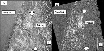
Fig.2A : Amplitude image of the Taichung area (23/09/1999 - SAR-ERS) ; 2B : Coherence image of the Taichung area (02/25 ~ 09/23 pairs). White pixels = coherent points (e.g. : urbanized areas), black and grey ones = not coherent (sea water, and vegetation).
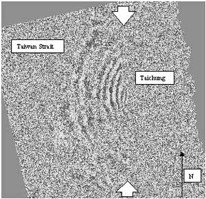
Fig. 3 : Non ortho-referenced interferogram (02/25 ~ 09/23) of the Taichung area
Note the 10 fringes in the western down-faulted block of the Chelungpu active Fault (location between white arrows)
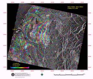
Fig. 4: Ortho-referenced interferogram (05/06 ~ 09/23) of the Taichung area
(Intensity : Amplitude, Hue : Phase - interferogram, Saturation : Coherence)
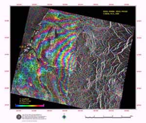
Fig. 5: Ortho-referenced Interferogram (05/06 ~10/28) of the Taichung area
(Intensity : Amplitude, Hue : Phase - interferogram, Saturation : Coherence)
One may notice on fig. 2B and consequently on Fig. 3, 4 and 5, the absence of interpretable interferometric data on the eastern side of the Chelungpu Active Fault due to the large amount of displacement, the large destructions of buildings, the differenciate relief and the luxuriant vegetation. In contrast, the western down-faulted block displays almost 10 fringes interpreted herein as deformations due to the Chichi earthquake as the high base line, and the low relief of the studied area avoid classical topographic artefacts. The coherence of the three independant interferogram shown here lead also to minimize atmospheric artefacts.
On the Taichung basin, the calculated interferograms shown here, present coherent 10 to 11 phases variation modulo 2P. As the radar wavelength of SAR-ERS2 is 2.8cm, the down-faulted side of the Chelungpu thrust reaches almost 30cm of subsidence linked to the 921 Chichi earthquake. In order to get both horizontal and vertical component of this deformation, we have taken GPS data into account (work in progress with Yu S.B.). Our preliminary results combining both interferogram and GPS data show the pretty good accordance and highlight the complementarity. Especially, one may notice the interest of interferograms which show spatially the maximum area of deformation of the Western block of the Chelungpu active fault in east Taichung city, within a gap of GPS stations. The maximum of subsidence area revealed by SAR interferograms is coherent to the maximum of destructions of buildings in the city. This is closely linked to the geometry of the fault which is not a uniform fault plan and present several re-etrent (Deffontaines, 2000). The further direction of studies deal with the vertical variation of water-table which also might produce centimetric ground deformation on interferograms (work in progress).
Conclusions
The preliminary interferograms linked to 921 Chichi earthquake (Taiwan) reveal spatially the western deformation field of the Chelungpu Active Fault. It is the first example of interferogram linked to active thrust in the world studied by SAR interferometry. Such studies of active deformation within high anthropic area such as the Taichung county (third city of Taiwan) shows how important is this interferometric approach to better locate, characterise, quantify and modelize natural hazards due to tectonic effects. This interferometric approach had to be combined with classical field data (trenching, and morphotectonic studies), and with GPS, levelling, geophysics and seismological approach in order to better constrain the active faults of Taiwan.
Acknowledgments
This research has been done with various supports from the Taiwan-France cooperation program supported by the French Institute in Taipei (IFT), the National Science Council (NSC), the Ministry of Education of Taiwan, the French National Center of Spatial Studies (C.N.E.S) and the European Spatial Agency (E.S.A.) and within a collaboration between University Pierre and Marie Curie and the National Central University (Chungli) and the remote sensing of NCU-Chungli.
References
- Angelier J., Chu H.T., Lee J.C., Hu J.C., Lu C.Y., Mouthereau F., Font Y., Deffontaines B., Chow J.D., Tsai Y.B., Chan Y.C., Lin T.J., 2000. How can geologists efficiently contribute to seismik risk mitigation ? The ChiChi earthquake case, Taiwan, Taiwan Natural Mitigation, Taipei, 21-26/05/2000,
- Biq C.C., 1972. Dual trench structure in the Taiwan-Luzon region. Proc. Geol. Soc. China 15:65-75
- Bowin C., Lu R.S., Lee C.S. and Schouten H., 1978. Plate convergence and accretion in the Taiwan-Luzon region. Am. Assoc. Pet. Geol. Bull., 62: 1645-1672.
- Deffontaines et al. 1995 TEA colloquium Chungli
- Deffontaines B., Lee J.C., Angelier J., Carvalho J., Rudant J.P. 1994: New geomorphic data on Taiwan active orogen: a multisource approach, Jour. Geophys. Res, 99, B10: 20,243-20,266.
- Deffontaines B., Lacombe O., Angelier J., Chu H.T., Mouthereau F., Lee C.T., Deramond J., Lee J.F., Yu M.S., Liew P.M., 1997. Quaternary transfer faulting in Taiwan Foothills: Evidence from a multisource approach, Tectonophysics, 274, 1-3: 61-82.
- Deffontaines B., Fruneau B., Pathier E., Raymond D., Lee C.T., Angelier J., Wang H.T., Rudant J.P., 2000. Long time SAR Interferometry for detection active ground motions: The Tainan anticline (SW Taiwan), Taiwan Natural Mitigation, Taipei, 21-26/05/2000.
- Deffontaines, C.T. Lee, E. Pathier, J.Y.H. Yu, B. Fruneau, H.H. Chen, L.S. Liang, A.J. Chen, S.K. Chen, D. Raymond, C.L. Tseng, J.P. Rudant, Y.B. Tsai, J. Angelier, C.P. Chang, T.Y. Chang, F.C. Li, C.T. Wang, H.H. Hsi, 2000. preliminary interferometric results on 921 chichi earthquake (central taiwan), Proc. Int. Workshop on annual commemoration of Chichi earthquake, Vol1. Science aspect 18-20/09/2000, 105-110.
- Delcaillau B., Deffontaines B., Floissac L., Angelier J., Deramond J., Souquet P., Chu H.T., Lee J.F., 1998. Morphotectonics in the Western fold-and thrust belt of Taiwan: an integrated analysis of the Pakuashan anticline, Geomorphology, 24 : 263-290.
- Fruneau B., Rudant J.P., Obert D., Raymond D. (1998) Small displacements detected by SAR interferometry on the city of Paris (France). Proceeding of the 2nd International workshop on retrieval of bio- and geo- physical parameters from SAR data for land applications, 21-23 October 1998, Noordwijk, The Netherlands, p.557-563.
- Ho C.S., (1986). A synthesis of the geologic evolution of Taiwan. Tectonophysiscs, 125: 1-16.
- Huang C.Y., Wu W.Y., Chang C.P., Tsao S., Yuan P.B., Lin C.W., Yuan X.K. (1997). Tectonic evolution of accretionary prism in the arc-continent collision terrane of Taiwan. Tectonophysics, 281, 31-51.
- Massonnet D., Feigl K., (1998). Radar Interferometry and its application to changes in the earth's urface . Reviews of Geophysics, 36, 4: 441-500.
- Okada Y., (1985). Surface deformations due to shear and tensile faults in a half-space, Bull. Seism. Soc. Am., 75 : 1135-1154.
- Seno T., 1977. The instantaneous rotation vector of the Philippine Sea plate relative to the Eurasian plate. Tectonophysics,42:209-226.
- Seno T., Stein S., Gripp A.E., 1993. A model for the motion of the Philippine Sea Plate consistent with Nuvel-1 and geological data, Jour. Geophys. Res., 98 : 17.941-17.948.
- Suppe, J, 1981. Mechanics of mountain-building and metamorphism in Taiwan: Mem. Geol. Soc. China, 4, 67-89.
- Vadon H., Sigmundsson F., (1997). 1992-1995 crustal deformation at Mid-Atlantic ridge, SW Iceland, mapped by radar interferometry. Science, 275, 194-197.
- Wang and Liang Juillet 2000 Interferometric results on Chichi earthquake.
- Wu F.T., (1978). Recent tectonics in Taiwan. J. Phys. Earth, 26, S265-S299.
- Yu S.B., Chen H.Y., and Kuo L.C., 1997, Velocity field of GPS stations in the Taiwan area, Tectonophysics, 274 : 41-59.