| GISdevelopment.net ---> AARS ---> ACRS 2000 ---> Poster Session 3 |
Prospect for the Method of
Urban Safety Analysis and Environmental Design
Osamu MURAO and Fumio
YAMAZAKI
Institute of Industrial Science, University of Tokyo
4-6-1 Komaba, Meguro-ku, Tokyo, 153-8505
Tel: (81)-3-5452-6388, Fax: (81)-3-5452-6389
E-mail: murao@iis.u-tokyo.ac.jp
JAPAN
Keywords: Information Technology, GIS, Digital
City, Urban Simulation, Urban Safety Planning
Institute of Industrial Science, University of Tokyo
4-6-1 Komaba, Meguro-ku, Tokyo, 153-8505
Tel: (81)-3-5452-6388, Fax: (81)-3-5452-6389
E-mail: murao@iis.u-tokyo.ac.jp
JAPAN
Abstract
In Japan, it is important to carry out urban planning considering natural disasters, because earthquakes occur frequently. However, except for few cases, cities in Japan have not been designed with any definite visions for urban safety based on previous research concerning natural disasters. It is necessary for the people in Japan to propose a future vision of a city from the urban safety point of view, as it has been plagued with many earthquakes throughout history. On the other hand, recent information technology enabled the improvement of real-time monitoring systems after the 1994 Northridge Earthquake and the 1995 Kobe Earthquake. The authors proposed a method of analyzing and designing a city based on the urban safety point of view in previous papers. This method, named as MUSE (the Method of Urban Safety Analysis and Environmental Design), is based on the theory of The Image of the City by Lynch (1961), and some urban physical elements are defined as parts of an organic system. In this paper the prospect for MUSE and the methodology to realize it are described. The proposed system is related to Information Technologies and we expect that MUSE will be applied to early earthquake damage assessment systems.
Introduction
Recent rapid development of information technologies, i.e., Internet, Mobile Computing, Remote Sensing, Virtual Reality, etc., have changed our social life in various fields. This remarkable innovation also affects the field of urban safety planning or disaster mitigation. Cooperating with these latest information technologies, some human activities for disaster mitigation could be shifted into a new paradigm. Especially, GIS technology will be an effective means, because the spatial viewpoint is indispensable not only for the field of physical environment like urban planning but also for human activities. In fact, a lot of researches with GIS have been carried out since the 1994 Northridge Earthquake and the standardization of spatial data infrastructure as ISO/TC211 is globally under development. In the field of architectural design, some architects (e.g., Frazer, 1995) have discussed new possibility of Cyber City or Cyber Architecture. However, the expected new concept of cyberspace might be only artistic expression on the monitor without awareness of urban problems in the real world. Linking the real world and the cyberspace together to solve the concrete urban problem, the new life style in the IT era will be realized. Based on the above social background and the previous research (e.g. Murao et al., 2000), the present authors proposed a method named MUSE (the Method of Urban Safety Analysis and Environmental Design) to analyze a city from the viewpoint of urban safety (Murao and Yamazaki, 1999). This paper focuses on the prospect to realize MUSE.
Outline of "MUSE "
MUSE (the Method of Urban Safety Analysis and Environmental Design) is based on the theory of The Image of the City by Lynch (1961), and some urban physical elements are defined as parts of an organic system in GIS. This is a method to analyze or recognize urban phenomena. It will be able to simulate and design cities optimally according to each condition. The physical elements are classified into the following 10 types.
Element-0: Imaginary Walls
Element-I: Subjects (as Physical Dynamic Elements): people, bicycles, cars, trains, etc.
Element-II: Shapes (as Physical Static Elements)
a. Paths (Leading Paths and Secondary Paths): streets, expressways, alleys, railways, etc.
b. Edges: coastlines, riverbanks, long walls, edges of developed districts, etc.
c. Cells: town blocks, etc.
d. Voids: open spaces, public squares, parks, playgrounds, campuses, parking lots, etc.
e. Cores: city halls, ward offices, elementary schools, hospitals, etc.
Element-III: Webs (as Systematic Elements): common ducts, lifelines, water supply, etc.
Element-IV: Nature (as Natural Elements): ponds, lakes, rivers, green belts, farms, etc.
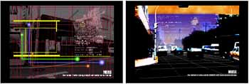
With the classified spatial data for GIS, inventory and statistical data, and the latest information technologies (e.g., high quality computers, GPS, Remote Sensing, Virtual Reality, Augmented Reality, Ubiquitous Computing, Cyber Architecture, etc.), we hope to have remarkable improvement in the field of disaster mitigation (Figure 1).
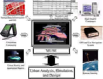
Figure 1 Cooperation between Information Technologies and MUSE
Methodology of "MUSE SYSTEM"
Outline
The comprehensive system among MUSE and the information technologies to realize the vision (Figure 1) was named as MUSE System. This system consists of three fields, namely, Semantics, Syntactics, and Pragmatics (Figure 2). Semantics is the field in relation to the classification and the definition of spatial data. Syntactics deals with the relationship between the spatial data and other elements (i.e., time, location, and social systems). Pragmatics is the field in connection with the application of the information to the real social life for people.
Semantics
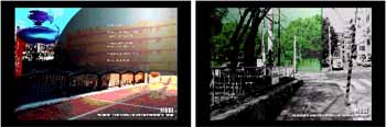
Semantics is the field that deals with the relationship between the digitized GIS spatial data and the physical elements of the city. In this stage, the physical elements and the spatial data are classified into some categories and the vocabulary of spatial data is defined clearly. For example, the element named "Edge" (coastlines, riverbanks, or long walls, etc.) is usually negative element that interrupts traffic activities (Figure 3). However, the element can be positive one to prevent fire spread in case of a big fire caused by an earthquake. The purpose of Semantics is to make a dictionary of urban spatial data which have some meanings depending upon circumstances. The standardization of spatial data infrastructure as ISO/TC211 is globally under development. GIS is an important tool to share the spatial information among users. Therefore, Semantics in MUSE System should be established in the global standardization.
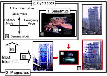
Figure 2 Process to realize MUSE
Syntactics
Syntactics is the field that deals with the relationship between the spatial data prescribed by Semantics and other elements, i.e., time, location, and social systems (e.g., economy or the laws and regulations). As a result, it will be possible to simulate the various urban phenomena as well as damage assessment of the city. Environmental Systems Research Institute, Inc. evaluates GIS ModelBuilder, which was developed for GIS simulation, as one of the most promising extended function in the next generation. Figure 4 (L) shows a flow chart of Erosion Hazard simulation including some ground condition by GIS ModelBuilder. The round shaped node represents a function to estimate each condition and each function can be changed for a more accurate and improved urban simulation according to the progress in the research field. The construction of the method to grasp the urban activities is a principal subject of Syntactics. There are two axes for the simulation in this stage as shown in Figure 2. One of them is the axis in connection with its use, the ordinary mode and the emergency mode. Another one is related to the time period to input data, the static mode and the dynamic mode. The static mode is used for the simulation with slow updating data like those for disaster management, which is not necessary to update data every day or every week. On the other hand, the dynamic mode is the real-time simulation in Internet or Ubiquitous-computing environment. The concept of the urban simulation will be a new method to recognize and design cities in the next century. For instance, a local government whose budget is limited can determine the optimal location of open space as a result of a fire spread simulation shown in Figure 4 (R). It is time to realize the symbioses of the Real City and the Invisible City with information technologies and spatial data infrastructure as Crane (1960) described 40 years ago.
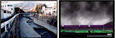
Figure 3 Meaning of "Edge"
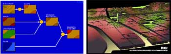
Figure 4 GIS ModelBuilder © 2000 ESRI (L) and Urban Simulation of Fire Spread (R)
Pragmatics
Syntactics is to recognize the social activities in a city through a computer monitor. How people deal with data or information in the social real life should be considered in Pragmatics field. One of the final goal of this stage might be realization of Augmented Reality (Feiner et al., 1999) for disaster mitigation, in which people can get useful information of real objects in a person's presence through HMD (Head Mounted Display). Construction of a 3D Digital City Database is indispensable for it. One of the important subjects of this field is how automatically the spatial data could be updated according to the change of a city. Some information technologies like remote sensing, laser scanning, and positioning system can be helpful to solve the problem. The future vision in the field of disaster mitigation is shown in Figure 5. Figure 5 (a) is the utility data for residential buildings with its location projected on a monitor. Using this application, it is easier to find out the hidden damaged part of the utility after an earthquake. Figure 5 (b) shows the real-time traffic information on a car window based on the dynamic simulation described in 3.3. This will be useful for local governments or the public to grasp the traffic condition of a city. Figure 5 (c) shows the emergency information on a hospital just after an earthquake (e.g., the number of available beds, the number of doctors on duty, etc.). Figure 5 (d) is the image of the evacuation area led by HMD. The vision, which indicates a new relationship in the 21st century among information, human activities, and disaster mitigation, will be realized through the three stages by the linkage of the latest information technologies.
| (a) Lifeline Data of House Projected on Monitor |
(b) Traffic
Information on a car window |
| (c) Emergency Information on Hospital | (d) Evacuation Area led by HMD | |
Figure 5 Application of MUSE to Urban Safety | ||
Conclusions
The authors proposed a method named as MUSE (the Method of Urban Safety Analysis and Environmental Design) to analyze a city from the viewpoints of urban safety. In MUSE, some urban physical elements are defined as parts of an organic system in GIS to analyze or recognize urban phenomena. Also, a future vision in connection with disaster mitigation was suggested. In this paper the prospect for MUSE was described. The comprehensive system of MUSE and the information technologies to realize the vision was named MUSE System. This system consists of three fields, namely, Semantics, Syntactics, and Pragmatics. Semantics is the field in relation to the classification and the definition of spatial data. Syntactics deals with the relationship among the spatial data and other elements (i.e., time, location, and social systems). Pragmatics is the field in connection with the application of the information to the real social life for people. The vision, which indicates a new relationship in the 21st century among the information, human activities, and disaster mitigation, will be realized through the three stages by the linkage of the latest information technologies.
Acknowledgements
The authors would like to express their gratitude to Prof. Steven K. Feiner and Prof. Peter K. Allen of Columbia University, Federal Emergency Management Agency, Mr. Ronald T. Eguchi of ImageCat, Inc., Environmental Systems Research Institute, Inc., Pasco Corporation, Prof. Ryosuke Shibasaki of University of Tokyo, and The foundation for the promotion of Industrial Science, for the support of the investigations in this paper.
References
- Crane, D., (1960). "City Symbolic," AIA.
- Frazer, J. H., (1995). "The Architectural Relevance of Cyberspace," Architectural Design: Architects in Cyberspace, 76-81.
- Höllerer, T., Feiner, S. and Pavlik J., (1999). "Situated Documentaries: Embedding Multimedia Presentations in the Real World," Proceedings of ISWC '99 (International Symposium on Wearable Computers), 79-86.
- Lynch, Kevin, (1960). The Image of the City, MIT Press.
- Murao, O., Tanaka, H., and Yamazaki, F., (2000). "New Method for Building Collapse Risk Assessment Based on Damage Data Due to the 1995 Kobe Earthquake," Proceedings of the 12th World Conference on Earthquake Engineering, CD-ROM, No.2312, 8p, Auckland, New Zealand.
- Murao, O., and Yamazaki, F., (1999). "Use of GIS for the Method of Urban Safety Analysis and Environmental Design," Proceedings of the 20th Asian Conference on Remote Sensing, Vol. 2, 951-956, Hong Kong.