| GISdevelopment.net ---> AARS ---> ACRS 2000 ---> Poster Session 3 |
A Creeping-type Landslide
Observed on Aerial Photographs Following the Ji-Ji Earthquake of Taiwan on
21 September 1999
Jin-King
Liu
Research Scientist and Head of Mineral Resources Department
Energy and Resources Laboratories, Industrial Technology Research Institute
Hsin-Chu 310, TAIWAN
E-mail: JKLiu@itri.org.tw
Keywords: Ji-Ji Earthquake, creeping,
landslide, aerial photographs Research Scientist and Head of Mineral Resources Department
Energy and Resources Laboratories, Industrial Technology Research Institute
Hsin-Chu 310, TAIWAN
E-mail: JKLiu@itri.org.tw
Abstract
At 01:47 of 21 September 1999, a disastrous earthquake known as Ji-Ji Earthquake with a magnitude of 7.3 struck central Taiwan. Casualties and damages include more than 2505 persons killed, 8700 persons injured, 10000 buildings totally damaged, and 7500 buildings partially damaged.
Earthquake-triggered landslides were interpreted both by using SPOT images taken on 27 September and aerial photographs taken from 21 September to 27 September. Scars of land surface are depicted conspicuously on both color aerial photographs and color composite images. Conventional manual method of interpretation was adopted with a modification of on-screen approach for directly obtaining a dataset suitable for subsequent GIS processing. A total of more than 10 thousand landslides were observed on SPOT images within a week and, on contrast, more than 20 thousand landslides were obtained by 1400 air-photos in one month.
Landslides with a small amount of surface creeping would give little clues on images and photographs. A close-look and enlargement of high resolution image is required to observe such a type of landslide. In this study, a creeping-type landslide of more than 100 hectares were observed using aerial photographs in a scale of 1/17000. For a visualization of the change of this landslide, stereo-pairs both prior to and aft the event were also registered, rectified, and processed to obtain ortho-photos, contours, and DTMs. The existence of this creeping-type landslide was further proved by field observations. It is concluded that it is possible to detect and identify creeping-type landslide by using aerial photographs especially when multi-temporal and high-resolution images are used for a close study on the characteristics of landform change.
Introduction
At 01:47 of 21 September 1999, a disastrous earthquake known as Ji-Ji Earthquake with a magnitude of 7.3 in Richter scale (as announced by Central Weather Bureau) struck central Taiwan (Figure 1). The surface rupture accompanied the Ji-Ji Earthquake, epicenter at latitude 23.85°and longitude 120.78°, extends 105 kilometers along an existing active fault, known as Che-Long-Pu Active Fault. Casualties and damages include more than 2505 persons killed, 8700 persons injured, 10000 buildings totally damaged, and 7500 buildings partially damaged.
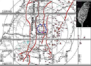
Figure 1 The location of the epicenter of Ji-Ji Earthquake(N23.85°,E 120.78°).The surface rupture extended 105 km from the west of the epicenter to the north of Ta-Chia River in TaiChung County.The major faults and after-shocks happened wilthin one month with magnitude greater than 4 in this area are also shown on the map.
Inventory of Landslides By Remote Sensing
Earthquake-triggered landslides were enumerated both by using SPOT images taken on 27 September and by aerial photographs taken in 7 days from 21 September to 27 September. Scars of land surface are depicted conspicuously on color aerial photographs as well as on color composite images because on the places of the landslides there are no vegetation and fresh rocks are exposed. Conventional manual approaches of interpretation are adopted with a modification of on-screen approach for directly obtaining a landslide dataset suitable for subsequent GIS processing. Aerial photographs in a scale of 1/17000 were digitally-scanned in 600 dpi for this purpose.
A total of more than 10 thousand landslides were observed on SPOT images within a week (Figure 2) and, on contrast, more than 20 thousand landslides were obtained by photo-interpretation using 1400 aerial photographs in one month.
(Coordinate system used in this study is a transverse Mercator projection with central meridian in longitude of E121 degrees and a swath from E120 to E123 degrees, covering the Taiwan Island.)
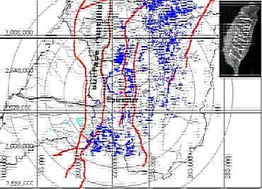
Figure 2 Landslides triggered by Ji-Ji Earthquake as interpreted from SPOT images taken within one week after the main shock.
Creeping-Type Landslide
Landslides with a small amount of surface creeping would give little clues on images and photographs, as shown in Figure 3. The place indicated by capital letter A shows no clear evidence of landslide. However, the field pictures (Figure 4) showed a disturbance of ground surface materials of the area. A close-look with scrutiny for the image with high resolution reveals a tensional linear cracks extending 1300m from point C to D. This indication gives a clue for further inspection of the photographs under stereoscope. The linear zone of the extensional crack shows clearly in the enlargement of the image. As depicted in Figure 5, roads along the crack zone were destroyed, this corresponding to a deformation zone in the field with more than 5 meters in width.
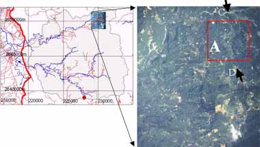
Figure 3 In a synoptic view of aerial photograph taken on 26 September 1999, landslides with exposed scars are conspicuous. However little clues can be found for a creeping type of landslide indicated at A.
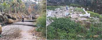
Figure 4 Field pictures show that the lands surface are disturbed by a creeping process in the area indicated at A in Figure 3. Though this is hardly can be clearly identified by aerial photo-interpretation.
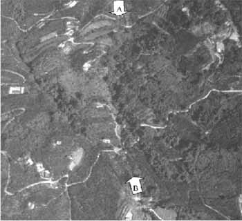
Fugure 5 An enlargement of the crack zone, the area is also indicted in the rectangle of Figure 3.
For a visualization of the change of this landslide, stereo-pairs both prior to and aft the event were also registered, rectified, and processed to obtain ortho-photos, contours, and DTMs (Figure 6). The sequence of the event is clearly exposed and the extent of the disturbed area of ground surface materials can be interpreted from the 3d images. The creeping-type landslide with an area of more than 100 hectares were thus observed. And, the existence of this creeping-type landslide was further proved by field observations (Figure 4).
Discussion and Conclusion
Generally speaking, earthquake-triggered landslides are easily enumerated by using satellite images or aerial photographs as the scars of land surface are depicted conspicuously on the places of the landslides, where there are no vegetation and fresh rocks are exposed. It is also possible to detect and identify creeping-type landslide by using aerial photographs especially when multi-temporal and high-resolution images are used for a close study on the characteristics of landform change.
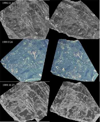
Figure 6 A sequence of the landform change prior to and aft the Ji-Ji Earthquake as simulated by merging orthophotos and DTMs of the Hon-Tsai-Ping study area.
References
- ERL (1999) Final Report on the investigation of landslides triggered by 921 Ji-Ji Earthquake and a general mitigation proposal. By Energy and Resources Laboratories, ITRI. 31 March 2000.