| GISdevelopment.net ---> AARS ---> ACRS 2000 ---> Poster Session 3 |
Earth Surface Geophysical
Parameters Determination From ATSR Data
Dr. Yong XUE and Huadong
GUO
Professors, Laboratory of Remote Sensing Information Sciences
Institute of Remote Sensing Applications
Chinese Academy of Sciences
No.3, Datun Road, Chaoyang District,
PO Box 9718, Beijing 100871, China
Tel: (86)-10-64889540 Fax: (86)-10-64889786
E-mail: y.xue@unl.ac.uk; guohd@irsa.irsa.ac.cn
CHINA
Professors, Laboratory of Remote Sensing Information Sciences
Institute of Remote Sensing Applications
Chinese Academy of Sciences
No.3, Datun Road, Chaoyang District,
PO Box 9718, Beijing 100871, China
Tel: (86)-10-64889540 Fax: (86)-10-64889786
E-mail: y.xue@unl.ac.uk; guohd@irsa.irsa.ac.cn
CHINA
Keywords: ATSR, Albedo, Temperature, Emissivity, Remote Sensing
Abstract:
The paper discusses determination of the Earth's geophysical parameters from ERS satellite Along-Track Scanning Radiometer (ATSR) data. This paper focuses on Earth's surface Albedo, temperature and emissivity. Land surface temperature (LST) and land surface emissivity retrieval by use of ATSR data was discussed in the paper. SST data is from Rutherford Appleton Lab, Oxford. In this paper, results of Earth's surface Albedo, Land surface temperature (LST) and land surface emissivity in UK and surrounding areas are presented. The ATSR SST data set has been shown to be useful in helping to estimate the geophysical parameters over the large space scale.
Introduction
Until very recently all Earth resource satellites have had near-nadir looking radiometers. However, off-nadir looking radiometers are now operating (SPOT, ATSR) and future scanning and pointable systems are being planned (AATSR). These systems have off-nadir and multiple view angle capabilities, which permit one to consider the intriguing possibility that off-nadir and multiple view angles, may provide a more accurate estimate of hemispherical reflectance than a nadir view angle only.
ERS-2 and ERS-1 carry onboard Along Track Scanning Radiometer (ATSR) which has a unique feature of viewing the Earth's surface from two different angles, i.e., 0° (nadir) and 55° (forward) and in multi-spectral mode. The dual angle and multi-spectral observations from ERS-1 ATSR has been shown to be useful not only affecting corrections for sea surface temperature but also in helping to estimate the moisture and temperature structure of the lower boundary (Mathur et al. 1993). Sea surface temperature (SST) retrieval from satellite IR observations is always perturbed by the attenuation of the IR signal reaching the satellite sensor due to water vapour along with CO2 and Ozone gases present in the intervening atmosphere. Therefore, the major efforts for retrieving the SST from satellite data is always concentrated towards a reasonable estimate of this perturbation. For the estimation of land surface temperatures the situation is quite different. Much less work has been done for land surface temperature (LST) than for sea surface temperature because LST is generally not homogeneous within a pixel and land surface emissivity may be quite different from unity and also dependent on the channel. There have been several attempts to achieve this goal under different conditions of the atmosphere (Xue and Cracknell 1996, Mutlow et al. 1994, Sobrino et al. 1993, 1994). In this paper, land surface temperature (LST) and land surface emissivity retrieval by use of ATSR data is discussed firstly.
The visible and near-infrared reflectances were derived from ERS-2 ATSR-2 spectral bands by using atmospheric radiative transfer model developed by Xue and Cracknell (1995). The narrow-band reflectances are combined into a measure of surface albedo by use of a weighted averaged scheme. The schemes were applied to the land and sea areas in UK.
Earth's Surface Temperature Determination From Satellite Data
For a cloudfree atmosphere under local thermodynamic equilibrium and a Lambertian Earth surface, the signal recorded in channel i of a satellite that observes the Earth's surface under a zenithal angle q can be written as follows:
Isat is the total radiance received by the sensor on the satellite, Isurf represents the contribution to the received radiance resulting from surface emission, Iatm represents the contribution to the received radiance resulting from the upwelling radiance emitted by the atmosphere towards the sensor and Irefl is the downward atmospheric radiance emitted by the atmosphere that is reflected upward at the Earth's surface and attenuated in its path to the sensor.
A multi-channel split-window equation has been obtained by the solutions of Equation (1) for two channels (i=11 and i=12, which are for the 11mm channel and the 12mm channel respectively). The basis of the double viewing angle method is to use two different absorption path lengths at one wavelength. A same multi-angle split-window equation also can be obtained by the solutions of Equation (1) for nadir- and forward-view. Following equation illustrates both situations:
where A0,q, A1,q and A2,q are the local split-window coefficients, which depend on the surface emissivity and the atmospheric state (Becker and Li 1990, Sobrino et al. 1991).
The formulae of multi-channel and multi-angle split-window should be chosen with caution. We used the formula from Becker and Li (1990) for nadir-view ATSR data. For two view angles at one wavelength Sobrino et al. (1993) was used. Based on above equation, We used
where
A110,q=1.274+273.15(1-A111,q-A112,q ) (5)
A111,q=b011+b111+a0+a1 +a2+b211)D eq11-(b111] +a1)(0.075e11+0.90) (6)
for 11mm channel and
A121,q=b012+b112+a0+a1+(a2+b212)D e q-(b112+a1)(0.075 e12+0.90) (9)
A120,q=1.274+273.15(1-A121,q-A122,q) (10)
for 12mm channel.Deq11 = e011 - eq11 and Deq12 = e012 - eq12.
The solution of the simultaneous equations (2), (3) and (7) gives the surface temperature (Ts) and the surface emissivities for the 11mm channel (e11) and for the 12mm channel (e12).
Earth Surface Albedo
The three main mechanisms by which the terrestrial atmosphere perturbs measurements of ground reflectance from space are as follows: (1) the aerosol and molecular backscattering changes the measured target reflectance, (2) for nonuniform sites the measurement is altered by the contribution of the target background and (3) the bidirectional properties of the target reflectance are partially smoothed out by the atmospheric scattering processes (Tanré et al. 1979). The study of these different atmospheric effects has been considerably developed (Fraser and Kaufman 1985, Kaufman 1982, Odell and Weinman 1975, Steven and Rollin 1986). Atmospheric models assuming the ground to be uniform and Lambertian have been studied extensively (Tanré et al. 1979).
The inference of surface spectral reflectance using visible observations is complicated mainly because of scattering effects, especially aerosol scattering effects. The aerosol optical thickness depends on aerosol characteristics (size distribution and refractive index) and on aerosol total loading. Ångström suggested a single formula for aerosol scattering optical thickness generally known as Ångström's turbidity formula given by the following: tAl=bl-a. In this formula, b is called Engstrim's turbidity coefficient, a is the wavelength exponent and l is the wavelength (Iqbal 1983). The problem arises of how to estimate the values of the parameters b and a.
A variety of techniques, the doubling or adding method, the successive orders of scattering, the iteration of the formal solution, the invariant imbedding method, the method of X and Y functions, the method of discrete ordinates, the spherical harmonics method, the method of expansion in eigenfunctions and the Monte Carlo method, have been developed for computing the intensity and polarisation of multiple-scattered light (Hansen and Travis 1974). The aim of the paper by Xue and Cracknell (1995) was to find an operational method which relies on multiple view angle observations or multiple solar zenith angle observations of the surface to accomplish part of this task in a routine manner. In the paper they attempted a solution to the problem of the retrieval of surface reflectance from satellite radiance measurements based on a solution of the radiative transfer equation introduced by Chandrasekhar (1960) and developed further by Kondratyev (1969). The problem defined for a horizontally stratified atmosphere is sufficient to cover most applications for light scattering in planetary atmospheres. The scattering was assumed to involve no change of frequency within the visible region.
From Xue and Cracknell (1995), spectral downcoming radiation flux and upgoing radiation flux can be calculated. At the Earth surface, tl = 0, which gives
for a downcoming global radiation flux and
for a upgoing global radiation flux. A is the surface albedo. The E0l is the solar spectral irradiance at the top of atmosphere, a = secq and b = 2; e is the backscattering coefficient, typically 0.1. The solar zenith angle is calculated from latitude, longitude and time and q' is the zenith angle of the sensor. The atmospheric optical depth (t0l) is determined by the turbidity state of the atmosphere. The details on how to derive the Albedo and reflectance from ATSR dual view visible band data can be found from Xue and Cracknell (1995).
Tests and Results
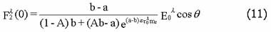
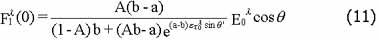
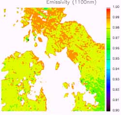
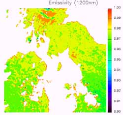
The date and time of the ATSR data were 2nd August 1995 and 11:00 GMT. The area is located in the middle of UK. In this area there are land and sea surfaces. The algorithms have been used to calculate reflectances and albedo from dual view ATSR visible band data. Figure 1 (a) shows the Earth's surface albedo. Figure 1 (b) gives Earth Surface temperature (LST and SST) in °K. Figures (c) and (d) show the land surface emissivity for 11mm and 12mm channels respectively. Cloudy areas (white plot) were not calculated.
The 1995 is the hottest year since first global temperature recording in 1860 from the Meterological Office, UK. The sunny and exceptionally hot weather which began at the end of July lasted through the first three days of August with the temperature exceeding 33°C (306 degK) daily at several places. August 1995 was, averaged over the whole United Kingdom, probably the hottest and sunniest on record, and one of the driest (Eden 1995). In Fig. 1(a), we can see that the temperatures in most areas are around 30°C. Some areas in Midland are higher than 36°C. The surface temperature determined from satellite data is the instantaneous effective surface temperature. The temperature from weather forecasting is the air temperature at 1 m height. The black plots are cloudy areas. From Fig. 1 (b) and (c), we can see that the emissivity is not very close to unity. The values of the emissivity is around 0.97 - 0.99 for the 11mm channel and 0.96 - 0.98 for the 12mm channel. This agrees with the result of Taylor (1979) that the surface in agricultural areas behaves almost like a black body (e = 0.97). It will be noticed that the emissivity for the 11mm channel is greater than for the 12mm channel.
Conclusions
An accurate determination of the surface properties is therefore essential to obtain the various terms of the energy budget: the reflected solar flux - knowledge of the emissivity and the temperature; the upward longwave flux - knowledge of the emissivity and the surface temperature; the heat and water fluxes are the turbulent sensible and latent heat fluxes, both depending on the surface temperature (Xue et al. 1998, 2000a, b).
The paper demonstrated that ATSR-2 data can be used to determine the Earth's surface Albedo, temperature and emissivity. The approaches are simple methods to remove the atmospheric effects from visible and thermal band data. For a non-Lambertian surface, the bidirectional properties of the ground surface should be taken into account. The narrow-band reflectances are combined into a measure of surface albedo by use of a weighted averaged scheme.
Acknowledgement
The author thanks Professor D. T. Llewellyn-Jones and the RAL, Oxford, for supplying the ATSR data.
References
- Chandrasekhar, S., 1960, Radiative Transfer (New York: Dover Publications).
- Eden, P. 1995, Hot, dry, and sunny - a record-breaking month. Weather Log, August, 1995.
- Hansen, J.E., and Travis, L.D., 1974, Light scattering in planetary atmospheres. Space Science Reviews, 16, 527-610.
- Iqbal, M., 1983, An Introduction to Solar Radiation (Toronto, Canada: Academic Press).
- Kondratyev, K. Ya, 1969, Radiation in the Atmosphere (New York: Academic Press).
- Mutlow, C. T., Zavody, A. M., Barton, I. J., and Llewellyn-Jones, D. T., 1994, Sea?surface temperature?measurements by the along?track scanning radiometer on the ERS?1 satellite ? early results. Journal of Geophysical Research?Oceans, 99, 22575?22588.
- Sobrino, J. A., Coll, C., and Caselles, V., 1991, Atmospheric correction for land surface temperature using NOAA-11 AVHRR channel 4 and 5. Remote Sensing of Environment, 38, 19-34.
- Sobrino, J. A., Li, Z. -L., Stoll, M. P., and Becker, F., 1993, Determination of the surface temperature from ATSR data. Proceedings of 25th International Symposium on Remote Sensing of Environment held in Graz, Austria, on 4th-8th April, 1993 (Ann Arbor, ERIM), pp II-19-II-109.
- Sobrino, J. A., Li, Z. -L., Stoll, M. P., and Becker, F., 1994, Improvements in the split-window technique for land surface temperature determination. IEEE Transactions on Geoscience and Remote Sensing, 32, 243-253.
- Tanré, D., Herman, M., Deschamps, P.Y., and De Leffe, A., 1979, Atmospheric modelling for space measurements of ground reflectances, including bidirectional properties. Applied Optics, 18, 3587-3594.
- Taylor, S. E., 1979, Measured emissivity of soil in the Southeast United States. Remote Sensing of Environment, 8, 359-364.
- Xue, Y., and Cracknell, A. P., 1995, Operational bi-angle approach to retrieve the Earth surface albedo from AVHRR data in the visible band. International Journal of Remote Sensing. 16, 417-429.
- Xue, Y. and Cracknell, A. P., 1996, The Earth's surface temperature. In The Determination of Geophysical Parameters from Space, edited by N. E. Fancey, I. D. Gardiner and R. A. Vaughan (Edinburgh: SUSSP Publications; London: IOP Publishing), pp. 209-240.
- Xue, Y., Lawrence, S. P., Llewellyn-Jones, D. T., and Mutlow, C. T., 1998, On the Earth's surface energy exchange determination from ERS satellite ATSR data: Part 1. Long-wave radiation. International Journal of Remote Sensing, Vol. 19, No. 13, pp2561-2583.
- Yong Xue, David T. Llewellyn-Jones, Sean P. Lawrence, and Mutlow, C. T., 2000, On the Earth's surface energy exchange determination from ERS satellite ATSR data: Part 2. Short-wave radiation. International Journal of Remote Sensing (In print).
- Yong Xue, David T. Llewellyn-Jones, Sean P. Lawrence, and Mutlow, C. T., 2000, On the Earth's surface energy exchange determination from ERS satellite ATSR data: Part 3. Turbulence heat flux of open sea. International Journal of Remote Sensing (In print).
 |
 |
| (a) | (b) |
 |
 |
| (a) | (b) |
| Figure 1 Geophysical parameters derived from ATSR data in UK and surrounding area. The date and time of the ATSR data were 2nd August 1995 and 11:00 GMT. The unit for Land Surface Temperature (LST) and Sea Surface Temperature (SST) is °K. | |