| GISdevelopment.net ---> AARS ---> ACRS 2000 ---> Poster Session 3 |
Drought Monitoring in Zambia
using Meteosat and Noaa Avhrr Data
Kawana Nawa
Remote Sensing Unit
Zambia Meteorological Department,
P.O. Box 30200, Lusaka, Zambia
Fax/Phone: (260-1) 252728/251889,
E-mail: knawa@yahoo.com
Keywords : Satellite rainfall estimates,
Rainfall deficits, Meteosat, NOAA. Remote Sensing Unit
Zambia Meteorological Department,
P.O. Box 30200, Lusaka, Zambia
Fax/Phone: (260-1) 252728/251889,
E-mail: knawa@yahoo.com
Abstract
Rainfall is of crucial importance for all life in Zambia not only because it is a resource for human and livestock but also because it is the major limiting factor to plant growth. Between 80 to 90% of agriculture in Zambia is rain-fed and as a result, any falls in the required amounts need to be identified as quickly as possible to enable decision makers take necessary measures to avoid catastrophe in human, plant and animal life. Rainfall in Zambia is highly irregular in space and time which makes cultivation difficult since small differences in the amounts and timing of rain received at a site may determine the success or failure of critical stages in Vegetation development and hence crop production. Determination of areas of rainfall deficit can be greatly improved by using satellite rainfall estimates.
Rainfall measurements have traditionally come from a network of raingauges which in the past years have dwindled in number. Since raingauge measurements are only valid for a small area in the immediate vicinity of the instrument, use of Geo-stationary satellites such as the Meteosat and polar orbiting satellites such as the NOAA series, provide data at a resolution sufficient for monitoring of rainfall events at a much wider scale. Currently different rainfall information is produced and disseminated to various users ranging from farmers, researchers to decision makers.
Introduction
Throughout much of Africa, rainfall is the most important meteorological factor in determining agricultural production and hence economic well being on a local or national scale. Accurate, real-time information on rainfall should therefore be valuable in providing an overview of the development of the current rainy season, and highlighting areas where drought or crop shortfalls are likely. Unfortunately, the raingauge network in Zambia is too sparse to provide this overview and is still reducing further as government funding on public services continues to be small.
The use of rainfall estimates based on satellite data should be of great benefit. In particular, Meteosat thermal infrared imagery can be used in detecting CCD's (an indicator of convective cloud activity) at different thresholds. The CCD images are used in a number of algorithms to give useful quantitative rainfall estimates. These estimates can easily be produced in near real-time and give full area coverage irrespective of the remoteness of a region given the temperal and spatial characteristics of the Meteosat satellite. Complementary information on vegetation and seasonal large scale flooding can be derived from NOAA-AVHRR satellite.
The problem remains of how to communicate this information to local institutions that need to use it. We argue in favour of local reception facilities - they provide more timely information, ensure local staff are familiar with remote sensing technology, improves their scientific background, promotes technical independence of local institutions and can provide information not usually available from international dissemination centres. Locally produced information has a better chance of reaching a wider local user base and is more flexible to varying user demands.
Aiming at improving this situation a joint project took place between the TAMSAT group, Department of Meteorology at the University of Reading, UK and the Zambian Meteorological Department (ZMD). Zambia was suitable for simple rainfall estimation algorithms based on Meteosat Thermal Infra-Red (TIR) imagery and ZMD had the basic technical capacity (Meteosat and NOAA-AVHRR receivers) already in place.
The Aims of the Project were:
- To refine rainfall related information from station and satellite data.
- To implement an operational system of dissemination of agro-meteorological information to a user community along the principles of sustainability and independence. Such a system was designated ZAMIS (Zambian AgroMeteorological
ZAMIS Design : The design of the ZAMIS obeyed the following requirements:
- that it should be adaptable to take account of changing user requirements;
- that the hardware and software used should be inexpensive and easily maintained
- that the staff involved should understand the limitations and benefits of the methodologies
- that the staff involved should be capable of developing new output products as appropriate
System Outputs : From an input consisting of sets of dekadal raingauge data, daily and dekadal images of storm cloud duration (CCD), plus NOAA-AVHRR day time and night time imagery, the system is able to produce a set of outputs such as:
Ten day rainfall estimates: These are derived from a weighted average of gauge and satellite data (Grimes et al, 1999): A set of gauge rainfall values is interpolated by block kriging thus deriving a map of rainfall and a map of the associated uncertainty (error variance). A regression model provides an estimate of rainfall and associated error from an image of CCD output by a Meteosat. A combined estimate is derived as a weighted average of the two above estimates. The weights are a function of the uncertainty in each component - where the gauge network is sparse, the gauge derived estimate has higher error and hence smaller weight than the satellite estimate. The combined estimate therefore is weighted more heavily by whatever component is locally more accurate.
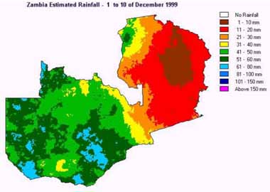
Figure 1 Rainfall Estimate for dekad 1, December 1999
Number of rain days in dekad: Although the amount of rainfall from Satellite Estimates is less reliable on a daily time step as compared to decadal, it can provide useful information on the probability of rainfall having occurred.
A logistic model was derived relating probability of rainfall above 0 to amount of daily CCD, calibrated on years of historical data. This model derives an image of probability of rainfall from an image of daily CCD. From the images of probability of rainfall we derive categorical images of rainfall occurrence by thresholding at a given probability level, i.e. set pixels to 1 if above this threshold, set to 0 if below. The threshold is derived according to criteria of optimal discrimination of rain/no-rain.
From these daily rainfall occurrence images we can trivially derive images of number of rain days per dekad or month. The quality of estimates of consecutive dry periods is under investigation.
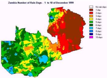
Figure 2 Number of Rain Days in dekad 1, December 1999
Sowing rains occurrence: These are derived from the above as areas where it rains more than 25mm from 4 or more rain days in a dekad (ZMD internal definition). These are used to monitor the onset of the growing season and produced up to end of December
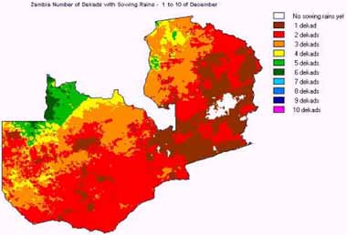
Figure 3 No. of Dekads with Sowing Rains, dekad 1 December 1999
Cumulative rainfall: Derived from the ten day rainfall images.
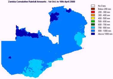
Figure 4 Cumulative Rainfall from 1st October 1999 to April 10, 2000
Cumulative Rainfall Departure: Derived from the rainfall images and climatological rainfall images.
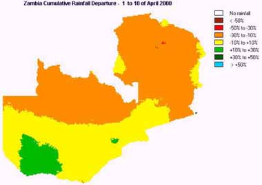
Figure 5 Cumulative Rainfall Departure from normal 1 to 10th April, 2000
Vegetation index, NDVI: Derived from the NOAA data by the usual combination of NIR and Red reflectances. These are produced consistently with the rainfall outputs (same window, resolution)
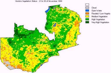
Figure 6 Zambia Vegetation Status 21- 30th November 1999
Users: The users of our information range from Government Institutions (like Disaster Management Unit, Ministry of Agriculture, Department of Water Affairs e.t.c), International Organisations like FEWS, farming community, researchers from local and International Universities, Non Governmental Organisations, Zambia Electricity Supply Company, Regional Organisations involved with management of regional water bodies like Zambezi River Authority.
This information has been well received by users who have used it in various ways like agriculture, water management, research, disaster management e.t.c. Most of the users have been very active and have helped in refining our products by giving us feed back and suggestions on how best to improve our information to suit their needs. One particular example is one in which a non-governmental organisation (Program Against Malnutrition) asked for rainfall data normally represented at a national scale broken down to administrative districts. This suggestion was incorporated into our dekadal tasks and the product has proved more helpful to the NGO whose work is mainly at district level. Another example was one in which FEWS asked for Excel plots of point extracted values from a cumulative rainfall image against the normal. This helps them in verifying independent field reports.
Validation: National Early Warning Cards are usually sent to Meteorological and part time Rainfall reporting Stations. At the end of every dekad, fully completed cards are then sent back to us containing all the rainfall amounts for that dekad and comments on agriculture performance. We then use the rainfall reports to improve the accuracy of Rainfall Estimates and the Agriculture performance reports to independently validate data that we produce.
Dissemination: Given widespread access to e-mail the maps (JPEG) derived from the system are sent as e-bulletins (Word files) via e-mail. Web versions are prepared and we hope to have them available soon. All data is produced in a regular lat-long grid (20 pixels/degree) covering most of the Zambezi Catchment.
Training: The installation of the AMIS was accompanied by an extensive training program. Given the need for sustainability it was crucial for the operators to be fully familiar with the background, the methodologies and the software the system had been implemented in. Depending on the initial status of the staff, training also included basic programming principles and algorithms. The choices made for software (IDRISI+AWK) provided a very shallow learning curve allowing the operators to quickly build up significant amounts of work and a good confidence level.
Conclusion: The temporal and spatial resolution of satellite derived information has practically proven in this particular case to be more handy and timely to decision makers to make well informed decisions on time. A steady stream of quality data has been accumulating and we hope to benefit in future from improved calibrations and refinement in the interpretation of NOAA-AVHRR data. We hope in particular to start the usage of the produced rainfall and vegetation related data in applications such as rainfall-runoff models for flood warning and river management. We have been archiving data and would like to invite other institutions to participate in cooperative applied research ventures.
References
- Grimes, D.G., E. Pardo and R. Bonifácio, 1999, Optimal Areal Rainfall Estimation using raingauges and satellite data, Journal of Hydrology, 222, 93-108,
- Nawa.,K 2000, Drought Monitoring in Zambia using Meteosat and AVHRR Data.