| GISdevelopment.net ---> AARS ---> ACRS 2000 ---> Poster Session 3 |
Approach to Land-use Analysis
in Hetao Irrigation Project of Inner Mongolia, China, Based on Satellite
Image Data
Takashi KUME, Kiyoshi TORII
and Toru MITSUNO
Graduate School of Agriculture
Kyoto University Oiwakecho, Kitashirakawa, Sakyoku, Kyoto
Tel. & Fax.: (81)-75-753-6459
E-mail: zak@kais.kyoto-u.ac.jp
JAPAN
Keywords : Land use analysis, Inner Mongolia
irrigation projectGraduate School of Agriculture
Kyoto University
Tel. & Fax.: (81)-75-753-6459
E-mail: zak@kais.kyoto-u.ac.jp
JAPAN
Abstract
Hetao irrigation district is a large-scale irrigation area, which takes 294,000,000 m3 of water annually (just less than 300 m/sec) from the Yellow River and covers 500,000 ha of agricultural field with. While this area has the history of irrigated agriculture since the time before Christ, a full-scale irrigation product was started about 100 years ago. At present, the project is said to be in a critical situation due to serious problems of water shortage and saline soil in addition to decrepitude of irrigation facilities.
In the present study, we analyzed land-use changes in the respective irrigation blocks in recent years using satellite image data to grasp the actual state of irrigation in this big project and to find a clue for solving problems in future. We present outline of the results.
Intorduction
Land-use analysis in a large-scale irrigation area is a very useful method for cropping, improvement in agricultural production, environmental assessment and irrigation-drainage planning.
Irrigation-drainage system is indispensable in arid and semi-arid areas such as Hetao irrigation district (Fig. 1) selected in this study. Agriculture without irrigation is not effected in arid and semi-arid areas where evapo-transpiration exceeds precipitation. However, inappropriate irrigation has caused soil salinization problem all over the world and this is one of the serious problems to be solved as quickly as possible. Hetao irrigation district is no exception in this aspect and the soil salinization problem is also found in this area. To solve the problem, the areas with soil salinization must be specified. However, specification of the areas with soil salinization consumes much labor, time and cost in large-scale irrigation areas such as Hetao. Thus, utilization of satellite image data, which offer monitoring in extensive areas and time-series analysis, becomes very effective.
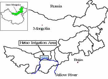
Fig. 1 Inner Mongolia
The study area where we attempted land-use analysis based on satellite image data is Linhe City. We performed supervised classification (the most-likely classification method) and unsupervised classification to identify dunes and salinized areas in this district.
Soil salinization in arid and semi-arid areas is likely to result in desertification in future. In Hetao irrigation district in particular, Wuliangpuhe Desert is approaching from the west and continuation of irrigated agriculture in this area will consequently prevent desertification of Inner Mongolia. In this study, we attempted to grasp the situation in the salinized areas spreading around the irrigation district.
Study Area
Hetao irrigation district (Fig. 2) is located in Yellow River basin, Inner Mongolia, China, and it is 250 km in width from east to west and 50 km in length from north to south and its altitude is between 1019 and 1050 m. It has the east-to-west inclination between 1/5000 and 1/8000 and the north-to-south inclination between 1/4000 and 1/8000. It has the area of about 1,100,000 ha including 514,000 ha of agricultural area and 482,000 ha of the agricultural area corresponding to 93% are irrigated by Yellow River. Agriculture is impossible in this area without irrigation water from Yellow River. The annual precipitation in this area is between 130 and 200 mm increasing from west to east and the annual evapo-transpiration is between 2000 and 2400 mm. The highest temperature in summer is 38 °C and the lowest temperature in winter is -38 °C.
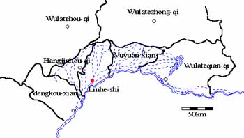
Fig. 2 Hetao rrigation district
Irrigation in this area has a long history since the time before Christ. In 1900, eight large irrigation canals were completed and the irrigation area from Yellow River became around 700,000 ha. After 1901, the Ching dynasty continued to expand irrigation area. Since the founding of People's Republic of China in 1949, Hetao irrigation district was improved rapidly. The Yellow River embankment was completed in 1950 and the irrigation area was expanded to 270,000 ha with construction of release sluice.
The irrigation area continued to expand subsequently reaching 480,000 ha in 1975. However, with expansion in the irrigated area, soil salinization in Hetao irrigation district has become a serious problem coupled with long-standing irrigation and various problems. In 1997, flow in Yellow River was cut from the river mouth to the point 700 km upstream raising a problem of water shortage. In Hetao irrigation district, salt accumulation is detected in 476,000 ha corresponding to 50% of the irrigated land of 1,100,000 ha. While salt once accumulated cannot be eliminated unless it is leached by a large amount of precipitation or irrigation water, the annual rainfall in Hetao irrigation district is extremely small as 180 to 200 mm as mentioned previously and, together with the water shortage in Yellow River, there is not sufficient water for leaching.
In this difficult situation, Hetao irrigation district has tasks of crop production with economized irrigation and rehabilitation of salinized ground. We examined distribution of dunes and salinized areas by the land-use analysis using remote sensing image data as the first step to solve these problems.
Materials and Method
As satellite image data, Landsat TM data (spatial resolution: 30m x 30m, path-row: 129-32 , date of observation: 1989/9/17) were used.
The result of image classification was used to analyze land uses in Hetao irrigation district according to the following procedure.
- All satellite image data were geometrically corrected based on the GCP obtained by the field survey (2000/8/11, 12) using the analysis software.
- Subset image around Linhe City was extracted referring to Inner Mongolia Maps (published by Inner Mongolia Map Pub.).
- Supervised and unsupervised classifications were performed with five training classes of water, dune, urban area, vegetation and saline soil (including naked ground).
- From the results of classification, areas were calculated and compared with the results of the field survey.
| Parametric Decision Rule | Non-Parametric Decision Rule | Other Decision Rule | |
| Supervised classification 1 | Maximum Likelihood | Multi Level Slice | × |
| Supervised classification 2 | Maximum Likelihood | × | × |
| Unsupervised classification | × | × | ISODATA Method |
 |
 |
| Fig.3 Signatures in Linhe | Fig4 Reflection characteristics(CCT value) |
In the supervised classification 1, parametric most-likely classification method was employed for unclassified areas following the nonparametric classification. In the supervised classification 2, only parametric most-likely classification was performed. For unsupervised classification, ISODATA method was used.
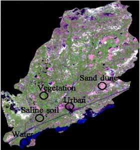
Fig. 3 shows the areas extracted as training data for dune, salinized soil (including naked soil), vegetation, water and urban area based on the satellite image of the area. All the areas underwent ground-truth in the present survey.
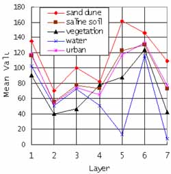
Fig. 4 shows the mean spectral reflection characteristics of the respective bands in the training area.
Results and Discussion
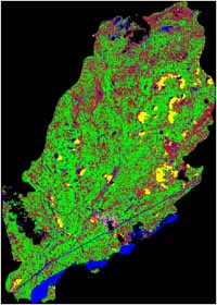
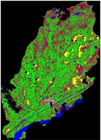
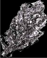
Figs. 5 to 7 show the results of the supervised classifications 1 and 2 and unsupervised classification mentioned previously. Table 2 shows the areas (ha) of the respective classes in the results of classification in Figs. 5 to 7. Here, we discuss the most-likely classification method applied generally. In the area of about 247,000 ha in Linhe, 8,556 ha (3.46%) were classified into dune and 96,532 ha (39.1%) were classified into the saline soil; the area amounting to 42.56% is the land of dunes and saline soils not covered with vegetation.
 |
 |
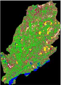 |
| Fig5 Supervised classisification1 | Fig6 Supervised classisification2 | Fig7 Unsupervised classification |
Table2 Result of classification
| Method | Sand dune | Saline soil | Vegetation | Water | Urban | Others | Total |
| (ha) | (ha) | (ha) | (ha) | (ha) | (ha) | (ha) | |
| Supervised classification 1 | 8556 | 96532 | 111967 | 13763 | 3009 | 13135 | 246963 |
| Supervised classification 2 | 7218 | 97158 | 111884 | 13600 | 3642 | 13460 | 246963 |
| Unsupervised classification | 14458 | 92745 | 98986 | 8135 | 26602 | 6037 | 246963 |
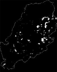
Figs. 8 and 9 show the areas coinciding to both the result of extraction of dunes and the result of extraction of dunes and saline soils (including naked soils) from Figs. 5 and 6. Table 3 shows the results. Comparison of Tables 2 and 3 reveals decreases in dunes and saline soils. These are the results of extracting the areas common to Figs. 5 and 6.
While the result of classification of saline soil is considered to include large areas of naked land, a diagram of naked land = saline soil is true in many areas in Hetao irrigation district and detailed classification is difficult. Moreover, as our analysis utilizes the block where a part of dunes, saline soils and houses are made of alluvial soil distributed in the whole Hetao irrigation district, it is very difficult to classify them in detail.
| Method | Sand dune | Saline soil | Vegetation | Water | Urban | Others | Total |
| (ha) | (ha) | (ha) | (ha) | (ha) | (ha) | (ha) | |
| Supervised classification 1 | 8556 | 96532 | 111967 | 13763 | 3009 | 13135 | 246963 |
| Supervised classification 2 | 7218 | 97158 | 111884 | 13600 | 3642 | 13460 | 246963 |
| Unsupervised classification | 14458 | 92745 | 98986 | 8135 | 26602 | 6037 | 246963 |
 |
 |
| Fig8 Extracted image of sand dune | Fig9 Extracted image of sand
dune and saline soil |
Table3 Result of after extract
| Sand dune (ha) | Sand dune (%) | Saline soil (ha) | Saline soil (%) |
| 7211 | 2.9 | 93056 | 37.7 |
It is seen from Fig. 9 that soil salinization in Hetao irrigation district tended to increase from the south with the main canal (irrigation) to the north with the main drainage canal. In Linhe City, three irrigation canals (Yongji canal, Gangji canal, Fengji canal) out of eight big canals were constructed already in 1900 and inappropriate irrigation at that time was considered to accelerate soil salinization resulting in presence of numerous dunes in comparison to the vicinity of Linhe.
Conclusion
Following results were obtained by the analysis.
- It was necessary to combine the result of detailed ground truth in analysis for accurate classification of saline soil and naked soil.
- It would be possible to grasp land cover changes in dunes and saline soils accurately by performing time-series analysis of satellite images in various seasons by supervised classification.
Acknowledgement
In ending the paper, we would like to express our deep gratitude to Inner Mongolia Scientific Technology Association, Inner Mongolia Agricultural College and Hetao Irrigation District Authority for their cooperation in survey and field trip, Professor emeritus Kinzo Nagahori of Okayama University, Professor Takao Amaya of Gifu University and Professor Takeo Akae of Okayama University for their useful advice and NASDA, RESTEC in Japan and EROS Data Center in USA for satellite image data supply. The survey in Hetao Irrigation District was supported by Scientific Research Fund for Basic Researches (A)(1) of Ministry of Education (Project No. 11306015, represented by Kiyoshi Torii).
References
- Wang, lun, ping. , Study on Irrigation-Drainage system and prevention of Alkali-saline soil in Hetao irrigation area, Inner Mongolia.
- T. Amaya, Study on agriculture and livestock farming productivity based on grassland soil in Inner Mongolia, China: Bulletin of Agriculture, Gifu University No.61
- K. Nagahori, Study on development of alkali-saline soil in Hetao irrigation area, Inner Mongolia, China: Bulletin of Environmental Scie. & Tech, Okayama University
- T. Akae, Study on irrigation agriculture and saline accumulation problem in Hetao irrigation area, Inner Mongolia, China: Bulletin of Environmental Scie. & Tech., Okayama University
- T. Kume, Study on development of saline soil and Irrigation-Drainage system in Hetao irrigation area: 1999, Master Thesis, Gifu University
- ERDAS FIELD GUIDE, ERDAS Inc., pp.213-258