| GISdevelopment.net ---> AARS ---> ACRS 2000 ---> Poster Session 3 |
Application of optical remote
sensing technology for oil palm management
Ibrahim.S , Zainal Abidin
Hasan & Mariamni Khalid
AbstractRecent advances in remote sensing technology and applications, with concurrent advances in global positioning systems (GPS) and the ubiquitous use of geographic information systems (GIS), have provided a powerful analysis tool for precision agriculture. These advances have also led to intense informational requirements. Image-based remote sensing may provide the timely, spatially distributed information on crop and soil conditions that is needed to implement precision agriculture. The aim of this paper is to investigate the relationship between Landsat Thematic Mapper (TM) relative radiance and phenology of oil palm for commercial estates in Selangor, Malaysia. This study focused on estimating oil palm phenology with special emphasis to planting age (1- >20 years) and Leaf Area Index (LAI) to spectral radiance via multiple linear regression models. The carrier (predictor) variables that was considered for multiple regression are the six Landsat TM bands, Shadow Canopy Index (SI), Bare Soil Index (BIO), Normalised Vegetation index (NDVI), Advanced Vegetation Index (AVI), planting densities, soil units and relief. The relative radiance recorded by Landsat TM for oil palm was negatively correlated with stand age. Middle Infrared wavebands (MIR) band 7 and 5 showed high correlation (> 0.74) and more discriminating power (Lambda Wilk's coefficient) to discriminate the oil palm age classes. However, the visible and Near Infrared bands displayed insignificant correlation (< -0.05). Nevertheless, it is concluded that the developed regression model was able to produce reasonably accurate oil palm age classes at estate level from satellite image.
Introduction
Oil palm has become an important crop in Malaysia. The country is the world's largest exporter of palm oil. Within a relatively short period the planted areas under oil palm have increased tremendously from 54,656 hectares in 1960 to 300,800 hectares in 1970 and 1.98 million hectares in 1990. In 1993, the total area under oil palm was estimated to be 2.2 million hectares (Primary Industries Department of Malaysia, 1998). Oil palm cultivation in Malaysia is largely based on the estate management system and organised smallholders under The Federal Land Development Authority (FELDA), Federal Land Consolidation and Rehabilitation Authority (FELCRA), The Rubber Industry Smallholders Development Authority (RISDA) and the State Economic Development Corporation (SEDCs). This has enabled a better utilisation of resources as well as the application of advanced management and planning techniques throughout most of the industry.
Because of the importance of oil palm to the country, accurate and reliable information is needed for oil palm management, especially on plant quality, phenology, health and yield prediction. However, in the context of Malaysia, lack of data, cost effective and timely processing of information for oil palm management planning are major constraints which hold up decision making. Currently data collection for oil palm planning and management depend mainly on traditional methods of sample surveys in the field. The main task of Malaysian agriculture agencies is to improve the reliability, timeliness and cost effectiveness of data collection techniques. Remote sensing was identified as an effective recent agricultural crop information for the global oil palm plantation industry planning (MACRES, 1998).
In Malaysia, the usefulness of remote sensing in crop management has not been intensively explored. Remote sensing in conjunction with a land information system is believed to be a good technique to assist the Malaysian Agriculture Planning Unit and estate managers in making fast decisions. Therefore, based on the importance of oil palm to the country and the lack of reliable, timely and cost effective data, a study of application of satellite images to plantation information management and planning is justified. The aim of this paper is to elaborate the relationship between Landsat TM radiance and the phenology of oil palm on commercial estates in Selangor, Malaysia (Tuan Mee and Balau Estate), especially the ability to characterise age since field planting and to acquire knowledge on producing oil palm vigour map from remote sensing.
Methodology
Study area
Balau and Tuan Mee estates are situated at Semenyih and Kuala Selangor, respectively, in the state of Selangor, Malaysia They were selected as study areas because of the availability of the ground-surveyed data supplied by Applied Agriculture Research Sendirian Berhad (AARSB), the agriculture adviser to both estates. Balau Estate is relatively flat with less than 17 degree slope whereas Tuan Mee Estate is undulating with 10 to 20 degree slopes.
Landsat imagery
The Landsat TM scene used was path 127 row 58 for 6 March 1996, bands 1,2,3,4,5 and 7, pre-processed by the ground station to level 4 (radiometrically corrected and across track geometric correction applied) (Figure 3.2 and Figure 3.3). The imagery was supplied by the Malaysian Centre for Remote Sensing (MACRES) who acquired it from Thailand's ground receiving station. The Landsat TM imagery was atmospherically adjusted using the dark-pixel subtraction method (Foody, 1997). Dark object subtraction methods are based on the assumption that within an image some pixels will lie in areas of complete shadow and so any radiance measured from them by the sensor must be attributable to the atmosphere requisite that image has been radiometrically calibrated.
Pixel sampling
A simple stratified sampling scheme (Gallego, 1995) with strata based on oil palm age was used to extract the Landsat TM spectral radiance values. A sample of 373 and 757 pixels, each 30 X 30 m were distributed randomly were selected from Balau and Tuan Mee Estate, respectively. Samples were selected based on visual interpretation of the Landsat-5 image, the topographic map, and oil palm years planting map. A number of considerations were taken into account during the sampling procedure: 1: The location of training areas near the boundary of different planting stages was avoided. 2: Extreme care was taken to prevent the selection of training areas within or near to shadow areas.
Discriminant Analysis of Landsat TM Spectral Radiance on Oil Palm Plantation
The relative strength of the relationship between oil palm age classes and the radiance data acquired from Landsat TM bands were examined. The Wilks's Lambda coefficients (Johnston 1978, Klecka 1980, and Boyd et. al. 1996) adopted from discriminant analysis in SPPS were used to analyse the relative importance of six Landsat TM bands as discriminating variables. The magnitude of the Lambda coefficient is inversely related to the ability of wavebands to discriminate between classes (Boyd et. al. 1996). Table 3.1 shows the rank order of the six individuals Landsat TM bands according to discriminant analysis. It illustrates that the data acquired by band 5 and band 7 (middle infrared, MIR) of both the study sites showed a considerably more discriminating powers, with band 7 providing the highest.
| Lands at TM | Wilks's Lambda (a) | Correlation ( rs ) | Wilks's Lambda (b) | Correlation ( rs ) |
| TM1 | 0.665 | -0.71683 | 0.856 | 0.9857 |
| TM2 | 0.381 | -0.70300 | 0.806 | -0.01492 |
| TM3 | 0.371 | -0.65986 | 0.809 | -0.14758 |
| TM4 | 0.864 | -0.50710 | 0.772 | -0.06242 |
| TM5 | 0.283 | -0.79930 | 0.459 | -0.84384 |
| TM7 | 0.273 | -0.73718 | 0.383 | -0.65027 |
Table 3.1: Discriminant analysis for TM bands and age classes for Tuan Mee Estate (a) and Balau Estate (b). Spearman rank correlation coefficients (p <0.05) between radiance and age is also shown
(source: ibrahim, 2000)
The Spearman rank correlation coefficient (rs) of each Landsat TM bands was calculated. The visible and near infra red bands displayed insignificant correlation (p < 0.05). The relationships obtained from the data acquired in MIR bands were stronger and statistically more significant than those achieved in the visible (band1, band 2 and band 3) and near infrared band (NIR) (band 4). The highest correlation coefficients between oil palm age classes and TM radiance were obtained from TM7 and TM5 [(rs = -0.737 and -0.799 (Tuan Mee), rs = -0.650 and -0.844 (Balau Estate)], respectively which were significant at the 99% confidence level. A study by Boyd et. al. (1996) also found that Landsat TM band 5 and 7 showed higher Spearman rank correlation coefficient and better power to discriminate tropical regenerative stages in even-aged forest. The effects of interrelated factors such as scattering within leaves, canopy shadow, chlorophyll absorption, canopy transpiration and under storey reflectance (McWilliam et al. 1993) can be used to explain the relationships resulting from data acquired in respective TM Wavebands and oil palm age classes. However, the influence of each factor may be changed due to the canopy development of oil palm. Other factors that influence the relationship may be oil palm management practices in pruning, harvesting, fertilising and weeding of the respective study areas. TM bands had higher discrimation power and Spearman rank correlation coefficients between oil palm age and Landsat TM wavebands for Tuan Mee than Balau Estate. The result will be discussed in section 3.3.
The information provided by MIR bands 7 and 5 can be used effectively by incorporating other image processing techniques such as Advanced Vegetation Indices (AVI), Bare Soil Indices (BIO) and Shadow Indices (SI). The combination of the information provided by data acquired in the Landsat TM bands and its indices it is believed can strengthen the correlations obtained between the remotely sensed image and oil palm age classes and properties.
The study also illustrates that, of the indices, the Soil Index had the strongest Spearman rank correlation coefficients over the whole 1-26 or 4-21 year age range at 99% confidence level (rs = -0.78 and -0.82 for Tuan Mee and Balau estate, respectively). Other indices such as NDVI and the Advanced Vegetation Index had insignificant correlations and an inability to discriminate between age classes (rs = 0.47 and -0.05 for Tuan Mee Estate and rs = 0.13 and -0.01 for Balau Estate). However, the Spearman rank correlation coefficient for the Shadow Index (SI) was strong at Tuan Mee (rs = 0.70) and weak for Balau (rs = 0.02).
Spectral response and the development of oil palm canopy
A decrease in relative radiance with stand age was identified in all Landsat TM bands (table 3.1). McMorrow (1995) found the same trend for Landsat TM spectral response of oil palm stand age classes in Sabah Malaysia, and that oil palm spectral response was most age-sensitive for stands less than 5 years old. In this study, oil palm spectral radiance was also most age-sensitive for younger stands, between 1 to 4 years old (figure 3.1). The higher discriminatory power and significant correlation at Tuan Mee relative to Balau Estate is explained by the fact that in the age range was 4 to 21 years old, whereas at Tuan Mee Estate it is between 1 to 26 years old, so Balau estate excludes the young stands that have the stronger correlation between age and radiance.
The factors explaining the spectral response of vegetation are numerous. They include interaction of radiation with the plant canopy, under storey plant effects, attenuation coefficient for radiation in the canopy and it's underlying soil background (Price and Bausch 1995). Corley (1973) explained that oil palm canopy closure starts at 4 years old and canopies reach a constant size by 9 to10 years old. The percentage of incident light intensity below canopy is a function of LAI: Log I = -0.44 L
where I is light intensity below the canopy and L is leaf area index (Corley 1973). Light intensity below the canopy is important because although the leaf area will be constant by 9 to 10 years old, by 20 years old the change of leaflets horizontal angle increases from 20 degrees to probably 40 to 60 degrees (Corley, 1973). The leaflets angle becoming less horizontal and more vertical and thus it mean that the canopy gap fraction is greater and so the ground cover contributes more.
The magnitude of the contribution of the canopy and soil are indicated in figure 3.3. Based on the contribution of the canopy and soil to the relative Landsat TM radiance, 6 types of oil palm plantation spectral response were identified: (1). One year old after planting, (2). 2 years old after planting, (3). 3 years old after planting, (4). 4 to 8 years after planting, (5). 9 to 19 years old after planting and (6). More than 20 years old after planting. The factors operating at each stage are:
- At 1 to 3 years old, the oil palm canopy LAI development increases rapidly and at the same time the contribution of soil and under layer vegetation decrease, i.e. as crown diameter increases.
- The LAI expands gradually until 8 years old.
- The LAI reaches a constant at 9 to 10 years old, depending on the genotype and oil palm management practices. The contribution of oil palm canopy, soil and under-storey vegetation is believed to be equal at 9 to 19 years old.
- The leaflet angles are believed to increase up to 60° (starting at 20 years old) and allow more light penetration to under-storey vegetation and soil.
- After 21 years old, the under-storey vegetation is believed to increase rapidly and at the same time the soil effect reduces until constant under-storey vegetation was achieved depending on oil palm plantation management practices
Conclusions
This study has investigated the usefulness of remote sensing for estimating oil palm age and leaf area index (LAI) using Landsat TM data and its indices in the Malaysian oil palm plantation system. The following summaries can be made from this study:
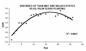
Figure3.1: The magnitude of the contribution of the oil palm canopy and soil
- Middle Infrared (MIR) wavebands of Landsat TM (band 5 and 7) for both estates contained considerable discriminating power and provide stronger relationships with oil palm age classes than data acquired in visible and near infrared wavebands. Similarly, it was found that the inclusion of MIR wavebands in multiple linear regression model 1 improves statistical significance. When all Landsat TM wavebands were included in the multiple regression analysis, band 5, 7 and 1 (Balau Estate ) and band 5, 4, 3, 1 and 7 (Tuan Mee Estate) were found to be statistically significant as predictor variables for oil palm age class estimation.
- Balau Estate had less relative error in oil palm age estimates in all models (model 1, 2 and 3) than Tuan Mee Estate. The regression analysis of oil palm age classes of Tuan Mee Estate needed more predictor variables compared to Balau Estate. This is believed to be due to the wide range of oil palm planting density and the terrain complexity of Tuan Mee Estate.
- Although the main aim of this study is to estimate oil palm age classes from spectral Landsat TM wavebands it was found that spectral indices could better discriminate oil palm age classes. Multiple regression models including indices SI, BIO and AVI with Landsat TM bands produced less error in age estimates at Tuan Mee.. They are recommended for plantations with similar complex terrain and a wide range of planting densities.
- Landsat TM bands and its indices in conjunction with GIS information can provide a reasonably accurate estimation of oil palm age at estate level. The planting density predictor variable improved the error of oil palm age estimation for both estates. Planting density can influence canopy development and, especially the age at which the oil palm canopy starts to close. Higher planting density causes canopy closure at an earlier age so that the regression line (constant) suggested should be steeper. The planting density variable should be investigated by developing separate regression models for low and high density blocks.
- The approach developed in the present study agrees with the view that the all features of the biosphere cannot be measured directly from satellite data. However by using an underlying functional relationship between variable under investigation and secondary variable that can be measured by satellite sensor, a model can be developed that predicts the desired information.
- BOYD D.S., FOODY D.S, CURRAN P.J., LUCAS R.M. HONZAK M. (1996) An assessment of radiance in Landsat TM middle and thermal infrared wavebands for the detection of tropical forest regeneration. International Journal of Remote Sensing, 17, 294-261
- CORLEY R.H.V.,(1973) Effects of plant density on growth and yeild of oil palm. Expl. Agric, 9: 169-180.
- JOHNSTON R. J., (1978), Multivariate statistic analysis in geography (London: Longman).
- MCMORROW J.M., 1995. Relation of oil palm spectral respone to stand age. International Journal of Remote Sensing, 16, 3203-3209
- GALLEGO 1995 SAMPLING PROCEDURES, FRANCE GDTA 25-65
- MCWILLIAM A. L. C., ROBERTS , J. M., BACRAL., O. M. R., LETITAO, M. V. B. R., DE COATA, A. C. L., MAITELL, G. T., AND LAMPARONI, C. A. G. P., 1993, Leaf area indices and above-ground biomass of terra firme rain forest and adjacent clearings in Amazonia. Functional Ecology, 71, 310-317
- PRICE J. C., and BAUSCH W. C., 1995 Leaf area estimation from visible and near infrared reflectance data. Remote Sensing and Environment. 52: 55-65.