| GISdevelopment.net ---> AARS ---> ACRS 2000 ---> Poster Session 3 |
GIS Application on the
Strategy for Sustainable Development in Phitsanulok Province
Vicharn Amarakul and
Sirirat Sanyong
Faculty of Agriculture, Natural Resources and Environment,
Naresuan University. Phitsanulok 65000.
Thailand.
Tel: (6655)261000 ext.2750 ,Fax:(6655)261040
E-mail: vicharn_a@hotmail.com
AbstractFaculty of Agriculture, Natural Resources and Environment,
Naresuan University. Phitsanulok 65000.
Thailand.
Tel: (6655)261000 ext.2750 ,Fax:(6655)261040
E-mail: vicharn_a@hotmail.com
The strategy for sustainable development in Phitsanulok (SSDP) is integrated policy among government policy, people needs and natural resources potential. SSDP will be a tool for making decision on projects planning, government budget, the balance of using, developing rehabilitation and conservation natural resources and environment (NRE). The main idea of SSPD must be related on vertical and horizontal policy of nation, province and local. Integrated on natural resources and environment management is the main purpose on the good ecology for living and non-living things. Human is an important role on ecology change. Therefore, we should be clever management on socio-economic and environment. At the present, the government distributes their authority from center to local for human good living and increasing the efficiency of administration. The local stakeholders are important role for making decision on their get and lost benefit. The problems in each area is different, it need the special solve the solution. The stakeholders had took action for look sharp on problems, opportunities, vision, goals, targets, integrated of decisions, resolution of conflicts and implementation of management framework for sustainable development in their area for next 20 years (2002- 2021).
GIS and others information, Spatial planning or geographic planning, are the tools for planning and decision making on SSDP. Natural resources, infrastructure, social and economic data had been analyzed by using GIS. GIS will be a guideline management and decision on potential area where related with their goals. Data base system and the layers of map scale 1:50000, topography landuse river and waterbody infrastructure Administration Boundary etc., are using for NRE management. GIS is a tool for manipulation modification and update data, application program for analysis, display and query. GIS had been used as the tool for analysis weakness, strength, opportunities and threats. Spatial information will show locations, sizes and conflicts. Data collection and analyze for the target and criteria in each area should be correlate with objectives, management guidelines, zoning, and conflict analysis. Therefore, GIS could decrease the conflicts resolution on NRE management by making many options. Type of zoning mean conservation zone, rehabilitation zone, developing zone, agriculture zone and industries zone etc. All data base are the guidelines for stakeholders decide to get the highest benefit and not disturb the NRE. Therefore, the spatial data could be very quickly conclusion on GIS and realistic present to the stakeholders.
Introduction
The Strategy for Sustainable Development in Phitsanulok (SSDP) is the national policy of Thailand. Phitsanulok province is one province from eight provinces for pilot project to introduce the strategy for sustainable development. Phase I (year 1999 - 2001) for pilot strategy is promoting on Phitsanulok, Chaing-rai, Mahasarakhram, Ubon Ratchathani, Nakornnayok, Kanjanaburi, Phungua and Trang provinces. Phase II (year 2002 - 2006) will be promote to the remains of 67 provinces. SSDP project's budget and guidelines are supported by the Canadian International Development Agency : CIDA. Ministry of Interior under Government of Thailand had cooperated with Natural Resources and Environmental Management Project : NREM under CIDA for implementation the strategy which emphasis on the integrated the three dimensions of government policy, people needs and natural resources potential. The intersection of the three dimensions will be the conclusion of sustainable development and management on natural and environmental resources for each area. Phitsanulok strategy for sustainable developments had been brain storming and creation by Phitsanulok's people, non government organizations, the representatives of all levels of government, the representative of private sectors and the local philosophers. Naresuan University staffs is a local university had a role as facilitators for conclusion the all of brain storming. The SSDP will be considered by the committee of Phitsanulok province's development for the last check.
General Information
Phitsanulok province located at the latitude 16° 21/ 23// North to 17° 44/ 31// North and longitude 99° 52/ 27// East to 101° 4/ 34// East. Phitsanulok province area is 10,815.85 square Kilometres and the driving distance between Bangkok and Phitsanulok is 377 kilometres.
The north side of this province connected with Num Prad district , Uttradit province and The People Democratic Republic of Loas. The south side connected with Muang Phichit and Sam Ngam district, province. The east side connected with Dan Zide district, Leoi . and Lom Gou district, province. The west side connected Sri Sam Rong, Sukothai province and Pran Ka Tai district, Kumphaengphet province.
The lower northern part of Thailand located on fertile land at the upper ChaoPhaya plain which consisted of 8 provinces; Phitsanulok, Phichit, Nakornsawan, Uthai Thani, Kumphaengphet, Sukothai, Uttradit and Phetchabun provinces. Phitsanulok province is the connection center for the center part, upper northern part and north-eastern part of Thailand. Therefore, the importance government offices for this region had been established on Phitsanulok province.The local governor is divided into 9 districts, 93 sub-districts, 947 villages, 13 municipality and 90 local communities. The occupation of the most of Phitsanulok's people are farmers which there are identified 59.45% for paddy field, 14.68% for services, 12.25% for commercial, 7.08% for constructions and 4.8% for industries sectors.
The guidelines of strategy for sustainable development in Phitsanulok province
The guidelines of strategy for sustainable development in Phitsanulok province are emphasized on the integrated the three dimensions. The Policy and all Projects under Thai Government
The policy and project should be related on the vertical and horizontal levels. The vertical level is national policy, provincial policy and local policy. The horizontal level is cooperated the projects between ministries, departments and divisions.
Ecosystem approach
The living things and non-living things should be strand together as symbiosis in the ecological system. Therefore, the planning for the integrated on natural and environmental management for the proper use is the very important tool for natural conservation and environmental rehabilitation. The most the important factor effect to the ecology, environment, social and economic is human being. A planning and decision-making approach that is founded on ecological principles and recognizes that human intervention in the environment has significant effects across the whole connected natural system.
Public Participation
The provision of opportunity for general public during a planning process and to influence decisions resulting from a planning process. The public is all inclusive and includes individual citizens, all levels of government, non-government organizations, and the private sector. The stakeholders will be making decision on their benefit in the future. The problems in each area will been solved in different levels and situations by stakeholders. Equal and participation created the vision for the future 20 years.
The strategy for sustainable development in Phitsanulok province
The process of the strategy for sustainable development are:
Step 1. Establishment the team works and database
Step 2. Analysis on issues and opportunities
Step 3. Vision, goals, objectives and management guidelines
Step 4. Integrated of decision and resolution of conflicts
Step 5. Implementation of management framework for sustainable development
Geographic Information System :GIS The application using by GIS and other database are the important tool for planning and decision making in the SSDP. GIS data base contained natural resources, infrastructure, economic and social map layers. Those maps were overlaid for spatial analysis the potential ability of the land to support renewable natural resources such as forestry, agriculture, wildlife, recreation and water production. In the other hand, spatial data could be used for problems and opportunities analysis. Spatial data could show the situation and size of problems and development opportunities. GIS is a tool for analysis target area, criteria, objectives, management guideline, zoning, resolution of conflicts and options in each area. The same area maybe implement more than one objectives. Finally, all stakeholders were satisfied and related with the potential ability of land.
Methodology
- Data collection in terms of spatial data for target analysis,
criteria in each area, management guidelines and zoning. (Fig 1.)
- To keep the importance data in sequence for example boundary of country, boundaries of provinces and districts.
- To mark the boundaries which correlate with the objectives for example protection zone applied the ecological boundary or physiological boundary, developing zone applied administrative and location boundary, production zone applied ability potential of natural resources boundaries or irrigation boundaries.
- To group the spatial data which showed the same objectives for the advantage of processing, monitoring and evaluation.
- Application the suitable activities for compatible uses on those geography. A geographical defined area in which compatible and non-compatible uses are prescribed. In integrated natural resources and management planning, zoning is used as means to implement the plan. In case of the strategy for sustainable development, some activities have much effect on environment. So, the Environmental Impact Assessment should be considered.
- Criteria on land use management
The criteria on land use management could divide into 4 categories as following:- Protection zone
Protection zone or sensitive area is the areas and features (both terrestrial and aquatic) on all lands and waters, both public and private, including natural, social and cultural amenities which identified and described in the planning process and become prime protection areas to be avoided by development. These areas are normally buffered with a standard set-back zone and include restrictive uses to sustain the feature. - Production zone
Production zone meant the high productivity areas and quantity of resource that can be produced continuously over time and, at the same time, maintain ecosystem health. - Development zone
Development zone is identified for the compatible areas for social and economic which showed ineffective to the environment. A concept, it has made some profound changes in the attitudes as to how these finite resources are being development. - Multiple zone
Multiple zone is not protection, production and development zones but these zone have integrated activities. Multiple zone is the barrier buffer zone between protection, production and development zones.
- Protection zone
The strategy for sustainable development in Phitsanulok province had been analysed by brain storming from Phitsanulok 's people, ability potential of natural resources and all levels of government, private sectors and non government organizations. All stakeholders had created the vision, goals, objectives, targets, criteria, management guideline and resolution of conflicts by their consensus.
The strategy for sustainable development in Phitsanulok province for next 20 years (2002 - 2021) are arranged by zoning as follows. (Fig 2.)
- Protection zone. The protection areas is 3,644.83 km2 or 33.70 % , their criteria showed as table 1.
- Production zone. The production areas is 3,309.35 km2 or 30.60 % , their criteria showed as table 2.
- Development zone. The development areas is 2,131.60 km2 or 19.71 % , their criteria showed as table 3.
- Multiple zone. The multiple areas is 1,730.07 km2 or 16.00 % , their criteria for showed as table 4.
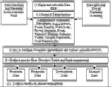
Fig 1. Diagram showed the strategy for sustainable development in Phitsanulok by using GIS
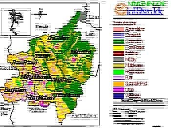
Fig 2. Management Zone Map in Phitsanulok
| Protection Zone | Criteria |
| Natural Parks, Wildlife Conservation Areas,Forestry Areas, etc. | Boundary under the law, government policy and people needs |
| Waterfall, Ancient history area, Eco tourism areas, etc. | Buffer distances 500 m. |
| Upper water shed area, Sensitive area, Deforestation area, Steep area more than 15 degree | High erosion area, forestry area, etc. |
| Sensitive area to environmental change | Terrestrial area adjacent to water bodies including lakes, rivers, ponds, wetlands. Buffer distances 100 m. |
| Rehabilitation area | To rehabilitate infertile soil, barren lands, land out of development zone |
Table 2. Defined criteria on production zone
| Production Zone | Criteria |
| High productivity area | Suitable soil group for agriculture |
| Irrigation area | Boundary of irrigation |
| Non irrigated area | Rainfed area |
| High value added crops an fruit trees | Existing land use map for fruit trees and vegetables |
| Land reformation | Deforestation area but suitable soil group for agriculture |
| Barren land need to rehabilitation for agriculture | Suitable soil group for agriculture |
| Agriculture area in forestry zone | Sustainable production |
| Fishery for commercial | Potential of land, natural resources |
| Animal Husbandry for commercial | Potential of land, natural resources |
Table 3. Defined criteria on Development zone
| Development Zone | Criteria |
| Urban, municipality, rural, village have population more than 500 persons. | Buffer distance 500 m. for sustainable development |
| Super high way, roads, streets, etc | Buffer distance 50 m. for main roads and 20 m. sub-roads.Indochina intersection region |
| Industry and agro-industry | Buffer distance 1,000 m. from urban and rural boundary for heavy industries |
| Airport | Infrastructure for international airport |
| Commercial center, transportation center, warehouse and cargo | Buffer distance not less than 500 m. from urban and rural boundary . Not produce water, air , and noise pollution |
| Mineral resources | Buffer distance not less than 1,000 m. Decision making was done by the stakeholder. |
Table 4. Defined criteria on Multiple zone
| Multiple Zone | Criteria |
| Military zone | Special area for military usage. |
| Buffer zone for protection areas | Buffer distance 100 m. from forestry boundary and 50 m. from water resources |
| Buffer zone for urban, street, industry, etc. | Criteria the same as development zone |
| Conflicts areas between government sector and people | Disagree on land use |
Table 5 The suitable activities for each zones in Phitsanulok province.
|
Zones Activities |
Protection zone | Production zone | Development zone | Multiple zone | ||||
| Conservation | Rehabilitation | Export production | Sustainable production | Urban area | Rural area | Industries and commercial areas | Multiple using areas | |
|
Paddy field |
F | § | · | · | § | · | · | § |
|
Field crop |
F | § | · | · | § | · | § | § |
|
Orchards / Trees |
F | § | § | § | § | · | § | · |
|
Agro-forestry |
F | § | F | § | F | § | F | · |
|
Community forestry |
F | § | F | · | § | § | § | § |
|
forestry Production |
F | § | § | § | F | F | F | § |
|
Fishery |
F | § | · | · | § | · | § | · |
|
Husbandry |
F | § | § | · | F | § | § | F |
|
Waste areas |
F | § | § | § | F | § | § | F |
|
Heavy Industry |
F | F | F | F | F | § | § | F |
|
Medium Industry |
F | F | F | F | F | § | § | F |
|
Small Industry |
F | F | § | § | § | · | · | § |
|
Agro-industry |
F | F | § | § | § | · | · | § |
|
Public park1/ |
§ | § | · | · | · | · | § | § |
|
Tourism2/ |
F | F | § | § | · | · | § | § |
|
Houses |
F | § | § | § | · | · | · | § |
|
Constructions |
F | § | § | § | § | · | § | § |