| GISdevelopment.net ---> AARS ---> ACRS 2000 ---> Poster Session 3 |
Natural-Scientific Approach
for Natural Conservation Using GIS
*Byungyang CHOI.**Takekazu
KOYANAGI.***Yuji KUWAHARA.****Kunio SHIMA
*Graduate Student, Graduate School of Sciences and Engineering, Ibaraki University.
4-12-1Nakanarusawa-cho, Hitachi-city Ibaraki-ken, 316-8511 JAPAN
TEL: (81)-294-38-5165 FAX: (81)-294-38-5249
E-mail: ibaraki@hcs.ibaraki.ac.jp
**Professor, Department of Urban and Civil Engineering, Ibaraki University.
4-12-1Nakanarusawa-cho, Hitachi-city Ibaraki-ken, 316-8511 JAPAN
TEL: (81)-294-38-5165,FAX:(81)-294-38-5249
E-mail: koyanagi@civil.ibaraki.ac.jp
***Lecturer, Department of Urban and Civil Engineering, Ibaraki University.
4-12-1Nakanarusawa-cho, Hitachi-city Ibaraki-ken, 316-8511 JAPAN
TEL: (81)-294-38-5261,FAX:(81)-294-38-5249
E-mail: kuwahara@hcs.ibaraki.ac.jp
****Assistant, Department of Urban and Civil Engineering, Ibaraki University.
4-12-1Nakanarusawa-cho, Hitachi-city Ibaraki-ken, 316-8511 JAPAN
TEL: (81)-294-38-5175,FAX:(81)-294-38-5249
E-mail: shima@hcs.ibaraki.ac.jp
Keywords: Natural-Scientific Approach,
Vegetation, Grade of Vegetation Naturalness, Conservation
*Graduate Student, Graduate School of Sciences and Engineering, Ibaraki University.
4-12-1Nakanarusawa-cho, Hitachi-city Ibaraki-ken, 316-8511 JAPAN
TEL: (81)-294-38-5165 FAX: (81)-294-38-5249
E-mail: ibaraki@hcs.ibaraki.ac.jp
**Professor, Department of Urban and Civil Engineering, Ibaraki University.
4-12-1Nakanarusawa-cho, Hitachi-city Ibaraki-ken, 316-8511 JAPAN
TEL: (81)-294-38-5165,FAX:(81)-294-38-5249
E-mail: koyanagi@civil.ibaraki.ac.jp
***Lecturer, Department of Urban and Civil Engineering, Ibaraki University.
4-12-1Nakanarusawa-cho, Hitachi-city Ibaraki-ken, 316-8511 JAPAN
TEL: (81)-294-38-5261,FAX:(81)-294-38-5249
E-mail: kuwahara@hcs.ibaraki.ac.jp
****Assistant, Department of Urban and Civil Engineering, Ibaraki University.
4-12-1Nakanarusawa-cho, Hitachi-city Ibaraki-ken, 316-8511 JAPAN
TEL: (81)-294-38-5175,FAX:(81)-294-38-5249
E-mail: shima@hcs.ibaraki.ac.jp
Abstract
This study uses the vegetation in order to approach a diversity of the natural resource in the natural park of the Hakusan national park super forest road vicinity region. The natural scientific analysis was carried out using natural parameters such as soil, geology, and geography. It pick up the natural environment in which the protected grade of vegetation naturalness the utilize it. As a result of the overlay analysis, the study area came in grade 9 of the vegetation naturalness rank. It is because where Saseto-kurilensae-Fagion crenatae Fagion crenatae primary forest grows. About 40% of soil was Brown Forest Soils it was observed that the natural condition of the place with the high naturalness, protected the nature of the place which the slope was well over 30 degree. There were many Regosoils in the soil located in the landslide area, and there were some more over 30 degree on the slope. It was understood that there was landslide in relation to soil on slopes by the analysis. The vegetation of which the naturalness was higher than the azimuth was distributed in many for the west direction. This study was able to guess what it should consider in place, when it can grasp the difference between present and past by using latest data and data 10 years ago, in respect of the vegetation, and then it will attempt to protect conserve the natural environment at present. By this it was able to predict the flow of the natural environment, as it showed the possibility of spatially grasping role and importance of the natural vegetation. Introduction
It was adopted convention on biological diversity of Earth Summit in 1992, and in Japan, it is promoting the policy for the protection of biological diversity as an important problem. In addition, it carries out the examination on utilization and sustainable development, while it attempts natural protection and conservation for national land planning and regional development in Japan. The development or the utilization of the natural environment must be considered for protection and conservation of the biology, because it effects largely the survival of the biology. And, it is necessary to sufficiently grasp present state of natural environment in order to realize protection of biological diversity for the protection and conservation of the natural environment.
In the existing study, Harashina(1998) analyzed a habitat environment of the terrestrial mammalian of which the continuity of the forest is important, and Choi(1992) described the status of development and utilization for natural park.
In this study, it mainly examined the analysis of natural environment by the natural-scientific approach such as soil and geology, geography, and vegetation which is important natural component in order to protect original natural environment of natural park.
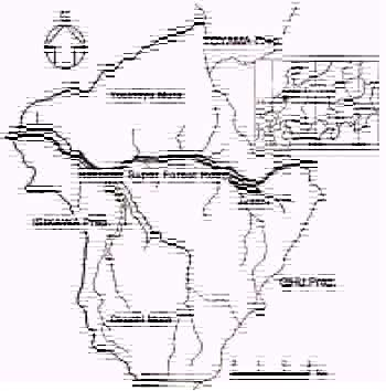
The study area(about 13000ha) is Hakusan super forest road vicinity located in Hakusan National Park, Japan(Fig. 1). It analyzed the natural environment using soil map, geological map, topographical map, existing vegetation map, and aerial photography in order to grasp the natural scientific data of the natural environment. The analysis of the natural environment utilized Geographic Information System.
Outline of the Study Area
The Hakusan National Park of 2702m altitude, which was designated in the 1955 as a Quasi-national Park, when the area became 47700ha it becomes the 20th national park in 1962. Afterwards, it set the park plan (protection plan and utilization plan), and about 38% of the park area became a special protection area.
The Hakusan super forest road of the study area belong to the district in 1967, and made the construction plan along Jadani of the Ojo river upstream, developed by Forest Development Corp. as a super forest road. It constructed this forest road from the Oguchi village of Ishikawa Prefecture to the Sirakawa village of Gifu Prefecture for the purpose of the development of Underdevelopment Forest Resources.
The study area is the mountainous zone of in the center of Hakusan. The climate the Sea of Japan influenced by the Siberia climate, and annual rainfall is pluvial snowy region where it reaches 2000-3000mm(Fig. 2). Hakusan has well protected well alpine zone and subalpine zone. It is the region of the naturalness primary forest of the rich Fagus crenate growth is high. Though the plant community in the study area receives various effects according to temperature, snowfall and land condition, etc., the effect by the snow seems to be the biggest even in the interior.
 |
 |
fig . 1 Location of Study Area |
fig . 2 Topographical Map (3 D) |
This greatly divides the plant community in the study area, into forest and grassland. There are mainly Fagus crenate forest and Thuja standishii-Pius parviflora forest of the sub-alpine in the forest, altherbosa and artificial grassland are located in the grassland.
The animal of the study area is distributed as a center in respect to Hakusan region and Tedori river region. It protects the good natural environment for the inhabitant of the animal. There are many mountains and hilly area in which development has not been done to most of this region. Especially, Japanese macaque, Capricornis Crispus and Japanese black bear of large Mammalia, etc. that mainly inhabit the study area.
Purpose and Method of the Study
Purpose of the Study:
The vegetation is the important element, which constitutes the ecosystem, due to its disaster-preventing important ability and its scientific research importance to the location. And, it shows greatly difference on vegetation growth and recovery according to regionality and land condition.
The study area is necessary to protect the vegetation from conservation of the land resource because it is a region with severe environmental condition climatically and topographically, though primary forest of the beech with the high naturalness is an abounding region.
This purpose of this study shows natural environment spatially and analyzes the relevance from the transition of geography condition and vegetation to analyze present state of the vegetation. This study has two approach for analysis. One is the use of geography information data made from the aerial photograph in order to show the geography characteristics in the study area. The other is to spatially analyze and examine the vegetation transition using the existing vegetation maps of 1975 and 1985, with vegetation distribution and the diversity of vegetation. In a series of examination, it clarifies the relationship of primary information on the relevance between geography characteristics and vegetation distribution such as a slope and azimuth. On the basis of these it analyzed the spatial information to express various natural environment on.
Analysis Method:
The low artificial vegetationGeographic information data used in this analysis are soil map, geological map, topographical map, vegetation map, and aerial photography. It applied the statistical analysis by overlay technique, that classifies the relevance to the natural condition using ARC/INFO(Ver.8.0.1) developed in U.S.A. ESRI Co. in order to digitize all geographic information data in the analysis.
 |
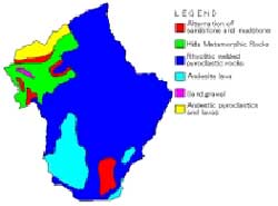 |
fig. 3 Soil Map |
fig. 4 Geological Map |
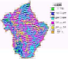
Soil map(Fig. 3) and geological map(Fig.4) utilized 1/200000 map of the Economic Planning Agency in 1974. The topographical map utilized 1/25000 map of Geographical Survey Inst., and the DEM made by using digitizer and TIN of ARC/INFO. The geomorphic area converted DEM into the UTM coordinate, and it made and computed slope figure (fig. 5), and azimuth figure (fig. 6) from the DEM. The vegetation map digitized existing vegetation map of 1/200000 of the first National Survey on the Natural Environment (1975, fig. 7) and 1/50000 of the third National Survey on the Natural Environment (1985, fig. 8) of the Environment Agency.
As the characteristics of the study area, the geography fluctuation is a frequent place of landslide and avalanche. Therefore, it digitized the delicate landscape evolution (landslide and slope failure) which could not be shown by topographical map, after it showed the information in topographical map using aerial photograph (1977)(Fig. 9). It showed spatially biological diversity of the natural environment on the basis of the analytical result.
 |
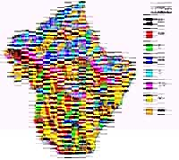 |
fig. 5 Slope |
Fig.6 Azimuth |
 |
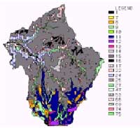 |
Fig. 7 Vegetation Map (1975) |
Fig. 8 Vegetation Map (1985) |
 |
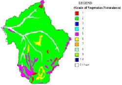 |
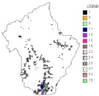
Fig. 9 Landslide Area |
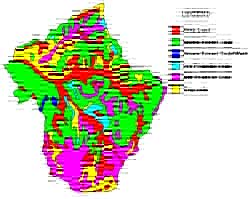
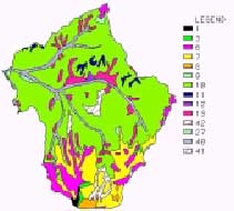
Fig. 10 Grade of Vegetation Naturalness (1975) |
Analysis of Natural Environment
It grasps the place of which the naturalness is of high grade in vegetation, if it protects biological diversity of the natural park, it must be protected and maintained. Since it is the one index which shows ' of which degree remained, in this study, the naturalness which the ' land has used grade of vegetation naturalness (Table 1) for the analysis as the index which grasps natural environment.
| Natural- less |
Definition |
| 1 | hardly the vegetation |
| 2 | the low artificial vegetation |
| 3 | planting forest from middle to sub tree |
| 4 | low or middle of the secondary grassland |
| 5 | high in the secondary grassland |
| 6 | the plantation |
| 7 | the secondary forest |
| 8 | almost a natural vegetation |
| 9 | natural vegetation of the multiple |
| 10 | natural vegetation of the simple species |
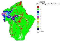
Though vegetation 1975(fig. 10, table 2) was about 90% at naturalness 2(the low artificial vegetation), when it tried to analyze the transition of the vegetation, in 1985 (Fig. 11, table 3), showed about 80% of naturalness lowered. Fig. 12can confirms the difference. With the analysis of the grade of the vegetation naturalness, Saseto-kurilensae-Fagion crenatae was decreased, and was the result. However, the naturalness of the study area is yet high even in it.
| Legend | Vegetation |
| 1 | Vaccinio-Pinetum pumilae |
| 3 | Alpine tall herb stands |
| 6 | Abietum mariesii |
| 7 | Sasa spp.-Betula ermanii community |
| 8 | Alnus maximowiczil community |
| 9 | Sasa kurilensis community |
| 10 | Saseto-kurilensae-Fagion crenatae |
| 11 | Thuja standishii-Pius parviflora community |
| 12 | Polysticho-Pterocaryetum |
| 13 | Alnus pendula-Weigela hostensis community |
| 27 | Cryptomeria japonica plantation |
| 40 | Open water |
| 41 | Natural bare land |
| 42 | Sasa kurilensis community |
Table 3. Vegetation Item (1985)
| Legend | Vegetation |
| 1 | Vaccinio-Pinetum pumilae |
| 7 | Faurio-Caricetum blepharicarpae |
| 8 | Abies mariesii-Betula ermanii forest |
| 9 | Abietum mariesii |
| 10 | Abies mariesii-Fagus crenata community |
| 11 | Sasa spp.-Betula ermanii community |
| 12 | Alnus maximowiczil community |
| 13 | Trollio-Ranunculion acris japonicae |
| 14 | Sasa spp. community |
| 15 | Saseto-kurilensae-Fagion crenatae |
| 16 | Thuja standishii-Pius parviflora community |
| 17 | Polysticho-Pterocaryetum |
| 22 | Altherbosa |
| 24 | Fagus crenate-Quercus mongolica var.grosseserrata community |
| 25 | Castanea crenate-Quercus mongolica var.grosseserrata community |
| 27 | Miscanthion sinensis |
| 47 | Phragmitetum japonicae |
| 53 | Cryptomeria japonica,Chamaecyparis obtusa,Chamaecyparis pisifera plantation |
| 66 | Paddy-field weed communities |
| 69 | Urban and residential district with many trees |
| 74 | Open water |
| 75 | Natural bare land |
There is the relation which is close with soil and slope, since it becomes a factor of landslide and avalanche. Saseto-kurilensae-Fagion crenatae of naturalness of 2 was widely distributed in Brown Forest Soils for old vegetation and new vegetation as the remarkable point in the analysis, and it occupied about 30-40% of the study area. In the old vegetation, Rock Land occupied about 20%, and in the new vegetation, Wet Podzolic Soils occupied about 20%. Regosoils occupied 30% on the soil of (450ha) in the landslide ground which was made from the aerial photography.
In the analysis of the geology, it could not regard noticed change as old vegetation or new vegetation.
 |
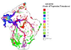 |
Fig. 11 Grade of Vegetation Naturalness(1985) |
Fig. 12 Overlay Analysis for Vegetation |
Rhvolotic Welded Phroclastic Rocks in which about 80% of Saseto-kurilensae-Fagion crenatae of the 2 grade of vegetation naturalness grew occupied about 60% of the whole area.
A slope of 30-50degree increases the danger of a land collapse in. In the analysis, it was distributed for slope 30 –50 degree of both of the naturalness of 2 for about 50%. Altherbosa and Natural bare land mainly existed in the geography condition of the study area in the place of over 30 of degree. However, there is seldom the danger, when noticing point separates from the rill parallel a little.
The landslide is frequent due to weather condition and geography condition. In the inclinatio in the landslide ground, the Regosoils soil saw over 15% over 40-50 degree. It seems that and, there is the relation here with geology (lternation of Sandstone and Mudstone).
The relation between sunshine and its duration which raises the plant is deep for the slope azimuth. The type of the vegetation is different from the speed of the growth by its direction. The azimuth was generally distributed for naturalness of 2, when it classifies the slope azimuth as 8, it regards the naturalness as a relation, since most vegetation is distributed for the naturalness of 2. Especially, 30% of Saseto-kurilensae-Fagion crenatae accupied the whole of west plane occupied whole about.
Conclusion
Saseto-kurilensae-Fagion crenatae Fagion crenatae primary forest which occupies most of the study area comes in at 9 grade of vegetation naturalness. It does not go, if 9 grade of vegetation naturalness does not try for the protection, since academically important vegetation, mainly grows. And, Brown Forest Soils of the forest productivity is usual, and it ought to avoid the modification of the soil, since the land productivity is low for Podzolic Soils. Though steep geography condition is the characteristics of the study area there was the danger in which the slope failure could be generated. Altherbosas, etc. grew by it, and it became the important inhabiting field of the animal. This study will propose natural resource in an attempt to protect conservation of a diversity of natural environment to be considered with the viewpoint in the approach for natural environment.
References
- Harashina, K. Tsynekawa, A. Takeuchi, K. and Takatsuki, S. (1999): Relationships between Connectivity of Forests and Distributions of Terrestrial Mammals in Honshu, Japan of the Japanese Institute of Landscape Architecture, Vol.62(5), 569-572.
- Choi, B., Koyanagi, T. and Itoga, R.(1999): Fundamental on the natural Environmental Assessment and Environmental Consideration to Using GIS, Japan Soc. Environmental Systems Research, Vol.27, 549-554.