| GISdevelopment.net ---> AARS ---> ACRS 2000 ---> Poster Session 3 |
Flood hazard map and land
development priority map Developed using NOAA AVHRR and GIS data
Dr. Md. Monirul
Islam
Research Fellow, Tropical Marine Science Institute
National University of Singapore
14 Kent Ridge Road, Singapore 119223
Tel: 65 874 4649, Fax: 65 872 4067
E-mail: tmsmmi@nus.edu.sg
Singapore
Dr. Kimiteru Sado
Professor, Kitami Institute of Technology
165 Koen-cho, Kitami 090-8507
Tel. 81 157 269492, Fax. 81 157 239408
E-mail: sado@hp712.civil.kitami-it.ac.jp
Japan
Keywords: NOAA AVHRR data, Flood-affected
frequency, Population density, Flood hazard map, Land development priority
mapResearch Fellow, Tropical Marine Science Institute
National University of Singapore
14 Kent Ridge Road, Singapore 119223
Tel: 65 874 4649, Fax: 65 872 4067
E-mail: tmsmmi@nus.edu.sg
Singapore
Dr. Kimiteru Sado
Professor, Kitami Institute of Technology
165 Koen-cho, Kitami 090-8507
Tel. 81 157 269492, Fax. 81 157 239408
E-mail: sado@hp712.civil.kitami-it.ac.jp
Japan
Abstract:
In this paper flood hazard map and land development priority map for Bangladesh were developed using the flood events of 1988, 1995 and 1998 data with the digital data of physiographic divisions, geologic divisions, land cover classification and population density those were used as Geographical Information System (GIS) data. The techniques to construct a map for land development on the priority basis against the flood damages were described. Flood-affected frequency and flood depth were considered as hydraulic factors, and special attention were paid on population density for the land development priority map. Flood hazard assessment was undertaken using National Oceanographic and Atmospheric Administration (NOAA) Advanced Very High Resolution Radiometer (AVHRR) with GIS. Flood-affected frequency and flood depth were estimated using NOAA AVHRR images. Flood hazard ranks were categorized using the flood affect on land cover classifications, physiographic and geologic divisions.
Introduction
There have been many destructive floods in Bangladesh including very severe floods of 1987, 1988 and 1998. The 1988 flood set new record for flooded area while 1998 flood set new record for its long duration. In 1988, Bangladesh experienced one of the worst floods in living memory, and then the study team comprised a core group of international consultants provided by UNDP, the Asian Development Bank, the European Economic Community and the world bank (World Bank 1989) and local experts who investigated the flood damages and its remedy. Bangladesh lies in the downstream area of the three river basins of the Ganges, Brahmaputra and Meghna. The three mighty rivers the Ganges, Brahmaputra and Meghna, enter Bangladesh from India through northwest, north and northeast of the country, respectively. High magnitude of floods strike on a regular basis in these three river basins in Bangladesh, India and its peninsular (Bhattacharyya 1997; Islam & Sado 2000a;b; Kale & Pramod 1997; Kundzewich & Takeuchi 1999; Muramoto 1988) because of the passage of depression and cyclone storm during the monsoon season. Bangladesh has limited control over the Ganges, Brahmaputra and Meghna rivers, moreover, for adequate and timely flood forecasting, Bangladesh sometimes depends on information from surrounding countries. The frequently occurring floods are very costly in terms of human hardship and economic loss. Therefore, the ability to estimate damages associated with the flood events are very important and necessary to evaluate future alternate flood control policies. In a round-table discussion following 1998 flood event, experts from different fields recommended the need for flood hazard maps for proper planning and management for future flood disaster (Nishat 1998). In our previous studies (Islam and Sado 2000 a; b) we have developed flood hazard maps only using 1988 event. Therefore, in this study we focus on the historical events of 1988 and 1998 severe floods and 1995 medium flood. NOAA AVHRR data are found very useful for monitoring large surface phenomena, such as floods, in the fields through out the world on local, regional and international scales while ERS, MOS, Landsat and SPOT has been used to observe regional or local floods. Furthermore, the routine measurement and the estimation of hydrological parameters including flood-related parameters could be useful in the areas ranging from global scale to local or regional scales, depending on the spatial resolution and recurrent period (Schultz 1994). The time of acquisition of satellite data does not generally coincide with the time of flood peak or maximum inundated area. The data and time of data collection and recurrent periods of satellite imaging are important for investigation of satellite data (Oberstadler et al. 1997). Therefore, in this paper result of analysis of NOAA AVHRR data, from the series of NOAA satellite 10 and 12, are used for the flood hazard assessment in Bangladesh and the construction of flood hazard map and land development priority map.
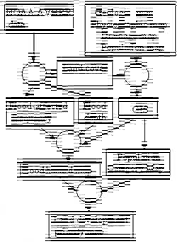
Figure 1. Schematic concept of model
Flood Hazard Assessment
Study proved that the combination by land cover, physiography and geology is the best combination of GIS data for each of the flood hazard map performed for flood depth and flood-affected frequency (Islam & Sado 2000b). Therefore, flood hazard assessments were undertaken using land cover, physiographic and geologic features and drainage network data. Land cover classification was carried out using dry season's NOAA AVHRR image of 20 January 1988. Land cover data, drainage network data, physiographic and geologic features were used as GIS data. Flood depth and flood-affected frequency were used as hydraulic parameters of the floods. A model was considered for the assessment of the flood hazard, which is shown in Figure 1.
Flood-affected Frequency
Flood-affected frequency within the event of 1988, 1995 and 1998 were estimated by using the images of 18 September 1988, 31 October 1995 and 18 September 1998. The terminology of flood-affected frequency is determined for each pixel as the ratio of the number of NOAA images within the three flood events of 1988, 1995 and 1998, showing inundation to the total number of cloud free NOAA images available near to the peak flood time. The concept of the different degree of flood-affected frequency is shown in Figure 2. Inundated area that did not appear in any of the above mentioned three images (i.e. 8 in Fig.2) were considered to be a non-hazard area and that which appeared in a single image (5, 6 or 7 in Fig. 2) was considered to be a low hazard area. The common inundated area that appeared in two images (2 or 3 or 4 in Fig. 2) and that which appeared in all three images (1 in Fig. 2) were considered to be medium and high hazard areas, respectively. Flood-affected frequency within the three events was categorized as non-hazard, low, medium and high according to their hazardous hit number of the floods.
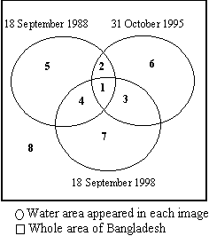
Figure 2: Schematic concept of flood-affected frequency for the flood events of 1988, 1995 and 1998
Flood Depth
Flood depths were classified as shallow, medium and deep by using the maximum likelihood method of supervised classification for the same images. Training areas for shallow, medium and deep flood were selected on NOAA AVHRR images of 18 September 1988, 31 October 1995 and 18 September 1998 according to the difference in colors and gray scales for different categories of depth. To measure the flood depth using remote sensing imagery is very difficult. The differences among the depths were understood after superimposing the NOAA images onto the digital elevation image of Bangladesh. Furthermore, the ranking for flood depth was categorized as no-flooding, shallow, medium and deep flood. Therefore, three flood depth maps were constructed for three flood events of 1988, 1995 and 1998 by using above-mentioned images, respectively.
Hazard Rank Assessment Through GIS for Flood Hazard Map
Flood hazard ranks were estimated based on a weighted score for land cover, physiography and geological data for each pixel of the land area of Bangladesh. A weighted score was estimated by
where A, B, C and D represent the occupied area percentage by non-hazardous area, low, medium and high flood-affected frequency, respectively, for each category of land cover categories (9 categories), physiographic divisions (31 divisions) and geologic divisions (28 divisions) (Islam & Sado 2000b ), when flood-affected frequency was considered to be a hydraulic factor. Similarly, A, B, C and D represent the occupied area percentage by non-flooded area, shallow, medium and deep flood, respectively, for each category of above mentioned GIS component, when flood depth was considered to be a hydraulic factor. The coefficients of 0.0, 1.0, 3.0 and 5.0 for A-D in equation (1) were used to describe the weight for flood damage. The acquired area percentage by non-hazardous, low, medium and high damaged areas only for the land cover categories are shown in Table 1 with calculated weighted score. Points for the categories of land cover were estimated on the basis of linear interpolation between 0 and 100, where 0 corresponds to the lowest (0) and 100 to the highest (230.21 in Table 1) weighted score. To quantify the flood hazard, the three rankings for flood damage (HR 1~3) were obtained from the allocated point. Hazard ranks were fixed according to the corresponding value of the points: points 0-33 corresponded to hazard rank 1, 33-66 rank 2 and 66-100 rank 3, as shown in Table 1. Similarly hazard ranks were determined using the same algorithm for geologic divisions and physiographic divisions, using flood-affected frequency. Different four categories of flood depth were estimated independently for the images of 18 September 1988, 31 October 1995 and 18 September 1998. Hazard ranks were determined for each event using the above-mentioned algorithm for physiographic divisions, geologic divisions and land cover categories, using flood depth.
| Cat. | A | B | C | D | Score | Points | HR |
| 1 | 36.93 | 28.49 | 22.01 | 12.57 | 157.38 | 68.36 | 3 |
| 2 | 29.88 | 19.22 | 21.73 | 29.17 | 230.21 | 100.00 | 3 |
| 3 | 28.29 | 23.08 | 26.17 | 22.46 | 213.89 | 92.91 | 3 |
| 4 | 55.84 | 23.14 | 12.70 | 8.32 | 102.82 | 44.66 | 2 |
| 5 | 47.54 | 26.05 | 14.58 | 11.83 | 128.93 | 56.01 | 2 |
| 6 | 60.93 | 22.54 | 13.46 | 3.07 | 78.29 | 34.01 | 2 |
| 7 | 77.11 | 12.59 | 5.55 | 4.75 | 52.99 | 23.02 | 1 |
| 8 | 42.96 | 33.66 | 14.03 | 9.35 | 122.52 | 53.22 | 2 |
| 9 | 16.98 | 30.67 | 34.84 | 17.51 | 222.76 | 96.76 | 3 |
Development of Flood Hazard Map
Flood hazard maps were constructed by considering the interactive effect of flood damages onto the land cover categories, physiographic and geological divisions. The concept of the ranking matrix in three dimensional multiplication modes is shown in Figure 3.
Flood hazard map using flood-affected frequency as hydraulic factor:
Flood-affected frequency consisted of four classes: non-hazardous, low, medium and high damaged areas. Hazard ranks were considered from 1 to 27 after combining the hazard ranks of land cover categories (HR 1-3), physiographic divisions (HR 1-3) and geologic divisions (HR 1-3) simultaneously, using the ranking matrix of three dimensional multiplication modes (Fig. 3).
Flood hazard map using flood depth as hydraulic factor:
Flood depths consisted of four classes: non-flooded area, shallow, medium and deep flood. Initially three different hazard maps were developed for three above mentioned images by considering the interactive effect of land cover categories, physiographic divisions and geologic divisions onto the flood depth, using the ranking matrix (Fig. 3). Each hazard map consisted of hazard ranks from 1 to 27. Finally, hazard map of 1988 event for the flood depth was selected as a hazard map among the three hazard maps, because this hazard map shows the deviation in the marginal distribution toward higher ranks compared with other two hazard maps.
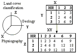
Figure 3: Concept of the ranking matrix
Interactive effect of flood-affected frequency and flood depth for the development of flood hazard map:
Two flood hazard maps were developed for flood-affected frequency and flood depth, respectively, considering the flood hazard rank from 1 to 27. In these two hazard maps, 56.31% pixels exhibited the same hazard ranks and 43.69% were different, because flood-affected frequency and flood depth were considered independently. Comparing between the hazard maps of flood-affected frequency and flood depth, higher rank for a pixel was assigned for that pixel for the new developed hazard map. Watercourses were not included to the developed flood hazard map. Therefore, the drainage map was overlaid onto the hazard map, and final hazard map with watercourses is shown in Figure 4.
Development Priority Map for Flood Countermeasure
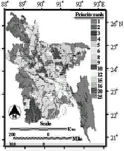
The major cities of Bangladesh are extremely highly populated area. The planning of river works for flood countermeasure should be undertaken by considering the economical effects of the infrastructure and the importance of the concerned area. Therefore, using flood hazard map and population density map land development priority map was developed. Digital population data was prepared using population map of Bangladesh. Urban and industrial areas show high dense of population, while agricultural low land and agricultural flat-plain show low dense of population. According to the population density, the population digital data was categorized into five zones. The area which shows the population density 1 to 500 per square kilometer was considered as zone 1, similarly, the areas which show the population density 501 to 1000, 1001 to 2500, 2501 to 4000 and over 4000 were considered as zone 2, zone 3, zone 4 and zone 5, respectively. Similarly, hazard ranks of flood hazard map were categorized into five groups. Hazard rank 1, 2 and 3 is grouped as 1, then similarly, 4 and 6 is 2, 8 and 9 is 3, 12 and 18 is 4, and 27 is 5. This new hazard grouped map was superimposed with population digital categories map and finally the land development priority map was developed using the ranking matrix of two dimensional multiplication modes. Figure 5 shows the land development priority map for flood countermeasure based on pixels. The ranks of land development map are ranging from 1 to 25. Higher ranks indicate the higher priority has to be given for the development for flood countermeasure. This development priority map shows the rank of priority on the basis of pixel. Comparing between the hazard map (Fig. 4) and the development priority map (Fig. 5), it is understood that some high hazardous areas do not show the high rank for the development. The northeast part of the Meghna river and southwest lower parts of Bangladesh show high hazard ranks whereas development map shows the low ranks for the development of the same areas. Some part of Dhaka and Narayanganj districts show the higher development rank due to the high dense population. Dhaka is the capital city of Bangladesh. Study showed that Dhaka city was highly affected during the 1988 flood (Sado & Islam 1997).
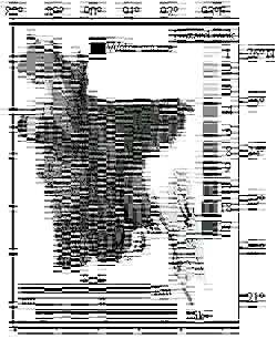
Figure 4: Flood hazard map
(Monochrome fig. produced from original color fig.)
Figure 5: Land development priority map
Conclusions
Flood hazard assessment were undertaken considering the interactive effect of flood-effected frequency and flood water depth, those were estimated from NOAA AVHRR images of 18 September 1988, 31 October 1995 and 18 September 1998, and finally a new flood hazard map for Bangladesh was developed. Flood hazard map represents the magnitude of flood damage for each pixel. Land development priority map for flood countermeasure were developed based on each pixel. Although flood hazard ranks for some urban areas are comparatively less than the hazard for some rural areas, development should be undertaken for those urban areas (higher dense populated area) on first priority basis. The results described in this study should provide helpful information for flood control planning and the construction and development of flood countermeasures. Flood hazard map and land development priority map also help the responsible authorities to better comprehend the inundation characteristics of the flood plains, the protection of which is their responsibility. Relief and aid operation can be performed by using flood hazard map for further future events.
References
- Bhattacharyya, N. N., 1997. Floods of the Brahmaputra river in India. Water International, 22(4), pp. 222-229.
- Islam, M. M. & Sado, K., 2000a. Flood hazard assessment in Bangladesh using NOAA AVHRR data with geographical information system. Hydrol. Process. 14(3), pp. 605-620.
- Islam, M. M. & Sado, K., 2000b. Development of a flood hazard maps of Bangladesh using NOAA-AVHRR images with GIS. Hydrological Science Journal, 45(3), pp. 337-356.
- Kale, V. S. & Pramod, H., 1997. Flood hydrology and geomorphology of monsoon-dominated rivers: the Indian Peninsula. Water International, 22(4), pp. 259-265.
- Kundzewich, Z. W. & Takeuchi, K., 1999. Flood protection and management: quo vadimus?. Hydrological Science Journal, 44(3), pp. 417-432.
- Muramoto, Y., 1988. Investigation of the flood disaster caused by heavy rainfall in Bangladesh during the 1987 monsoon season. Report of Scientific Research for Natural Disaster, no. B-62-5, Ministry of Education, Tokyo, Japan.
- Nishat, A., 1998. A discussion on flood management in Bangladesh. The 1998 Deluge-Developing Coping Capacities, Workshop on the 1998 flood, Nagorik Durjug Mokabela Uddogh, Dhaka, Bangladesh.
- Oberstadler, R., Honsch, H. & Huth, D., 1997. Assessment of the mapping capabilities of ERS-1 SAR data for flood mapping: case study in Germany. Hydrol. Processes,11, pp. 1415-1426.
- Sado, K. & Islam, M. M., 1997. Satellite remote sensing data analysis for flooded area and weather study: case study of Dhaka city, Bangladesh. J. Hydraul. Engng., JSCE, 41, pp. 945-950.
- Schultz, G. A., (1994). Meso-scale modelling of runoff and water balance using remote sensing and other GIS data. Hydrol Sci. J. 39(2), pp. 121-141.
- World Bank, 1989. Bangladesh Action Plan for Flood Control. 91, Asian Region, Country Department-1, World Bank, Washington DC, USA.