| GISdevelopment.net ---> AARS ---> ACRS 2000 ---> Poster Session 3 |
The Development of Forest
Fire Forecasting System using Internet GIS and Satellite Remote
Sensing
Myung-Hee Jo* Myung-Bo
Lee**, Si-Young Lee**, Yun-Won, Jo* Seong-Ryul Baek*
*Department of Geodetic Engineering, Kyungil University
33 Buho-ri, Hayang-up. Kyungsan-si, Kyungsan bukdo,
712-701, Korea
Tel)+82-53-850-7312, Fax)+82-53-854-1272
E-mail: mhjo@bear.kyungil.ac.kr, gerry@w3.ko, fosco@hanmail.net
** Div. Forest Environment, Korea Forest Research Institute,
Tel)+82-2-9612-744 Fax)+82-2-9612-543,
E-mail: leemb@foa.go.kr, LSY925@chollian.net
Keywords : Satellite Image, Forest Fire Hazard
Index, Internet GIS *Department of Geodetic Engineering, Kyungil University
33 Buho-ri, Hayang-up. Kyungsan-si, Kyungsan bukdo,
712-701, Korea
Tel)+82-53-850-7312, Fax)+82-53-854-1272
E-mail: mhjo@bear.kyungil.ac.kr, gerry@w3.ko, fosco@hanmail.net
** Div. Forest Environment, Korea Forest Research Institute,
Tel)+82-2-9612-744 Fax)+82-2-9612-543,
E-mail: leemb@foa.go.kr, LSY925@chollian.net
Abstract
The purpose of this study is to develop the most effective method for a forest fire forecasting in small mountain through GIS and Remote Sensing. The study area was Young-chon area including all of the Kyung-sang Province, Korea. GIS DB was constructed based on factors of geographical and natural features those are necessary factors to forecast a forest fire. It was clarified that satellite image and some spatial data is very effective for developing the Graphic User Interface to forecast the forest fire using Internet GIS. In addition, the forest fire hazard area was prevented and managed effectively.
Introduction
Recently the human lives, fortune and the ecosystem have been deadly threatened by the many cases of forest fire and it's huge size. Even though there is trip of extinguish equipment, the main reason of this large sized forest fire is that there is limitation of traditional method and no more scientific way to predict these disasters.
In this paper, we present that the fatal damage by forest fire could be reduced if there are suitable predictions and rapid provision against forest fire using Internet GIS. This Internet GIS modeling is the most perfect way for forest fire forecasting system because forest fire has a movement in both in spatial and temporal.
CFFDRS(Canadian Forest Fire Danger Ration System) was developed for a prediction of forest fire in 1987 and GIMS(Geographical Information and Modeling System) was installed for a management of it by Kessell(1990). GIMS could assign a part by telling the shape of forest fire in real time and help the managers of forest fire have best decision against these disasters. In 1993 Gracia and Lee prepared a map for forest fire forecasting in Alberta after evaluating the main danger factors of forest fire.
In Korea, Y.H Cheong(1989) studied about predicting the dangerous rate of oxidation and S.Y Lee(1990) found out the relationship between the factor of environment and temperature of forest fire . K.C Lee(1998) constructed the modeling of suitability analysis about forest fire extinguish water tank using GIS .
The study purposes of this paper are as follows that the investigation into actual condition of forest fire in Young-chon area was first carried out and secondly constructed in to GIS DB. Danger index of forest fire was computed with the based on topographic and meteorological factor in this area and evaluated the relationship between these factors and forest fire. Finally, the network presentation system of that using Internet GIS, which is the main goal of this paper, was installed.
Review on Physical Factors of Forest Fire in Study Area
In the view of season, the number of forest fire increase in the spring and the winter because it is very dry and small amount of precipitation. 3,362 cases took places between 1990~1999 and the damaged area was 13991.43ha. Among them 2,069 cases happened between March and April and 883 cases occured in the winter. The main reasons of forest fire in this area have been composed of accidental fire(44%), ditch burn up(22%), visit tomb accident fire(7%), playing with fire(5%), etc(23%). 49% cases of them took places around 2 p . m ~ 6 p . m, 38% took places 11 a . m ~1 p . m, 9% took places 7 p . m ~ 4 a . m, 4% took places 5 a . m ~ 10 p . m in order.
In study area, 84.2% cases of forest fire happened from March. 21 to April 10.
The potential factors including aspect, elevation, slope, stream, vegetation, which can have an effect on forest fire were extracted for probability analysis.
Aspect is related to the amount of sunshine. In general, the cases of forest fire occur in area of south more than in the area of north because a southern exposure has higher burning point.
Actually, more than 40% of forest fire happened in aspect of south area while it doesn't happen in the other area. Therefore, the aspect is really related to forest fire. Comparing with previous forest fire, more than 90% cases of forest fire happened at 100m above the sea level. Most these disasters take places in lower area above the sea level. 65 % cases in entire forest fire occurred in between a slope of zero and a slope of twenty degrees. The rate of forest fire decrease remarkably as slope increases.
Stream is regarded as an important role not only to extinguish forest fire but also to provide moisture toward plants. The area far from stream has higher dangerous factors. Especially, the road can be immediate factor to forest fire because there are human beings.
Fuel, which is composed of the amount of precipitation, the humidity of air, the direction of the wind and temperature, is very related to season, and time.
In study area, the air is exceedingly dry in the winter and much precipitation is in the summer. Also, its north, west, east is consisted in a mountainous area, which is over 900 meters above the sea level. There are open field in its south area and cultivated fruit.
The Kum-ho river, which is joined with Nam-chun(Jaho-chun, Gokung-chun) and Buk-chun(Sinryung-chun, Gohyun-chon), is flowed in the middle of this study area. The size of this is 919 and 69% in this area is forests and crop fields and 18% is cultivated area.
In 1999 the number of a broad-leaved tree was twice than the number of a needle-leaf tree while the number of both was same. By analyzing Landsat TM satellite image data, the classes of trees are consist of 55% of Coniferous, 30% of Deciduous, 15% of Mixture forest.
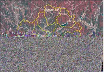
Figure 1. The location of study area
Materials and Methods
In this paper the classes of trees in this area were simply composed of Conifer, Deciduous, Mixed forest, and Agriculture. And the dimensions of damage area, the classification of vegetation and land classification map were found out by Landsat images.
The spatial data including topographic map, geologic map and aerial photo was used to make forest fire hazard index GIS DB. ERDAS IMAGINE 8.3 and Unix Arc/Info GIS tool for image processing and spatial analysis are used and Map Object 2.0 and Visual Basic 6.0 for Internet Network are needed. Virtual GIS is applied to realize forest fire hazard index on 3D terrain.
Topographies of three areas, which are called Hawsan, Hawnam, Jungang in Young-chon city, are analyzed. More than 60% of forest fire happened in between a slope of zero and a slope of twenty degrees and in aspect of south and southern west. Places of those disasters occurred between 100m and 350m above the sea level and close to road, which is far from river.
| Area | Date | Temperature | Precipitation(mm) | Damage(ha) | Vegetation |
| A | 1999/4/15 | 10.43 | 42.5 | 5 | Conifer |
| C | 1999/3/31 | 8.55 | 0 | 1.5 | Conifer |
| G | 1999/3/4 | 4.97 | 18.5 | 1.5 | Deciduous |
After analyzing above table1, the main factors which could affect forest fire, are needle-leaf trees the aspect of southern west and humidity.
Forest fire hazard index could be extracted by using average data acquired from an observation station based on three above factors and presented it in a contour line.
In general, predict modeling was used like density transfer, density regression, significance regression, discriminate function analysis, logistic regression. In this research, logistic regression was considered most suitable analysis because it could compute difference of a variable environment between occurrence spot, in addition nonoccurrence spot and applied to undetected area yield probability.
Zi = 3.754 + 0.231×(slope) + 0.324×(elevation)+ 0.165×(aspect) + 0.328×(stream) + 0.195×(forest type) + -0.017×(agricultural pattern) + -0.128×(urban) + 0.030×(road)+ 0.872×(rainfall)+ 0.652×(sunshine)+0.713×(moisture)
Pi = exp(Zi) / (1 + exp(Zi))
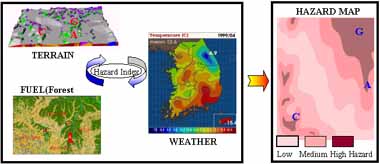
Figure 2. Hazard Map on Study Area
Forest fire hazard Index Forecast System using GIS
Development of Forecasting System
The purpose of this study is to develop the most effective method for a forest fire forecasting through GIS and Remote Sensing. In this study digital map was prepared and expressed numerically which includes factors of geographical and natural features, which are necessary factors to forecast a forest fire hazard index.
Fire potential requires collecting baseline vegetation information, daily to weekly monitoring of vegetation condition or vigor daily monitoring of weather conditions, and acquiring risk management information.
A computer-based model is to predict wild fire behavior across time and space. The computer model uses fuel type, weather conditions, slope, aspect and elevation to predict the direction, speed, and burn intensity of a wild fire across various landscapes. The model uses Geographic Information System (GIS) technology. The program is responsible for all the complex computations necessary for simulating fire behavior.
The model's user-interface is designed so advanced computer skills and GIS knowledge is not required to execute the model. Ease-of-use puts fire behavior prediction into the hands of fire managers where it can be most effectively applied. With fire damage growing every year, fire departments need better planning tools to minimize fire's impact.
The model is also a good analysis tool for resource managers. A Graphic User Interface (GUI) allows the user to easily specify and edit the data and parameters necessary to execute each simulation. Forest fire Danger Index Presentation System would be useful to managers, policy makers and scientists interested in mitigating and evaluating the effects of forest fire. Real time forest fire hazard information is offer to public welfare and administration business management.
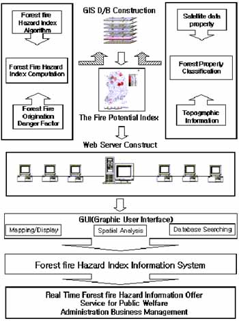
Figure 3. Procedure of Study Frame
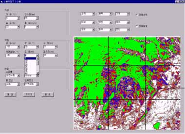
Figure 4. Forest Fire Hazard Index Presentation System
Conclusion
In conclusion, the information of forest in the specific area can be easily searched, analyzed and managed through Internet GIS and Remote Sensing. It makes possible for this forest fire forecasting system to predict and to prevent forest fire in effective and scientific because it can assume exact forest fire hazard index in real time and present in proper time. Especially forest fire hazard index was presented in real time integrated with meteorological data through internet web base to forest fire task officer and local citizens without time lagging. It also allows to analyze with spatial modeling and monitoring in the predicted area. Therefore it was clarified that the forecasting system using Web based GIS is prominent for management and prevention of forest fire.
References
- An, Sang-Hyun, 2000, A Forest fire prevention mechanism using Geographic Information System - The case of Uam Mt. In Chungju-, Chungbuk National University, Korea.45p.
- Beck, J.A., 1989b, A geographical information and modeling system for the management of wildfire incidents, Proceedings, Urban and Regional Planning Information Systems, 17, p.474.
- Chou, Y. H., 1990b, Modeling fire occurrence for wild land fire management: A GIS spatial analysis. In Proceedings of the GIS/LIS'90 Conference, November 7-10, 1990, Anaheim California, pp.440-449.
- Donoghue, L.R., and Main, W. A., 1985, Some factors influencing wildfire occurrence and measurements of the prevention effectiveness, Journal of Environment, 20, pp.87-96.
- Kim Y.S, Suh A.S, Jo M.H, 1998. Introduction to Remote Sensing, DongHwa Technology Publishing Co, 373p.
- Kyung Choi, Hong Sub Lee, Ho Joong Youn, Jae Heun Kim, 1994, Selection of tree species to mitigate landslide hazard, Res. Int. No.49l, pp.103-109.
- Myung-Hee Jo. 1989. Land cover classification using Landsat TM image; The case of the Nak-Tong River mouth area, Ph.D.Thesis, Kyungpook National Univ.,Korea, 154p.
- Myung-Hee Jo. 1995. A Geomorphologic study on coastal land classification using satellite remote sensing and GIS.
- Piwower, J.M., Ledrew, E. F., and Dudycha, D. J., 1990, Integration of spatial data in vector and raster formats in a geographic information system environment. Int.J.Geographical Information Systems, Vol.4, pp.429-444.
- R.W.Klaver, A.Singh, Global Forest Fire Watch:Wildfire Potential,Detection,Monitoring and Assessment: http://www.usags.gov/
- Si Young Lee, Yeon Ha Cheong, Bong Soo Lee, 1996, Analysis of the spread rate and behavior pattern of forest fire using digital topographic data. Vol.53, pp. 186-193.
- Stephen R. Kessell, 1990, An Australian geographical information and modeling system for natural area management, Int.J. Geographical Information Systems, Vol.4, No.3, pp.429-444.
- The Annual Report of Youngchon City: 1996,1997,1998,1999.
- Yue Hong Chou, 1992, Management of wildfire with a geographical information system, Int.J.Geographical Information Systems, Vol.6, No.2, pp.123-140.
- Yun-Jung Kim, 1996, A study on predictive modeling of Forest fire: The case of Puk'ansan National Park, Ewha Womans University, Korea.75p.
- Yeon Ha Cheong, Si Young Lee, Yuk Cheol Yeom, 1994, Evaluation of forest fire warning period and estimation of forest fire danger rating index, Res. Int. No.49, pp.92-102.