| GISdevelopment.net ---> AARS ---> ACRS 2000 ---> Poster Session 3 |
A R&D Program for Prompt
Response about Forest-Protection Information with Platform Display
System
Gwo-Jern Hwang1
Ching-Ming Wu2 Ten-Yin Chou3 Joou-Shiau
Lee4
1Taiwan Forestry Bureau (TFB),#2,Sec.1.Hang-Chows.Rd.Taipei Taiwan 100
2 , 3Geographic Information System Research Center, Feng Chia University
4The Department and Graduate Institute of Forestry, National Chung-Hsing University.
E_mail: n1206153@pagic.net
Abstract1Taiwan Forestry Bureau (TFB),#2,Sec.1.Hang-Chows.Rd.Taipei Taiwan 100
2 , 3Geographic Information System Research Center, Feng Chia University
4The Department and Graduate Institute of Forestry, National Chung-Hsing University.
E_mail: n1206153@pagic.net
The Taiwan Forestry Bureau (TFB) is the major agency, which is authorized to manage the national forest. TFB has been a research for forest fire precaution and rescue from 1999.
In that research, the forest patrolman is equipped with radio interphone, GPS receiver, and potable Laser gun. The forest patrolman traces route can be recorded by GPS receiver and key in different code when he comes across various forest disasters. In case of fire emergence, interphone can be used to report to rescue center immediately and transmitted the coordinates of fire location and it's boundary, which are identified by Laser gun. The control system in the rescue center will compute the area and overlay the fire position on digital map. When fire-fighting team arrive the scene, digital video is using to catch the image of the fire development and ISM BAND Microwave Radio System is used to transmit to the rescue center.
Original of the Research
Forest, the land of nature, not only for its rich resources, but also it affects related to our natural economy and livelihood. However, fire emergence, plant blight, illegal cutting and unlawful cultivation happen in the forest, endanger the circumstance from peaceful and quiet. If we cannot prevent and control those factors, they will threat the forestry development and increase water and soil erosion rate. Therefore, 210 protection-management offices were set up by TFB. Besides, 450 protection-management areas were delineated from forest location, traffic, construction, residents' distribution and the disasters over the years (1998 TFB.). The protection-management officers have the obligation to patrol and report for rescue on time, and reduce the disasters and damage to minimum.
Nevertheless, it is still a difficult task to patrol and manage the mountainous area without a vast expanse. The office usually know the result after the patrolmen come back from the field and fill-up the report forms step by step, which is useless to prevent from disasters. Once disaster happened, the patrolmen only can describe the situation in the scene, and the executive officers fill the report and submit to higher level. Because the return-time is always delayed or the message is possible error, the commander may instruct wrong direction from the scene, therefore, the emergency rescue timing will be delayed.
Research Content
In this research, we aim at the disadvantages of the currently forest patrol system and disasters return-report to draft the improvement, moreover, we plan 3 targets:
- The patrolmen's position is located and displayed on digital map immediately
- The present disaster scene images can be transmitted and displayed on the digital map platform immediately
- The report of the forest-protection form can be inquired and transmitted by Internet.
Major Techniques
Digital Map
In the past, the disaster location was only displayed on the paper maps that pieced up on the wall of the disaster rescue center. Besides, only the officers who were familiar with local environment could search the location on the maps quickly. When the disaster expanded, or it is necessary for a mobile rescue center, paper maps have some problems, such as it is difficult to carry and handle, the information is insufficient, the update speed is too slow, etc. This research engages in creating a Digital Map by digitizing, editing, and coordinates transformation to build forest topographic chart and advanced automatic mapping technology (Yang long-shi, 1998).
Geography Information System (GIS)
GIS includes hardware, software, spatial and attributes data link, and data analyze integration, such as topological data structures database management and spatial analysis. The users can build, collect, and save points, lines, polygon, and the changes of landforms (spatial data); as well as business forms, reports, measurement, diagrams (attribute data). The maps can be saved in different layers' contents, make it easy to draw, display, inquire, save and distribute. This research program to analyze and create different statistics data. After that, the result can be displayed by 3D, and the result were applied to business management, resources management, ground exploitation, maps management, production management, diseases control, environmental protection, etc.
After the skills of GIS are applied generally, the system builders can combine with Object-Oriented Programming to build executable software; or build some business GIS functions by GIS module. The users do not have to buy the complete set of GIS software since it's common windows based, and it offers the GIS functions through Internet (Fig.1). Thus, it effectively develops the functions of support and decision to execute the business of forest protection (Zhong lan-kun, 1999).
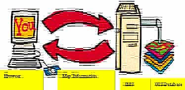
Fig.1 Structure of WWW-GIS
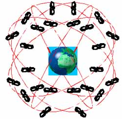
Fig.2 GPS constellation
Global Positioning System (GPS)
GPS is used to measure the time and distance by satellites (Fig.2), and offers the global, all-weather, three-dimensional space, three-dimensional speed, continuous, immediately high precision navigation message (Liu ji-yu, 1993). The research only gather the message of the GPS's electromagnetic wave with the GPS receiver and calculate precisely the coordinates of the object's position, timing, and ranging by the theory of fore intersection at any movement and any place.
Presently, GPS is widely popularized to different business in the world. Those application include mounting, traveling, hunting, engineering, disaster protection, mapping, natural resource exploration, land development, space expand, scientific research, earth crust monitor, precise geodesy, intelligent transportation, vehicle navigation, and GIS investigation, etc.
"GPS User's Unit" indicates the GPS receiver, engine chip, or the processing board in the computer module (Fig.3 User's Unit). Those shape and size is quite different. The precise Geodesy type is bigger and heavier than the engine chip that is similar as a stamp.
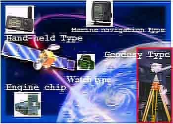
Fig.3 GPS User's Unit
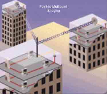
Fig.4 Wireless radio Internet technique
Radio Imagine Transmitting
Internet technologies shorten human range and create a convenient life style. The problems that is derivative from the Internet cable would be urgent to solve, such as massive wiring engineering, long interval of system setting up, maintenance of the old fashion or damage set, etc. Fortunately, the wireless radio Internet technique (Fig. 4) is exploited and overcome those problems on time.
Research projects
System Structure
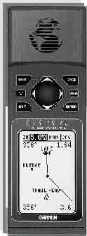
The system can be installed on every Forest Protection-Management Offices and their workstations in the future. It is necessary to consider about the simple setting up, easier operation, quicker maintenance, etc. By using the system (Fig.5) the patrolmen record the coordinates of their patrol path into the hand held GPS receiver (Fig.6) automatically (Chou Ten-Yin) and enter the coincident definition code from the key board when they come across the illegal cutting, unlawful cultivation, collapse areas, etc.
The Interface in System
The systems include complete data transmitting and receiving interface (Fig.7). It can be installed in anyone compatible x86 computer, to transfer data mutually by transmitting interface. It is probable to install in notebook computer, so that rescuers can operate with the equipment in forest calamity region. Due to this reason, the design to establish in individual operating system in computer, is different from the dispersed structure (N-Tier) ° This individual operating system can keep best mobility and simplification, even if necessary, to set up temporary rescuing control commander to support rescuing work with installing one set of equipment.
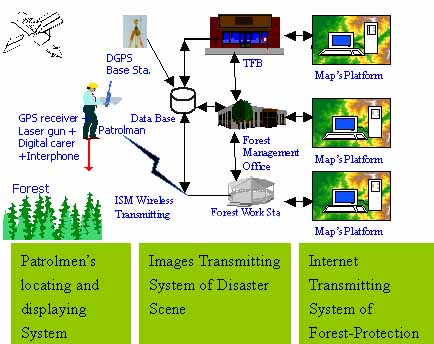
Fig 5 System Structure Chart
The report of the can be inquired and transmitted by.
 |
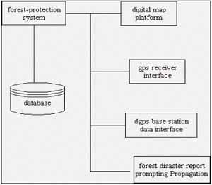 |
| Fig.6 Hand-Held GPS receiver | Fig. 7 system interface diagram |
The System Functions
This research performs the whole system to an executive file, which is operated independently. This system can be carried to install in any computer or Notebook computer. The following functions are included:
The Functions of Digital Map
Digital maps operate the system mainly. The digital map has the followed functions:
The Overlay of Map Layers
At anytime, the system combine forest topographies and forest cadastral maps as basic map, and then join in the administrative district map (Fig 8), hydrographic map, gradient map, imaging map, forest patrol-trail map (show as Fig 9) and forest calamity place coordinates etc, to construct an integrated GIS on the map layers for rescuing.
Basic Operation
The Basic functions of digital map are enlargement, reduction, displacement and revolution.
Information Inquiring
While clicking mouse on digital map screen, the system will display the clicked point interrelated information immediately, or one can key-in some data in inquiry item to filtrate the place and information which is required.
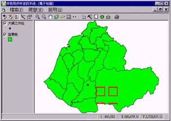
Fig.8 Administrative district map
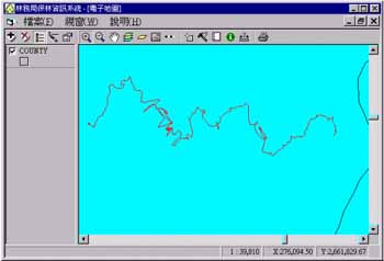
Fig. 9 Forest patrol-trail map
Map Printing
Printing the map in needed scale from plotter for analyze and consulting.
The Sub-system Function for Forest Patrol
The Essential Maintenance Data of Forest Patrolmen
Includes the ID, name, department of forest patrolmen, which would be identify and match the transmitted coordinates.
The Data Receiving of Portable GPS Receiver
The system provide two ways to get GPS data, one can immediately transmit the coordinates information which obtain from GPS receiver to forest workstation computer by radio modem, or download GPS data to computer from GPS receiver directly, when coming back to the office.
The Sub-system Function of Forest Disaster Prompting Propagation
- The Forest Disaster Prompting Propagation Data Maintaining
This operation includes forest disaster information, calamity region coordinates, instant scene pictures etc. The collecting information will be distinguished in primary file and detailed files. The primary file record essential information of calamity region, the detailed files record post-conduction after forest calamity. - The Forest Disaster Prompting Propagation Data
Transmitting
This system compress recorded files to transmit the data by Internet or compact disks. - The Identification Number Maintenance of Forest Disaster
This operation includes each type of forest disaster identification number.
- The Forest Disaster Prompting Propagation Data Maintaining
This operation includes forest disaster information, calamity region coordinates, instant scene pictures etc. The collecting information will be distinguished in primary file and detailed files. The primary file record essential information of calamity region, the detailed files record post-conduction after forest calamity. - The Forest Disaster Prompting Propagation Data Transmitting
This system compress recorded files to transmit the data by Internet or compact disks. - The Identification Number Maintenance of Forest Disaster
This operation includes each kind of forest disaster identification number.
This research project intent to promote the positioning accuracy, to establish a DGPS base station in Tahu Forest Work Station, receiving GPS message for whole time in everyday, and link with main system, so get the better differential correction value in computer. While hand-held GPS receiver's data of the patrolman has been linking to computer, the patrolling trail correction data has been done automatically.
Before establishing GPS base station, the base station setup the Leica system 300 GPS receiver, in the mean while also setup same model instrument in 5 known coordinate control point located around the base station within 3 kilometers, while performing static GPS surveying more than one hour, then post-process the GPS observations with Leica Ski software to get the local coordinate of Tahu base station.
Web inquiring forest calamity
Through the network to display the forest calamity, then establishing the common sense of protect forest.
Forest calamity scene real time transmitting
This research employ 2000 series, 2.4-2.4835GHz ISM frequency band local radio network (Industrial Science Medicine Frequency Band). The transmitting speed reaches 2 Mbps, even if transmitting place is far as 25 km, still can reaches 1 Mbps.(1999) This equipment transmission can provide more economical, tolerable than cable network. It always proceed transmitting stable no matter how weather situation. So user can understand calamity situation from browser through network facilities.
When patroller propagate forest calamity, the control commander instantly dispatch
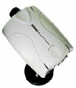
Van rescuing troops. The rescuer take forest calamity photo with AXIS 2100 digital camera (Fig. 10). The captured images are compressed to ZIP files with JPEG file type, transmitting to the nearest T1 network control center of forest management office by OMNI-Directional Antenna, WLD2000SA Wireless LAN Unit. The control commander can understand forest calamity development area and rescuing situation with browser software in computer.
Intent to develop effectively radio local network benefit, this research just run an enterprise investigate on-the-spot to choose 3 proper places as relay-station in Tahu region, will key-in coordinates and jurisdiction region to setup its data base. Then if it is successful to carry out the functions of display, inquiring, transmission, etc presently. This system will be an established basis for forest calamity relay station in future
 |
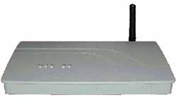 |
| Fig, 10 AXIS 2100 Digital Camera | Fig.11 WLD2000SA Wireless Connector |
Conclusion
- This research had run an demonstration in Tahu Work Station, employ palm GPS receiver just proceed simple operating procedure, to record patrolling trail and time, effectively improve management.
- This system posse completes function to easily operating.
- This system display or inquire patroller trail, effectively modify and manage patrolling route, completely eliminate patrolling blind angle.
- Ordinarily every patroller possess one GPS receiver displaying Chinese, while finding forest calamity in patrolling, recording calamity place coordinate and setup identified number, immediately transmitting calamity place coordinate, area, forest plantation, scene image to control commander with laser range finder, digital camera and, micro wave wireless radio for making a strategic decision.
- This system process receiving GPS message to record patrolling trail, forest identification number, extend inspecting forest administration to fulfill investigating national forest information.
- This system can improve management efficiency for forest administration; the executing achievement can be as a reference for revising policy.
- TFB (1998), Forest Protection, Briefing of TFB, P.16~21.
- Yang, L.S., Wu,C.M. (1998)E-Map Design, Cartography Conference, P.58-67.
- Shih,P.H., (1997) Geographic Information Systems,P.63~65
- Chung,L.K., (1999) °The Evolution of GIS,P.7.2~7.30 °
- Lieu, J.Y., (1993) The Principles and Applications of GPS, P163~164
- Jeng. C.L., (1999) The Fundamentals and Applications of GPS, P197~198
- Lee, C.T., (1999) The Introduction of Internet, P23~24
- Chou,T.Y.,Cheng, S.P., (1995) The Study of Real Time Vehicle Navigation & Tracing System, The 14th Conference of Surveyor Engineering & Application,P.159-172 °
- Steve Dye, Dr. Frank Baylin, (1997) ,The GPS Manual Principles and Application, P.143-144
- Chen,H.Y.,1996,.4, Decision Support for Agricultural Land Management, The Second International Symposium on Systems Approaches for Agriculture Development, IRRI,.Los Banos,.Philippines,.13P °
- Chou Tien-yin, Yen Mei-lin, Chen Cheng-jane, 1995, 5, Land Use Monitoring and Management for DerChi Reservoir Watershed, Hong Kong University Geoinformatics '95 Hong Kong.