| GISdevelopment.net ---> AARS ---> ACRS 2000 ---> Image Processing |
The Analytic of Remotely
Sensed Digital Image
Li Xianhua1,2,4, Zhang Dengrong1, Yu Gelong3, Lin Hui4,Shihuosheng4
(Zhejiang University, Hangzhou, 310027)1
(Chinese Eastern Normal University, Shanghai 260032)2
(Agricultural Remote Sensing Center of Sichuan Province)3
(Hongkong Chinese University)4
Li Xianhua1,2,4, Zhang Dengrong1, Yu Gelong3, Lin Hui4,Shihuosheng4
(Zhejiang University, Hangzhou, 310027)1
(Chinese Eastern Normal University, Shanghai 260032)2
(Agricultural Remote Sensing Center of Sichuan Province)3
(Hongkong Chinese University)4
Abstract
A method to disintegrate digital remotely sensed image is discussed in this paper. By which the information in original remotely sensed data can be disintegrated point by point into three components--solar direct illuminance (SDI), sky-scattering illuminnce (SSI) and atmospheric path radiance( APR). Because it is the result of the interaction of the natural spectral components with ground features and the atmosphere, the three components images play a more powerful role than the normal original remotely sensed data in the quantification inversion research of ground radiation energy, atmospheric environment condition, and remote sensing image pattern recognition.
Key Word: Remote Sensing, Digital Image, Analytic
1. Introduction
1The concept of image disintegration is widely used in remotely sensed digital image processing such as: to disintegrate panchromatic image into different band image according to spectral wavelength, to disintegrate image into high and low frequency parts by filter, to disintegrate image into the sum of wave element by Fourier transform and wavelet analysis Wavelet, and the mixed pixel disintegration etc…They are all effective method in remotely sensed image sensed image into three respective component images representing solar illuminance, sky-scattering illuminance and atmospheric brightness by the support of GIS will be discussed in the following.
2. Interaction of Terrain, Natural Spectrum and Remotely Sensed Data
The quantification relationships between remotely sensed data and natural spectrum and composition of ground pixel, and the quantification relationships between remotely sensed value of different band component pixel and slope direction and gradient of ground surface of the pixel is the bases of disintegration of remotely sensed digital image.
2.1 The quantitive relationships between remotely sensed data and ground illuminance and pixel natural spectral illuminance.
The quantitative relationships are as following:
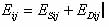
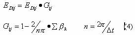
where, K is the intrinsic ration in MSS system; and
and  is the ground spectral reflectance and
the atmospheric spectral transmissivity of the pixel respectively;
is the ground spectral reflectance and
the atmospheric spectral transmissivity of the pixel respectively;  is the pixel's solar illuminance
(PSIOP);
is the pixel's solar illuminance
(PSIOP);  is sky-scattering
illuminance (SSI);
is sky-scattering
illuminance (SSI);  is atmospheric
brightness (AB);
is atmospheric
brightness (AB);  and
and  are the corresponding remotely sensed
component value of the pixel respectively.
are the corresponding remotely sensed
component value of the pixel respectively.
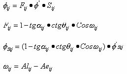
2.2 The Quantitative Relationship Between the Pixel's Illuminances on the Slope and Respective Remotely Sensed Data
2.2.1 The Relationship between PSIOS and the respective Remotely Sensed Data
As shown in Figure 1, given a solar elevation, the solar point-blank luminous flux on the pixel's slope aspect, , is
, is  times of the solar point-blank luminous
flux on the horizontal projective aspect,
times of the solar point-blank luminous
flux on the horizontal projective aspect,
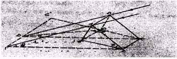
Fig 1 The solar direct luminous flux on the slope aspect and the horizontal projective aspect
 (2)
(2)
Where, and
and  are respectively the pixel's ground
sloped angle, the solar elevation, the slope aspect and the sun azimuth
angle. Because there is relationship between pixel's slope aspect area
are respectively the pixel's ground
sloped angle, the solar elevation, the slope aspect and the sun azimuth
angle. Because there is relationship between pixel's slope aspect area
 and its horizontal projective
aspect area as following.
and its horizontal projective
aspect area as following.
We have the pixel's slope aspect luminous as:
Where is the pixel's
horizontal projective aspect luminous.
is the pixel's
horizontal projective aspect luminous.
And the pixel's slope aspect remotely sensed data value can be:
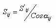
2.2.2 The pixel's sky-scattering light illuminance on the slope aspect and its remotely sensed data value
As shown in Figure 2[2], a given pixel there have relationslhip between the pixel's sky light
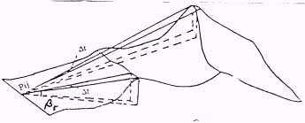
Fig 2 The sky-scattering light shielded model by the surrounding terrain factors
illuminance on the slope aspect where Pij is
shielded by the suround landform and the pixel's sky light illuminance
where Pij is
shielded by the suround landform and the pixel's sky light illuminance
 where Pij is on flat
and widen terrain condition as:
where Pij is on flat
and widen terrain condition as:
Where, is the terrain-shielding angle of pixel
in the Kth aspect on a digital topographic map.
is the terrain-shielding angle of pixel
in the Kth aspect on a digital topographic map.
 is the azimuth increment.
In a similar way, there have:
2.2.3 The quantitative relationship of pixel's remotely sensed components between solar direct light and sky-scattering light illuminance
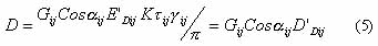
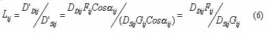
The quantitative relation between pixel's remotely sensed components of solar direct light Dij and remotely sensed components of sky-scattering light illuminance Dij depends on the ratio of the horizontal projective aspect component of the sky-scattering light illuminance (E'ij) to the solar direct light (E'Sij) on the pixel's slope aspect surface (What is called scatter to direct ratio(SDR)).
According to (4) and (5) equation, we have,
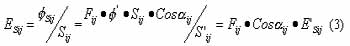
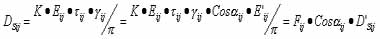
3 The scatter to direct ratio(SDR) and the remotely sensed data value of atmospheric path radiance (APR)
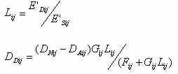
In horizontal direction, the spatial change of sky-scattering light illuminance to the solar direct light (SDR) and he remotely sensed data value of atmospheric path radiance, have such properties as low-frequency and continuousness. Thus, the horizontal component of a certain pixel point can be interpolated by digital surface simulation. According to the distance-weighted interpolation algorithm, We can get the following expression:
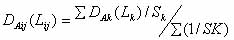
Where DAK and LK are seperately defined as the satellite-ground synchronous observational pixel's remotely sensed data value of APR and SDR on the =ground surface in Kth small region; And Sk is the distance from the Kth observation point to the pixel
The compute algorithm of the remotely sensed data value of pixel Pk of APR is presented in Reference[3]:
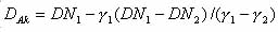
Where, DN1, DN2 respectively refers to the pixel's remotely sensed data value of two different neighboring ground features, is their reflectivity.
And n is the number of actual-measured discrete ground observation points.
is their reflectivity.
And n is the number of actual-measured discrete ground observation points.
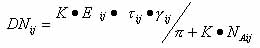
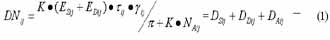
4 Disintegration of pixel's remotely sensed data value
As we review equation (1) and equation(6), we can get the following expression that presents the relationship between the original remotely sense data and the
remotely sensed component of solar direct light
and the
remotely sensed component of solar direct light  of pixels;
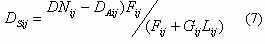
In the similar way, the relationship between the original remotely sensed data (DNij) and the remotely sensed component of sky-scattering light illuminance DDij of pixels

Suppose the Band 4 original data value on a remotely sensed image are as follows;
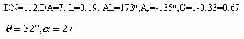
Then :

Because pixel's remotely sensed data value of APR(DAij) depend on the atmospheric conditions and have no relationship with the ground features, the expression (DNij-DDij)in the equations is the atmospheric correction in traditional remotely sensed image processing.
For the sake of simplification, all above discussion is based upon the assumption that the surface is of Lambertian feature. But the conclusive expressions are also appropriate for the non-Lambertian surface, because the coefficients, Fij, Gij and Gij in the equation are computed directly based on the equimultiple change of the same pixel's ground irradiance (the directions of incidence and reflection are same either on natural ground surface or on horizontal ground surface), don't involve the directional reflection.
5.Composition and Decomposition of Remotely sensed digital image
Being Have the expression of pixel's remotely sensed data value with the three components of the solar direct light, sly-scattering light illuminance and atmospheric path radiance, we can now resolve the original remotely sensed digital image light illuminance (SSI) image and atmospheric path radiance(APR) image.
Suppose the original remotely sensed image is defined as:
The solar direct illuminance (SDI) image is defined as:
The sky-scattering light illuminance (SSI) image is defined as:
The atmospheric path radiance(APR) image is defined as:
then
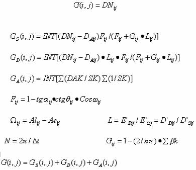
Where i=1,2…….,n; j=1,2…..,m.
The image composition and decomposition can be realized by the above calculation point by point.
For the sun light is a kind of strong-directional non-polarized light, the SDI image can be used in research of direction reflection of ground surface features. The sky-scattering light is anisotropic random polarized, its corresponding remotely sensed image, which is free from shadow disturb, can be applied in research of computer identification and classification. The remotely represents the difference of atmospheric environment monitoring.
In conclusion, the different kind of components of natural light shows different characters. The analytic of remotely sensed image plays a unique powerful role in the research of remote sensing mechanism, and ground surface radiant energy quantitative analysis.
Reference
A method to disintegrate digital remotely sensed image is discussed in this paper. By which the information in original remotely sensed data can be disintegrated point by point into three components--solar direct illuminance (SDI), sky-scattering illuminnce (SSI) and atmospheric path radiance( APR). Because it is the result of the interaction of the natural spectral components with ground features and the atmosphere, the three components images play a more powerful role than the normal original remotely sensed data in the quantification inversion research of ground radiation energy, atmospheric environment condition, and remote sensing image pattern recognition.
Key Word: Remote Sensing, Digital Image, Analytic
1. Introduction
1The concept of image disintegration is widely used in remotely sensed digital image processing such as: to disintegrate panchromatic image into different band image according to spectral wavelength, to disintegrate image into high and low frequency parts by filter, to disintegrate image into the sum of wave element by Fourier transform and wavelet analysis Wavelet, and the mixed pixel disintegration etc…They are all effective method in remotely sensed image sensed image into three respective component images representing solar illuminance, sky-scattering illuminance and atmospheric brightness by the support of GIS will be discussed in the following.
2. Interaction of Terrain, Natural Spectrum and Remotely Sensed Data
The quantification relationships between remotely sensed data and natural spectrum and composition of ground pixel, and the quantification relationships between remotely sensed value of different band component pixel and slope direction and gradient of ground surface of the pixel is the bases of disintegration of remotely sensed digital image.
2.1 The quantitive relationships between remotely sensed data and ground illuminance and pixel natural spectral illuminance.
The quantitative relationships are as following:
where, K is the intrinsic ration in MSS system;
and is the ground spectral reflectance and
the atmospheric spectral transmissivity of the pixel respectively; is the pixel's solar illuminance
(PSIOP); is sky-scattering
illuminance (SSI); is atmospheric
brightness (AB); and are the corresponding remotely sensed
component value of the pixel respectively. 2.2 The Quantitative Relationship Between the Pixel's Illuminances on the Slope and Respective Remotely Sensed Data
2.2.1 The Relationship between PSIOS and the respective Remotely Sensed Data
As shown in Figure 1, given a solar elevation, the solar point-blank luminous flux on the pixel's slope aspect,
, is times of the solar point-blank luminous
flux on the horizontal projective aspect, Fig 1 The solar direct luminous flux on the slope aspect and the horizontal projective aspect
(2)Where,
and are respectively the pixel's ground
sloped angle, the solar elevation, the slope aspect and the sun azimuth
angle. Because there is relationship between pixel's slope aspect area
and its horizontal projective
aspect area as following.
We have the pixel's slope aspect luminous as:
Where
is the pixel's
horizontal projective aspect luminous. And the pixel's slope aspect remotely sensed data value can be:
2.2.2 The pixel's sky-scattering light illuminance on the slope aspect and its remotely sensed data value
As shown in Figure 2[2], a given pixel there have relationslhip between the pixel's sky light
Fig 2 The sky-scattering light shielded model by the surrounding terrain factors
illuminance on the slope aspect
where Pij is
shielded by the suround landform and the pixel's sky light illuminance
where Pij is on flat
and widen terrain condition as: Where,
is the terrain-shielding angle of pixel
in the Kth aspect on a digital topographic map. is the azimuth increment. In a similar way, there have:
2.2.3 The quantitative relationship of pixel's remotely sensed components between solar direct light and sky-scattering light illuminance
The quantitative relation between pixel's remotely sensed components of solar direct light Dij and remotely sensed components of sky-scattering light illuminance Dij depends on the ratio of the horizontal projective aspect component of the sky-scattering light illuminance (E'ij) to the solar direct light (E'Sij) on the pixel's slope aspect surface (What is called scatter to direct ratio(SDR)).
According to (4) and (5) equation, we have,
3 The scatter to direct ratio(SDR) and the remotely sensed data value of atmospheric path radiance (APR)
In horizontal direction, the spatial change of sky-scattering light illuminance to the solar direct light (SDR) and he remotely sensed data value of atmospheric path radiance, have such properties as low-frequency and continuousness. Thus, the horizontal component of a certain pixel point can be interpolated by digital surface simulation. According to the distance-weighted interpolation algorithm, We can get the following expression:
Where DAK and LK are seperately defined as the satellite-ground synchronous observational pixel's remotely sensed data value of APR and SDR on the =ground surface in Kth small region; And Sk is the distance from the Kth observation point to the pixel
The compute algorithm of the remotely sensed data value of pixel Pk of APR is presented in Reference[3]:
Where, DN1, DN2 respectively refers to the pixel's remotely sensed data value of two different neighboring ground features,
is their reflectivity.
And n is the number of actual-measured discrete ground observation points.
4 Disintegration of pixel's remotely sensed data value
As we review equation (1) and equation(6), we can get the following expression that presents the relationship between the original remotely sense data
and the
remotely sensed component of solar direct light of pixels; In the similar way, the relationship between the original remotely sensed data (DNij) and the remotely sensed component of sky-scattering light illuminance DDij of pixels
Suppose the Band 4 original data value on a remotely sensed image are as follows;
Then :
Because pixel's remotely sensed data value of APR(DAij) depend on the atmospheric conditions and have no relationship with the ground features, the expression (DNij-DDij)in the equations is the atmospheric correction in traditional remotely sensed image processing.
For the sake of simplification, all above discussion is based upon the assumption that the surface is of Lambertian feature. But the conclusive expressions are also appropriate for the non-Lambertian surface, because the coefficients, Fij, Gij and Gij in the equation are computed directly based on the equimultiple change of the same pixel's ground irradiance (the directions of incidence and reflection are same either on natural ground surface or on horizontal ground surface), don't involve the directional reflection.
5.Composition and Decomposition of Remotely sensed digital image
Being Have the expression of pixel's remotely sensed data value with the three components of the solar direct light, sly-scattering light illuminance and atmospheric path radiance, we can now resolve the original remotely sensed digital image light illuminance (SSI) image and atmospheric path radiance(APR) image.
Suppose the original remotely sensed image is defined as:
| G(i,j) | i=1,2,.....,n; | j=1,2,.....n. |
The solar direct illuminance (SDI) image is defined as:
| Gs(i,j) | i=1,2,.....,n; | j=1,2,.....n. |
The sky-scattering light illuminance (SSI) image is defined as:
| GD(i,j) | i=1,2,.....,n; | j=1,2,.....n. |
The atmospheric path radiance(APR) image is defined as:
| GA(i,j) | i=1,2,.....,n; | j=1,2,.....n. |
then
Where i=1,2…….,n; j=1,2…..,m.
The image composition and decomposition can be realized by the above calculation point by point.
For the sun light is a kind of strong-directional non-polarized light, the SDI image can be used in research of direction reflection of ground surface features. The sky-scattering light is anisotropic random polarized, its corresponding remotely sensed image, which is free from shadow disturb, can be applied in research of computer identification and classification. The remotely represents the difference of atmospheric environment monitoring.
In conclusion, the different kind of components of natural light shows different characters. The analytic of remotely sensed image plays a unique powerful role in the research of remote sensing mechanism, and ground surface radiant energy quantitative analysis.
Reference
- 1.Li Xianhua, Correction of Terrain Influence in remote sensing Information, Journal of Topography, May, 1986,15(2)
- 2.Li Xianhua, Calculation and emendation of diffusion irradiant energy of Remotely sensed Data on upland condition, Remote sensing Technique and Application,Mar,1992,7(1).
- 3 Li Xianhua, Inversion Calculation of the Pixel's Surface
Reflectivity of the remotely sensed data , Environmental Remote Sensing,
Dec, 1993,8(4)