| GISdevelopment.net ---> AARS ---> ACRS 2000 ---> Oceanography |
The Use of SeaWiFS Satellite
Data For Ocean Colour Determination In Fisheries Application
Mohd Ibrahim Seeni Mohd and
Tadris Ahmad
Department of Remote Sensing,
Faculty of Geoinformation Science and Engineering
Universiti Teknologi Malaysia,
81310 Skudai, Johor, Malaysia
Tel : (607) 5502969 Fax : (607) 5566163
E-mail : mism@fksg.utm.my , amir_ahmad@lycos.com
Keywords : SeaWiFS satellite data, normalised
water leaving radiance(nLw) at 443nm, fish distribution, concentration of
chlorophyll Department of Remote Sensing,
Faculty of Geoinformation Science and Engineering
Universiti Teknologi Malaysia,
81310 Skudai, Johor, Malaysia
Tel : (607) 5502969 Fax : (607) 5566163
E-mail : mism@fksg.utm.my , amir_ahmad@lycos.com
Abstract
Several studies have explored the possibility of using remote sensing data for marine and oceanography applications in Malaysia. These include satellite bathymetry, suspended sediment and sea bottom features mapping. Remote sensing of ocean colour in the coastal zone is currently used to map a chlorophyll concentration. Through analysis of satellite data over long time of periods, a suitable algorithm can be test and evaluated in responsed to different seasons and environment. This research intends to study on the algorithm development using SeaWiFS data with the hope to improve the results. In - situ data were collected at the time of satellite pass in Terengganu coastal area during 20 to 22 June 2000. This data will be used with SeaWiFS data acquired during this period to calibrate and validate relevant algorithm. The preminilary result shows the correlation between normalised water leaving radiance (nLw) at 443 nm and chlorophyll concentration. At this wavelengths, as chlorophyll concentration increases, absorption will also increases. The R--squared value for the correlation of above parameters is 0.96. Further investigation will be carried out to evaluate the RMSE between the in-situ measurement and the chlorophyll concentration calculated using the SeaWiFS data. This research would be beneficial to the Fisheries Department to determine potential fishing grounds.
Introduction
The research includes the identification of regression coefficient through a modification of existing algorithm which is suitable to Malaysia coastal waters. The suitable algorithms will be used to estimate the concentration of chlorophyll using the satellite data. Time series satellite images are required for the analyses with in - situ data obtained simultaneously . This quantitative technique can be used to monitor the variability of chlorophyll spatially and temporally.
The study will be conducted in the coastal waters of Terengganu located between 5° - 6°30` N and 102° - 104° E ( Figure 1 ). The east coast of Peninsular Malaysia has a complex oceanic characteristics due to the monsoon winds which have a significant effect on the chlorophyll distribution.
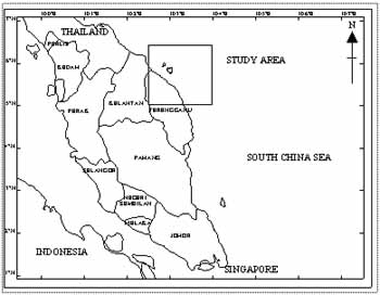
Figure 1: Location of map study area.
Materials and Methods
This study was carried out using SeaWiFS satellite data which was taken simultaneously with in - situ measurement. SeaWiFS data was supplied by HRPT (High Resolution Picture Transmission) station at National University of Singapore. The raw level 1A data was processed using SEADAS image processing to extract normalised water leaving radiance (nLw). The influence of molecular scaterring from atmosphere is corrected by employing an atmospheric correction procedured, referred as Gordon and Wang algorithm( Wang 1994 ). It is necessary to normalised the radiance by the incoming solar irradiance to eliminate sun zenith angle effects and atmospheric effects.
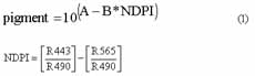
Chlorophyll concentration was quantitatively estimated using an algorithm proposed by Robert Frouin from Scripps Institute for Oceanography. However the algorithm has been modified prior to regional variability.
C = phytoplankton concentration
A and B = regression coefficient ( site - spesific)
The algorithm above then has been iterated to retrieve the regression coefficient.
Results
SeaWiFS data taken on 20 June 2000 over Terengganu coast of Malaysia was available on compact disc. Sea - truth of chlorophyll had been taken at 4 stations by Unipertama 7 and Unipertama 3 ships .
The values of normalised water leaving radiance at several bands corresponding to chlorophyll concentration are given in table 1.
| Station | nLw 443 | nLw 490 | nLw 555 | Chlorophyll |
| 1 | 0.285 | 0.685 | 0.617 | 0.146 |
| 2 | 0.526 | 1.025 | 0.678 | 0.138 |
| 3 | 0.741 | 1.254 | 0.895 | 0.117 |
| 4 | 0.749 | 0.815 | 0.405 | 0.121 |
| 5 | 0.195 | 0.496 | 0.323 | 0.075 |
| 6 | 0.155 | 0.413 | 0.237 | 0.089 |
| 7 | 0.109 | 0.326 | 0.177 | 0.113 |
| 8 | 0.251 | 0.454 | 0.230 | 0.063 |
Figure 2 presents a relationship between the normalised water leaving radiance ( nLw) at 443 nm and chlorophyll . When the chlorophyll concentration increase, there is more absorption in the blue and the nLw at 443 nm should decrease.
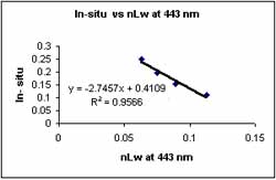
Figure 2: Relation between chlorophyll concentration and normalised water leaving radiance at 443 nm ( blue wavelength) observed by Unipertama 7 cruise.
Figure 3 allows a comparison of chlorophyll determined from in - situ with the chlorophyll concentration as estimate from the SeaWiFs data. Results show that the chlorophyll concentration derived from satellite image is generally larger than that derived from in-situ measurement at some stations. The CAL-P6 algorithm uses a sixth-order polynomial of the ratio of radiances at 490 nm and 555 nm proposed by Kahru and Mitchell (1999) also show a significant overestimation by SeaWiFS at high chlorophyll concentration.
The details about comparison of the value are shown in table 2. The root-mean-square error (RMSE) of chlorophyll concentration is about 0.050 mgm-3. Validation of the SeaWiFS-derived chlorophyll values with 7 concurrent in - situ measurements showed high correlation r2 = 0.75.
| Station | Chlorophyll concentration from in-situ measurement | Chlorophyll concentration estimated by satellite |
| 1 | 0.146 | 0.080 |
| 2 | 0.138 | 0.083 |
| 3 | 0.117 | 0.104 |
| 5 | 0.075 | 0.114 |
| 6 | 0.089 | 0.116 |
| 7 | 0.113 | 0.116 |
| 8 | 0.063 | 0.118 |
Figure 3: A good relationship between the sea truth measurement and satellite data for estimating chlorophyll concentration value( r2 = 0.75).
Conclusions
Site specific algorithm have been derived from the nLw at 443, 490, 555 using modified Frouin algorithm . The regression coefficient for A and B are 0.22 and 0.89 respectively. Although the results are encouraging , further in - situ measurements need to be done to compare the variability of the chlorophyll distribution before and after the monsoon seasons. The avaibility to relate chlorophyll concentration to optical characteristic is seriously impaired by the relatively small quantity of coincident in - situ measurement during satellite overpass.
In general, chlorophyll with high concentration was distributed around the coast line compared to area far from the coast. However from the study some of the area which is far from the coast has a high chlorophyll concentration. This phenomena happen due to a strong current that move the chlorophyll patchines from coastal area. Moreover the effect of upwelling is more marked when upwelling occurs on coastlines with a continental shelf. When upwelling occurs along a coastline, the upwelled water which carry the floating chlorophyll tend to move away from the coast. The monsoon winds have a significant effect on the current circulation in the South China Sea. According to Nasir et al. 1996, from July to September 1996, the net current flow near the coast of Kuala Terengganu is toward the southwest direction.
The movement of the current can be detected clearly when observe the map of chlorophyll distribution using satellite image( Figure 4). The result of the study reveals that the chlorophyll concentration pattern of 0.104 - 0.129 mgm-3 can be used as a tracer for the current movement.
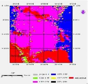
Figure 4: Chlorophyll concentration distribution estimated using SeaWiFS satellite data.
Acknowledgements
The authors would like to thank the SeaWiFS Project ( Code 970.2 ) and Distributed Active Archive Center (Code 902 ) at the Goddard Space Flight Center,Greenbelt MD 20771 for the production and distribution of these data respectively. These activities are sponsored by NASA's Mission to Planet Earth program. Thanks are also due to CRISP of NUS for supplying LAC data. The contribution from technical staff of Universiti Teknologi Malysia and Universiti Putra Malaysia Terengganu are duely acknowledge.
References
- Fougnie, B., Deschamps, D. Y. and Frouin, F.(1999)."Vicarious Calibration of the POLDER Ocean Colour Spectral Bands using In - situ Measurement." IEEE Transactions on Geoscience and Remote Sensing. 37 (3). 1567-1574
- Kahru, M. and Mitchell, B.G. (1999). "Empirical chlorophyll algorithm and preliminary SeaWiFS validation for the California Current." International Journal Of Remote Sensing. 20. 17.
- Nasir, M. S., Camerlengo, A. L. & Wan, H. K. (1996). "Coastal Current in the Northern Region of the East Coast of Peninsular Malaysia." Sains Malaysiana. 26 (2) .5-14.
- Wang, M. and Gordon , H . R . ( 1994). "A Simple, moderately accurate, atmospheric correction algorithm for SeaWiFS." Remote Sensing of Environment. 50. 231 - 239.