| GISdevelopment.net ---> AARS ---> ACRS 2000 ---> Mapping from Space & GPS |
Use of digital terrain
modeles for the infrastructure development in sri lanka.
Nihal
WIJESEKERA
Senior Lecture, Superintendent of Surveys
Institute of Surveying & Mapping, Diyatalawa
Tel: +94-57-31735 Fax: +94-57-22004
E-mail: ism_surv@sri.lanka.net
SRI LANKA
Keywords : Terrain,
InfrastructureSenior Lecture, Superintendent of Surveys
Institute of Surveying & Mapping, Diyatalawa
Tel: +94-57-31735 Fax: +94-57-22004
E-mail: ism_surv@sri.lanka.net
SRI LANKA
ABSTRACT :
Digital Terrain Models (DTMs) have become a major constituent of geographical information processing. DTMs facilitate to model, analyse and display phenomena related to topography or similar surfaces. This paper presents an approach to use those capabilities in DTMs for the infrastructure development in Sri Lanka. The different techniques of data capturing methods are given, with a comparison, providing opportunity to select the best method that appropriate for the requirement. The theoretical basis and a number of DTM packages are described and an attempt is made to determine how best such system can cover many of the practical requirements. Some applications are mentioned where they have particular features that relate to the theme of the paper.
Introduction
A digital terrain model (DTM) can be described as a three - dimensional representation of a terrain surface consisting of X, Y, Z coordinates stored in digital form. It includes not only heights and elevations but other geographical elements and natural features such as rivers, ridge lines, etc. With the increasing use of computers in engineering and the development of fast three-dimensional computer graphics the DTM is becoming a powerful tool for a great number of applications in the earth and the engineering sciences.
Data Collection For Digital Terrain Modelling
The acquisition of accurate three-dimensional coordinates which represent the surface of the Earth is a vital stage in the process of terrain modelling. The raw data of the DTM can be captured by a number of different techniques. The particular technique used will depend on factors such as:
- The size of the area to be surveyed
- Data accuracy
- Type of information which will eventually be extracted from the model
- Availability of resources
- Ground survey methods
- Photogrammetric methods
- Graphics digitizing methods
Ground surveys could be done with computer aided systems which may be coupled to field instruments, available from all the major manufactures, such as Kern, Zeiss Wild, Sokkia etc. Total station instruments such as Elta-2, Wild, Sokkia Set 2, Leica are common instruments used for data capturing in ground surveying method.
Since ground survey data tend to be very accurate, the accuracy of the resulting DTM is very high. Hence, it is most suitable for the small area site planning and designing. However, as this particular data collection technique is relatively time consuming and expensive its use is limited to small areas.
Photogrammetric Methods
Photogrammetric data capturing is widely used for large area projects, especially in rough terrain. Photogrammetric methods based on the use of stereoscopic interpretation of aerial photographs or satellite imagery (e.g. from the French SPOT Satellites), using suitable photogrammetric equipment such as manual or analytical stereo plotters. The accuracy of the resulting DTM depending on the sampling method and imagery that are used. The resulting DTM accuracy will be in the range of medium to high. Photogrammetric data capture is used in large engineering projects such as dams, and roads as well as nation wide data collection.
Graphics Digitizing Methods
The third alternative is the use of a very large number of topographic maps already existed in printed form. These maps are converted into a digital format by digitization. When the topographic maps are in digital format, digital map data generally occur as string or series of strings of (X,Y) coordinates with an associated Z value for the contour level.
An example of a DTM (Figure 2) constructed from an existing contour map (Figure 1) is shown below.
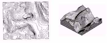 | |
| Figure 1 Contour map |
Figure 2 DTM of the area shown in Figure 1 |
The existing small-scale topographic maps e.g.1 inch sheets (1:63360) and 1:50000 scale maps produced by the Survey Department of Sri Lanka can be used to create DTMs with low accuracy. However, as long as users are aware of this limitation, this lower-quality data is quite acceptable in regional planning, landscaping, visualization, simulation, civil engineering projects and reconnaissance studies.
However, since large area coverage is achieved relatively at a low cost, existing topographic maps provide a compromise method of obtaining DTMs for use at medium or small scales.
Table 1 presents the three main methods which can be used to acquire the elevation data and applications of terrain models created at different scales.
|
|
|
|
|
|
|
|
Total or semi-total station | Very high | Limited to specific sites | Small area site Planning and design |
|
|
Stereoplotting Machine (with or without correlators |
|
Large area projects,especially in rough terrain |
|
|
|
|
Low: derived from contours on medium and small scale topographic maps | Nationwide at small scales | Aircraft simulators, Landscape Visualization, landform Representation, military battlefield simulation |
Table 1: Sources of DTM data and applications
Construction Of Digital Terrain Models
After capturing of raw data sets, to construct a comprehensive DTM, it is necessary to establish the topological relations between the elements, as well as an interpolation model to approximate the surface behaviour. In order to do that a very large number of programme packages have been devised and written for terrain modelling and it's applications.
The general classification of terrain modelling software packages in surveying and civil engineering is illustrated in figure 3.
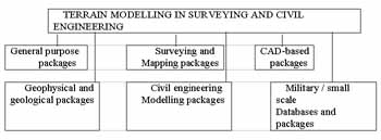
Figure 3 Classification of terrain modelling software packages in surveying and civil engineering.
Applications
Terrain modelling is applied as a solution to a wide range of problems in the field of surveying and mapping, geology, civil and military engineering. Being Sri Lank is a developing country, much more emphasis has to be made to identify the low cost methods in infrastructure development in the country.
Terrain models which can be created by using photogrammetry and existing maps are less expensive Hence, those techniques are ideal tools to solve problems in infrastructure development.
Feasibility Studies
Feasibility study is one of the main prerequisites of any major development project. Failure of feasibility study may be the failure in the entire project giving economical & environmental hazard to the country. Traditionally a feasibility study is done by manual data capturing techniques or by simply utilizing the skill and experience of the qualified experts. The method is highly time consuming and expensive.
Having generated a ground model of the proposed area, feasibility studies and environmental impact analysis can be performed automatically once the position of the proposed site is defined. Figure 4 illustrates the use of the technique to simulate the effect of a proposed highway on an existing ground model.
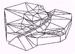
Figure 4 Simulated highway model created using the MTM Terrain modelling package
Communications Planning
In recent years use of telecommunication, radio and television, cellular and mobile telephones have increased in Sri Lanka.
The use of Terrain model data, in conjunction with computer analysis is widely use in many countries in this field. The applications are involved in the planning of communications network, rapid optimization of radio links, siting of transmitters, identification of complementary areas of coverage and prediction of areas subject to co-channel interface.
As lower accuracy DTMs could be generated with the help of photogrammetric and cartographic data capturing methods are quite suitable for the above, the method can be used in Sri Lanka to enhance the communication developments.
DTM Applications To Civil Engineering
Civil engineering is an important user of terrain modelling. The range of projects where the DTMs are used is almost endless, covering roads, railways, dams, reservoirs, canals, landscaping, land reclamation and mining, etc. The range of facilities included in the terrain modelling permits the survey and design of projects mentioned above. Apart from that, the suitable software (e.g. MOSS) can be used to produce sections, areas, volumes, setting-out information, triangulation of surfaces and contouring.
Land Settlement Programmes
Alienation of lands to the landless people is a common practice of any Government of Sri Lanka. The programme may be a small scale or a large settlement programme such as Mahaweli Development Scheme.
Settlements are done with the help of prepared plans known as Blocking Out Diagrams (BOD). (Figure 5) Traditionally these BODs are prepared by surveyors using ground survey methods considering only the topographical features available in the site.
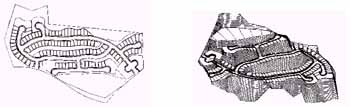 | |
| Figure 5 Blocking
Out Diagram |
Figure 6 DTM showing
the projection of design data |
Due to the lack of communication with other organizations such as Electricity Board, Water Board, Telecommunication Department, Road Authorities and non availability of proper data sets, it can be seen that is a delay in providing infrastructure facilities for many years.
After preparation of the DTM of the proposed area the design (BOD) can be incorporated in to the model using Surface Modelling Programs. (eg. HASP)
The resultant model (Figure 6) can be used as a data source and a tool for the Civil Engineering, Environmental and other organizations to solve their problems, as already discussed, to develop the area.
Conclusion
Terrain modelling is applied as a solution to a wide range of problems in the fields of surveying and mapping, and civil engineering. For the future, the use of terrain modelling methods will continue to develop and expand into other areas of activity. Hence, introducing the technique in Sri Lanka has vital importance, because it can be used as a tool in the process of development.
References
- Burrough, P.A., 1990, Principles of Geographical Information Systems For Land Resources Assesment. Clarendon Press, Oxford.
- Maguire, D.J.and Goodohild, M.F., 1992, Geographical Information Systems. Volume 1, Bath Press, Avon.
- Petrie, G.and Kennie, T.J.M., 1990, Terrain Modelling in Surveying and Civil Engineering. Whittles Publishing, London, p4, p26.