| GISdevelopment.net ---> AARS ---> ACRS 2000 ---> Landuse |
Urban planning and monitoring
changes using ER Mapper
Dr Abdullah Mah
Training & Applications Consultant
Earth Resource Mapping, Asia Pacific region
Dr Abdullah Mah
Training & Applications Consultant
Earth Resource Mapping, Asia Pacific region
With the rapid growth in population throughout the
world, it is crucial to have a well-concerted plan for urban expansion.
Satellite or Airborne images give Urban planners synoptic views of large
areas which allow them to lay plans for urban expansion effectively. Using
December, 1990 and February, 1997 SPOT Panchromatic and Multi-Spectral
imagery of the Sydney Metropolitan area, the paper demonstrates how to use
ER Mapper in processing those images for urban planning and to monitor
changes that took place over the 1990-1997 years.
Introduction
The study area is the Sydney Metropolitan area. SPOT Imaging Services Pty Ltd's permission to use the December, 1990 and February, 1997 SPOT Panchromatic and Multi-Spectral data of the Sydney Metropolitan area is much appreciated and acknowledged. The location map (Fig. 1) shown below covers most of the study area which is approximately 38 sq kms. The paper discusses rectification of the images, standardizing the atmospheric condition of the 2 dates imagery, change detection between the 2 dates SPOT Panchromatic and Principle Component number 1 of the 2 dates SPOT Multi-spectral imagery. A few small areas are selected to show the effectiveness of the change detection techniques applied on the 10 and 20 meters resolution SPOT Panchromatic and Multi-Spectral images.

Figure 1. Location map of the study area (Sydney Metropolitan area)
Processing
Rectification:
The June 1998 Orthocorrected SPOT Panchromatic image was used as the master dataset to rectify the December 1990 and February 1997 SPOT RAW images. Average RMS error of less than 0.5 is achieved for all the images (SPOT Panchromatic a RMS of 0.454 for 12/90 and 0.374 for 2/97 and SPOT Multi-Spectral 0.347 for 12/90 and 0.248 for 2/97). The common area of the 2 dates imagery was then subsetted for the study. The study area covers, Sydney in the East, Parramatta in the West, Hornsby in the North and just above Cronulla in the South (Fig. 1).
Standardizing the atmospheric condition:
The atmospheric condition was most likely to be different at the time the 2 images were taken, one in December, 1990 and the other in the February, 1997. To do change detection it is necessary to standardize the atmospheric condition of the two-date imagery. Bi-variant scattergram was used to find out the cut-off values that might have contributed by the atmosphere. The cut-off values were then used to standardize the atmospheric condition of the two-date images.
Change detection:
The recently developed Local Council Applications Wizard (LCAW) (Fig. 2) was used to carry out change detection of the Sydney Metropolitan area using the two dates SPOT Panchromatic and Multi-Spectral data. Though LCAW was developed for Local Councils to process Airphotos and Scanned maps, both Airphoto Panchromatic and SPOT Panchromatic are one band data. Similarly, both RGB Airphotos and SPOT Multi-Spectral data are 3 bands imagery. Hence, Change Detection (2 dates Airphoto Pan & Pan) and Change Detection (2 dates RGB & RGB) modules were used to carry our change detection of the 2 dates SPOT Panchromatic and Multi-Spectral data. The processing time of the change detection between the 2 dates SPOT Panchromatic was about 2 minutes and for the Multi-Spectral was about 3 minutes. Processing time for 2 dates Multi-Spectral data took longer because it uses Principle Component number one of the 3 bands Multi-Spectral data which requires statistic calculation of the datasets. All the processing steps are in-built into the LCAW and hence is very fast to process data and leaves a lot of time for the author to analyze the processed images.
Figure 2. Local Council Applications Wizard main menu window.
SPOT Panchromatic:
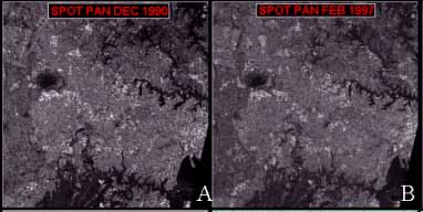
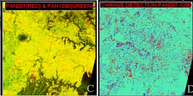
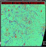
Images of the original SPOT Panchromatic of December, 1990, February, 1997, change detection using Red (Feb97) and Green (Dec90), change detection subtraction and division methods are displayed in Figure 3.
Figure 3. SPOT Panchromatic (Dec 90 & Feb 97) of Sydney Metropolitan area and change detections
Simple Red-Green combination change detection:
This is a very simple method to quickly check the changed areas by just using the Red gun for PanFeb97 and the Green gun for PanDec90. Where there are differences between the 2 dates imagery Red and Green colors are displayed and the areas where there are no differences Yellow color is displayed (Fig 3C). However, the method is only for visualization and changed areas cannot be mapped.
Change Detection - Subtraction method:
This method simply subtracts one date SPOT Pan from another (Feb97 Pan - Dec90 Pan). Using the Pseudocolor look-up-table the changed areas for the 2 dates SPOT Pan and the common areas can be mapped in three colors and changed areas can be mapped and can be converted to vector format. The changed areas of the 2 dates SPOT Pan are mapped as blue and red whereas the common areas are mapped and displayed in cyan color (Fig. 3D). The thresholds of the changed areas are defined by the step transformation where the changed areas are represented by the two extreme ends of the (Feb97 Pan - Dec90 Pan) histogram. The changed maps can then be verified with groundtruthing.
Change Detection - Division method:
This method simply divides one date SPOT Pan from another (Feb97 Pan / Dec90 Pan). Similarly, using the Pseudocolor look-up-table the changed areas for the 2 dates SPOT Pan and the common areas can be mapped in three colors. The changed areas of the 2 dates SPOT Pan are mapped as blue and red whereas the common areas are mapped and displayed in cyan color (Fig. 3E). The thresholds of the changed areas, mainly in the two ends of the (Feb97 Pan / Dec90 Pan) histogram, are also defined by the step transformation.
SPOT Multi_Spectral:
The same process was carried out on the SPOT Multi-Spectral images of the Feb97 and Dec90 Sydney Metropolitan area (Figure 4). However, instead of comparing one band at a time, between XS1 or XS2 or XS3 of Feb97 and Dec90, PC1 of the XS123 of the Feb97 and Dec90 are used. Since Principle Component Analysis maps co-variances of the three input bands, XS1,2,3 into a new axis PC1 (Richards, 1995), it represents the common information of the three input bands. If the user wants to analyze changes in particular Visible Green, Red and Infrared, he/she can do so very easily using the LCAW.
Figure 4. SPOT Multi-Spectral (Dec 90 & Feb 97) of Sydney Metropolitan area and change detections
Discussion
All the simple Red, Blue color display, Subtraction and Division change detection techniques, using SPOT Panchromatic and Multi-Spectral data of the Feb97 and Dec90 render similar results. However, the Division technique on the SPOT Panchromatic does not show as clear as other techniques for the changes of the 3rd run way of the Sydney International Airport. The Subtraction technique of the Panchromatic and the PC1 of the XS123 of the Feb97 and Dec90 provide the best result. An enlarged area of the 3rd Run Way and an area in the South-West of the study are shown in Figure 5. The calculated changed areas (Red color) in the Sydney Metropolitan study area is given as 564.591 sq kilometers.
Figure 5. SPOT Multi-Spectral (Dec 90 & Feb 97) of Sydney Airport area with 3rd Run Way clearly mapped as changed area.
Conclusion
Multi-date temporal SPOT Panchromatic and Multi-Spectral data can be used and easily map changes that took place over the years. The multi-date datasets are required to be rectified and co-registered and is necessary to standardize the atmospheric conditions between the imagery prior to carrying out change detection. Subtraction and division change detection techniques can be applied to detect changes using either single bands or PC1 of the XS1,2 and 3. Subtraction change detection technique of the Panchromatic and the PC1 of the Feb97 and Dec90 provide the best result. Verification of the changes in the field is necessary for accuracy assessment.
References
Introduction
The study area is the Sydney Metropolitan area. SPOT Imaging Services Pty Ltd's permission to use the December, 1990 and February, 1997 SPOT Panchromatic and Multi-Spectral data of the Sydney Metropolitan area is much appreciated and acknowledged. The location map (Fig. 1) shown below covers most of the study area which is approximately 38 sq kms. The paper discusses rectification of the images, standardizing the atmospheric condition of the 2 dates imagery, change detection between the 2 dates SPOT Panchromatic and Principle Component number 1 of the 2 dates SPOT Multi-spectral imagery. A few small areas are selected to show the effectiveness of the change detection techniques applied on the 10 and 20 meters resolution SPOT Panchromatic and Multi-Spectral images.
Figure 1. Location map of the study area (Sydney Metropolitan area)
Processing
Rectification:
The June 1998 Orthocorrected SPOT Panchromatic image was used as the master dataset to rectify the December 1990 and February 1997 SPOT RAW images. Average RMS error of less than 0.5 is achieved for all the images (SPOT Panchromatic a RMS of 0.454 for 12/90 and 0.374 for 2/97 and SPOT Multi-Spectral 0.347 for 12/90 and 0.248 for 2/97). The common area of the 2 dates imagery was then subsetted for the study. The study area covers, Sydney in the East, Parramatta in the West, Hornsby in the North and just above Cronulla in the South (Fig. 1).
Standardizing the atmospheric condition:
The atmospheric condition was most likely to be different at the time the 2 images were taken, one in December, 1990 and the other in the February, 1997. To do change detection it is necessary to standardize the atmospheric condition of the two-date imagery. Bi-variant scattergram was used to find out the cut-off values that might have contributed by the atmosphere. The cut-off values were then used to standardize the atmospheric condition of the two-date images.
Change detection:
The recently developed Local Council Applications Wizard (LCAW) (Fig. 2) was used to carry out change detection of the Sydney Metropolitan area using the two dates SPOT Panchromatic and Multi-Spectral data. Though LCAW was developed for Local Councils to process Airphotos and Scanned maps, both Airphoto Panchromatic and SPOT Panchromatic are one band data. Similarly, both RGB Airphotos and SPOT Multi-Spectral data are 3 bands imagery. Hence, Change Detection (2 dates Airphoto Pan & Pan) and Change Detection (2 dates RGB & RGB) modules were used to carry our change detection of the 2 dates SPOT Panchromatic and Multi-Spectral data. The processing time of the change detection between the 2 dates SPOT Panchromatic was about 2 minutes and for the Multi-Spectral was about 3 minutes. Processing time for 2 dates Multi-Spectral data took longer because it uses Principle Component number one of the 3 bands Multi-Spectral data which requires statistic calculation of the datasets. All the processing steps are in-built into the LCAW and hence is very fast to process data and leaves a lot of time for the author to analyze the processed images.
Figure 2. Local Council Applications Wizard main menu window.
SPOT Panchromatic:
Images of the original SPOT Panchromatic of December, 1990, February, 1997, change detection using Red (Feb97) and Green (Dec90), change detection subtraction and division methods are displayed in Figure 3.
 | |
 | |
 |
Sydney
metropolitan area covering ~38*38 kms A=SPOT Panchromatic Dec 1990 B=SPOT Panchromatic Feb 1997 C=PanFeb97(Red) & PanDec90(Green) D=Change Detection Subtraction method (Pan297-Panl290) E=Change Detection Division method (Pan297/Pan1290) |
Figure 3. SPOT Panchromatic (Dec 90 & Feb 97) of Sydney Metropolitan area and change detections
Simple Red-Green combination change detection:
This is a very simple method to quickly check the changed areas by just using the Red gun for PanFeb97 and the Green gun for PanDec90. Where there are differences between the 2 dates imagery Red and Green colors are displayed and the areas where there are no differences Yellow color is displayed (Fig 3C). However, the method is only for visualization and changed areas cannot be mapped.
Change Detection - Subtraction method:
This method simply subtracts one date SPOT Pan from another (Feb97 Pan - Dec90 Pan). Using the Pseudocolor look-up-table the changed areas for the 2 dates SPOT Pan and the common areas can be mapped in three colors and changed areas can be mapped and can be converted to vector format. The changed areas of the 2 dates SPOT Pan are mapped as blue and red whereas the common areas are mapped and displayed in cyan color (Fig. 3D). The thresholds of the changed areas are defined by the step transformation where the changed areas are represented by the two extreme ends of the (Feb97 Pan - Dec90 Pan) histogram. The changed maps can then be verified with groundtruthing.
Change Detection - Division method:
This method simply divides one date SPOT Pan from another (Feb97 Pan / Dec90 Pan). Similarly, using the Pseudocolor look-up-table the changed areas for the 2 dates SPOT Pan and the common areas can be mapped in three colors. The changed areas of the 2 dates SPOT Pan are mapped as blue and red whereas the common areas are mapped and displayed in cyan color (Fig. 3E). The thresholds of the changed areas, mainly in the two ends of the (Feb97 Pan / Dec90 Pan) histogram, are also defined by the step transformation.
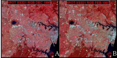
SPOT Multi_Spectral:
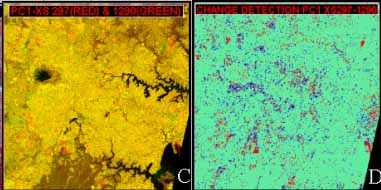
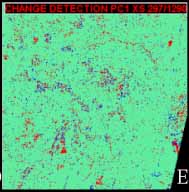
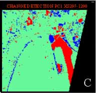
The same process was carried out on the SPOT Multi-Spectral images of the Feb97 and Dec90 Sydney Metropolitan area (Figure 4). However, instead of comparing one band at a time, between XS1 or XS2 or XS3 of Feb97 and Dec90, PC1 of the XS123 of the Feb97 and Dec90 are used. Since Principle Component Analysis maps co-variances of the three input bands, XS1,2,3 into a new axis PC1 (Richards, 1995), it represents the common information of the three input bands. If the user wants to analyze changes in particular Visible Green, Red and Infrared, he/she can do so very easily using the LCAW.
 | |
 | |
 |
Sydney
metropolitan area covering ~38*38 kms A=SPOT XS321 RGB Dec 1990 B=SPOT XS321 RGB Feb 1997 C=PCI XS Feb97(Red) & Dec90(Green) D=Change Detection Sub traction method (PCI XS297-XS1290) E=Change Detection Divsion method (PC1XS297/Xs1290) |
Figure 4. SPOT Multi-Spectral (Dec 90 & Feb 97) of Sydney Metropolitan area and change detections
Discussion
All the simple Red, Blue color display, Subtraction and Division change detection techniques, using SPOT Panchromatic and Multi-Spectral data of the Feb97 and Dec90 render similar results. However, the Division technique on the SPOT Panchromatic does not show as clear as other techniques for the changes of the 3rd run way of the Sydney International Airport. The Subtraction technique of the Panchromatic and the PC1 of the XS123 of the Feb97 and Dec90 provide the best result. An enlarged area of the 3rd Run Way and an area in the South-West of the study are shown in Figure 5. The calculated changed areas (Red color) in the Sydney Metropolitan study area is given as 564.591 sq kilometers.
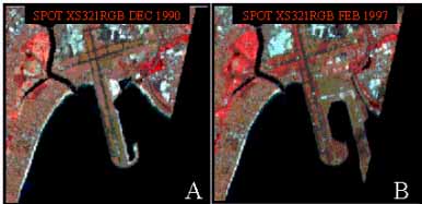 | |
| A=SPOT XS321 RGB Dec 1990 | B=SPOT XS321 RGB Feb 1997 |
> C=Change Detection Subtraction method(PC1XS297-XS1290 | |
Figure 5. SPOT Multi-Spectral (Dec 90 & Feb 97) of Sydney Airport area with 3rd Run Way clearly mapped as changed area.
Conclusion
Multi-date temporal SPOT Panchromatic and Multi-Spectral data can be used and easily map changes that took place over the years. The multi-date datasets are required to be rectified and co-registered and is necessary to standardize the atmospheric conditions between the imagery prior to carrying out change detection. Subtraction and division change detection techniques can be applied to detect changes using either single bands or PC1 of the XS1,2 and 3. Subtraction change detection technique of the Panchromatic and the PC1 of the Feb97 and Dec90 provide the best result. Verification of the changes in the field is necessary for accuracy assessment.
References
- Richards, J. A. (1995) Remote Sensing Image Analysis (An Introduction), (2nd Edition), Springer-Verlag Publications, 340 p