| GISdevelopment.net ---> AARS ---> ACRS 2000 ---> Landuse |
Identification of Landslides
Induced by Chi-Chi Earthquake using Spot Multispectral Images
Yu-Chuan Kuo, Hui-Chung Yeh,
Research Assistant and Post-Doctoral Research Associate
Ke-Sheng Cheng, Chia-Ming Liou, and Ming-Tung Wu,
Associate Professor and Professors
Agricultural Engineering Department/Hydrotech Research Institute,
National Taiwan University, Taipei, Taiwan
Tel: +886-2-2366-1568, Fax: +886-2-2363-5854
E-MAIL : rslab@ccms.ntu.edu.tw
Keywords: change detection, image rectification,
kriging, remote sensing
Abstract:
Landuse change detection using remotely sensed images has been widely investigated. Most applications of this type involve either image differencing or image classification using multitemporal images. If multitemporal images are to be used for quantitative analysis based on their radiometric information, as in the case of change detection or landuse classification, geometric rectification and radiometric correction must be performed priori to subsequent image analyses. In particular, geometric rectification has significant effect on the accuracy of landuse change detection in areas of rugged terrain. Remote sensing image rectification is commonly done by applying a polynomial trend-mapping (PTM) model to image coordinates and map coordinates of ground control points. A major drawback of the PTM model is that it does not capture the random characteristics of terrain elevation. In this study a new anisotropic spatial modeling approach of image-to-image registration is applied to identify landslides induced by the ferocious Chi-Chi earthquake. The approach considers residuals of the PTM model as anisotropic random fields, and employs the ordinary kriging method for spatial interpolation of the residual random fields. By means of a cross validation procedure and visual check, we found that high accuracy of image-to-image registration was achieved. Band-ratioing technique was also employed for relative radiometric normalization. From the gray-level histograms of pre- and post-earthquake band-ration images, we determined the areal percentage of landuse changes in the study area. Image differencing was then performed using the pre- and post-earthquake band-ratio image pair. Finally, a gray-level threshold of the band-ratio-difference image is assigned as the value its exceeding probability equals the areal percentage of landuse change. DTM data of the study area was also used to further restrict landslide areas to steep slope areas.
1. Introduction
Change detection has been one of the major applications of remote sensing since 1960s. There are many approaches to change detection including post-classification comparison, temporal image differencing, temporal image ratioing, multifractal analysis, Bayesian probabilistic method, etc. Despite of their differences in change identification algorithms, accurate spatial registration of the various dates of imagery is a requirement for all these methods. There are essentially two different categories of image rectification approaches, the deterministic and the statistical approaches. The deterministic approach relies on data of the flight parameters and the terrain information, and is effective when types of distortion are well characterized (Richards, 1995). The statistical approach, by means of a ground-control-points (GCP) data set, establishes mathematical relationship between image coordinates and their corresponding map coordinates using standard statistical procedures. The most widely used method in this category is the polynomial trend mapping (PTM) technique that employs polynomial regression equations to relate image coordinates and their corresponding map coordinates. Although commonly applied, the PTM technique often yields significant registration errors in mountainous or rugged terrain areas. Cheng et al. (2000) proposed an anisotropic spatial modeling (ASM) approach using ordinary kriging estimation for image rectification. The approach takes into account the spatial variation structure of terrain elevation, and yields zero registration error at GCPs. For the purpose of identifying terrain changes such as landslides induced by the ferocious Chi-Chi earthquake, the ASM approach is adopted in this study.
2. Study Area and Data
The Experimental Forest of National Taiwan University (EF-NTU) locates in central Taiwan and covers a total area of 32,781 hectares. The area is very close to the center of the Chi-Chi earthquake, occurred in September 21, 1999, and suffered severe damages. Two SPOT multispectral images, acquired on 01/04/1999 and 01/10/1999, are used in this study.
3. Image Registration
In contrast to the commonly applied image-to-map registration, we perform the image-to-image registration to identify changes between two images. The reason of image-to-image registration is that the major earthquake significantly changes terrain features in many mountain areas, and selecting GCPs using maps becomes very difficult. The ordinary kriging approach of image-to-image registration is as follows.
An example of image-to-image registration by the ASM approach is shown in Figures 1 and 2.
4. Change Detection
Change detection in this study involves three steps: spectral (or band) ratioing, temporal image differencing, and determination of change-no change threshold. Since images acquired before and after the earthquake have different atmospheric conditions, band ratioing analysis is performed to effectively compensate for brightness variation caused by different atmospheric conditions. Figures 3 shows that brightness of the IR image before the earthquake is lower that that of the postearthquake image. After the IR/R band-ratioing, brightness values of the two images are very close. The second step of change detection is to determine the absolute difference between the two pre- and post-earthquake (IR/R) images. Figure 5 illustrates the difference image. By comparing histograms of the two (IR/R) band-ratio images, we determine the areal percentage of changes. Finally, the change-no change threshold is determined by locating the grey level, at which exceeding probability equals the areal percentage of landuse changes, from the histogram of the difference image. Figure 6 shows an example of detected changes in the study area. DTM data are used to generates a slope image of the study area, and landslide identification is restricted only in the area with slope steeper than 18o. Up to the present, many of the identified landslide areas have been verified to by field investigations.
5. Conclusions
In this study we demonstrate that the anisotropic spatial modeling approach of image-to-image registration yields high registration accuracy in mountainous and rugged terrain areas. The band-ratioing technique yields close brightness values for two SPOT images acquired prior to and after the Chi-Chi earthquake. The multi-temporal differencing technique yields a difference image using two (IR/R) images, and a threshold grey-level is determined for successful change detection.
References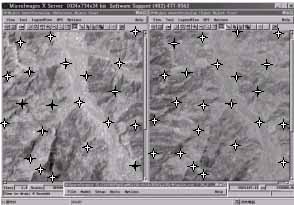
Figure 1. Image-to-image GCPs selection. (Left:pre-earthquake, Right:post-earthquake)
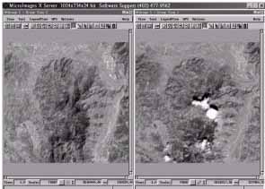
Figure 2. Result of image-to-image registration by the ASM approach.
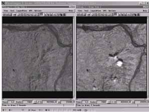
Figure 3. Pre- (left) and post-earthquake (right) IR images.
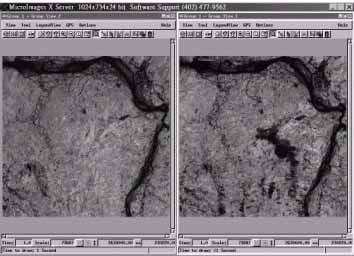
Figure 4. Pre- (left) and post-earthquake (right) band-ratioed (IR/R) images.
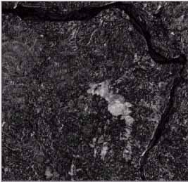
Figure 5. (IR/R) difference image
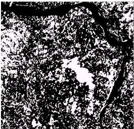
Figure 6. Image of detected changes (white areas).
Abstract:
Landuse change detection using remotely sensed images has been widely investigated. Most applications of this type involve either image differencing or image classification using multitemporal images. If multitemporal images are to be used for quantitative analysis based on their radiometric information, as in the case of change detection or landuse classification, geometric rectification and radiometric correction must be performed priori to subsequent image analyses. In particular, geometric rectification has significant effect on the accuracy of landuse change detection in areas of rugged terrain. Remote sensing image rectification is commonly done by applying a polynomial trend-mapping (PTM) model to image coordinates and map coordinates of ground control points. A major drawback of the PTM model is that it does not capture the random characteristics of terrain elevation. In this study a new anisotropic spatial modeling approach of image-to-image registration is applied to identify landslides induced by the ferocious Chi-Chi earthquake. The approach considers residuals of the PTM model as anisotropic random fields, and employs the ordinary kriging method for spatial interpolation of the residual random fields. By means of a cross validation procedure and visual check, we found that high accuracy of image-to-image registration was achieved. Band-ratioing technique was also employed for relative radiometric normalization. From the gray-level histograms of pre- and post-earthquake band-ration images, we determined the areal percentage of landuse changes in the study area. Image differencing was then performed using the pre- and post-earthquake band-ratio image pair. Finally, a gray-level threshold of the band-ratio-difference image is assigned as the value its exceeding probability equals the areal percentage of landuse change. DTM data of the study area was also used to further restrict landslide areas to steep slope areas.
1. Introduction
Change detection has been one of the major applications of remote sensing since 1960s. There are many approaches to change detection including post-classification comparison, temporal image differencing, temporal image ratioing, multifractal analysis, Bayesian probabilistic method, etc. Despite of their differences in change identification algorithms, accurate spatial registration of the various dates of imagery is a requirement for all these methods. There are essentially two different categories of image rectification approaches, the deterministic and the statistical approaches. The deterministic approach relies on data of the flight parameters and the terrain information, and is effective when types of distortion are well characterized (Richards, 1995). The statistical approach, by means of a ground-control-points (GCP) data set, establishes mathematical relationship between image coordinates and their corresponding map coordinates using standard statistical procedures. The most widely used method in this category is the polynomial trend mapping (PTM) technique that employs polynomial regression equations to relate image coordinates and their corresponding map coordinates. Although commonly applied, the PTM technique often yields significant registration errors in mountainous or rugged terrain areas. Cheng et al. (2000) proposed an anisotropic spatial modeling (ASM) approach using ordinary kriging estimation for image rectification. The approach takes into account the spatial variation structure of terrain elevation, and yields zero registration error at GCPs. For the purpose of identifying terrain changes such as landslides induced by the ferocious Chi-Chi earthquake, the ASM approach is adopted in this study.
2. Study Area and Data
The Experimental Forest of National Taiwan University (EF-NTU) locates in central Taiwan and covers a total area of 32,781 hectares. The area is very close to the center of the Chi-Chi earthquake, occurred in September 21, 1999, and suffered severe damages. Two SPOT multispectral images, acquired on 01/04/1999 and 01/10/1999, are used in this study.
3. Image Registration
In contrast to the commonly applied image-to-map registration, we perform the image-to-image registration to identify changes between two images. The reason of image-to-image registration is that the major earthquake significantly changes terrain features in many mountain areas, and selecting GCPs using maps becomes very difficult. The ordinary kriging approach of image-to-image registration is as follows.
- Select a set of GCPs using images acquired before and after the earthquake.
- Perform the first order polynomial trend mapping to map the two images.
- Consider the registration errors in E-W and N-S directions as two residual random fields and separately perform the anisotropic variogram modeling for each random field.
- Apply the ordinary kriging estimation to the residual random fields using anisotropic variograms established in step (3).
- Final result of the image-to-image registration is obtained by adding ordinary kriging estimates of the residual fields to the trend field estimated by PTM.
An example of image-to-image registration by the ASM approach is shown in Figures 1 and 2.
4. Change Detection
Change detection in this study involves three steps: spectral (or band) ratioing, temporal image differencing, and determination of change-no change threshold. Since images acquired before and after the earthquake have different atmospheric conditions, band ratioing analysis is performed to effectively compensate for brightness variation caused by different atmospheric conditions. Figures 3 shows that brightness of the IR image before the earthquake is lower that that of the postearthquake image. After the IR/R band-ratioing, brightness values of the two images are very close. The second step of change detection is to determine the absolute difference between the two pre- and post-earthquake (IR/R) images. Figure 5 illustrates the difference image. By comparing histograms of the two (IR/R) band-ratio images, we determine the areal percentage of changes. Finally, the change-no change threshold is determined by locating the grey level, at which exceeding probability equals the areal percentage of landuse changes, from the histogram of the difference image. Figure 6 shows an example of detected changes in the study area. DTM data are used to generates a slope image of the study area, and landslide identification is restricted only in the area with slope steeper than 18o. Up to the present, many of the identified landslide areas have been verified to by field investigations.
5. Conclusions
In this study we demonstrate that the anisotropic spatial modeling approach of image-to-image registration yields high registration accuracy in mountainous and rugged terrain areas. The band-ratioing technique yields close brightness values for two SPOT images acquired prior to and after the Chi-Chi earthquake. The multi-temporal differencing technique yields a difference image using two (IR/R) images, and a threshold grey-level is determined for successful change detection.
References
- Cheng, K.S., Yeh, H.C., and Tsai, C.H., 2000. An anisotropic spatial modeling approach for remote sensing image rectification. Remote Sensing of Environment, Vol. 73, N0. 1, pp. 46-54.
- Richards, J.A., 1995. Remote Sensing Digital Image Analyis, Springer-Verlag, Berlin, pp. 54-57.
Figure 1. Image-to-image GCPs selection. (Left:pre-earthquake, Right:post-earthquake)
Figure 2. Result of image-to-image registration by the ASM approach.
Figure 3. Pre- (left) and post-earthquake (right) IR images.
Figure 4. Pre- (left) and post-earthquake (right) band-ratioed (IR/R) images.
Figure 5. (IR/R) difference image
Figure 6. Image of detected changes (white areas).