| GISdevelopment.net ---> AARS ---> ACRS 2000 ---> Poster Session 3 |
Application of Remote Sensing
Image Data in the Analysis of Land Use Management for Agriculture in
Chianan Irrigation Project in Taiwan
You Jenn Ming, Kiyoshi
Torii, Yoshiaki Mori, Ryohei Kada
Graduate School of Agriculture, Kyoto University
Oiwkecho, Kitashirakawa, Sakyoku, Kyoto, Japan Te. & Fax.: (81)-75-753-6459
E-mai:l Torii@kais.kyoto-u.ac.jp
Key
WordsGraduate School of Agriculture, Kyoto University
Oiwkecho, Kitashirakawa, Sakyoku, Kyoto, Japan Te. & Fax.: (81)-75-753-6459
E-mai:l Torii@kais.kyoto-u.ac.jp
land use , Chianan Irrigation Project , system dynamics
Abstract
Wuzanto dam completed in 1930 is acting as a water source for irrigation of the area of about 150,000 ha covering T'ai-nan, and Chia-i in South Taiwan and playing a role of food supply base in Taiwan for 70 years.
We attempted an analysis of agricultural economic evaluations of land-use changes in the recent 20 years using satellite image data as well as field survey. Based on this analysis, we performed statistical analysis of agricultural production aiming at finding more effective use of this irrigation project.
Introduction
Farmland use has a close relationship to food production and appears to have a profound effect on the agricultural development. Therefore, understanding the change in farmland use has long been a major focus of research in Agronomy.

Figure 1: Chainan Irrigation Project |
In this paper we first investigate a change in cultivated land use by using remote sensing image data, and secondly, attempt to establish a model that indicates the possible change of farmland using system dynamics. The model in this study is expected to produce a result close to the reality, thus would be able to provide future reference for land management for the agricultural authority.
The paper is organized as follows: the first part is a brief description of the Chianan irrigation project and discussion of its effect on agricultural production around that area. Secondly, we analyze the change of farmland use in Chianan irrigated zone using remote sensing image data. Then we use a system dynamic model to discuss the possible changes of farmland use in Chianan zone. The last part summarizes the analysis and point out its policy implications.
The Chianan Irritagion Project and Its Effect on Agliculture
The Chianan irrigation project is located in the south-western part of Taiwan and was built in 1930. Its irrigated area included 50000 ha of cultivated land north of Pei-Kang river and 100000 ha of cultivated land south of Pei-Kang river (See figure1).
The Chianan irrigation project consists of 2 smaller irrigation systems: Wushanto reservoir irrigation system and Cho main canal irrigation system. The former set up a pumping station in Linnai to get water from Zhoushui river. The latter set up a dam and a tunnel in Nansei to get water from Tsengwen river. In addition, there are 100km of main line, 1200km of branch line, 7400km of little line, 960km of escape canal and 6000km of little escape canal built in the Chianan irrigation project. It was the biggest irrigation project in Taiwan during the colonial period. Figure 1: Chainan Irrigation Project
After the Chianan irrigation project was accomplished, there are three obvious effects on the agricultural production:
- Larger irrigated area: Before the building of the Chianan irrigation project, there were only 27,821 jia of irrigated area in Tainan. But after the construction, the irrigated area enlarged to 188,867 jia, which was the largest irrigated zone in Taiwan at that time.
- Changed upland fields into paddy fields: According to Taiwan agricultural yearbook, from 1932 to 1937, there was just little change of cultivated land in Tainan zone, but the size of paddy fields area increased twice in the same period. The reason of farmland improvement was establishment of the Chianan irrigation project.
- 3-year-rotation system: Since the irrigated area of Chianan irrigation project was too large to irrigate all the cultivated lands once each year, a 3-years-rotation system was adopted. This system set every 150 ha of cultivated land as one unit, then divided it into three different crop divisions. The three divisions were rice area, sugarcane area and miscellaneous crops area, and farmers took turns planting these crops in their field each year.
By the way, the 3-year-rotation system had been changed from 3-year-once-rice-cultivated to 3-year-twice-rice-cultivated after War II because of agricultural technological progresses such as farmland improvement, seed improvement and the construction of new irrigated facility. Furthermore, on one hand, after the rotation area has decreased and double-cropped field area has increased, the output of rice increased dramatically. On the other hand, as the national income increased, people have reduced the consumption of rice and increased the consumption of meat, vegetables and fruits. This resulted in excessive supply of rice, therefore transformation of rice field to farmland was promoted by Taiwan's government since 1970s. Thereby, paddy field began to decrease and dry farmland increased.
In Tainan prefecture, for instance, paddy field area was 40,133 ha in 1950 and increased to 54,473 ha in 1975, and then decreased to 33257 ha in 1998. In the same time, upland field area was 31,427ha in 1950 and increased to 43,723 in 1998. Figure 2 shows the plant areas of rice, sweet potato and sugarcane were decreasing from the beginning of the 1970s, and plant areas of vegetables, fruits and corn were increasing from the 1960s.
| Item | Production | Yield per ha | |||
| Before | After | Before | After | ||
| Rice | Planted area (jia) | 13,160 | 50,000 | - | - |
| Quantity (dan) | 107,162 | 656,500 | 8.14 | 13.13 | |
| Value (yen) | 1,543,132,800 | 9,453,600,000 | 117,260 | 189,070 | |
| SugarCane | Planted area (jia) | 31,486 | 50,000 | - | - |
| Quantity (jin) | 1,379,898,838 | 3,882,650,000 | 43,826 | 77,653 | |
| Value (yen) | 6,374,534,650 | 17,860,190,000 | 201,600 | 357,200 | |
Source:State government of Tainan, The general outlook of Tainan irrigation works.

Figure2: Changes of plant areas of Tainan prefecture |
Application of Satellite Image Data
As the satellite images of south Taiwan, Landsat TM, SPOT HRV and JERS-1 SAR are applicable at the Japanese receiving station and these were supplied by National Space Development Agency of Japan. The results of analysis will be given at the time of presentation.

Figure 3: Changes in land use of Tainan prefecture |
Land use is in relevant to geographical environment and economic activities, thus different geographical environments and different regional economic activities would yield different kinds of land use.
In previous research of land use in agricultural economics, the analytical approach used most are time series model and regressive model. However, in order to understand the complex problem of land use, system dynamic approach and econometrics have been adopted increasingly. System dynamic approach is especially well disposed in nonlinear relation or while lacking part of the data, it also is suitable for analysis of long-term trend.
| Mission | Sensor | Path-Row | Obs. Date | Mission | Sensor | Path-Row | Obs. Date |
| Landsat | TM | 118-44 | 21 July 90 | JRERS-1 | SAR | 94-261 | 31 May 98 |
| SPOT | HRV | 298-304 | 14 Oct 92 | " | " | 93-262 | " |
| " | " | 298-304 | 3 Mar 93 | " | " | 95-261 | 11 Oct 98 |
| " | " | 298-304 | 8 Mar 93 | " | " | 94-261 | 9 Aug 96 |
| " | " | 298-303 | 19 Jan 99 | " | " | 93-262 | 5 Nov 96 |
| " | " | 298-303 | 22 Nov 99 | " | " | 95-261 | 28 Aug 98 |
| " | PAN | 298-304 | 9 Feb 99 | " | " | 94-261 | 2 Dec 94 |
| " | " | 298-304 | 26 Oct 99 | " | " | 93-262 | 27 Aug.98 |
The system dynamic model developed in this paper is built with the graphical programming language STELLA. In the first step we stipulated the scope of research., then we consider the changes of objects (stock) depend on some factors (flow). Since these factors are influenced by others variables (converters) therefore we connect these stocks, flows and converters with a relation of feedback or infrastructures. Finally, we install coefficient for every variables according to data from the real world and then run the model.
The result from the model is compared to real life data, if they were dissimilar then there were variables that had wrong effects on the model or the coefficients installation was incorrect. Then, we revised the model and ran it again.

Figure 4: change in farmland |
| Year | Forecast values | Year | Forecast Values |
| 1991 | 96,898 | 2001 | 93,397 |
| 1992 | 96,547 | 2002 | 93,043 |
| 1993 | 96,196 | 2003 | 92,691 |
| 1994 | 95,847 | 2004 | 92,339 |
| 1995 | 95,501 | 2005 | 91,987 |
| 1996 | 95,155 | 2006 | 91,634 |
| 1997 | 94,806 | 2007 | 91,280 |
| 1998 | 94,455 | 2008 | 90,926 |
| 1999 | 94,103 | 2009 | 90,573 |
| 2000 | 93,750 | 2010 | 90,220 |
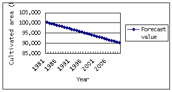
Figure 5: Forecast in farmland
Conclusion
The Chianan irrigation project has played a major role in agricultural development in Chianan zone in the past. Not only did it help raising crops production in the Chianan area but also improved the farmers' economics. However, after the high economic growth, agricultural industry began to go downhill, and the effect of Chianan irrigation project became smaller than before. Recently other than water for agriculture, it has been utilized to provide municipal water and industrial water. The Chianan irrigation project would continues to act as an important role in the economic development in Chianan zone in the future.
Fortunately, Lansat TM image data, SPOT HRV image, JERS-1 SAR image were available. Although it is far from saying that we have analyzed the imagesbfully at the present stage, we could grasp the whole framework of Chianan Irrigation Project area. We are thinking to advance analysis by dividing the area into small blocks, taking time-series data based on the images and comparing them with statistical data in future.
In order to understand the complicated relationship of modern society, interdisciplinary academic research has been receiving increased attention. This paper attempts to combine remote sensing image data and system dynamics model to the analysis of farmland use. In the future study we will focus on this approach to difference types of land user.
Acknowledgement
In ending the paper, we would like to express our deep gratitude to NASDA, RESTEC in Japan and EROS Data Center in USA for satellite image data supply. This study was supported by Scientific Research Fund for Basic Researches (A)(1) of Ministry of Education Japan (Project No. 11306015, represented by Kiyoshi Torii).
References
- Bruce, Hannon and Matthias, Ruth. Dynamic modeling. New York: Springer-Verlag, 1994.
- Bruce, Hannon and Matthias, Ruth. Modeling dynamic economic systems. New York: Springer-Verlag, 1997.
- Department of agriculture and forestry Taiwan provincial government, Taiwan agricultural yearbook. 1950-98; State government of Tainan. The general outlook of Tainan irrigation works, 1933.