| GISdevelopment.net ---> AARS ---> ACRS 2000 ---> Landuse |
Investigation of Land use in
Relation to Landslide by using Gis
R.Ajalloeian (B.Sc, M.Sc, Ph.D.)
Department of Geology, Isfahan University, Isfahan-Iran
R. Karami (B.Sc, M.Sc)
Department of Geology, Isfahan University, Isfahan-Iran
M.Nikzad (B.Sc, M.Sc)
Natural Resource Organization, Isfahan-Iran
R.Ajalloeian (B.Sc, M.Sc, Ph.D.)
Department of Geology, Isfahan University, Isfahan-Iran
R. Karami (B.Sc, M.Sc)
Department of Geology, Isfahan University, Isfahan-Iran
M.Nikzad (B.Sc, M.Sc)
Natural Resource Organization, Isfahan-Iran
Keywords: Geographic Information System (GIS),
Landslide, Land use, Zonation
Abstract
Similar to other developing countries, Iran is also suffering from environmental hazards. In Iran, its main reason is population pressure due to higher population growth rate and in-migration. The landslide is one example of such phenomenon that affects the household, road and etc. Under this context, the present study has been carried out to approach for better land use plan. In this regard, the role of land use change and its relation to landslide has been investigated. Study area is Poshtkoh of Freydonshahr, which is located in southwest of Isfahan in central of Iran. From the point of view of landslide potential, this area has been detected by using geographic information system (GIS). Using the Arc Inf. Software has done this zonation. It is concluded that the most important landslide points has been occurred in the areas which was changed the land use. These changes are mainly in relation to replacement of forest to grassland and also civil activities. There are different agents that cause the landslide. For this reason, different theme maps such as raining rate map, slope map, hypsometry map and aspect map has been prepared. The final map is achieved by composing different theme maps. By using this map, it is possible to classify the area regarding to hazard rate for land use.
1. Introduction
Landslide is a world wide disaster that has murdered thousands of people and damages million dollar every year. In spite of the fact that the landslide is more manageable and more forecastable as compared with other natural calamities like earthquake and flood, there are less than one percent of the countries that have the landslide maps and few landslide stability potential maps have been prepared. In this paper authors have attempted to prepare the zonation map of the Poshtkoh area of Freydonshahr section, which located in southwest of Isfahan in relation to landslide potential by using GIS in order to land-use.
2. General
The studied region is about two hundreds kilometers far from center of Isfahan. This area is equal to 81819.8 hectares between (49 48 45 - 50 19 2) longitude and (32 37 2 - 32 53 48) latitude (figure 1). Regarding to geomorphology of area, mountains cover more of lands about 68.04% equal to 55970.5 hectares. Also hills have 11.42% equal to 9391.86 hectares and traces have 6.83% equal to 5468.6 hectares and cliffs have 13.71% equal to 11361.8 hectares of the total area.
Water-drainage of the studied project are divided in to four basins and some sub basins as follow:
Hydrogeology factors like drainage density, waterflow regimes and etc. cause to mass movement by surface and subsurface erosions. The main rivers, because of more extensive flows, have more potential to washout the deposits and trigger the landslides. For this reasons the landslides which located in the studied area, mostly are around the rivers. Slope morphology is another factor that influences the landslide. Generally the slope alterations are divided in two categories as natural and artificial. Sometimes the rivers washout the slope-toe and unstable it. In other hand, excavations and trenches also could activate the landslides and cause to create a disaster.
One of the important factors that directly increase the landslide potential is precipitation. This phenomenon is in form of snow that is over 50% of precipitation of the area and always occurs at the winter. Eleven classes are considered for the precipitation of this area, which are between 450 to 1400 millimeters.
Destruction of grasslands in addition to land-use changes like replacement of forest and agricultural ground to building, road and other civil structure, is important factor that will cause starting the landslides. The information was collected only around the road because of difficulties to cross the mountains. Twelve important landslides were defined that we pointed them on the map with scale 1:250000.
Since preparing the zonation map of landslide and defining the critical point is via to civil planning, recognition of Poshtkoh landslides was performed by using the geographical information system (GIS) and ARCINFO software. The preparation steps of landslide zonation map are followed.
3. Modelling of the Maps of the Area
After determining the landslides on the 1:250000 maps and digitizing and adding the overall description information of each one, the composition map has been prepared (figure 2). This map can be used for evaluation of various lands in studied area in relation to landslide hazard. It is necessary to mention that all of the maps must be similar in size, area and scale. The maps that were considered to compose with together are as follows:
3.1 Slope map
The slopes are classified in to seven category consist of (0% -2%), (2% - 5%), (5% - 8%), (8% -12%), (12%- 25%), (25% -40%) and (>40%) that includes 677 polygon. the slope polygon with angle greater than 40% has the most extensive area equal to 43243.8 hectares.
3.2 Hypsometry map
All of the elevation of the studied area, divided in to six classes consists of (1600m- 2000m), (2000m-2400m), (2400m- 2800m), (2800m- 3200m), (3200m -3600m), (3600m- 4000m) that greatest polygon and largest area belongs to (2400m- 2800m) class, which has about 68.26 hectares area.
3.3 Climate map
Based on climatically information, four category considered for studied area consist of very humid climate with very cold winter (I.A.I), moderately humid climate with very cold winter (II.B.1), humid climate with very cold winter (II.B.2) and warm semi-humid climate with semi-cold winter (III, C, 3) .The landslides area generally belongs to (III.C.3) and (II.B.1) climates.
3.4 Geology map
From the view point of erosion, the geological formations of area has to be considered. The studied area for purposes of erosion was divided in to four classes consist of (E1), (E2), (E3) AND (E4), with regarding the strength against erosion. So that the (E2) class, has greatest area about 35500.46 hectares.
3.5 Dip-Direction map
Regarding to civil activities such as road construction, the role of dip and dip direction of geological stratums is important. This issue has to be considered in design planning. There are four main dip-direction in this area that the least area belongs to south and the most area belongs to north.
3.6 Rainfall map
Rainfall map includes seven classes consist of (450), (550), (650), (750), (850), (950) and (1050) millimeters. The least area belongs to first class (450 mm) about 283.47 hectares and the greatest area belongs to seventh class (1050 mm) about 42604.4 hectares.
3.7 Soil map
Fourteen classes have been considered that the least area belongs to seventh class that includes marl-limestone mountains with (15%) slope wash about 605.9 hectares. The largest area includes dolo-limestone and orbitoline limestone mountains with (30%) slope wash about 12266.05 hectare.
3.8 Cover crown
Six classes were considered in this classification that include (<10%), (10% - 20%), (20% - 30%), (30% - 40%), (40% - 50%) and (>50%) that the least area belongs to fifth class (40% - 50%) about 64.6 hectares and the largest area belongs to forth class (30% - 40%) about 33968.92 hectares.
4. Methodology
After plotting the landslides on map, all specifications of each one must be determine from previous maps. Then system defined 19 polygons so that the nine of them are polygons of landslides that had been studied in the field and ten remained polygons are the areas that have more potential to occur future landslide. It is interesting that the most of landslides have been occurred around the roads that points out the effect of civil activities like road, building and etc on this phenomenon.
In this stage, the information of twelve landslides must be described for the whole of area and the system automatically find the polygons that have similar characteristics that disposed them to landslide. The final echological units map is consist of a lot of polygons that each polygon has especial characteristics (figure 2). Using the GIS, this map has potential to show the properties of any land regarding to landslide hazards. Smallest polygon area in this study is 25 hectares.
5. Conclusion
Generally the prepared zonation map, specify the areas that have more potential to landslide, so it classify the area regarding to hazard rate for land-use. Therefore the civil operations must consider these areas and avoided them. Also the improvement activities in this area are undeniable.
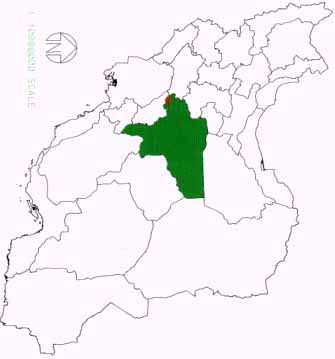
Figure 1: Situation of studied area in Isfahan province and in Iran
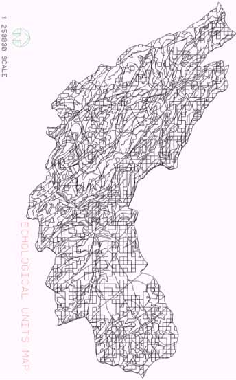
Figure 2: Composition map of Poshtkoh area
Abstract
Similar to other developing countries, Iran is also suffering from environmental hazards. In Iran, its main reason is population pressure due to higher population growth rate and in-migration. The landslide is one example of such phenomenon that affects the household, road and etc. Under this context, the present study has been carried out to approach for better land use plan. In this regard, the role of land use change and its relation to landslide has been investigated. Study area is Poshtkoh of Freydonshahr, which is located in southwest of Isfahan in central of Iran. From the point of view of landslide potential, this area has been detected by using geographic information system (GIS). Using the Arc Inf. Software has done this zonation. It is concluded that the most important landslide points has been occurred in the areas which was changed the land use. These changes are mainly in relation to replacement of forest to grassland and also civil activities. There are different agents that cause the landslide. For this reason, different theme maps such as raining rate map, slope map, hypsometry map and aspect map has been prepared. The final map is achieved by composing different theme maps. By using this map, it is possible to classify the area regarding to hazard rate for land use.
1. Introduction
Landslide is a world wide disaster that has murdered thousands of people and damages million dollar every year. In spite of the fact that the landslide is more manageable and more forecastable as compared with other natural calamities like earthquake and flood, there are less than one percent of the countries that have the landslide maps and few landslide stability potential maps have been prepared. In this paper authors have attempted to prepare the zonation map of the Poshtkoh area of Freydonshahr section, which located in southwest of Isfahan in relation to landslide potential by using GIS in order to land-use.
2. General
The studied region is about two hundreds kilometers far from center of Isfahan. This area is equal to 81819.8 hectares between (49 48 45 - 50 19 2) longitude and (32 37 2 - 32 53 48) latitude (figure 1). Regarding to geomorphology of area, mountains cover more of lands about 68.04% equal to 55970.5 hectares. Also hills have 11.42% equal to 9391.86 hectares and traces have 6.83% equal to 5468.6 hectares and cliffs have 13.71% equal to 11361.8 hectares of the total area.
Water-drainage of the studied project are divided in to four basins and some sub basins as follow:
| Main Basin | A | B | C | D | ||||||||
| Sub Basin | --- |
|
|
DE=DE1'DE2'DE3 DF DH | ||||||||
Hydrogeology factors like drainage density, waterflow regimes and etc. cause to mass movement by surface and subsurface erosions. The main rivers, because of more extensive flows, have more potential to washout the deposits and trigger the landslides. For this reasons the landslides which located in the studied area, mostly are around the rivers. Slope morphology is another factor that influences the landslide. Generally the slope alterations are divided in two categories as natural and artificial. Sometimes the rivers washout the slope-toe and unstable it. In other hand, excavations and trenches also could activate the landslides and cause to create a disaster.
One of the important factors that directly increase the landslide potential is precipitation. This phenomenon is in form of snow that is over 50% of precipitation of the area and always occurs at the winter. Eleven classes are considered for the precipitation of this area, which are between 450 to 1400 millimeters.
Destruction of grasslands in addition to land-use changes like replacement of forest and agricultural ground to building, road and other civil structure, is important factor that will cause starting the landslides. The information was collected only around the road because of difficulties to cross the mountains. Twelve important landslides were defined that we pointed them on the map with scale 1:250000.
Since preparing the zonation map of landslide and defining the critical point is via to civil planning, recognition of Poshtkoh landslides was performed by using the geographical information system (GIS) and ARCINFO software. The preparation steps of landslide zonation map are followed.
3. Modelling of the Maps of the Area
After determining the landslides on the 1:250000 maps and digitizing and adding the overall description information of each one, the composition map has been prepared (figure 2). This map can be used for evaluation of various lands in studied area in relation to landslide hazard. It is necessary to mention that all of the maps must be similar in size, area and scale. The maps that were considered to compose with together are as follows:
3.1 Slope map
The slopes are classified in to seven category consist of (0% -2%), (2% - 5%), (5% - 8%), (8% -12%), (12%- 25%), (25% -40%) and (>40%) that includes 677 polygon. the slope polygon with angle greater than 40% has the most extensive area equal to 43243.8 hectares.
3.2 Hypsometry map
All of the elevation of the studied area, divided in to six classes consists of (1600m- 2000m), (2000m-2400m), (2400m- 2800m), (2800m- 3200m), (3200m -3600m), (3600m- 4000m) that greatest polygon and largest area belongs to (2400m- 2800m) class, which has about 68.26 hectares area.
3.3 Climate map
Based on climatically information, four category considered for studied area consist of very humid climate with very cold winter (I.A.I), moderately humid climate with very cold winter (II.B.1), humid climate with very cold winter (II.B.2) and warm semi-humid climate with semi-cold winter (III, C, 3) .The landslides area generally belongs to (III.C.3) and (II.B.1) climates.
3.4 Geology map
From the view point of erosion, the geological formations of area has to be considered. The studied area for purposes of erosion was divided in to four classes consist of (E1), (E2), (E3) AND (E4), with regarding the strength against erosion. So that the (E2) class, has greatest area about 35500.46 hectares.
3.5 Dip-Direction map
Regarding to civil activities such as road construction, the role of dip and dip direction of geological stratums is important. This issue has to be considered in design planning. There are four main dip-direction in this area that the least area belongs to south and the most area belongs to north.
3.6 Rainfall map
Rainfall map includes seven classes consist of (450), (550), (650), (750), (850), (950) and (1050) millimeters. The least area belongs to first class (450 mm) about 283.47 hectares and the greatest area belongs to seventh class (1050 mm) about 42604.4 hectares.
3.7 Soil map
Fourteen classes have been considered that the least area belongs to seventh class that includes marl-limestone mountains with (15%) slope wash about 605.9 hectares. The largest area includes dolo-limestone and orbitoline limestone mountains with (30%) slope wash about 12266.05 hectare.
3.8 Cover crown
Six classes were considered in this classification that include (<10%), (10% - 20%), (20% - 30%), (30% - 40%), (40% - 50%) and (>50%) that the least area belongs to fifth class (40% - 50%) about 64.6 hectares and the largest area belongs to forth class (30% - 40%) about 33968.92 hectares.
4. Methodology
After plotting the landslides on map, all specifications of each one must be determine from previous maps. Then system defined 19 polygons so that the nine of them are polygons of landslides that had been studied in the field and ten remained polygons are the areas that have more potential to occur future landslide. It is interesting that the most of landslides have been occurred around the roads that points out the effect of civil activities like road, building and etc on this phenomenon.
In this stage, the information of twelve landslides must be described for the whole of area and the system automatically find the polygons that have similar characteristics that disposed them to landslide. The final echological units map is consist of a lot of polygons that each polygon has especial characteristics (figure 2). Using the GIS, this map has potential to show the properties of any land regarding to landslide hazards. Smallest polygon area in this study is 25 hectares.
5. Conclusion
Generally the prepared zonation map, specify the areas that have more potential to landslide, so it classify the area regarding to hazard rate for land-use. Therefore the civil operations must consider these areas and avoided them. Also the improvement activities in this area are undeniable.
Figure 1: Situation of studied area in Isfahan province and in Iran
Figure 2: Composition map of Poshtkoh area