| GISdevelopment.net ---> AARS ---> ACRS 2000 ---> Hazard Mitigation |
Detection of Disaster Damage
Using Changes of City Lights with DMSP/OLS Data in Asia Pacific Region
Izumi NAGATANI*, Genya
SAITO**, Masafumi KODAMA*, Xianfang SONG** and Chris ELVIDGE***
* Computer Center for AFFR, MAFF, Tsukuba, Japan
2-1-2 Kannondai, Tsukuba, Ibaraki, 305-8604, JAPAN
** National Institute of Agro-Environmental Science, MAFF
3-1-1 Kannondai, Tsukuba, Ibaraki, 305-8604, JAPAN
***NOAA National Geophysical Data Center
325 Broadway, Boulder, Colorado 80303 USA
Key
Words* Computer Center for AFFR, MAFF, Tsukuba, Japan
2-1-2 Kannondai, Tsukuba, Ibaraki, 305-8604, JAPAN
** National Institute of Agro-Environmental Science, MAFF
3-1-1 Kannondai, Tsukuba, Ibaraki, 305-8604, JAPAN
***NOAA National Geophysical Data Center
325 Broadway, Boulder, Colorado 80303 USA
Disaster Mitigation, Satellite Image, Network, Database System, DMSP/OLS
Abstract
This research is a part of ANDES (Asia Pacific Network for Disaster Mitigation using Earth Observation Satellite) project. The objective of this project is to detect and inform disasters in Asia-Pacific region as soon as possible by using satellite data and high-capacity network systems. The disaster damage of volcano eruption of Mt Usu, Hokkaido, Japan was detected using the city lights data of DMSP/OLS.
1. Introduction
Now, as global environmental changes such as global warming, anomalous climatic changes, desertification and others are facing urgently to the mankind. They cause serious problems on water, food and energy supporting mankind life. To understand the mechanisms of global environmental change is important and to develop the system of early detecting and warning disasters using satellites is required.
In order to detect and inform disasters in Asia Pacific region as soon as possible, Asia Pacific Network for Disaster Mitigation using Earth Observation Satellite (ANDES) project was started on October 1, 1998 (Kodama,2000, Saito,1999, Song,2000). The ANDES project has executed four study themes, which are Real-time Archiving, Forest Fire, Agriculture Disaster, and Heavy Rain.
It is well known that the meteorological satellite sensors have an ability to detect wildfires (Elvidge,1997). Recently, the meteorological satellite data are tried to use for detection of disaster damage (Takashima,2000). ANDES project are trying to use them for practical utility functions of the detection and early warning system.
The main satellite data used for this project are NOAA/AVHRR, GMS, DMSP/OLS, and TRMM. These data are processed and archived in the Satellite Image Database System for Agriculture, Forestry and Fisheries (SIDaB), which is managed by Computer Center for Agriculture, Forestry and Fisheries Research, the Ministry of Agriculture, Forestry and Fisheries (MAFF), Japan.
DMSP/OLS are suitable for the early identification of earthquake damage area (Hayashi,2000), because that DMSP/OLS possesses a wide swath, high overpass frequency, and high sensitivity for night-time observations in its visible-near infrared waveband (0.47 to 0.95 um).
In March, 2000, The volcanic eruption occurred at Mt.Usu in Hokkaido Japan. There were many influences on human activities. About four thousands people were forced the evacuation for about one month and there were electric power failures in over two thousands houses. The disaster damage will be detected using city lights data by DMSP/OLS.
2. Outline of SIDaB
This research is using SIDaB, therefore the outline of SIDaB will be described at first.
SIDaB is Satellite Image Database System in AFF. Using this system, the user could search and download freely satellite images as he wants through internet. The user could select data easily by menu of times span, area, and also format of data. This system is not only for the researchers in MAFF, Japan, but also for the ordinary person in MAFF and other administrative, environment and disaster prevention agency in Asia and all over world.
SIDaB have collected earth observation and meteorological satellite data and stored from the institutes of MAFF, the relation agencies and institutes of overseas using median of DAT or network. The using network is following.
- Receiving of transmitting of data between the institutes of MAFF using Japan Gigabit Network (JGN)
- Receiving of transmitting of data between overseas using Network of APAN.
- Receiving of transmitting of data between domestic agencies and MAFF using Inter-Ministry Research Information network (IMnet).
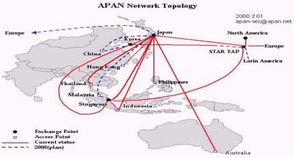
Fig. 1 The Map of APAN Network
The meteorological satellite data, NOAA/AVHRR, GMS, DMSP/OLS, and the tropical rainfall measuring mission TRMM are archived in the SIDaB system. These data has been transferred in real-time or near real-time data from each receiving station or data provider using high performance network to the Computer Center for AFFR, MAFF, Japan.
3. Detection of disaster using DMSP/OLS
3.1 DMSP/OLS data
The U.S. Air Force Defense Meteorological Satellite Program (DMSP) Operational Linescan System (OLS) data are received and used at operational centers on a continual basis in USA. The data are sent daily to the National Geophysical Data Center (NGDC), located in Boulder, Colorado, USA for creation of an archive. From Boulder, Colorado, these data are transferred in semi real time to the Computer Center for Agriculture, Forestry and Fisheries Research (AFFR), MAFF, Japan.
DMSP/OLS is designed for cloud imaging with two spectral bands, visible-near infrared (0.47-0.95 um) and thermal infrared, at 2.7 km resolution and swath of 3000 km. This instrument can also detect faint sources of visible-near infrared emission such as city lights, wildfire, fishing boats and so on.
Four satellites (F12, F13, F14 and F15) data are archived in SIDaB system. Here is a exsample of daily composite image(Fig. 2).
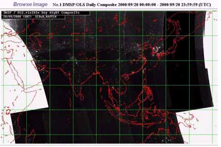
Fig.2 Example of DMSP/OLS Daily Composite image
3.2 Mt. Usu eruption
Mt. Usu volcano, located at Hokkaido, north of Japan, explored on 31 March, 2000. ANDES project tried to detect this eruption's damage area using DMSP/OLS data.
Kohiyama (Hayashi,2000) proposed a method to estimate the impacted area of the earthquake using visible-near infrared imagery. In this method, it is assumed that the brightness of the impacted area would decrease when the buildings collapsed or blackout occurred due to the earthquake. Thus, the impacted areas where brightness decreased significantly after the earthquake compared with before the earthquake were estimated.
Using this method, we studied Usu volcanic disaster and confirmed the ability of DMSP/OLS to detect disaster damage. Two DMSP/OLS data were used, one was acquired on 10 October, 1999, as the pre-event imagery and another was acquired on 4 April, 2000, as the post-event imagery (Fig. 3). These data were acquired with high visible band gain settings under new moon nights. The volcanic eruption influenced areas were estimated according to difference of visible-near infrared emissions between of the pre-event imagery and of the post-event imagery. The estimated image (Fig. 4) shows that there are significant reductions in nighttime lights at Toyako Hot Spring and in Date City. Indeed there are severe ash flows after Usu volcanic eruption around there.
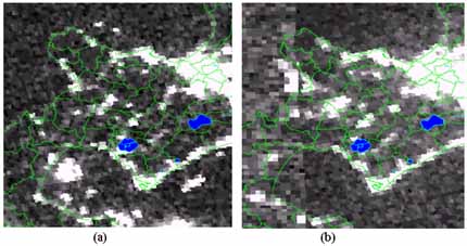
Fig.3 DMSP/OLS visible-near infrared images before(a) and after(b) the volcanic eruption

Fig. 4 The estimated impacted area of eruption of Usu volcano
4. Conclusions
The influenced areas of volcanic eruption were able to estimated, though the resolution of DMSP/OLS is coarse. It means that DMSP/OLS is suitable for detection not only of big earthquake area but also of volcanic eruption, as influencing to human activities.
ANDES project is trying to detect any disaster's damage using SIDaB. DMSP/OLS is useful for early detection of disaster, however digital value of visible-near infrared are saturated in heavy lightning area such as Tokyo or Osaka, even Sapporo city. It is hard to detect disaster damage in such area. Therefore, to detect disaster damage more effectively, we recommend using DMSP/OLS and other satellites.
Acknowledgement
This study is financially supported by Research and Development for Applying Advanced Computational Science and Technology of Japan Science and Technology Corporation.
References
- Elvidge, C.D., K.E.Baugh, E.A.Kihn, H.W.Kroehl, and E.R.Davis, 1997. Mapping City Lights with Nighttime Data from the DMSP Operational Linescan System. Photogrammetric Engineering and Remote Sensing, 63, pp.727-734.
- Hayashi, H., S.Hashitera, M.Kohiyama, M.Matsuoka, N.Maki, H.Fujita, C.D.Elvidge, 2000. International Collaboration for the Early Damaged Area Estimation System Using DMSP/OLS Nighttime Images. Proceedings of IEEE 2000 International Geoscience and Remote Sensing Symposium.(CD-ROM)
- Kodama, M. and X.Song, 2000. Constructing for satellite image database system in AFF. Proceedings of the 28th Conference of the Remote Sensing Society of Japan. pp.259-260. (in Japanese).
- Saito, G., M.dama, and X.Song, 1999. The remote sensing search system, Proceeding of 2nd CEReS Symposium on Environmental Remote Sensing. pp.143-148. (in Japanese)
- Song, X., and M.Kodama, 2000. Application of satellite image database system in AFF. Proceedings of the 28th Conference of the Remote Sensing Society of Japan. pp.257-258. (in Japanese).
- Takashima,M., H.Hayashi, H.Kimura, and M.Kohiyama, 2000. Earthquake Damaged Area Estimation Using DMSP/OLS Night-time Imagery - Application for Hanshin-Awaji Earthquake. Proceedings of IEEE 2000 International Geoscience and Remote Sensing Symposium. (CD-ROM)