| GISdevelopment.net ---> AARS ---> ACRS 2000 ---> Hazard Mitigation |
Asia Pacific Network for
Disaster Mitigation Using Earth Observation Satellite(Andes)(1)- Forest
Fire Detection
Taro SHINMURA (shinmura@cc.affrc.go.jp)*, Haruo
SAWADA**, Izumi NAGATANI*** (Japan)
*, ** World Forest Monitoring Research Team, Forestry and Forest Products Research Institute, Japan (FFPRI), 1 Matsunosato, Kukizaki, Ibaraki, 305-8687 Japan
*, *** Research and Development Applying Advanced Computational Science and Technology, Japan Science and Technology Corporation (JST-ACT)
*** Computer Center of Agriculture, Forestry and Fisheries Research
Keywords*, ** World Forest Monitoring Research Team, Forestry and Forest Products Research Institute, Japan (FFPRI), 1 Matsunosato, Kukizaki, Ibaraki, 305-8687 Japan
*, *** Research and Development Applying Advanced Computational Science and Technology, Japan Science and Technology Corporation (JST-ACT)
*** Computer Center of Agriculture, Forestry and Fisheries Research
disaster mitigation, earth observation satellite, forest fire, real time system, NOAA
Abstract
The High Resolution Picture Transmission (HRPT) data of Advanced Very High Resolution Radiometer (AVHRR) aboard the National Oceanic and Atmospheric Administration (NOAA) Polar Orbiting Environmental Satellites (POES) are received in Japan and Thailand, and these data are transferred in real time to the computer center of Agriculture, Forestry and Fisheries research in Tsukuba. Real time fire detecting system has been processing AVHRR data covering most of East and Southeast Asian countries and detecting thermal spots since May 2000. Products of this system with Defense Meteorological Satellite Program (DMSP) fire products shows the locations of thermal spots and they are put on the web site. In 2000, the number of thermal spot increased explosively in March and July. In Thailand and neighboring countries, and in Indonesia, the number of thermal spots reached maximum in March and July, respectively. It is because March and July is in dry season severally. Time-series analysis shows that almost all thermal spots disappeared within a day in and around Thailand, and each cluster of the spots consisted less than ten. But in Indonesia, thermal spots sometimes appeared several days in same position and clusters of such spots consisted more than ten. The former pattern shows the thermal spots are controlled fire, and the latter one is potentially uncontrollable or wild fire.
1. Introduction
Severe natural disasters are often cause by global climate changes and they are becoming worse, and damage of human activities is increasing. Flooding, drought and big forest fire are the main natural disasters in East and East Asian countries. Therefore, It is strongly required to establish systems for mitigating these natural disasters. ANDES project supported by ACT-JST and started since 1998 aims to develop the operational systems for mitigating the disasters. In this paper, as parts of this project, Tropical Rain Measuring Mission (TRMM) real time system and real time fire detecting system using NOAA/AVHRR data and DMSP/OLS data and its products are introduced, and analysis of fire products are discussed.
2. Andes Project
ANDES project (http://www.affrc.go.jp/ANDES/) is an international project on research and development applying advanced computational science and technology, cooperative project of Forestry and Forest Products Research Institute, National Institute of Agricultural Environment Study, Meteorological Research Institute, Computer Center for Agriculture, Forestry and Fisheries Research, National Space Development Agency and Japan Science and Technology Corporation (JST). The objective of this project is to detect and inform disasters in Asia-Pacific region as soon as possible by using satellite data and high-capacity network systems. The following four study themes are executed.
- to develop a real time archiving and delivering system of satellite data.
- to detect fire and create fire risk map for forest fire mitigation.
- to detect flood and create drought risk map for agricultural disaster mitigation.
- to evaluate the data of TRMM for heavy rain disaster mitigation.
The main satellite data used for this project are NOAA/AVHRR and GMS for forest fire and agricultural disaster, DMSP/OLS for forest fire and TRMM for heavy rain. High-resolution satellite data are also used for observing the situation of the study area according to the necessity. The NOAA/AVHRR data are received in Japan and Thailand and these data are transferred in real time to the computer center of Agriculture, Forestry and Fisheries research in Tsukuba. The DMSP/OLS data and TRMM data are also transferred to the center from USA through the network. These data are processed and archived in the Satellite Image Database (SIDaB) system (http://rms1.agsearch.agropedia.affrc.go.jp/menu_en.html), which is managed by the computer center. As for the NOAA/AVHRR, the nighttime data are used for detecting the hot spot and the daytime data are used for monitoring vegetation condition in global scale. The SIDaB system automatically generates both the weekly composite images and the ten-days' composite image of East Asia region. From the ten-days' composite image, we analyze the vegetation condition and create the terrain images for being used with other disaster products as the base image. The data of global geographic information in Asia Pacific area, such as the Digital Chart of the World (DCW), the global Digital Elevation Model (DEM: 30 arc second), the FAO digital soil maps and meteorological data are also used for producing disaster maps and risk maps. This project aims to develop the operational systems for mitigating the disasters. Therefore, the project has close relations with related institutions in other countries, especially with governmental disaster management units and network specialties.
3. Andes Trmm real Time System
TRMM is a joint mission between NASA and the National Space Development Agency (NASDA) of Japan designed to monitor and study tropical rainfall and the associated release of energy that helps to power the global atmospheric circulation shaping both weather and climate around the globe. Observatory carries five instruments. It includes the first space-borne Precipitation Radar (PR), the TRMM Microwave Imager (TMI), a Visible and Infrared Scanner (VIRS), a Cloud and Earth Radiant Energy System (CERES), and a Lightning Imaging Sensor (LIS).
SIDaB system has been receiving real time PR and TMI data from Goddard Space Flight Center (GSFC)/NASA since Oct 1999 using highly advanced network link. This link mainly consists of Asia-Pacific Advanced Network (APAN) nodes (NASA Integrated Services Network (NISN) => TransPAC => Inter-Ministry Research Information network (IM-net) => Ministry of Agriculture, Forestry and Fisheries Information Network (MAFFIN)).
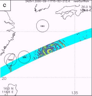
This system processes heavy rain images (using TRMM Science Data and Information System TSDIS Orbit Viewer) and images are renewed in every thirty minutes (http://betleh.cc.affrc.go.jp/~shinmura/trmm/). SIDaB system archives heavy rain images and past images can be easily referred. Figure 1, a) and b) show precipitation images produced by this system. Precipitation on the sea is difficult to be measured by ground radar, but TRMM measures precipitation for both land and sea area in higher resolution (4km) as Figure 1, c). Such information will help weather forecasting and mitigation of torrents on the sea and island, and in the area without highly advanced meteorological equipments
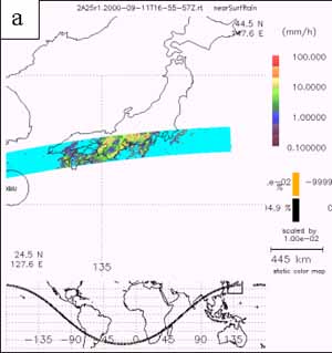
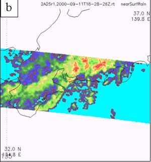
(a) Torrents attached Tokai district, central Japan, 11-12 Sep. 2000. 9 people were killed and 20,000 people were evacuated by flood.
(b) Magnified image.
(c) Typhoon 14th which activated torrents in Tokai district.
4. Forest Fire Detecting in East Asia
In the Southeast Asian region, wild fire and artificially made fire for farming sometimes became large and uncontrollable, and damaged human activities and health. Information for such fire is needed as soon as possible. NOAA/AVHRR data is useful for fire detecting because NOAA POES frequently and widely observe ground. The data is processed and thermal spots which are possible fire are detected in our system.NOAA/AVHRR HRPT data received at Asian Institute of Technology (AIT), Thailand, covering this region is transferred in real time to the computer center of Agriculture,
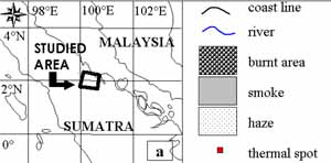
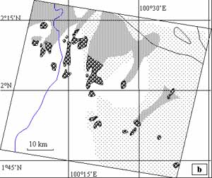
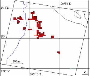
(a) Legends and index map.
(b) Distributions of burnt area, smoke and haze cause by big fire recognized by using SPOT image. Some burnt areas eject smoke and they still burns or smolders. The other areas are already ceased eject smoke and they are hot but does not burn. Smokes spread forward NNE direction and this shows wind direction. Right half are covered with haze which may be produced another areas in Sumatra.
(c) Distributions of thermal spots detected by the ANDES system. Most of all areas which eject smoke (in picture b and meaning "burns") are detected as thermal spots.
Forestry and Fisheries research in Tsukuba through highly advanced network links (Science Information Network (SINET) and IM-net). Shiogama, Yokohama and Ishigaki stations in Japan receive NOAA/AVHRR HRPT data and send through MAFFIN network to the computer center. These data covering most of East and Southeast Asian countries, are processed by the real time fire detecting system. Mainly nighttime data is used for detecting thermal spots, because channel 3 data of AVHRR is not affected by day light, cloud and heated surface by the sun directly. This system uses simple threshold as "T3 > 310K" for detecting thermal spots and this was verified by comparing with high-resolution images of SPOT satellite (Figure 2). AIT data just covers Indonesia, in which haze sometimes caused by big fire and damages closing area. Although this area is often covered with noises which are made at the beginning of receiving and these makes pseudo thermal spots, they are removed by geometrical method in the system.
In the system, both thermal spots of NOAA/AVHRR and fire products of DMSP/OLS data are showed with SPOT/vegetation ten-day's composite using LMF method (Sawada, 1999). Thermal spots sometimes include remanent noises and show heated point which has remanent heat of sun light. DMSP/OLS detects only light and this supports AVHRR thermal spots data for separating these pseudo thermal spots. Real time fire products process three kinds of satellites data and the final images are put on the ANDES web site early next morning. Real time fire detecting system does not only detect thermal spots but also checks time-series of the spots. When a thermal spot is detected on a same place (accuracy is about 1km), the system records and informs by email where and how long the continuous spot exists. Because continuous thermal spots mean big or uncontrolled fire. In fact, in July 2000, in Sumatra , Indonesia, number of detected thermal spots rapidly increased, and many spots continued (5 days in maximum). As shown in figure 2, the area where continuous thermal spots sited, spots distributes as cluster and it consists of more than ten spots, and big fires occurred and they made haze and smokes over several ten kilo meters. On the contrary, in March 2000, in and around Thailand, the number of thermal spots reached maximum. But almost all thermal spots disappeared within a day, and they distributes separately. This means fires in this region were almost controlled and they did not grew dangerous fires.
References
Sawada, Y., Mitsuzuka, N., Sawada, H., 1999. Classification of vegetation types by time series data analysis of vegetation index. Proceedings of the 27th conference of Remote Sensing Society of Japan, pp.73-74.